Hail Map in Burwell, NE on May 14, 2025
The weather event in Burwell, NE on May 14, 2025 includes Hail and Wind maps. 14 states and 452 cities were impacted and suffered possible damage. The total estimated number of properties impacted is 5,370.
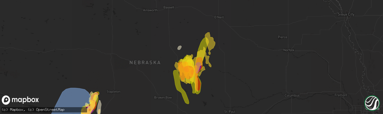
Hail
Wind
5,370
Estimated number of impacted properties by a 1.00" hail or larger2,837
Estimated number of impacted properties by a 1.75" hail or larger180
Estimated number of impacted properties by a 2.50" hail or largerStorm reports in Burwell, NE
Burwell, NE
| Date | Description |
|---|---|
| 05/13/20259:08 PM CDT | Report with photos. Time estimated from radar. |
| 05/13/20258:47 PM CDT | At least the third round of hail in 45 minutes. |
| 05/13/20258:21 PM CDT | Hail up to ping pong ball size...most smaller. |
| 05/13/20258:10 PM CDT | Hail up to half dollar size...most smaller. Report less than a mile south of garfield county line. |
| 05/13/20258:05 PM CDT | A local report indicates 1.00 inch wind near 3 NW Burwell |
| 05/13/20258:04 PM CDT | A local report indicates 1.75 inch wind near Burwell |
| 05/13/20258:03 PM CDT | A local report indicates 1.00 inch wind near 6 NE Taylor |
| 05/13/20257:57 PM CDT | A local report indicates 1.25 inch wind near 2 W Burwell |
| 05/13/20257:27 PM CDT | A local report indicates 1.75 inch wind near 8 W Burwell |
All States Impacted by Hail Map on May 14, 2025
All Cities Impacted by Hail Map on May 14, 2025
- Dunseith, ND
- Muenster, TX
- Saint Jo, TX
- Currie, NC
- Warfield, VA
- McKenney, VA
- Roxboro, NC
- Midland, SD
- Dinwiddie, VA
- Blackstone, VA
- Wilsons, VA
- Dewitt, VA
- Virgilina, VA
- Philip, SD
- Milesville, SD
- Stony Creek, VA
- Kittrell, NC
- Franklinton, NC
- Louisburg, NC
- Newton Grove, NC
- Clinton, NC
- Angier, NC
- Lillington, NC
- Washington, NC
- Florence, SC
- Coats, NC
- Willow Spring, NC
- Morganton, NC
- Valdese, NC
- Nebo, NC
- Union Mills, NC
- Bostic, NC
- Marion, SC
- Linden, NC
- Erwin, NC
- Dunn, NC
- Saint Pauls, NC
- Lumberton, NC
- Mcgregor, MN
- Powhatan, VA
- Benson, NC
- Spring Grove, VA
- Littleton, NC
- Enfield, NC
- Cumberland, VA
- Roseboro, NC
- Disputanta, VA
- Waverly, VA
- Marston, NC
- Wagram, NC
- Kilgore, NE
- Nenzel, NE
- Windsor, NC
- Colerain, NC
- Elizabethtown, NC
- Garland, NC
- Fayetteville, NC
- Loris, SC
- Sims, NC
- Salemburg, NC
- Bailey, NC
- Wilson, NC
- Ahoskie, NC
- Conway, SC
- Garysburg, NC
- Pleasant Hill, NC
- Halifax, NC
- Roanoke Rapids, NC
- Murfreesboro, NC
- Charles City, VA
- Valentine, NE
- Pendleton, NC
- Gaston, NC
- Cody, NE
- Williamsburg, VA
- Sumter, SC
- Mullen, NE
- Clarkton, NC
- Manning, SC
- Tar Heel, NC
- Scotland Neck, NC
- Hope Mills, NC
- White Oak, NC
- Oak City, NC
- Goldsboro, NC
- La Grange, NC
- Harrells, NC
- Zebulon, NC
- Godwin, NC
- Laurinburg, NC
- Oxford, NC
- Wakefield, VA
- Rose Hill, NC
- Wallace, NC
- Trego, WI
- Dendron, VA
- Elberon, VA
- Erie, CO
- Lafayette, CO
- North Platte, NE
- Grantsburg, WI
- Faison, NC
- Hudson, CO
- Magnolia, NC
- Teachey, NC
- Longmont, CO
- Keenesburg, CO
- Bennett, CO
- Alcolu, SC
- Roggen, CO
- Campobello, SC
- Chesnee, SC
- Hobgood, NC
- Willard, NC
- Aberdeen, ID
- Broadway, NC
- Fuquay Varina, NC
- Longs, SC
- Kinston, NC
- Inman, SC
- Comstock, NE
- Arcadia, NE
- Ansley, NE
- Thedford, NE
- Saint Francis, SD
- Crookston, NE
- Belvidere, SD
- Long Valley, SD
- White River, SD
- Tryon, NE
- Broken Bow, NE
- Sargent, NE
- Mission, SD
- Westerville, NE
- Burwell, NE
- Taylor, NE
- Gering, NE
- Scottsbluff, NE
- Wood, SD
- Maywood, NE
- Sterling, CO
- Hershey, NE
- Martin, SD
- Wellfleet, NE
- Otis, CO
- Akron, CO
- Potter, NE
- Yuma, CO
- Stratton, CO
- Seneca, NE
- Brewster, NE
- Wanblee, SD
- Wood Lake, NE
- Eckley, CO
- Kirk, CO
- Allen, SD
- Johnstown, NE
- Dunning, NE
- Purdum, NE
- Wray, CO
- Ainsworth, NE
- Idalia, CO
- Vernon, CO
- Long Pine, NE
- Sutherland, NE
- Hayes, SD
- Anselmo, NE
- Sedgwick, CO
- Stapleton, NE
- Elsmere, NE
- Parkton, NC
- Fort Pierre, SD
- Saint Francis, KS
- Haigler, NE
- Holyoke, CO
- Ord, NE
- Halsey, NE
- Elyria, NE
- Champion, NE
- Bird City, KS
- Whitman, NE
- Springview, NE
- Amherst, CO
- Haxtun, CO
- Paoli, CO
- Madrid, NE
- Julesburg, CO
- Venango, NE
- Imperial, NE
- Grant, NE
- Elsie, NE
- Ogallala, NE
- Merriman, NE
- Paxton, NE
- Arthur, NE
- Keystone, NE
- Bishop, TX
- Roma, TX
- Scotia, NE
- North Loup, NE
- Zapata, TX
- Litchfield, NE
- Hyannis, NE
- Bassett, NE
- Loup City, NE
- Amelia, NE
- Stuart, NE
- Atkinson, NE
- Ericson, NE
- Chambers, NE
- Butte, NE
- Fairfax, SD
- Ewing, NE
- Lake Andes, SD
- Geddes, SD
- Kingsville, TX
- Inman, NE
- Emmet, NE
- Oneill, NE
- Page, NE
- Farwell, NE
- Rio Grande City, TX
- Elba, NE
- Niobrara, NE
- Greeley, NE
- Orchard, NE
- Springfield, SD
- Tabor, SD
- Avon, SD
- Bartlett, NE
- Tyndall, SD
- Lesterville, SD
- Scotland, SD
- Utica, SD
- Royal, NE
- Wolbach, NE
- Spalding, NE
- Winnetoon, NE
- Creighton, NE
- Viborg, SD
- Clearwater, NE
- Primrose, NE
- Elgin, NE
- Bloomfield, NE
- Neligh, NE
- Woodsboro, TX
- Brunswick, NE
- Plainview, NE
- Mathis, TX
- Odem, TX
- Taft, TX
- Tomball, TX
- Hockley, TX
- Cypress, TX
- Dilley, TX
- Burbank, OK
- Four Oaks, NC
- Rutland, SD
- Colman, SD
- Flandreau, SD
- Egan, SD
- Ruthton, MN
- Elkton, SD
- Edgerton, MN
- Trent, SD
- Jasper, MN
- Pipestone, MN
- Garretson, SD
- Holland, MN
- Woodstock, MN
- Lake Benton, MN
- Balaton, MN
- Hendricks, MN
- Ivanhoe, MN
- Tyler, MN
- Arco, MN
- Russell, MN
- Lynd, MN
- Mount Olive, NC
- Tracy, MN
- Garvin, MN
- Gary, SD
- Clear Lake, SD
- Strandburg, SD
- Goodwin, SD
- Watertown, SD
- South Shore, SD
- Twin Brooks, SD
- Marietta, MN
- Odessa, MN
- Revillo, SD
- Labolt, SD
- Stockholm, SD
- Big Stone City, SD
- Bellingham, MN
- Milbank, SD
- Corona, SD
- Marvin, SD
- Ortonville, MN
- Summit, SD
- Wilmot, SD
- Peever, SD
- Graceville, MN
- Dumont, MN
- Beardsley, MN
- Barry, MN
- Clinton, MN
- Correll, MN
- Renville, MN
- Wabasso, MN
- Iron Belt, WI
- Sacred Heart, MN
- Redwood Falls, MN
- Clements, MN
- Morgan, MN
- Morton, MN
- Franklin, MN
- Hugo, OK
- Sawyer, OK
- Gibbon, MN
- Hector, MN
- Fort Towson, OK
- Buffalo Lake, MN
- Valliant, OK
- Rufe, OK
- Wright City, OK
- Broken Bow, OK
- Stewart, MN
- Hutchinson, MN
- Ringold, OK
- Brush, CO
- Wiggins, CO
- Fort Lupton, CO
- Snyder, CO
- Hillrose, CO
- Log Lane Village, CO
- Fort Morgan, CO
- Fleming, CO
- Strasburg, CO
- Commerce City, CO
- Brighton, CO
- Denver, CO
- Woodrow, CO
- Watkins, CO
- Byers, CO
- Lindon, CO
- Orchard, CO
- Weldona, CO
- Merino, CO
- Harrisburg, NE
- Galeton, CO
- Kersey, CO
- New Raymer, CO
- Stoneham, CO
- Lodgepole, NE
- Padroni, CO
- Atwood, CO
- Carpenter, WY
- Bushnell, NE
- Gill, CO
- Ovid, CO
- La Salle, CO
- Dix, NE
- Iliff, CO
- Peetz, CO
- Grover, CO
- Briggsdale, CO
- Pine Bluffs, WY
- Kimball, NE
- Sidney, NE
- Greeley, CO
- Crook, CO
- Burns, WY
- Ault, CO
- Eaton, CO
- Hereford, CO
- Cheyenne, WY
- Nunn, CO
- Lucerne, CO
- Platteville, CO
- Evans, CO
- Pierce, CO
- Windsor, CO
- Milliken, CO
- Henderson, CO
- Thornton, CO
- Louisville, CO
- Boulder, CO
- Broomfield, CO
- Westminster, CO
- Dupont, CO
- Aurora, CO
- Dacono, CO
- Johnstown, CO
- Gilcrest, CO
- Firestone, CO
- Frederick, CO
- Carr, CO
- Anton, CO
- Joes, CO
- Cope, CO
- Vona, CO
- Seibert, CO
- Flagler, CO
- Kanorado, KS
- Burlington, CO
- Bethune, CO
- Benkelman, NE
- Parks, NE
- Dalton, NE
- Bridgeport, NE
- Gurley, NE
- Bayard, NE
- Chappell, NE
- McDonald, KS
- Edson, KS
- Enders, NE
- Max, NE
- Wauneta, NE
- Goodland, KS
- Hayes Center, NE
- Atwood, KS
- Palisade, NE
- Stratton, NE
- Wallace, NE
- Ludell, KS
- Trenton, NE
- Herndon, KS
- Culbertson, NE
- Dickens, NE
- McCook, NE
- Brule, NE
- Lewellen, NE
- Big Springs, NE
- Lemoyne, NE
- Oshkosh, NE
- Broadwater, NE
- Lisco, NE
- Hillsdale, WY
- Arriba, CO
- Kit Carson, CO
- Hugo, CO
- Levant, KS
- Cheyenne Wells, CO
- Wallace, KS
- Sharon Springs, KS
- Winona, KS
- Weskan, KS
- Colby, KS
- Brewster, KS
- Arapahoe, CO
- Monument, KS


