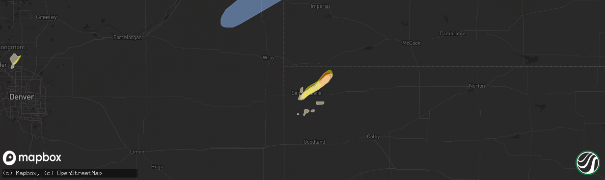
Hail Map in Saint Francis, KS on May 14, 2025
The weather event in Saint Francis, KS on May 14, 2025 includes Hail and Wind maps. 14 states and 452 cities were impacted and suffered possible damage. The total estimated number of properties impacted is 1,298.
Hail
Wind
1,298
Estimated number of impacted properties by a 1.00" hail or larger7
Estimated number of impacted properties by a 1.75" hail or larger0
Estimated number of impacted properties by a 2.50" hail or largerStorm reports in Saint Francis, KS
Saint Francis, KS
| Date | Description |
|---|---|
| 05/13/20258:41 PM CDT | St francis airport kkssaint20. |
| 05/13/20258:12 PM CDT | Reported via social media. Time reported via weather station. |
| 05/13/20258:10 PM CDT | Em relayed report of a tree powerline. Time is estimated. |
| 05/13/20258:00 PM CDT | Report from mping: half dollar |
| 05/13/20257:59 PM CDT | Reported via social media. Quarter to half dollar sized hail measured. |
| 05/13/20257:59 PM CDT | Reported via social media. Quarter to half dollar sized hail measured. |
| 05/13/20257:58 PM CDT | Report from mping: quarter |
| 05/13/20257:58 PM CDT | Delayed report via social media. Photo of accumulating quarter sized hail. Time estimated via other reports and radar. |
| 05/13/20257:05 PM CDT | Ks mesonet cheyenne reported 60 mph gust at 10 meters. |
All States Impacted by Hail Map on May 14, 2025
All Cities Impacted by Hail Map on May 14, 2025
- Dunseith, ND
- Muenster, TX
- Saint Jo, TX
- Currie, NC
- Warfield, VA
- McKenney, VA
- Roxboro, NC
- Midland, SD
- Dinwiddie, VA
- Blackstone, VA
- Wilsons, VA
- Dewitt, VA
- Virgilina, VA
- Philip, SD
- Milesville, SD
- Stony Creek, VA
- Kittrell, NC
- Franklinton, NC
- Louisburg, NC
- Newton Grove, NC
- Clinton, NC
- Angier, NC
- Lillington, NC
- Washington, NC
- Florence, SC
- Coats, NC
- Willow Spring, NC
- Morganton, NC
- Valdese, NC
- Nebo, NC
- Union Mills, NC
- Bostic, NC
- Marion, SC
- Linden, NC
- Erwin, NC
- Dunn, NC
- Saint Pauls, NC
- Lumberton, NC
- Mcgregor, MN
- Powhatan, VA
- Benson, NC
- Spring Grove, VA
- Littleton, NC
- Enfield, NC
- Cumberland, VA
- Roseboro, NC
- Disputanta, VA
- Waverly, VA
- Marston, NC
- Wagram, NC
- Kilgore, NE
- Nenzel, NE
- Windsor, NC
- Colerain, NC
- Elizabethtown, NC
- Garland, NC
- Fayetteville, NC
- Loris, SC
- Sims, NC
- Salemburg, NC
- Bailey, NC
- Wilson, NC
- Ahoskie, NC
- Conway, SC
- Garysburg, NC
- Pleasant Hill, NC
- Halifax, NC
- Roanoke Rapids, NC
- Murfreesboro, NC
- Charles City, VA
- Valentine, NE
- Pendleton, NC
- Gaston, NC
- Cody, NE
- Williamsburg, VA
- Sumter, SC
- Mullen, NE
- Clarkton, NC
- Manning, SC
- Tar Heel, NC
- Scotland Neck, NC
- Hope Mills, NC
- White Oak, NC
- Oak City, NC
- Goldsboro, NC
- La Grange, NC
- Harrells, NC
- Zebulon, NC
- Godwin, NC
- Laurinburg, NC
- Oxford, NC
- Wakefield, VA
- Rose Hill, NC
- Wallace, NC
- Trego, WI
- Dendron, VA
- Elberon, VA
- Erie, CO
- Lafayette, CO
- North Platte, NE
- Grantsburg, WI
- Faison, NC
- Hudson, CO
- Magnolia, NC
- Teachey, NC
- Longmont, CO
- Keenesburg, CO
- Bennett, CO
- Alcolu, SC
- Roggen, CO
- Campobello, SC
- Chesnee, SC
- Hobgood, NC
- Willard, NC
- Aberdeen, ID
- Broadway, NC
- Fuquay Varina, NC
- Longs, SC
- Kinston, NC
- Inman, SC
- Comstock, NE
- Arcadia, NE
- Ansley, NE
- Thedford, NE
- Saint Francis, SD
- Crookston, NE
- Belvidere, SD
- Long Valley, SD
- White River, SD
- Tryon, NE
- Broken Bow, NE
- Sargent, NE
- Mission, SD
- Westerville, NE
- Burwell, NE
- Taylor, NE
- Gering, NE
- Scottsbluff, NE
- Wood, SD
- Maywood, NE
- Sterling, CO
- Hershey, NE
- Martin, SD
- Wellfleet, NE
- Otis, CO
- Akron, CO
- Potter, NE
- Yuma, CO
- Stratton, CO
- Seneca, NE
- Brewster, NE
- Wanblee, SD
- Wood Lake, NE
- Eckley, CO
- Kirk, CO
- Allen, SD
- Johnstown, NE
- Dunning, NE
- Purdum, NE
- Wray, CO
- Ainsworth, NE
- Idalia, CO
- Vernon, CO
- Long Pine, NE
- Sutherland, NE
- Hayes, SD
- Anselmo, NE
- Sedgwick, CO
- Stapleton, NE
- Elsmere, NE
- Parkton, NC
- Fort Pierre, SD
- Saint Francis, KS
- Haigler, NE
- Holyoke, CO
- Ord, NE
- Halsey, NE
- Elyria, NE
- Champion, NE
- Bird City, KS
- Whitman, NE
- Springview, NE
- Amherst, CO
- Haxtun, CO
- Paoli, CO
- Madrid, NE
- Julesburg, CO
- Venango, NE
- Imperial, NE
- Grant, NE
- Elsie, NE
- Ogallala, NE
- Merriman, NE
- Paxton, NE
- Arthur, NE
- Keystone, NE
- Bishop, TX
- Roma, TX
- Scotia, NE
- North Loup, NE
- Zapata, TX
- Litchfield, NE
- Hyannis, NE
- Bassett, NE
- Loup City, NE
- Amelia, NE
- Stuart, NE
- Atkinson, NE
- Ericson, NE
- Chambers, NE
- Butte, NE
- Fairfax, SD
- Ewing, NE
- Lake Andes, SD
- Geddes, SD
- Kingsville, TX
- Inman, NE
- Emmet, NE
- Oneill, NE
- Page, NE
- Farwell, NE
- Rio Grande City, TX
- Elba, NE
- Niobrara, NE
- Greeley, NE
- Orchard, NE
- Springfield, SD
- Tabor, SD
- Avon, SD
- Bartlett, NE
- Tyndall, SD
- Lesterville, SD
- Scotland, SD
- Utica, SD
- Royal, NE
- Wolbach, NE
- Spalding, NE
- Winnetoon, NE
- Creighton, NE
- Viborg, SD
- Clearwater, NE
- Primrose, NE
- Elgin, NE
- Bloomfield, NE
- Neligh, NE
- Woodsboro, TX
- Brunswick, NE
- Plainview, NE
- Mathis, TX
- Odem, TX
- Taft, TX
- Tomball, TX
- Hockley, TX
- Cypress, TX
- Dilley, TX
- Burbank, OK
- Four Oaks, NC
- Rutland, SD
- Colman, SD
- Flandreau, SD
- Egan, SD
- Ruthton, MN
- Elkton, SD
- Edgerton, MN
- Trent, SD
- Jasper, MN
- Pipestone, MN
- Garretson, SD
- Holland, MN
- Woodstock, MN
- Lake Benton, MN
- Balaton, MN
- Hendricks, MN
- Ivanhoe, MN
- Tyler, MN
- Arco, MN
- Russell, MN
- Lynd, MN
- Mount Olive, NC
- Tracy, MN
- Garvin, MN
- Gary, SD
- Clear Lake, SD
- Strandburg, SD
- Goodwin, SD
- Watertown, SD
- South Shore, SD
- Twin Brooks, SD
- Marietta, MN
- Odessa, MN
- Revillo, SD
- Labolt, SD
- Stockholm, SD
- Big Stone City, SD
- Bellingham, MN
- Milbank, SD
- Corona, SD
- Marvin, SD
- Ortonville, MN
- Summit, SD
- Wilmot, SD
- Peever, SD
- Graceville, MN
- Dumont, MN
- Beardsley, MN
- Barry, MN
- Clinton, MN
- Correll, MN
- Renville, MN
- Wabasso, MN
- Iron Belt, WI
- Sacred Heart, MN
- Redwood Falls, MN
- Clements, MN
- Morgan, MN
- Morton, MN
- Franklin, MN
- Hugo, OK
- Sawyer, OK
- Gibbon, MN
- Hector, MN
- Fort Towson, OK
- Buffalo Lake, MN
- Valliant, OK
- Rufe, OK
- Wright City, OK
- Broken Bow, OK
- Stewart, MN
- Hutchinson, MN
- Ringold, OK
- Brush, CO
- Wiggins, CO
- Fort Lupton, CO
- Snyder, CO
- Hillrose, CO
- Log Lane Village, CO
- Fort Morgan, CO
- Fleming, CO
- Strasburg, CO
- Commerce City, CO
- Brighton, CO
- Denver, CO
- Woodrow, CO
- Watkins, CO
- Byers, CO
- Lindon, CO
- Orchard, CO
- Weldona, CO
- Merino, CO
- Harrisburg, NE
- Galeton, CO
- Kersey, CO
- New Raymer, CO
- Stoneham, CO
- Lodgepole, NE
- Padroni, CO
- Atwood, CO
- Carpenter, WY
- Bushnell, NE
- Gill, CO
- Ovid, CO
- La Salle, CO
- Dix, NE
- Iliff, CO
- Peetz, CO
- Grover, CO
- Briggsdale, CO
- Pine Bluffs, WY
- Kimball, NE
- Sidney, NE
- Greeley, CO
- Crook, CO
- Burns, WY
- Ault, CO
- Eaton, CO
- Hereford, CO
- Cheyenne, WY
- Nunn, CO
- Lucerne, CO
- Platteville, CO
- Evans, CO
- Pierce, CO
- Windsor, CO
- Milliken, CO
- Henderson, CO
- Thornton, CO
- Louisville, CO
- Boulder, CO
- Broomfield, CO
- Westminster, CO
- Dupont, CO
- Aurora, CO
- Dacono, CO
- Johnstown, CO
- Gilcrest, CO
- Firestone, CO
- Frederick, CO
- Carr, CO
- Anton, CO
- Joes, CO
- Cope, CO
- Vona, CO
- Seibert, CO
- Flagler, CO
- Kanorado, KS
- Burlington, CO
- Bethune, CO
- Benkelman, NE
- Parks, NE
- Dalton, NE
- Bridgeport, NE
- Gurley, NE
- Bayard, NE
- Chappell, NE
- McDonald, KS
- Edson, KS
- Enders, NE
- Max, NE
- Wauneta, NE
- Goodland, KS
- Hayes Center, NE
- Atwood, KS
- Palisade, NE
- Stratton, NE
- Wallace, NE
- Ludell, KS
- Trenton, NE
- Herndon, KS
- Culbertson, NE
- Dickens, NE
- McCook, NE
- Brule, NE
- Lewellen, NE
- Big Springs, NE
- Lemoyne, NE
- Oshkosh, NE
- Broadwater, NE
- Lisco, NE
- Hillsdale, WY
- Arriba, CO
- Kit Carson, CO
- Hugo, CO
- Levant, KS
- Cheyenne Wells, CO
- Wallace, KS
- Sharon Springs, KS
- Winona, KS
- Weskan, KS
- Colby, KS
- Brewster, KS
- Arapahoe, CO
- Monument, KS


