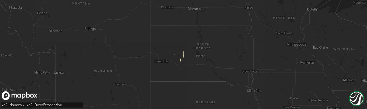
Hail Map on May 14, 2025
The weather event on May 14, 2025 includes Hail and Wind maps. 14 states and 452 cities were impacted and suffered possible damage. The total estimated number of properties impacted is 22,018.
Want more than just the map?
Turn this storm into a full workflow.
- Owner + property data so you know who to knock
- OnDemand branded weather history reports to win the "did we even have hail?" argument
- RoofTrace estimate so reps stop guessing numbers at the door
Bought this map? Upgrade within 7 days and we'll credit the $230. (10-15 min setup call)
Hail
Wind
22,018
Estimated number of impacted properties by a 1.00" hail or larger7,416
Estimated number of impacted properties by a 1.75" hail or larger489
Estimated number of impacted properties by a 2.50" hail or largerStates Impacted by Hail Map on May 14, 2025
Storm reports
Virginia
| Date | Description |
|---|---|
| 05/14/20254:50 PM CDT | Tree down across brownsview lane near beechland rd. Time estimated via radar. |
| 05/14/20251:37 PM CDT | Reports of numerous trees and power lines down in an around clarksville. |
| 05/14/20251:15 PM CDT | Report of a tree down on hwy 49. |
| 05/14/202512:30 PM CDT | Tree down blocking cherrystone lake road... Near its intersection with hodnetts mill road. Time estimated from radar. |
| 05/14/202512:30 PM CDT | Tree downed by thunderstorm winds at the intersection of double bridge road and callands road... Blocking the road. |
| 05/14/202512:10 PM CDT | Tree down blocking graves bridge road. Time estimated from radar. |
| 05/14/202511:20 AM CDT | Tree down along cascade mill road... Near its intersection with loblolly drive. Time estimated from radar. |
North Carolina
| Date | Description |
|---|---|
| 05/14/20255:23 PM CDT | Duplin county 911 reported trees down near the intersection of fussell rd and corinth church rd. Time based on radar. |
| 05/14/20253:38 PM CDT | Tree down across ward rd near us 13. |
| 05/14/20253:00 PM CDT | Picture of quarter sized hail received. Time estimated based on radar. |
| 05/14/20252:20 PM CDT | Trees and power lines down. |
| 05/14/20251:31 PM CDT | Time estimated from radar. |
| 05/14/20251:28 PM CDT | Damage to utility equipment from falling trees. |
| 05/14/202512:05 PM CDT | Tree downed by thunderstorm winds on culver road. |
| 05/14/202511:50 AM CDT | Tree downed by thunderstorm winds on blanch road. |
| 05/14/202511:45 AM CDT | Tree downed by thunderstorm winds on slade road. |
| 05/14/202511:20 AM CDT | Tree downed by thunderstorm winds on quick road. |
Colorado
| Date | Description |
|---|---|
| 05/14/20256:50 PM CDT | Power line down by county road 55 north of iliff. Spotter also reported no power in town. Location and time estimated. |
| 05/14/20256:49 PM CDT | Weatherlink station. |
| 05/14/20256:45 PM CDT | Coagmet station csu67 iliff. |
| 05/14/20256:45 PM CDT | Spotter confident in at least 80 mph wind gusts. Damage to branches 7 to 8 inches in diameter reported... As well as an overturned pivot sprinkler. |
| 05/14/20256:41 PM CDT | Awos station k1jw peetz. |
| 05/14/20256:33 PM CDT | Awos station kako akron. |
| 05/14/20256:32 PM CDT | Awos station k1mw sterling 15 wnw. |
| 05/14/20256:23 PM CDT | Awos station kako akron. |
| 05/14/20256:17 PM CDT | Weatherlink station. |
| 05/14/20256:15 PM CDT | Mesonet station bru01 brush. |
| 05/14/20256:15 PM CDT | Awos station kstk sterling. |
| 05/14/20256:13 PM CDT | Spotter and social media posts of at least one tree down on a house in brush. Time and location estimated. |
| 05/14/20256:12 PM CDT | Weatherlink station. |
| 05/14/20256:12 PM CDT | Multiple 3-4 inch diameter tree limbs down. Time estimated. |
| 05/14/20256:10 PM CDT | Power poles down near the intersection of county road 25 and county road r. Time estimated. |
| 05/14/20255:55 PM CDT | Awos station kfmm fort morgan. |
| 05/14/20255:51 PM CDT | Wunderground station pws-kcofortm56. |
| 05/14/20255:51 PM CDT | Mesonet station co039 wiggins bijou creek. |
| 05/14/20255:28 PM CDT | Measured with vantagepro weather station. Also reported 3-4 inch diameter tree limbs down and minor roof damage to outbuilding. |
| 05/14/20255:25 PM CDT | Mesonet station co222 dearfield. |
| 05/14/20255:23 PM CDT | Awos station k1ow 2 nw pawnee buttes. |
| 05/14/20255:18 PM CDT | Weatherlink station. |
| 05/14/20255:14 PM CDT | Asos station kden denver intl airport. |
| 05/14/20255:07 PM CDT | Raws station tt567 crow creek. |
| 05/14/20254:29 PM CDT | Report from mping: quarter |
| 05/14/20254:21 PM CDT | Report from mping: half dollar |
| 05/14/20254:20 PM CDT | A local report indicates 1.00 inch wind near 1 NE Erie |
| 05/14/20254:16 PM CDT | Report from mping: quarter |
| 05/13/20258:15 PM CDT | Up694. |
| 05/13/20258:10 PM CDT | A local report indicates 63 MPH wind near 4 S Burlington |
| 05/13/20258:04 PM CDT | Wxunderground kcoarapa3. |
| 05/13/20258:03 PM CDT | Asos station kitr burlington co airport. |
| 05/13/20257:59 PM CDT | Delayed report. |
| 05/13/20257:57 PM CDT | Reported via social media. Estimated 60 mph winds with under half mile visibility due to dust. |
| 05/13/20257:55 PM CDT | Awos station kheq holyoke airport. |
| 05/13/20257:53 PM CDT | Mesonet station co048 us 385 holyoke. |
| 05/13/20257:50 PM CDT | Weatherlink station. |
| 05/13/20257:47 PM CDT | Mesonet station ew7003 17 n flagler. |
| 05/13/20257:47 PM CDT | Weatherlink station. |
| 05/13/20257:47 PM CDT | Weatherlink station. |
| 05/13/20257:46 PM CDT | Weatherlink station. |
| 05/13/20257:45 PM CDT | County dispatch reported two trees down on houses within holyoke... Along with other tree damage and power outages. Time estimated. |
| 05/13/20257:44 PM CDT | Ambient weather station my_weather_station_. |
| 05/13/20257:43 PM CDT | Mesonet station co048 us 385 holyoke. |
| 05/13/20257:43 PM CDT | Kcoflagl13 64 mph gust. |
| 05/13/20257:37 PM CDT | Wunderground station pws-kcohaxtu21. |
| 05/13/20257:30 PM CDT | A local report indicates 63 MPH wind near 7 N Stratton |
| 05/13/20257:30 PM CDT | Picked house roof up on nw corner and dropped it again. Broke 4 roof trusses. Healthy 12 inch diameter honey locust tree x 25 feet tall nearby was uprooted. |
| 05/13/20257:29 PM CDT | Weatherlink station. |
| 05/13/20257:29 PM CDT | Wxunderground kcovona4. |
| 05/13/20257:26 PM CDT | Awn site brophy. |
| 05/13/20257:21 PM CDT | Ambient weather site struckmeyer. |
| 05/13/20257:21 PM CDT | Corrects previous tstm wnd gst report from 10 ene clarkville. Ambient weather site struckmeyer. |
| 05/13/20257:15 PM CDT | Site kcoflagl2 reports 61 mph wind gust with thunderstorms in area. |
| 05/13/20257:10 PM CDT | Site rmr ranch reports wind gust of 58 mph. |
| 05/13/20257:08 PM CDT | Weatherlink station. |
| 05/13/20257:04 PM CDT | Corrects previous tstm wnd gst report from 8 nnw flagler. Wunderground site kcoflagl13. |
Kansas
| Date | Description |
|---|---|
| 05/13/202510:15 PM CDT | 16 inch diameter tree uprooted near middle of town. Another similar size tree was uprooted near the visitor center. |
| 05/13/20259:35 PM CDT | Delayed report via social media. Tree trunk split in half. Time estimated based on oberlin awos |
| 05/13/20259:15 PM CDT | K state mesonet. |
| 05/13/20259:03 PM CDT | Cw6099 aprswxnet/cwop. |
| 05/13/20259:02 PM CDT | Off duty nws employee reports roof damage to building. |
| 05/13/20259:00 PM CDT | Up840. |
| 05/13/20259:00 PM CDT | Trained spotter estimated 60 mph wind gust. |
| 05/13/20258:55 PM CDT | K state mesonet. |
| 05/13/20258:54 PM CDT | Reported via social media. Estimated 50-60 mph winds with wall of dust. |
| 05/13/20258:48 PM CDT | Ambient weather. |
| 05/13/20258:45 PM CDT | Trained spotter reports 70 mph wind gusts. Wind gusts were down to 60 mph as of 8:55pm ct. |
| 05/13/20258:45 PM CDT | Off-duty employee reported. Time via weather station. |
| 05/13/20258:45 PM CDT | Delayed report. Numerous healthy 2.6 inch diameter tree limbs down across the property. Time estimated based on prior reports at the location and surrounding area. |
| 05/13/20258:41 PM CDT | St francis airport kkssaint20. |
| 05/13/20258:37 PM CDT | Reported via social media. Estimated at least 60 mph. |
| 05/13/20258:30 PM CDT | Estimated 60 mph gust with very small tree branches down. A lot of pea sized hail also reported. Time provided by spotter. |
| 05/13/20258:23 PM CDT | Corrects previous non-tstm wnd gst report from 1 nne goodland. Asos station kgld goodland. |
| 05/13/20258:15 PM CDT | Off duty nws employee reports a moderately healthy 8 to 12 inch diameter branch snapped. Estimated time. |
| 05/13/20258:12 PM CDT | Reported via social media. Time reported via weather station. |
| 05/13/20258:10 PM CDT | Em relayed report of a tree powerline. Time is estimated. |
| 05/13/20258:05 PM CDT | Leonard farms - kkskanor6. |
| 05/13/20258:00 PM CDT | Report from mping: half dollar |
| 05/13/20257:59 PM CDT | Reported via social media. Quarter to half dollar sized hail measured. |
| 05/13/20257:59 PM CDT | Reported via social media. Quarter to half dollar sized hail measured. |
| 05/13/20257:58 PM CDT | Delayed report via social media. Photo of accumulating quarter sized hail. Time estimated via other reports and radar. |
| 05/13/20257:58 PM CDT | Report from mping: quarter |
| 05/13/20257:05 PM CDT | Ks mesonet cheyenne reported 60 mph gust at 10 meters. |
South Dakota
| Date | Description |
|---|---|
| 05/14/20254:27 AM CDT | Mesonet station 292 7ne milbank |
| 05/14/20254:27 AM CDT | Mesonet station 292 7ne mil |
| 05/14/20254:17 AM CDT | Mesonet station 55 summit |
| 05/14/20253:50 AM CDT | Mesonet station 291 4n altamont |
| 05/14/20252:46 AM CDT | Awos station k4p3 2 s flandreau. |
| 05/14/20251:51 AM CDT | A local report indicates 60 MPH wind near 1 E Hartford |
| 05/14/20251:23 AM CDT | Mesonet station 310 sd rwis parker. Initial gust to 61 mph... Peak of 65 mph at 125 am. |
| 05/14/20251:02 AM CDT | Mesonet station 163 sd rwis freeman. |
| 05/14/202512:36 AM CDT | Personal weather station. |
| 05/13/202511:52 PM CDT | Personal wether station. |
| 05/13/202510:36 PM CDT | Personal weather station. |
| 05/13/202510:30 PM CDT | Lots of dust blew through his farmstead just north of geddes... And blew the barn door open. |
| 05/13/202510:29 PM CDT | Spotter reported that his son in town saw some trees blow down when the storm came through. |
| 05/13/202510:08 PM CDT | Personal weather station. |
| 05/13/20259:45 PM CDT | Personal weather station. |
Nebraska
| Date | Description |
|---|---|
| 05/14/20256:57 PM CDT | A local report indicates 1.75 inch wind near 2 NW Wellfleet |
| 05/14/20256:53 PM CDT | Upr site. |
| 05/14/20256:51 PM CDT | A local report indicates 62 MPH wind near Sidney |
| 05/14/20256:45 PM CDT | Had 2 rounds of 2 inch hail the first at 4:15 mt and 5:45 mt. |
| 05/14/20256:40 PM CDT | A local report indicates 1.75 inch wind near 7 NW Maywood |
| 05/14/20256:34 PM CDT | Bff raws site. |
| 05/14/20256:11 PM CDT | A local report indicates 1.25 inch wind near 5 N Scottsbluff |
| 05/14/20256:11 PM CDT | A local report indicates 1.75 inch wind near 1 N Scottsbluff |
| 05/14/20255:58 PM CDT | Report of an overturned semi on highway 83 mm 174. |
| 05/14/20255:55 PM CDT | A local report indicates 64 MPH wind near Kimball |
| 05/14/20255:33 PM CDT | A local report indicates 1.00 inch wind near 8 ENE Ansley |
| 05/14/20255:30 PM CDT | A local report indicates 1.00 inch wind near Mullen |
| 05/14/20255:06 PM CDT | A local report indicates 1.75 inch wind near 11 WSW Brownlee |
| 05/14/20253:32 PM CDT | A local report indicates 1.75 inch wind near Nenzel |
| 05/13/20259:55 PM CDT | At cambridge airport. Intense outflow from combo of synoptic front and convective outflow. |
| 05/13/20259:45 PM CDT | Intense outflow from combo of synoptic front and convective outflow. |
| 05/13/20259:31 PM CDT | Report of 68 mph gust from pws. |
| 05/13/20259:27 PM CDT | Asos station kmck mccook airport. Visibility down to 1/2 mile due to dust. |
| 05/13/20259:19 PM CDT | 3w 1n trenton... Ne - knetrent7. |
| 05/13/20259:12 PM CDT | Visibility reported of 100 yards with estimated wind gusts of 60 mph as wall of dust moves through. Time provided by spotter. |
| 05/13/20259:08 PM CDT | Report with photos. Time estimated from radar. |
| 05/13/20259:08 PM CDT | A local report indicates 71 MPH wind near 11 NE Dickens |
| 05/13/20259:05 PM CDT | 5 to 10 inch diameter tree branches down across town. |
| 05/13/20259:04 PM CDT | Wnw trenton. 3w 1n trenton... Ne - knetrent7 |
| 05/13/20259:01 PM CDT | A local report indicates 67 MPH wind near 1 NW Sutherland |
| 05/13/20259:00 PM CDT | Public report from a pws 3w 1 n of trenton. |
| 05/13/20258:50 PM CDT | Lorens farms... Ambient weather. |
| 05/13/20258:47 PM CDT | At least the third round of hail in 45 minutes. |
| 05/13/20258:39 PM CDT | Hail to around quarter size...second round of hail in last 11 minutes from a new core. |
| 05/13/20258:33 PM CDT | A local report indicates 73 MPH wind near 10 S Wallace |
| 05/13/20258:31 PM CDT | A local report indicates 71 MPH wind near 4 SE Ogallala |
| 05/13/20258:30 PM CDT | Multiple 4 inch limbs down from trees during thunderstorm. |
| 05/13/20258:28 PM CDT | Hail up to half dollar size...more flat than round. |
| 05/13/20258:23 PM CDT | A local report indicates 76 MPH wind near 4 N Wauneta |
| 05/13/20258:21 PM CDT | Hail up to ping pong ball size...most smaller. |
| 05/13/20258:18 PM CDT | A local report indicates 79 MPH wind near 1 NW Imperial |
| 05/13/20258:15 PM CDT | A local report indicates 82 MPH wind near 2 NNW Grant |
| 05/13/20258:15 PM CDT | Building damage and power poles snapped in imperial. |
| 05/13/20258:12 PM CDT | A local report indicates 59 MPH wind near 1 NNW Imperial |
| 05/13/20258:12 PM CDT | A local report indicates 1.75 inch wind near 4 NW North Platte |
| 05/13/20258:10 PM CDT | Hail up to half dollar size...most smaller. Report less than a mile south of garfield county line. |
| 05/13/20258:08 PM CDT | A local report indicates 72 MPH wind near 11 N Imperial |
| 05/13/20258:05 PM CDT | A local report indicates 1.00 inch wind near 3 NW Burwell |
| 05/13/20258:04 PM CDT | A local report indicates 1.75 inch wind near Burwell |
| 05/13/20258:03 PM CDT | A local report indicates 1.00 inch wind near 6 NE Taylor |
| 05/13/20258:01 PM CDT | A local report indicates 1.75 inch wind near 10 W North Platte |
| 05/13/20258:00 PM CDT | Hail up to quarter size...most smaller. |
| 05/13/20257:57 PM CDT | A local report indicates 1.25 inch wind near 2 W Burwell |
| 05/13/20257:52 PM CDT | A local report indicates 60 MPH wind near 3 SSW Big Springs |
| 05/13/20257:50 PM CDT | A local report indicates 2.50 inch wind near 13 NW North Platte |
| 05/13/20257:49 PM CDT | A local report indicates 65 MPH wind near 6 SSE Chappell |
| 05/13/20257:48 PM CDT | Weatherlink station. |
| 05/13/20257:46 PM CDT | A local report indicates 75 MPH wind near 3 W Lewellen |
| 05/13/20257:39 PM CDT | A local report indicates 58 MPH wind near 3 W Lewellen |
| 05/13/20257:35 PM CDT | A local report indicates 58 MPH wind near 5 WNW Chappell |
| 05/13/20257:35 PM CDT | Relayed report... Time estimated. |
| 05/13/20257:35 PM CDT | A local report indicates 64 MPH wind near Sidney |
| 05/13/20257:35 PM CDT | A local report indicates 1.75 inch wind near 2 S Hershey |
| 05/13/20257:34 PM CDT | A local report indicates 59 MPH wind near 7 SSW Oshkosh |
| 05/13/20257:34 PM CDT | [landspout] estimated location of the landspout. |
| 05/13/20257:33 PM CDT | A local report indicates 63 MPH wind near 10 N Chappell |
| 05/13/20257:30 PM CDT | A local report indicates 59 MPH wind near 1 W Oshkosh |
| 05/13/20257:27 PM CDT | A local report indicates 1.75 inch wind near 8 W Burwell |
| 05/13/20257:23 PM CDT | [landspout] off duty nws employee reported an ongoing landspout 5 miles west of town. |
| 05/13/20257:18 PM CDT | [landspout] estimated location of 1 mile south of sutherland power plant. |
| 05/13/20257:15 PM CDT | Damage to roof on a metal structure - garage like structure... Estimated time. |
| 05/13/20257:11 PM CDT | [landspout] estimated location of 14 miles sw of hershy... Landspout continues on the ground. |
| 05/13/20257:08 PM CDT | [landspout] multiple reports and photos of landspout tornadoes. |
| 05/13/20257:04 PM CDT | Sunol upr site. |
South Carolina
| Date | Description |
|---|---|
| 05/14/20254:25 PM CDT | Spotter report of quarter sized hail in manning. |
Minnesota
| Date | Description |
|---|---|
| 05/14/20254:45 AM CDT | Mesonet station mn036 t.h.28 - graceville - mp 19. |
| 05/14/20254:35 AM CDT | Mesonet station mn137 u.s.75 - ortonville - mp 132.7. |
| 05/14/20253:17 AM CDT | Personal weather station. |
| 05/14/20253:06 AM CDT | Mesonet station mn154 u.s.75 - trosky - mp 30.3. |
| 05/14/20252:52 AM CDT | Video and photos from social media of tree damage and limbs down. |
Cities Impacted by Hail Map on May 14, 2025
- Dunseith, ND
- Muenster, TX
- Saint Jo, TX
- Currie, NC
- Warfield, VA
- McKenney, VA
- Roxboro, NC
- Midland, SD
- Dinwiddie, VA
- Blackstone, VA
- Wilsons, VA
- Dewitt, VA
- Virgilina, VA
- Philip, SD
- Milesville, SD
- Stony Creek, VA
- Kittrell, NC
- Franklinton, NC
- Louisburg, NC
- Newton Grove, NC
- Clinton, NC
- Angier, NC
- Lillington, NC
- Washington, NC
- Florence, SC
- Coats, NC
- Willow Spring, NC
- Morganton, NC
- Valdese, NC
- Nebo, NC
- Union Mills, NC
- Bostic, NC
- Marion, SC
- Linden, NC
- Erwin, NC
- Dunn, NC
- Saint Pauls, NC
- Lumberton, NC
- Mcgregor, MN
- Powhatan, VA
- Benson, NC
- Spring Grove, VA
- Littleton, NC
- Enfield, NC
- Cumberland, VA
- Roseboro, NC
- Disputanta, VA
- Waverly, VA
- Marston, NC
- Wagram, NC
- Kilgore, NE
- Nenzel, NE
- Windsor, NC
- Colerain, NC
- Elizabethtown, NC
- Garland, NC
- Fayetteville, NC
- Loris, SC
- Sims, NC
- Salemburg, NC
- Bailey, NC
- Wilson, NC
- Ahoskie, NC
- Conway, SC
- Garysburg, NC
- Pleasant Hill, NC
- Halifax, NC
- Roanoke Rapids, NC
- Murfreesboro, NC
- Charles City, VA
- Valentine, NE
- Pendleton, NC
- Gaston, NC
- Cody, NE
- Williamsburg, VA
- Sumter, SC
- Mullen, NE
- Clarkton, NC
- Manning, SC
- Tar Heel, NC
- Scotland Neck, NC
- Hope Mills, NC
- White Oak, NC
- Oak City, NC
- Goldsboro, NC
- La Grange, NC
- Harrells, NC
- Zebulon, NC
- Godwin, NC
- Laurinburg, NC
- Oxford, NC
- Wakefield, VA
- Rose Hill, NC
- Wallace, NC
- Trego, WI
- Dendron, VA
- Elberon, VA
- Erie, CO
- Lafayette, CO
- North Platte, NE
- Grantsburg, WI
- Faison, NC
- Hudson, CO
- Magnolia, NC
- Teachey, NC
- Longmont, CO
- Keenesburg, CO
- Bennett, CO
- Alcolu, SC
- Roggen, CO
- Campobello, SC
- Chesnee, SC
- Hobgood, NC
- Willard, NC
- Aberdeen, ID
- Broadway, NC
- Fuquay Varina, NC
- Longs, SC
- Kinston, NC
- Inman, SC
- Comstock, NE
- Arcadia, NE
- Ansley, NE
- Thedford, NE
- Saint Francis, SD
- Crookston, NE
- Belvidere, SD
- Long Valley, SD
- White River, SD
- Tryon, NE
- Broken Bow, NE
- Sargent, NE
- Mission, SD
- Westerville, NE
- Burwell, NE
- Taylor, NE
- Gering, NE
- Scottsbluff, NE
- Wood, SD
- Maywood, NE
- Sterling, CO
- Hershey, NE
- Martin, SD
- Wellfleet, NE
- Otis, CO
- Akron, CO
- Potter, NE
- Yuma, CO
- Stratton, CO
- Seneca, NE
- Brewster, NE
- Wanblee, SD
- Wood Lake, NE
- Eckley, CO
- Kirk, CO
- Allen, SD
- Johnstown, NE
- Dunning, NE
- Purdum, NE
- Wray, CO
- Ainsworth, NE
- Idalia, CO
- Vernon, CO
- Long Pine, NE
- Sutherland, NE
- Hayes, SD
- Anselmo, NE
- Sedgwick, CO
- Stapleton, NE
- Elsmere, NE
- Parkton, NC
- Fort Pierre, SD
- Saint Francis, KS
- Haigler, NE
- Holyoke, CO
- Ord, NE
- Halsey, NE
- Elyria, NE
- Champion, NE
- Bird City, KS
- Whitman, NE
- Springview, NE
- Amherst, CO
- Haxtun, CO
- Paoli, CO
- Madrid, NE
- Julesburg, CO
- Venango, NE
- Imperial, NE
- Grant, NE
- Elsie, NE
- Ogallala, NE
- Merriman, NE
- Paxton, NE
- Arthur, NE
- Keystone, NE
- Bishop, TX
- Roma, TX
- Scotia, NE
- North Loup, NE
- Zapata, TX
- Litchfield, NE
- Hyannis, NE
- Bassett, NE
- Loup City, NE
- Amelia, NE
- Stuart, NE
- Atkinson, NE
- Ericson, NE
- Chambers, NE
- Butte, NE
- Fairfax, SD
- Ewing, NE
- Lake Andes, SD
- Geddes, SD
- Kingsville, TX
- Inman, NE
- Emmet, NE
- Oneill, NE
- Page, NE
- Farwell, NE
- Rio Grande City, TX
- Elba, NE
- Niobrara, NE
- Greeley, NE
- Orchard, NE
- Springfield, SD
- Tabor, SD
- Avon, SD
- Bartlett, NE
- Tyndall, SD
- Lesterville, SD
- Scotland, SD
- Utica, SD
- Royal, NE
- Wolbach, NE
- Spalding, NE
- Winnetoon, NE
- Creighton, NE
- Viborg, SD
- Clearwater, NE
- Primrose, NE
- Elgin, NE
- Bloomfield, NE
- Neligh, NE
- Woodsboro, TX
- Brunswick, NE
- Plainview, NE
- Mathis, TX
- Odem, TX
- Taft, TX
- Tomball, TX
- Hockley, TX
- Cypress, TX
- Dilley, TX
- Burbank, OK
- Four Oaks, NC
- Rutland, SD
- Colman, SD
- Flandreau, SD
- Egan, SD
- Ruthton, MN
- Elkton, SD
- Edgerton, MN
- Trent, SD
- Jasper, MN
- Pipestone, MN
- Garretson, SD
- Holland, MN
- Woodstock, MN
- Lake Benton, MN
- Balaton, MN
- Hendricks, MN
- Ivanhoe, MN
- Tyler, MN
- Arco, MN
- Russell, MN
- Lynd, MN
- Mount Olive, NC
- Tracy, MN
- Garvin, MN
- Gary, SD
- Clear Lake, SD
- Strandburg, SD
- Goodwin, SD
- Watertown, SD
- South Shore, SD
- Twin Brooks, SD
- Marietta, MN
- Odessa, MN
- Revillo, SD
- Labolt, SD
- Stockholm, SD
- Big Stone City, SD
- Bellingham, MN
- Milbank, SD
- Corona, SD
- Marvin, SD
- Ortonville, MN
- Summit, SD
- Wilmot, SD
- Peever, SD
- Graceville, MN
- Dumont, MN
- Beardsley, MN
- Barry, MN
- Clinton, MN
- Correll, MN
- Renville, MN
- Wabasso, MN
- Iron Belt, WI
- Sacred Heart, MN
- Redwood Falls, MN
- Clements, MN
- Morgan, MN
- Morton, MN
- Franklin, MN
- Hugo, OK
- Sawyer, OK
- Gibbon, MN
- Hector, MN
- Fort Towson, OK
- Buffalo Lake, MN
- Valliant, OK
- Rufe, OK
- Wright City, OK
- Broken Bow, OK
- Stewart, MN
- Hutchinson, MN
- Ringold, OK
- Brush, CO
- Wiggins, CO
- Fort Lupton, CO
- Snyder, CO
- Hillrose, CO
- Log Lane Village, CO
- Fort Morgan, CO
- Fleming, CO
- Strasburg, CO
- Commerce City, CO
- Brighton, CO
- Denver, CO
- Woodrow, CO
- Watkins, CO
- Byers, CO
- Lindon, CO
- Orchard, CO
- Weldona, CO
- Merino, CO
- Harrisburg, NE
- Galeton, CO
- Kersey, CO
- New Raymer, CO
- Stoneham, CO
- Lodgepole, NE
- Padroni, CO
- Atwood, CO
- Carpenter, WY
- Bushnell, NE
- Gill, CO
- Ovid, CO
- La Salle, CO
- Dix, NE
- Iliff, CO
- Peetz, CO
- Grover, CO
- Briggsdale, CO
- Pine Bluffs, WY
- Kimball, NE
- Sidney, NE
- Greeley, CO
- Crook, CO
- Burns, WY
- Ault, CO
- Eaton, CO
- Hereford, CO
- Cheyenne, WY
- Nunn, CO
- Lucerne, CO
- Platteville, CO
- Evans, CO
- Pierce, CO
- Windsor, CO
- Milliken, CO
- Henderson, CO
- Thornton, CO
- Louisville, CO
- Boulder, CO
- Broomfield, CO
- Westminster, CO
- Dupont, CO
- Aurora, CO
- Dacono, CO
- Johnstown, CO
- Gilcrest, CO
- Firestone, CO
- Frederick, CO
- Carr, CO
- Anton, CO
- Joes, CO
- Cope, CO
- Vona, CO
- Seibert, CO
- Flagler, CO
- Kanorado, KS
- Burlington, CO
- Bethune, CO
- Benkelman, NE
- Parks, NE
- Dalton, NE
- Bridgeport, NE
- Gurley, NE
- Bayard, NE
- Chappell, NE
- McDonald, KS
- Edson, KS
- Enders, NE
- Max, NE
- Wauneta, NE
- Goodland, KS
- Hayes Center, NE
- Atwood, KS
- Palisade, NE
- Stratton, NE
- Wallace, NE
- Ludell, KS
- Trenton, NE
- Herndon, KS
- Culbertson, NE
- Dickens, NE
- McCook, NE
- Brule, NE
- Lewellen, NE
- Big Springs, NE
- Lemoyne, NE
- Oshkosh, NE
- Broadwater, NE
- Lisco, NE
- Hillsdale, WY
- Arriba, CO
- Kit Carson, CO
- Hugo, CO
- Levant, KS
- Cheyenne Wells, CO
- Wallace, KS
- Sharon Springs, KS
- Winona, KS
- Weskan, KS
- Colby, KS
- Brewster, KS
- Arapahoe, CO
- Monument, KS