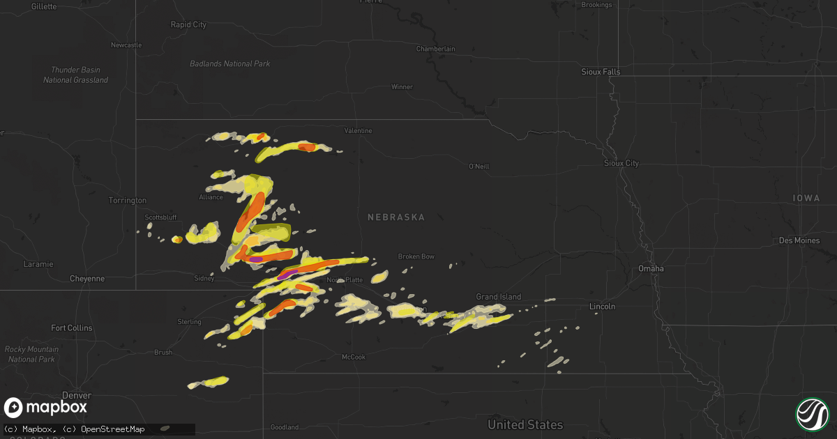
Hail Map in Nebraska on May 10, 2018
Get this storm
May 10 map
$229
one time, instant access
Download today. No call, no setup
Keep the $229
Bought the map and want the full workflow? Apply the entire $229 to a subscription within 7 days. None of it is wasted.
Every map, not just this one
This buys you this map. Subscription and you get every map we run, in the markets you choose from a few cities to whole states to nationwide. Plus real-time alerts the moment a storm fires.
Contact data
Name, contact info, occupancy, even credit band for addresses in the footprint. You go from where it hit to who to call.
Become the source they trust
Unlimited branding weather history reports on demand. You already have the documented answer ready for the property owner, and you are the one who showed up with it.
Property data and RoofTrace estimates
Pull up any address you have got, its value and the exact code rules for that jurisdiction, straight from One Click Code. Then RoofTrace estimates the squares, pitch, and roof value, priced the way you price.
Storm reports in Nebraska
Nebraska
| Date | Description |
|---|---|
| 05/10/20186:35 PM CDT | A local report indicates 1.25 inch wind near 17 S CODY |
| 05/10/20186:32 PM CDT | A local report indicates 1.00 inch wind near 19 N ELLSWORTH |
| 05/10/20186:30 PM CDT | Two large trees down. One fell on a pickup truck... Another is blocking the road. |
| 05/10/20186:17 PM CDT | Reports of irrigation pivot overturned... Metal roof torn from a building. Also at about 1710l we recieved a report of a truck blow over in alden about 4 miles to the s |
| 05/10/20186:13 PM CDT | A local report indicates 1.00 inch wind near 2 E GORDON |
| 05/10/20186:13 PM CDT | Public reported a semi blow over due to strong tstm winds |
| 05/10/20186:13 PM CDT | A local report indicates 1.25 inch wind near 16 SW CODY |
| 05/10/20186:10 PM CDT | Golf ball size hail and 40 to 50 mph winds. |
| 05/10/20186:08 PM CDT | Delayed report |
| 05/10/20186:00 PM CDT | Reported along hwy 385 |
| 05/10/20186:00 PM CDT | Estimated to have been 50 to 60 mph. |
| 05/10/20185:58 PM CDT | A local report indicates 64 MPH wind near CRESCENT LAKE NWR |
| 05/10/20185:50 PM CDT | Report via social media. |
| 05/10/20185:40 PM CDT | A local report indicates 1.50 inch wind near 17 E HARRISBURG |
| 05/10/20185:11 PM CDT | A local report indicates 1.00 inch wind near 22 SE GORDON |
| 05/10/20184:50 PM CDT | Report via social media. |
| 05/10/20184:40 PM CDT | A local report indicates 1.75 inch wind near 6 E GORDON |
| 05/10/20186:59 AM CDT | At 1159 PM CDT, severe thunderstorms were located along a line extending from near Comstock to 9 miles northeast of Sumner, moving east at 40 mph. HAZARD...60 mph wind gusts. SOURCE...Radar indicated. IMPACT...Expect damage to roofs, siding, and trees. Locations impacted include... Ansley, Mason City, Comstock, Westerville, Buckeye, Block Hill Basin, Arcadia Diversion Dam State Wildlife Management Area, Burr Oak, Gavin Siding, Wescott, Cumro and Intersection of Highway 183 and Cumro Road.This includes the following highways... Highway 183 between mile markers 73 and 100. Highway 2 between mile markers 289 and 307. Highway 92 between mile markers 300 and 308. |
| 05/10/20186:44 AM CDT | At 1143 PM CDT, severe thunderstorms were located along a line extending from Litchfield to near Overton to 7 miles southwest of Eustis, moving east at 20 mph. HAZARD...70 mph wind gusts. SOURCE...Trained weather spotters and automated weather observing equipment . IMPACT...Expect considerable tree damage. Damage is likely to mobile homes, roofs, and outbuildings. Locations impacted include... Kearney, Lexington, Cozad, Ravenna, Loup City, Elm Creek, Bertrand, Elwood, Overton, Odessa, Pleasanton, Litchfield, Amherst, Sumner, Ashton, Riverdale, Miller, Rockville, Eddyville and Hazard.This includes Interstate 80 between mile markers 214 and 281. |
| 05/10/20186:25 AM CDT | At 1124 PM CDT, severe thunderstorms were located along a line extending from 6 miles southeast of Ravenna to near Elm Creek, moving east at 45 mph. HAZARD...70 mph wind gusts. SOURCE...Radar indicated. IMPACT...Expect considerable tree damage. Damage is likely to mobile homes, roofs, and outbuildings. Locations impacted include... Curtis, Brady, Eustis, Maxwell, Moorefield, Maywood, Cottonwood Canyon State Wildlife Management Area, Hansen Memorial Reserve State Wildlife Management Area, Jeffrey Canyon State Wildlife Management Area, Vroman and Dancing Leaf Earth Lodge.This includes the following highways... Interstate 80 in Nebraska between mile markers 187 and 207. Highway 83 between mile markers 40 and 48. |
| 05/10/20186:13 AM CDT | At 1112 PM CDT, severe thunderstorms were located along a line extending from 6 miles north of Eddyville to near Cozad to 8 miles northeast of Wellfleet, moving east at 45 mph. HAZARD...70 mph wind gusts and nickel size hail. SOURCE...Radar indicated. IMPACT...Expect considerable tree damage. Damage is likely to mobile homes, roofs, and outbuildings. Locations impacted include... Lexington, Cozad, Gothenburg, Overton, Sumner, Eddyville, Willow Island and Farnam.This includes Interstate 80 between mile markers 209 and 249. |
| 05/10/20186:01 AM CDT | At 1100 PM CDT, severe thunderstorms were located along a line extending from near Pleasanton to near Johnson Lake, moving east at 45 mph. HAZARD...70 mph wind gusts. SOURCE...Radar indicated. IMPACT...Expect considerable tree damage. Damage is likely to mobile homes, roofs, and outbuildings. Locations impacted include... Brady, Maxwell, Wellfleet, Lake Maloney State Recreation Area, Keith, Cottonwood Canyon State Wildlife Management Area, Hansen Memorial Reserve State Wildlife Management Area and Jeffrey Canyon State Wildlife Management Area.This includes the following highways... Interstate 80 in Nebraska between mile markers 184 and 207. Highway 83 between mile markers 52 and 78. |
| 05/10/20185:58 AM CDT | At 1057 PM CDT, severe thunderstorms were located along a line extending from near Taylor to near Berwyn to near Oconto, moving east at 25 mph. HAZARD...70 mph wind gusts and penny size hail. SOURCE...Radar indicated. IMPACT...Expect considerable tree damage. Damage is likely to mobile homes, roofs, and outbuildings. Locations impacted include... Broken Bow, Callaway, Sargent, Ansley, Merna, Mason City, Oconto, Comstock, Berwyn, Weissert, Westerville, Lillian, Walworth, Lodi, Buckeye, Round Valley, Arcadia Diversion Dam State Wildlife Management Area, Burr Oak, Gavin Siding and Wescott.This includes the following highways... Highway 183 between mile markers 73 and 121. Highway 2 between mile markers 266 and 307. Highway 92 between mile markers 270 and 308. |
| 05/10/20185:57 AM CDT | At 1056 PM CDT, severe thunderstorms were located along a line extending from near Burwell to 6 miles northeast of Ansley to 11 miles east of Oconto to 6 miles west of Eddyville, moving east at 50 mph. HAZARD...60 mph wind gusts. SOURCE...Trained weather spotters and automated observing equipment IMPACT...Expect damage to roofs, siding, and trees. Locations impacted include... Ord, Ravenna, Loup City, Pleasanton, Arcadia, North Loup, Litchfield, Ashton, Miller, Rockville, Hazard, Elyria, Fort Hartsuff State Park and Sherman Reservoir Dam. |
| 05/10/20185:30 AM CDT | At 1030 PM MDT, a severe thunderstorm was located near Brule, or 8 miles southeast of Big Springs, moving northeast at 30 mph. HAZARD...Quarter size hail. SOURCE...Radar indicated. IMPACT...Damage to vehicles is expected. Locations impacted include... Ogallala, Brule, Keystone, Roscoe and Kingsley Dam. This includes the following highways... Highway 61 between mile markers 78 and 102. Highway 92 between mile markers 136 and 138. Interstate 80 in Nebraska between mile markers 112 and 139. |
| 05/10/20185:17 AM CDT | At 1016 PM CDT, severe thunderstorms were located along a line extending from near Callaway to 11 miles northeast of Brady to 11 miles south of Maxwell, moving east at 45 mph. HAZARD...60 mph wind gusts. SOURCE...Trained weather spotters. IMPACT...Expect damage to roofs, siding, and trees. Locations impacted include... Cozad, Gothenburg, Sumner, Eddyville and Willow Island. This storm has a history of wind gusts to over 60 mph across portions of Lincoln County.This includes Interstate 80 between mile markers 209 and 227. |
| 05/10/20185:13 AM CDT | At 1012 PM CDT/912 PM MDT/, severe thunderstorms were located along a line extending from 8 miles southeast of Sutherland Reservoir State Recreation Area to near Wallace, moving east at 25 mph. HAZARD...70 mph wind gusts and quarter size hail. SOURCE...Radar indicated. IMPACT...Hail damage to vehicles is expected. Expect considerable tree damage. Wind damage is also likely to mobile homes, roofs, and outbuildings. Locations impacted include... Wallace, Dickens, Grainton and Somerset. |
| 05/10/20185:09 AM CDT | At 1008 PM CDT, severe thunderstorms were located along a line extending from near Oconto to near Moorefield, moving east at 45 mph. HAZARD...70 mph wind gusts and penny size hail. SOURCE...Radar indicated. IMPACT...Expect considerable tree damage. Damage is likely to mobile homes, roofs, and outbuildings. Locations impacted include... Brady, Wellfleet, Hansen Memorial Reserve State Wildlife Management Area, Jeffrey Canyon State Wildlife Management Area and Vroman.This includes the following highways... Interstate 80 in Nebraska between mile markers 198 and 208. Highway 83 between mile markers 52 and 69. |
| 05/10/20185:05 AM CDT | At 1005 PM CDT, severe thunderstorms were located along a line extending from 8 miles north of Anselmo to 14 miles northeast of Brady, moving east at 20 mph. HAZARD...60 mph wind gusts and penny size hail. SOURCE...Radar indicated. IMPACT...Expect damage to roofs, siding, and trees. Locations impacted include... Broken Bow, Arnold, Callaway, Sargent, Ansley, Merna, Mason City, Oconto, Anselmo, Comstock, Berwyn, Victoria Springs State Recreation Area, Weissert, Westerville, Lillian, Milburn, Walworth, Lodi, Buckeye and Finchville.This includes the following highways... Highway 183 between mile markers 73 and 121. Highway 2 between mile markers 246 and 307. Highway 92 between mile markers 246 and 308. |
| 05/10/20184:41 AM CDT | At 940 PM CDT, severe thunderstorms were located along a line extending from 8 miles south of Gandy to near Lake Maloney State Recreation Area, moving northeast at 40 mph. HAZARD...60 mph wind gusts and penny size hail. SOURCE...Radar indicated. IMPACT...Expect damage to roofs, siding, and trees. Locations impacted include... North Platte, Hershey, Brady, Maxwell, Lake Maloney State Recreation Area, North Platte Airport, Keith, Cottonwood Canyon State Wildlife Management Area and Birdwood.This includes the following highways... Highway 97 between mile markers 1 and 14. Interstate 80 in Nebraska between mile markers 165 and 197. Highway 83 between mile markers 70 and 103. |
| 05/10/20184:28 AM CDT | At 928 PM CDT/828 PM MDT/, a severe thunderstorm was located near Elsie, or 13 miles east of Grant, moving east at 25 mph. HAZARD...Ping pong ball size hail and 60 mph wind gusts. SOURCE...Radar indicated. IMPACT...People and animals outdoors will be injured. Expect hail damage to roofs, siding, windows, and vehicles. Expect wind damage to roofs, siding, and trees. Locations impacted include... Wallace, Elsie and Grainton. |
| 05/10/20183:47 AM CDT | At 847 PM CDT/747 PM MDT/, severe thunderstorms were located along a line extending from 10 miles north of Seneca to near Thedford to 14 miles north of Ringgold, moving east at 55 mph. HAZARD...70 mph wind gusts. SOURCE...Radar indicated. IMPACT...Expect considerable tree damage. Damage is likely to mobile homes, roofs, and outbuildings. Locations impacted include... Thedford, Halsey, Gandy, Logan, Highway 83 crossing The Dismal River, Tarboz Lake, Shanklin Bluff, Hoagland, Brown Lake, Norway, Giant Hill and Natwick.This includes the following highways... Highway 2 between mile markers 198 and 227. Highway 92 between mile markers 242 and 245. Highway 83 between mile markers 113 and 161. |
| 05/10/20183:29 AM CDT | At 829 PM CDT/729 PM MDT/, a severe thunderstorm was located 7 miles south of Paxton, or 17 miles southeast of Ogallala, moving east at 25 mph. HAZARD...Ping pong ball size hail and 60 mph wind gusts. SOURCE...Radar indicated. IMPACT...People and animals outdoors will be injured. Expect hail damage to roofs, siding, windows, and vehicles. Expect wind damage to roofs, siding, and trees. Locations impacted include... Sutherland, Hershey, Paxton, Sutherland Reservoir State Recreation Area, Sarben, Coker, O'Fallons and Nevens.This includes Interstate 80 in Nebraska between mile markers 139 and169. |
| 05/10/20183:16 AM CDT | At 816 PM CDT/716 PM MDT/, severe thunderstorms were located along a line extending from 10 miles southwest of Mullen to 22 miles southeast of Whitman to 20 miles northeast of Arthur, moving southeast at 50 mph. HAZARD...60 mph wind gusts. SOURCE...Radar indicated. IMPACT...Expect damage to roofs, siding, and trees. Locations impacted include... Tryon, Ringgold, Sand Beach Lake, Highway 97 crossing the Dismal River, Big Lamunyon Flats, Hecla, East Cody Lake and Shimmons Lake.This includes the following highways... Highway 2 between mile markers 171 and 179. Highway 92 between mile markers 191 and 223. Highway 97 between mile markers 18 and 65. |
| 05/10/20183:00 AM CDT | A local report indicates 1.00 inch wind near 1 SSE KEARNEY |
| 05/10/20182:42 AM CDT | At 741 PM MDT, a severe thunderstorm was located over Grant, moving northeast at 20 mph. HAZARD...60 mph wind gusts and half dollar size hail. SOURCE...Radar indicated. IMPACT...Hail damage to vehicles is expected. Expect wind damage to roofs, siding, and trees. This severe thunderstorm will be near, Madrid around 805 PM MDT. Other locations impacted by this severe thunderstorm include WildHorse Spring.This includes Highway 61 between mile markers 56 and 74. |
| 05/10/20182:32 AM CDT | At 732 PM MDT, a severe thunderstorm was located 6 miles west of Amherst, or 6 miles north of Holyoke, moving northeast at 30 mph. HAZARD...Ping pong ball size hail and 60 mph wind gusts. SOURCE...Radar indicated. IMPACT...People and animals outdoors will be injured. Expect hail damage to roofs, siding, windows, and vehicles. Expect wind damage to roofs, siding, and trees. Locations impacted include... Holyoke, Paoli, Amherst and Pleasant Valley. |
| 05/10/20182:17 AM CDT | Dimes... Nickels a few quarter sized. |
| 05/10/20182:11 AM CDT | At 711 PM CDT/611 PM MDT/, a severe thunderstorm was located over Merritt Reservoir, or 23 miles southwest of Valentine, moving east at 25 mph. HAZARD...Half dollar size hail. SOURCE...Radar indicated. IMPACT...Damage to vehicles is expected. Locations impacted include... Valentine National Wildlife Refuge, Merritt Reservoir, Big Alkali Lake State Wildlife Management Area and Schlagel Creek State Wildlife Management Area.This includes the following highways... Highway 20 near mile marker 210. Highway 97 between mile markers 106 and 124. Highway 83 between mile markers 185 and 202. |
| 05/10/20182:05 AM CDT | A local report indicates 1.75 inch wind near 8 NW HERSHEY |
| 05/10/20182:05 AM CDT | At 705 PM MDT, a severe thunderstorm was located 9 miles east of Venango, or 11 miles southwest of Grant, moving northeast at 35 mph. HAZARD...Ping pong ball size hail and 60 mph wind gusts. SOURCE...Radar indicated. IMPACT...People and animals outdoors will be injured. Expect hail damage to roofs, siding, windows, and vehicles. Expect wind damage to roofs, siding, and trees. This severe thunderstorm will be near, Grant around 725 PM MDT. Madrid around 740 PM MDT. Elsie around 745 PM MDT. Other locations impacted by this severe thunderstorm include Brandonand Wild Horse Spring.This includes Highway 61 between mile markers 51 and 76. |
| 05/10/20182:04 AM CDT | Pea size hail was also occurring. |
| 05/10/20181:58 AM CDT | At 658 PM MDT, a severe thunderstorm was located near Lewellen, or 12 miles east of Oshkosh, moving east at 30 mph. HAZARD...Golf ball size hail and 70 mph wind gusts. SOURCE...Radar indicated. IMPACT...People and animals outdoors will be injured. Expect hail damage to roofs, siding, windows, and vehicles. Expect considerable tree damage. Wind damage is also likely to mobile homes, roofs, and outbuildings. Locations impacted include... Arthur, Lewellen, Lemoyne, Ash Hollow State Historical Park, Ruthon, Haythorn Lake, Belmar, Clear Creek State Wildlife Management Area, Bluewater Battlefield State Historical Park, McKeag and Otter Creek Campground.This includes the following highways... Highway 61 between mile markers 101 and 126. Highway 92 between mile markers 115 and 132, and between milemarkers 165 and 172. |
| 05/10/20181:56 AM CDT | A local report indicates 63 MPH wind near 3 S GENEVA |
| 05/10/20181:54 AM CDT | Corrects previous tstm wnd gst report from 3 sse bradshaw. |
| 05/10/20181:54 AM CDT | York awos. |
| 05/10/20181:52 AM CDT | A local report indicates 62 MPH wind near 1 W MILLIGAN |
| 05/10/20181:51 AM CDT | A local report indicates 60 MPH wind near 4 NE SHICKLEY |
| 05/10/20181:44 AM CDT | A local report indicates 65 MPH wind near 3 NW SHICKLEY |
| 05/10/20181:42 AM CDT | At 642 PM MDT, a severe thunderstorm was located near Brule, or 7 miles southwest of Ogallala, moving northeast at 20 mph. HAZARD...Golf ball size hail and 60 mph wind gusts. SOURCE...Radar indicated. IMPACT...People and animals outdoors will be injured. Expect hail damage to roofs, siding, windows, and vehicles. Expect wind damage to roofs, siding, and trees. This severe thunderstorm will be near, Ogallala around 705 PM MDT. Roscoe around 715 PM MDT. Keystone around 725 PM MDT. Other locations impacted by this severe thunderstorm includeBroganville.This includes the following highways... Highway 61 between mile markers 73 and 95. Interstate 80 in Nebraska between mile markers 117 and 143. |
| 05/10/20181:35 AM CDT | Delayed report. Peak gust of 58 mph per 20-minute obs. |
| 05/10/20181:32 AM CDT | At 632 PM MDT, a severe thunderstorm was located 9 miles southeast of Highland Center, or 11 miles southwest of Holyoke, moving east at 30 mph. HAZARD...Ping pong ball size hail and 60 mph wind gusts. SOURCE...Radar indicated. IMPACT...People and animals outdoors will be injured. Expect hail damage to roofs, siding, windows, and vehicles. Expect wind damage to roofs, siding, and trees. Locations impacted include... Holyoke and Pleasant Valley. |
| 05/10/20181:30 AM CDT | A local report indicates 60 MPH wind near AURORA |
| 05/10/20181:29 AM CDT | At 628 PM CDT/528 PM MDT/, a severe thunderstorm was located 9 miles east of Medicine Lake, or 38 miles west of Valentine, moving east at 30 mph. HAZARD...Two inch hail. SOURCE...Radar indicated. IMPACT...People and animals outdoors will be injured. Expect damage to roofs, siding, windows, and vehicles. Locations impacted include... Merritt Reservoir, Schoolhouse Lake, Steer Creek Campground and Anderson Bridge State Wildlife Management Area.This includes Highway 97 between mile markers 107 and 121. |
| 05/10/20181:27 AM CDT | At 626 PM MDT, a severe thunderstorm was located 17 miles southeast of Crescent Lake National Wildlife Refuge, or 19 miles northeast of Oshkosh, moving northeast at 40 mph. HAZARD...70 mph wind gusts and ping pong ball size hail. SOURCE...Radar indicated. IMPACT...People and animals outdoors will be injured. Expect hail damage to roofs, siding, windows, and vehicles. Expect considerable tree damage. Wind damage is also likely to mobile homes, roofs, and outbuildings. this severe thunderstorm will remain over mainly rural areas of northern Arthur...southwestern Grant and east central Garden Counties, including the following locations: Jensen Lake, Green Lake, Rackett, Bourquim Hill, Lena, Sand Puddin Lake, Three Mile Lake, Velma, Spring Valley Lake and Calora.This includes the following highways... Highway 61 between mile markers 126 and 155. Highway 92 between mile markers 165 and 168. |
| 05/10/20181:22 AM CDT | Corrects previous report from 4 ese inland. |
| 05/10/20181:20 AM CDT | A local report indicates 70 MPH wind near 3 W CLAY CENTER |
| 05/10/20181:20 AM CDT | Corrects previous report from 4 sw harvard. Mesonet station nb029... 4 sw harvard. |
| 05/10/20181:15 AM CDT | Six power poles were blown down on highway 6 between road h and road k. |
| 05/10/20181:13 AM CDT | Reports of at least two large trees down in central city along with damage to several smaller trees. |
| 05/10/20181:12 AM CDT | A local report indicates 62 MPH wind near 2 W GLENVIL |
| 05/10/20181:09 AM CDT | At 609 PM MDT, a severe thunderstorm was located 9 miles west of Oshkosh, moving east at 35 mph. HAZARD...Golf ball size hail and 70 mph wind gusts. SOURCE...Radar indicated. IMPACT...People and animals outdoors will be injured. Expect hail damage to roofs, siding, windows, and vehicles. Expect considerable tree damage. Wind damage is also likely to mobile homes, roofs, and outbuildings. This severe thunderstorm will be near, Oshkosh around 625 PM MDT. Lewellen around 640 PM MDT. Other locations impacted by this severe thunderstorm include AshHollow State Historical Park, Bluewater Battlefield State HistoricalPark, Windlass Hill and Intersection of Highway 27 and 9 Mile Road.This includes Highway 92 between mile markers 115 and 118. |
| 05/10/20181:07 AM CDT | Corrected to reflect a measured not estimated gust. |
| 05/10/20181:07 AM CDT | Delayed report of estimated 55-65 mph gusts with zero visibility in blowing dust. Relayed by em. |
| 05/10/20181:05 AM CDT | Corrects time of previous report for 1 ese doniphan. |
| 05/10/20181:02 AM CDT | Corrected again to reflect the actual peak gust speed of 64 mph at gri. |
| 05/10/20181:02 AM CDT | Pivot end blown over. Time estimated from radar. |
| 05/10/20181:01 AM CDT | A local report indicates 71 MPH wind near HASTINGS AIRPORT |
| 05/10/20181:00 AM CDT | At 600 PM MDT, a severe thunderstorm was located near Brule, or 8 miles southeast of Big Springs, moving northeast at 20 mph. HAZARD...Golf ball size hail. SOURCE...Radar indicated. IMPACT...People and animals outdoors will be injured. Expect damage to roofs, siding, windows, and vehicles. This severe thunderstorm will be near, Brule around 615 PM MDT. Ogallala around 645 PM MDT. Other locations impacted by this severe thunderstorm include Megeath.This includes the following highways... Highway 61 between mile markers 73 and 92. Interstate 80 in Nebraska between mile markers 110 and 132. |
| 05/10/20181:00 AM CDT | A local report indicates 2.50 inch wind near 4 N OGALLALA |
| 05/10/20181:00 AM CDT | Peak gust measured on davis weather station. |
| 05/10/20181:00 AM CDT | A local report indicates 70 MPH wind near 1 NW HASTINGS |
| 05/10/201812:59 AM CDT | This was the actual peak northwesterly gust of the event at hsi. |
| 05/10/201812:59 AM CDT | Corrects previous tstm wnd gst report from 3 ssw hastings. Zero visibility from blowing dust. |
| 05/10/201812:57 AM CDT | A local report indicates 60 MPH wind near 2 N HASTINGS |
| 05/10/201812:56 AM CDT | At 555 PM MDT, a severe thunderstorm was located 8 miles east of Ellsworth, or 38 miles east of Alliance, moving northeast at 25 mph. HAZARD...Two inch hail. SOURCE...Radar indicated. IMPACT...People and animals outdoors will be injured. Expect damage to roofs, siding, windows, and vehicles. Locations impacted include... Ashby, Watson Lake, Bingham, Duluth, Dipping Vat Meadow, Finnegan Lake, Intersection of Highway 61 and Survey Valley Road and Mother Lake.This includes the following highways... Highway 2 between mile markers 123 and 143, and between mile markers153 and 157. Highway 61 between mile markers 160 and 186. |
| 05/10/201812:55 AM CDT | Grand island asos. |
| 05/10/201812:50 AM CDT | A local report indicates 2.00 inch wind near 4 N OGALLALA |
| 05/10/201812:45 AM CDT | A local report indicates 70 MPH wind near HOLSTEIN |
| 05/10/201812:41 AM CDT | At 540 PM MDT, a severe thunderstorm was located 15 miles northeast of The Intersection Of Highway 385 And 92, or 22 miles south of Alliance, moving northeast at 30 mph. HAZARD...Golf ball size hail and 70 mph wind gusts. SOURCE...Radar indicated. IMPACT...People and animals outdoors will be injured. Expect hail damage to roofs, siding, windows, and vehicles. Expect considerable tree damage. Wind damage is also likely to mobile homes, roofs, and outbuildings. This severe thunderstorm will remain over mainly rural areas of southeastern Box Butte and northeastern Morrill Counties. |
| 05/10/201812:40 AM CDT | Corrects previous report from 2 nne norman. Unofficial peak gust from a personal weather station. |
| 05/10/201812:40 AM CDT | At 540 PM MDT, severe thunderstorms were located along a line extending from 13 miles east of Angora to 11 miles west of Crescent Lake National Wildlife Refuge to near Lisco, moving northeast at 35 mph. HAZARD...Golf ball size hail and 70 mph wind gusts. SOURCE...Radar indicated. IMPACT...People and animals outdoors will be injured. Expect hail damage to roofs, siding, windows, and vehicles. Expect considerable tree damage. Wind damage is also likely to mobile homes, roofs, and outbuildings. Locations impacted include... Lisco, Crescent Lake National Wildlife Refuge, Rackett, Dogtown Flats, Deer Lake, Britton Lake, Wild Horse Flats, Richardson Lake, Miles Lake, Mumper, Bourquim Hill, Herman Lake, Jerry Lake, Adams Flats, Sugar Loaf Hill and Tralnor Lake. |
| 05/10/201812:33 AM CDT | A local report indicates 78 MPH wind near 2 NNE NORMAN |
| 05/10/201812:22 AM CDT | At 521 PM MDT, a severe thunderstorm was located 9 miles east of Ellsworth, or 39 miles east of Alliance, moving north at 55 mph. HAZARD...Golf ball size hail and 70 mph wind gusts. SOURCE...Radar indicated. IMPACT...People and animals outdoors will be injured. Expect hail damage to roofs, siding, windows, and vehicles. Expect considerable tree damage. Wind damage is also likely to mobile homes, roofs, and outbuildings. Locations impacted include... Watson Lake, Bingham, Round Lake, Big Hill, Dipping Vat Meadow, Morgan Lake, Billys Lake, Wolf Hill, Finnegan Lake, Kennedy Lake, Intersection of Highway 61 and Survey Valley Road and Mother Lake.This includes the following highways... Highway 2 between mile markers 119 and 135. Highway 61 between mile markers 175 and 195. |
| 05/10/201812:21 AM CDT | A local report indicates 1.00 inch wind near 2 W KEARNEY |
| 05/10/201812:20 AM CDT | Corrects previous report from minden. Multiple social media pictures of downed branches in minden. Time estimated from radar. |
| 05/10/201812:20 AM CDT | Corrects previous report from 5 ne axtell. Nebraska mesonet station. |
| 05/10/201812:16 AM CDT | Unofficial gust from personal weather station. |
| 05/10/201812:10 AM CDT | Corrects previous report from mesonet station up018. |
| 05/10/201812:09 AM CDT | Kearney awos. |
| 05/10/201812:08 AM CDT | At 508 PM MDT, a severe thunderstorm was located over Gordon, moving east at 15 mph. HAZARD...Golf ball size hail. SOURCE...Radar indicated. IMPACT...People and animals outdoors will be injured. Expect damage to roofs, siding, windows, and vehicles. Locations impacted include... Gordon, Irwin, Intersection of Highway 20 and Irwin Road, Bayonne, Rock Hill and Intersection of Highway 27 and Mills Road.This includes Highway 20 between mile markers 101 and 131. |
| 05/10/201812:06 AM CDT | A local report indicates 64 MPH wind near 3 ESE KEARNEY |
| 05/10/201812:02 AM CDT | A local report indicates 61 MPH wind near 7 N FUNK |
| 05/10/201812:00 AM CDT | Corrected spelling error in previous comment. Peak gust obtained from dialing voice line in between standard 20-minute obs. |
| 05/10/201812:00 AM CDT | A local report indicates 65 MPH wind near 5 N HOLDREGE |
| 05/10/201812:00 AM CDT | Corrects previous report from 4 nne holdrege. Nebraska mesonet station. |
| 05/09/201811:58 PM CDT | At 458 PM MDT, a severe thunderstorm was located 10 miles north of Antioch, or 17 miles northeast of Alliance, moving east at 35 mph. HAZARD...Tennis ball size hail. SOURCE...Radar indicated. IMPACT...People and animals outdoors will be injured. Expect damage to roofs, siding, windows, and vehicles. Locations impacted include... Snow Lake, Watson Lake, Wickson Lake, Diamond Lake, Wolf Hill, Krause Lake, Argo Hill and Kennedy Lake.This includes Highway 250 between mile markers 4 and 21. |
| 05/09/201811:57 PM CDT | At 456 PM MDT, a severe thunderstorm was located near Crescent Lake National Wildlife Refuge, or 27 miles north of Oshkosh, moving northeast at 45 mph. HAZARD...Golf ball size hail and 70 mph wind gusts. SOURCE...Radar indicated. IMPACT...People and animals outdoors will be injured. Expect hail damage to roofs, siding, windows, and vehicles. Expect considerable tree damage. Wind damage is also likely to mobile homes, roofs, and outbuildings. Locations impacted include... Ellsworth, Hyannis, Ashby, Crescent Lake National Wildlife Refuge, Patterson Lake, Swede Lake, Deer Lake, Britton Lake, Kincaid Lake, Kennedy Lake, Wild Horse Flats, Snow Lake, Mumper, Bingham, Lakeside, Herman Lake, Dominick Lake, Jerry Lake and Adams Flats.This includes the following highways... Highway 250 between mile markers 1 and 8. Highway 2 between mile markers 107 and 146. Highway 61 near mile marker 159. |
| 05/09/201811:55 PM CDT | A local report indicates 60 MPH wind near LOUP CITY |
| 05/09/201811:50 PM CDT | At 449 PM MDT, a severe thunderstorm was located 10 miles west of Medicine Lake, or 29 miles east of Gordon, moving northeast at 25 mph. HAZARD...Tennis ball size hail. SOURCE...Radar indicated. IMPACT...People and animals outdoors will be injured. Expect damage to roofs, siding, windows, and vehicles. Locations impacted include... Cody, Medicine Lake, Indian Hill, Intersection of Highway 61 and Shadbolt Road, Schoolhouse Lake and Highway 61 crossing the Snake River.This includes the following highways... Highway 20 between mile markers 151 and 158. Highway 61 between mile markers 197 and 211. |
| 05/09/201811:48 PM CDT | At 448 PM MDT, a severe thunderstorm was located over Redington, or 25 miles southeast of Scottsbluff, moving east at 40 mph. HAZARD...60 mph wind gusts and quarter size hail. SOURCE...Radar indicated. IMPACT...Hail damage to vehicles is expected. Expect wind damage to roofs, siding, and trees. Locations impacted include... Bridgeport, Northport, The Intersection Of Highway 385 And 92, Chimney Rock State Park, Court House And Jail Rocks, Bridgeport State Recreation Area, Redington, South Bayard Junction and Broadwater. |
| 05/09/201811:41 PM CDT | At 438 PM MDT, a severe thunderstorm was located 8 miles west of Oshkosh, moving northeast at 35 mph. HAZARD...Golf ball size hail and 60 mph wind gusts. SOURCE...Radar indicated. IMPACT...People and animals outdoors will be injured. Expect hail damage to roofs, siding, windows, and vehicles. Expect wind damage to roofs, siding, and trees. Locations impacted include... Oshkosh, Lewellen, Ash Hollow State Historical Park, Bluewater Battlefield State Historical Park, Windlass Hill and Intersection of Highway 27 and 9 Mile Road.This includes Highway 92 between mile markers 115 and 118. |
| 05/09/201811:41 PM CDT | At 440 PM MDT, a severe thunderstorm was located 6 miles south of Ovid, or 10 miles southwest of Julesburg, moving northeast at 30 mph. HAZARD...60 mph wind gusts and half dollar size hail. SOURCE...Radar indicated. IMPACT...Hail damage to vehicles is expected. Expect wind damage to roofs, siding, and trees. Locations impacted include... Julesburg and Ovid. |
| 05/09/201811:35 PM CDT | Corrects previous report from lexington airport. Peak gust at lxn per 20-minute obs. |
| 05/09/201811:29 PM CDT | A local report indicates 62 MPH wind near 4 SE MILLER |
| 05/09/201811:28 PM CDT | At 428 PM MDT, a severe thunderstorm was located 8 miles northeast of Wild Horse Butte, or 19 miles north of Alliance, moving northeast at 30 mph. HAZARD...Half dollar size hail. SOURCE...Radar indicated. IMPACT...Damage to vehicles is expected. Locations impacted include... Diamond Lake, Smith Lake State Wildlife Management Area, Argo Hill and Krause Lake.This includes Highway 250 between mile markers 16 and 37. |
| 05/09/201811:25 PM CDT | At 425 PM MDT, a severe thunderstorm was located near Lisco, or 11 miles west of Oshkosh, moving northeast at 45 mph. HAZARD...Ping pong ball size hail and 60 mph wind gusts. SOURCE...Radar indicated. IMPACT...People and animals outdoors will be injured. Expect hail damage to roofs, siding, windows, and vehicles. Expect wind damage to roofs, siding, and trees. Locations impacted include... Lisco, Crescent Lake National Wildlife Refuge, Richardson Lake, Mumper, Rackett, Dogtown Flats, Adams Flats and Sugar Loaf Hill. |
| 05/09/201811:18 PM CDT | At 418 PM MDT, a severe thunderstorm was located 7 miles north of Wild Horse Butte, or 18 miles north of Alliance, moving northeast at 25 mph. HAZARD...60 mph wind gusts and quarter size hail. SOURCE...Radar indicated. IMPACT...Hail damage to vehicles is expected. Expect wind damage to roofs, siding, and trees. Locations impacted include... Alliance, Wild Horse Butte and Berea. |
| 05/09/201811:15 PM CDT | Lexington awos. |
| 05/09/201811:01 PM CDT | A local report indicates 60 MPH wind near ANSLEY |
| 05/09/201811:00 PM CDT | A local report indicates 62 MPH wind near 2 NW GOTHENBURG |
| 05/09/201810:52 PM CDT | Outflow from storms to the east |
| 05/09/201810:35 PM CDT | A local report indicates 60 MPH wind near 8 SW CALLAWAY |
| 05/09/201810:34 PM CDT | At 333 PM MDT, a severe thunderstorm was located 18 miles south of Gordon, moving northeast at 35 mph. HAZARD...Half dollar size hail. SOURCE...Radar indicated. IMPACT...Damage to vehicles is expected. Locations impacted include... Merriman, Highway 61 Crossing The Niobrara River, Intersection of Highway 61 and Shadbolt Road, Rock Hill, Morgan Lake and Billys Lake.This includes the following highways... Highway 20 between mile markers 135 and 137. Highway 61 between mile markers 203 and 227. |
| 05/09/201810:32 PM CDT | A local report indicates 60 MPH wind near 6 N COZAD |
| 05/09/201810:28 PM CDT | A local report indicates 62 MPH wind near BROKEN BOW |
| 05/09/201810:10 PM CDT | A local report indicates 65 MPH wind near 10 SE NORTH PLATTE |
| 05/09/201810:09 PM CDT | Delayed report via social media. Public reported 90 mph gust on home weather station. |
| 05/09/201810:01 PM CDT | A local report indicates 58 MPH wind near 4 S NORTH PLATTE |
| 05/09/20189:48 PM CDT | Lee bird field asos still gusting 56kts |
| 05/09/20189:39 PM CDT | Klbf asos peak wind gust |
| 05/09/20188:58 PM CDT | Public report of a landspout tornado. |
| 05/09/20188:47 PM CDT | A local report indicates 1.75 inch wind near GRANT |
| 05/09/20188:42 PM CDT | A local report indicates 1.00 inch wind near GRANT |
| 05/09/20188:40 PM CDT | A local report indicates 1.75 inch wind near 7 S PAXTON |
| 05/09/20188:27 PM CDT | A local report indicates 1.25 inch wind near 6 S ROSCOE |
| 05/09/20188:24 PM CDT | A local report indicates 70 MPH wind near 8 S MULLEN |
| 05/09/20188:22 PM CDT | A local report indicates 70 MPH wind near 2 S MULLEN |
| 05/09/20188:07 PM CDT | A local report indicates 1.00 inch wind near 8 N ARTHUR |
| 05/09/20188:00 PM CDT | Time estimated from radar |
| 05/09/20187:59 PM CDT | A local report indicates 1.50 inch wind near LEWELLEN |
| 05/09/20187:48 PM CDT | A local report indicates 2.00 inch wind near 3 NW LEWELLEN |
| 05/09/20187:40 PM CDT | Estimated time of 640pm mdt or 740pm cdt. Had quarter size hail and lots of marble size hail. |
| 05/09/20187:02 PM CDT | A local report indicates 1.75 inch wind near 12 NE OSHKOSH |
All States Impacted by Hail Map on May 10, 2018
Cities Impacted by Hail Map on May 10, 2018
- Elm Creek, NE
- Maywood, NE
- Curtis, NE
- Farnam, NE
- Moorefield, NE
- Tryon, NC
- Columbus, NC
- Mill Spring, NC
- Evansville, IN
- Brady, NE
- Stapleton, NE
- Arnold, NE
- Harrisburg, NE
- Shippensburg, PA
- Biglerville, PA
- Chambersburg, PA
- Lisco, NE
- Oshkosh, NE
- Palmyra, VA
- Mayodan, NC
- Buena Vista, VA
- Lakeside, NE
- Alliance, NE
- Ashby, NE
- Ellsworth, NE
- Bingham, NE
- Lincoln, NE
- Denton, NE
- Francisco, IN
- Dale, IN
- Lynnville, IN
- Chrisney, IN
- Tennyson, IN
- Boonville, IN
- Owensville, IN
- Elberfeld, IN
- Lamar, IN
- Lincoln City, IN
- Gentryville, IN
- Oakland City, IN
- Princeton, IN
- Grandview, IN
- Haubstadt, IN
- Patoka, IN
- Fort Branch, IN
- Campbellsville, KY
- Hillsborough, NC
- Efland, NC
- Hamilton, VA
- Purcellville, VA
- Harpers Ferry, WV
- Berryville, VA
- Waterford, VA
- Paeonian Springs, VA
- Round Hill, VA
- Bluemont, VA
- Lewellen, NE
- Holyoke, CO
- Venango, NE
- Amherst, CO
- Champion, NE
- Akron, CO
- Yuma, CO
- Elsie, NE
- Paxton, NE
- Ogallala, NE
- Lemoyne, NE
- Arthur, NE
- Bahama, NC
- Durham, NC
- Ashland, VA
- Mechanicsville, VA
- Walkerton, VA
- Merriman, NE
- Gordon, NE
- Monroe, VA
- Callaway, NE
- Gothenburg, NE
- Harrisburg, PA
- Hummelstown, PA
- Hershey, PA
- Williamston, NC
- Windsor, NC
- Plymouth, NC
- Jamesville, NC
- Palmer, TN
- Dunlap, TN
- Dunnsville, VA
- Lexington, NC
- Lewiston Woodville, NC
- Henderson, KY
- Bumpass, VA
- Beaverdam, VA
- Mineral, VA
- Louisa, VA
- Gettysburg, PA
- Overton, NE
- Robersonville, NC
- Elberon, VA
- Dendron, VA
- Ivor, VA
- Wakefield, VA
- Waverly, VA
- Windsor, VA
- Spring Grove, VA
- Smithfield, VA
- Blackstone, VA
- White Haven, PA
- Freeland, PA
- Connelly Springs, NC
- Midlothian, VA
- Richmond, VA
- Henrico, VA
- Nashville, TN
- Cody, NE
- Valentine, NE
- Hershey, NE
- Bremo Bluff, VA
- Henderson, NE
- Surry, VA
- Olney, IL
- Parkersburg, IL
- West Salem, IL
- Tryon, NE
- Sutherland, NE
- Keystone, NE
- Big Springs, NE
- North Platte, NE
- Brule, NE
- Rushville, NE
- Hay Springs, NE
- Rising Sun, MD
- Conowingo, MD
- Colora, MD
- Geneva, NE
- Burlington, NC
- Mebane, NC
- Rougemont, NC
- Franklinton, NC
- Creedmoor, NC
- Butner, NC
- Stem, NC
- Wake Forest, NC
- Cedar Grove, NC
- Hurdle Mills, NC
- Moravian Falls, NC
- Grant, NE
- Ovid, CO
- Sedgwick, CO
- Russell Springs, KY
- Rocky Mount, NC
- Nashville, NC
- Battleboro, NC
- Tunnel Hill, GA
- Rocky Face, GA
- Ringgold, GA
- Reisterstown, MD
- Woodbine, MD
- Sykesville, MD
- Finksburg, MD
- Westminster, MD
- Newburgh, IN
- Reed, KY
- Mount Vernon, IN
- Spottsville, KY
- Owensboro, KY
- Wadesville, IN
- Mount Airy, NC
- Gering, NE
- Columbia, KY
- Wellfleet, NE
- Maxwell, NE
- Lynchburg, VA
- Wood River, NE
- Alda, NE
- Doniphan, NE
- Pamplin, VA
- Charlottesville, VA
- Troy, VA
- North Garden, VA
- Keswick, VA
- Red House, VA
- Brookneal, VA
- Appomattox, VA
- Haxtun, CO
- Kearney, NE
- King And Queen Court House, VA
- Oconto, NE
- Goode, VA
- Bedford, VA
- Virginia Beach, VA
- Lewistown, PA
- Yeagertown, PA
- Burnham, PA
- Huntingdon, PA
- Petersburg, PA
- Belleville, PA
- Reedsville, PA
- Hastings, NE
- Cleveland, TN
- Tappahannock, VA
- Railroad, PA
- White Hall, MD
- East Berlin, PA
- Hanover, PA
- Pylesville, MD
- Glenville, PA
- Pleasant Hall, PA
- Orrstown, PA
- Aspers, PA
- Whiteford, MD
- Delta, PA
- Airville, PA
- Nottingham, PA
- Spring Grove, PA
- Darlington, MD
- Fawn Grove, PA
- New Freedom, PA
- Thomasville, PA
- New Park, PA
- Abbottstown, PA
- Stewartstown, PA
- Glen Rock, PA
- Seven Valleys, PA
- Felton, PA
- New Oxford, PA
- Port Deposit, MD
- Shrewsbury, PA
- York Springs, PA
- Street, MD
- La Follette, TN
- Lagrange, WY
- Gibbon, NE
- Nancy, KY
- Chesterfield, VA
- Church Road, VA
- Sutherland, VA
- Amelia Court House, VA
- Manakin Sabot, VA
- Rockville, VA
- Oilville, VA
- Glen Allen, VA
- Fairfield, IL
- Johnsonville, IL
- Cisne, IL
- Geff, IL
- Ford, VA
- Petersburg, VA
- Moseley, VA
- Charles Town, WV
- Ranson, WV
- Vale, NC
- Otis, CO
- Fleming, CO
- Spencer, VA
- Ridgeway, VA
- Juniata, NE
- Trumbull, NE
- Heartwell, NE
- Minden, NE
- Kenesaw, NE
- Litchfield, NE
- Loup City, NE
- Eustis, NE
- Chapel Hill, NC
- Reliance, TN
- Elwood, NE
- Lexington, NE
- Cozad, NE
- Timberlake, NC
- Montpelier, VA
- Shacklefords, VA
- Barhamsville, VA
- Westfield, NC
- Ararat, NC
- Pilot Mountain, NC
- Kenbridge, VA
- Upperville, VA
- Edmonton, KY
- Horse Cave, KY
- Greensburg, KY
- Hardyville, KY
- Center, KY
- Saint Stephens Church, VA
- Rawlings, VA
- McKenney, VA
- Ruther Glen, VA
- Doswell, VA
- Chappell, NE
- Lodgepole, NE
- East Bend, NC
- Yadkinville, NC
- Salisbury, NC
- Julesburg, CO
- Paoli, CO
- Thaxton, VA
- Suffolk, VA
- Bridgeport, WV
- Warsaw, VA
- Hanover, VA
- Aylett, VA
- Milford, VA
- Newtown, VA
- Strang, NE
- Bruning, NE
- Carleton, NE
- Hendersonville, NC
- Port Royal, PA
- Mifflin, PA
- Harrison, TN
- Iuka, IL
- Carrboro, NC
- Farmville, VA
- Mountain Top, PA
- Gandeeville, WV
- Forest City, NC
- Ellenboro, NC
- King William, VA
- West Point, VA
- Stevensville, VA
- Fort Oglethorpe, GA
- Rossville, GA
- Warrenton, VA
- Cynthiana, IN
- Thedford, NE
- Walnut Cove, NC
- Germanton, NC
- Bullock, NC
- Henderson, NC
- Oxford, NC
- New Harmony, IN
- Poseyville, IN
- Wallace, NE
- Madrid, NE
- Chase City, VA
- South Hill, VA
- Baskerville, VA
- Boydton, VA
- Bertrand, NE
- Loomis, NE
- Gladys, VA
- Altavista, VA
- Orma, WV
- Normantown, WV
- Patrick Springs, VA
- Bassett, VA
- Whitwell, TN
- Albin, WY
- Castalia, NC
- Whitakers, NC
- Fairmont, WV
- Monteagle, TN
- Tracy City, TN
- Huntington Mills, PA
- Shickshinny, PA
- Stillwater, PA
- Boonville, NC
- Buchanan, VA
- Axtell, NE
- Axton, VA
- Martinsville, VA
- Calhoun, IL
- Bridgeport, NE
- Broadwater, NE
- Bayard, NE
- Chadron, NE
- Enfield, NC
- Mount Erie, IL
- Eddyville, NE
- State Farm, VA
- Crozier, VA
- Maidens, VA
- Genoa, CO
- Limon, CO
- Hingham, MT
- Madison Heights, VA
- Whitman, NE
- Evington, VA
- Lynch Station, VA
- Hubbell, NE
- Hampton, VA
- Albany, KY
- Stony Point, NC
- Statesville, NC
- Tobyhanna, PA
- Cresco, PA
- Powhatan, VA
- Goochland, VA
- Sandy Hook, VA
- Little Plymouth, VA
- Manquin, VA
- Gum Spring, VA
- Hyannis, NE
- Fairbury, NE
- Spencer, WV
- Rutherfordton, NC
- Chester, NE
- Hebron, NE
- Gilead, NE
- Chester, VA
- Hardy, VA
- Boones Mill, VA
- Landrum, SC
- Campobello, SC
- Saluda, NC
- Sidney, NE
- Munfordville, KY
- Milligan, NE
- Dillwyn, VA
- Alexandria, NE
- Grafton, WV
- Thornton, WV
- Dickens, NE
- Superior, NE
- Guide Rock, NE
- Charlotte Court House, VA
- Dalton, GA
- Columbia, VA
- Morgantown, WV
- North East, MD
- Elkton, MD
- Xenia, IL
- Wilmington, DE
- New Castle, DE
- Meadows Of Dan, VA
- Chatsworth, GA
- Aurora, NE
- Howardsville, VA
- Schuyler, VA
- Wingina, VA
- Buckingham, VA
- Broken Bow, NE
- Mount Airy, MD
- Kilmarnock, VA
- Angora, NE
- Monticello, KY
- Bronston, KY
- Somerset, KY
- Nebo, NC
- Morganton, NC
- Harvard, NE
- Pennsylvania Furnace, PA
- Spruce Creek, PA
- Chattanooga, TN
- Lake Harmony, PA
- Hiddenite, NC
- Monkton, MD
- Parkton, MD
- York, NE
- Waco, NE
- Burnside, KY
- Amherst, VA
- Benton, PA
- Cave City, KY
- Weatherly, PA
- Gruetli Laager, TN
- Coalmont, TN
- Roxboro, NC
- Cartersville, VA
- Arvonia, VA
- Scottsville, VA
- New Canton, VA
- Spring Hope, NC
- Taylorsville, NC
- State College, PA
- Pine Grove Mills, PA
- Muncy Valley, PA
- Gloucester, VA
- Bernardsville, NJ
- Valdese, NC
- Spindale, NC
- Bostic, NC
- New Vernon, NJ
- Green Village, NJ
- Basking Ridge, NJ
- Morristown, NJ
- Jarrettsville, MD
- Benton, TN
- Delano, TN
- Oak, NE
- Lovettsville, VA
- Boyce, VA
- Leesburg, VA
- Gildford, MT
- Griffin, IN
- Mendham, NJ
- Madison, NC
- Chickamauga, GA
- Forest, VA
- Ocoee, TN
- Afton, VA
- Big Island, VA
- Bealeton, VA
- Jeffersonton, VA
- Midland, VA
- Shickley, NE
- Concord, VA
- Dinwiddie, VA
- Carson, VA
- Halifax, PA
- Duncannon, PA
- Arrington, VA
- Gladstone, VA
- Shelton, NE
- New Kent, VA
- Water View, VA
- Mattaponi, VA
- Church View, VA
- Urbanna, VA
- Jamaica, VA
- Bruington, VA
- Abingdon, VA
- Bristol, TN
- Duff, TN
- Sequatchie, TN
- Pelham, TN
- Siler City, NC
- Chesnee, SC
- Chesapeake, VA
- Hixson, TN
- Forest Hill, MD
- Mount Carmel, IL
- Mammoth Cave, KY
- Cub Run, KY
- La Crosse, VA
- White Plains, VA
- Ebony, VA
- Brodnax, VA
- McVeytown, PA
- Granville, PA
- Hickory, NC
- Greentown, PA
- Bradfordsville, KY
- Giltner, NE
- Odessa, NE
- Grand Island, NE
- Holdrege, NE
- Funk, NE
- Courtland, VA
- Faber, VA
- Shipman, VA
- Lovingston, VA
- Prince George, VA
- Wilsons, VA
- Dewitt, VA
- Fort Lee, VA
- Disputanta, VA
- Elora, TN
- Munden, KS
- Belleville, KS
- Narka, KS
- Tobaccoville, NC
- Unityville, PA
- Ripley, WV
- Kenna, WV
- Gordonsville, VA
- Kents Store, VA
- McDonald, TN
- Apison, TN
- Ooltewah, TN
- Fort Stockton, TX
- Speedwell, TN
- Crete, NE
- Dorchester, NE
- Lookout Mountain, GA
- Wildwood, GA
- Signal Mountain, TN
- Danbury, NC
- Sandy Ridge, NC
- Halifax, NC
- Flintville, TN
- Kelso, TN
- Tellico Plains, TN
- Skipwith, VA
- Hayes Center, NE
- Buffalo Junction, VA
- Nelson, VA
- Clarksville, VA
- Prospect, VA
- Newport News, VA
- Lancaster, VA
- Raywick, KY
- Friend, NE
- Cheyenne, WY
- Phenix, VA
- Palmyra, PA
- Peach Bottom, PA
- Rockport, IN
- Richland, IN
- Glasgow, VA
- Crozet, VA
- Stuart, VA
- Hillsville, VA
- Roper, NC
- Bruceton Mills, WV
- Millville, WV
- Shenandoah Junction, WV


