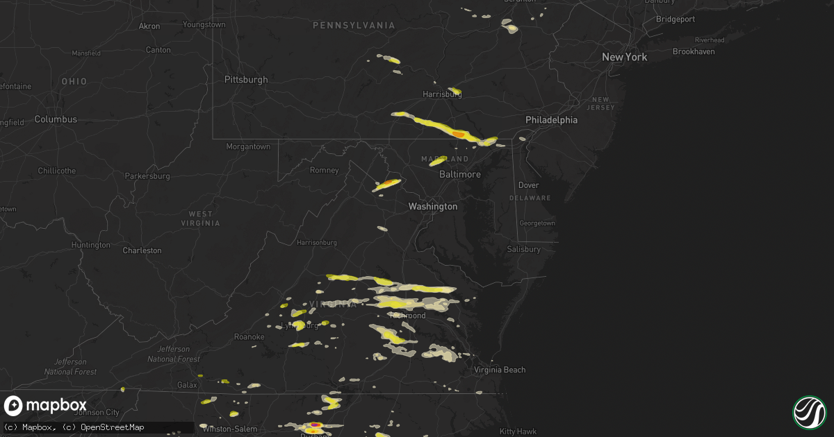
Hail Map in Maryland on May 10, 2018
Get this storm
May 10 map
$229
one time, instant access
Download today. No call, no setup
Keep the $229
Bought the map and want the full workflow? Apply the entire $229 to a subscription within 7 days. None of it is wasted.
Every map, not just this one
This buys you this map. Subscription and you get every map we run, in the markets you choose from a few cities to whole states to nationwide. Plus real-time alerts the moment a storm fires.
Contact data
Name, contact info, occupancy, even credit band for addresses in the footprint. You go from where it hit to who to call.
Become the source they trust
Unlimited branding weather history reports on demand. You already have the documented answer ready for the property owner, and you are the one who showed up with it.
Property data and RoofTrace estimates
Pull up any address you have got, its value and the exact code rules for that jurisdiction, straight from One Click Code. Then RoofTrace estimates the squares, pitch, and roof value, priced the way you price.
Storm reports in Maryland
Maryland
| Date | Description |
|---|---|
| 05/10/20185:40 PM CDT | A local report indicates 1.00 inch wind near WHITEFORD |
| 05/10/20184:33 PM CDT | A local report indicates 1.00 inch wind near 2 WNW GAMBER |
| 05/10/20181:51 AM CDT | At 651 PM EDT, a severe thunderstorm was located over Rising Sun, or 11 miles north of Havre De Grace, moving east at 30 mph. HAZARD...60 mph wind gusts and quarter size hail. SOURCE...Radar indicated. IMPACT...Minor damage to vehicles is possible. Wind damage to roofs, siding, trees, and power lines is possible. Locations impacted include... Elkton, Calvert, Oxford, North East, West Grove, Rising Sun, Charlestown, Glen Roy, Zion, Blake, Barksdale, West Nottingham, Octoraro, Mount Vernon, Fair Hill, Glen Westover, Bay View, Lombard, Richardsmere and Woodlawn. |
| 05/10/20181:37 AM CDT | At 636 PM EDT, a severe thunderstorm was located near Delta, or 15 miles northwest of Aberdeen, moving east at 30 mph. HAZARD...Ping pong ball size hail and 60 mph wind gusts. SOURCE...Radar indicated. IMPACT...Damaging winds will cause some trees and large branches to fall. This could injure those outdoors, as well as damage homes and vehicles. Roadways may become blocked by downed trees. Localized power outages are possible. Unsecured light objects may become projectiles. Locations impacted include... Aberdeen, Havre De Grace, Aberdeen Proving Ground, Bel Air North, Jarrettsville, Pylesville, Darlington, Cardiff, Churchville, Carsins, Scarboro, Chrome Hill, Street, Rocks, Hickory and Whiteford. |
| 05/10/20181:24 AM CDT | At 623 PM EDT, severe thunderstorms were located along a line extending from near Warrenton to 9 miles west of Bealeton to 7 miles northwest of Culpeper, moving southeast at 35 mph. HAZARD...60 mph wind gusts. SOURCE...Radar indicated. IMPACT...Damaging winds will cause some trees and large branches to fall. This could injure those outdoors, as well as damage homes and vehicles. Roadways may become blocked by downed trees. Localized power outages are possible. Unsecured light objects may become projectiles. Locations impacted include... Stafford, Fredericksburg, Culpeper, Warrenton, Quantico, Aquia Creek, Potomac Creek, Triangle, Dumfries, Bealeton, Massaponax, Spotsylvania, Cherry Hill, Falmouth, Opal, Remington, Catlett, Calverton, Midland and Brandy Station. |
| 05/10/201812:45 AM CDT | At 545 PM EDT, a severe thunderstorm was located near Codorus, or near Spry, moving east at 25 mph. HAZARD...60 mph wind gusts and quarter size hail. SOURCE...Radar indicated. IMPACT...Damaging winds will cause some trees and large branches to fall. This could injure those outdoors, as well as damage homes and vehicles. Roadways may become blocked by downed trees. Localized power outages are possible. Unsecured light objects may become projectiles. Locations impacted include... Havre De Grace, Pylesville, Darlington, Cardiff, Norrisville, Street, Rocks, Scarboro and Whiteford. |
| 05/10/201812:45 AM CDT | At 543 PM EDT, a severe thunderstorm was located over Glen Rock, moving east at 35 mph. HAZARD...60 mph wind gusts and quarter size hail. SOURCE...Radar indicated. IMPACT...Hail damage to vehicles is possible. Expect wind damage to trees and power lines. Locations impacted include... Dallastown, Red Lion, Spry, Brogue, Cross Roads, Sunnyburn, Shrewsbury, Glen Rock, Railroad and Jacobus.This includes Interstate 83 from mile markers 0 to 15. |
| 05/10/201812:17 AM CDT | At 517 PM EDT, a severe thunderstorm was located near Mount Airy, or 9 miles northeast of Damascus, moving east at 30 mph. HAZARD...60 mph wind gusts and quarter size hail. SOURCE...Radar indicated. IMPACT...Damaging winds will cause some trees and large branches to fall. This could injure those outdoors, as well as damage homes and vehicles. Roadways may become blocked by downed trees. Localized power outages are possible. Unsecured light objects may become projectiles. Locations impacted include... Baltimore, Pikesville, Cockeysville, Westminster, Ellicott City, Towson, Catonsville, Woodlawn, Randallstown, Parkville, Owings Mills, Eldersburg, Carney, Milford Mill, Reisterstown, Lochearn, Mays Chapel, Timonium, Mount Airy and Hampstead. |
| 05/10/201812:11 AM CDT | At 510 PM EDT, a severe thunderstorm was located over Hampton, moving east at 25 mph. HAZARD...60 mph wind gusts and quarter size hail. SOURCE...Radar indicated. IMPACT...Hail damage to vehicles is possible. Expect wind damage to trees and power lines. Locations impacted include... Hanover, York, Parkville, Spry, Weigelstown, West York, York Airport, Spring Grove, New Oxford and Lake Meade.This includes Interstate 83 from mile markers 10 to 18. |
| 05/09/201811:55 PM CDT | At 455 PM EDT, a severe thunderstorm was located over Millers Tavern, or near Tappahannock, moving east at 35 mph. HAZARD...60 mph wind gusts and quarter size hail. SOURCE...Radar indicated. IMPACT...Minor damage to vehicles is possible. Expect wind damage to trees and powerlines. This severe thunderstorm will be near, Tappahannock around 505 PM EDT. Dunnsville around 510 PM EDT. Warsaw and Center Cross around 515 PM EDT. Sharps around 520 PM EDT. Farnham and Haynesville around 525 PM EDT. Robley and Morattico around 530 PM EDT. Heathsville around 540 PM EDT. Lancaster around 545 PM EDT. Other locations impacted by this severe thunderstorm includeLottsburg, Regina, Avalon, Brook Vale, Upright, Nuttsville,Reedville, Belle Isle State Park, Biscoe and Edwardsville. |
| 05/09/201811:10 PM CDT | At 409 PM EDT, a severe thunderstorm was located over Bluemont, or 9 miles south of Charles Town, moving east at 25 mph. HAZARD...Tennis ball size hail and 60 mph wind gusts. SOURCE...Radar indicated. IMPACT...Expect wind damage to trees and power lines. Hail is large enough to dent and damage vehicles. Some hail damage to roofs, siding, and windows is possible. Locations impacted include... Purcellville, Brunswick, Lovettsville, Hillsboro, Paeonian Springs, Waterford, Neersville, Lucketts and Taylorstown. |
| 05/09/20189:32 PM CDT | At 232 PM EDT, a severe thunderstorm was located 7 miles northeast of Brookhaven, or 9 miles east of Morgantown, moving east at 20 mph. HAZARD...Wind gusts to 60 mph and quarter-size hail. SOURCE...Radar. IMPACT...Minor hail damage to vehicles is possible. Expect wind damage to trees and power lines, resulting in some power outages. Locations impacted include... Friendsville... Brookhaven... Markleysburg... Brandonville... Bruceton Mills... Valley Point... Laurel Run... Selbysport... Hazelton... Cranesville... Clifton Mills... Cheat Lake...This includes the following highways... Interstate 68 in Maryland between mile markers 1 and 5. Interstate 68 in West Virginia between mile markers 9 and 32. |
All States Impacted by Hail Map on May 10, 2018
Cities Impacted by Hail Map on May 10, 2018
- Elm Creek, NE
- Maywood, NE
- Curtis, NE
- Farnam, NE
- Moorefield, NE
- Tryon, NC
- Columbus, NC
- Mill Spring, NC
- Evansville, IN
- Brady, NE
- Stapleton, NE
- Arnold, NE
- Harrisburg, NE
- Shippensburg, PA
- Biglerville, PA
- Chambersburg, PA
- Lisco, NE
- Oshkosh, NE
- Palmyra, VA
- Mayodan, NC
- Buena Vista, VA
- Lakeside, NE
- Alliance, NE
- Ashby, NE
- Ellsworth, NE
- Bingham, NE
- Lincoln, NE
- Denton, NE
- Francisco, IN
- Dale, IN
- Lynnville, IN
- Chrisney, IN
- Tennyson, IN
- Boonville, IN
- Owensville, IN
- Elberfeld, IN
- Lamar, IN
- Lincoln City, IN
- Gentryville, IN
- Oakland City, IN
- Princeton, IN
- Grandview, IN
- Haubstadt, IN
- Patoka, IN
- Fort Branch, IN
- Campbellsville, KY
- Hillsborough, NC
- Efland, NC
- Hamilton, VA
- Purcellville, VA
- Harpers Ferry, WV
- Berryville, VA
- Waterford, VA
- Paeonian Springs, VA
- Round Hill, VA
- Bluemont, VA
- Lewellen, NE
- Holyoke, CO
- Venango, NE
- Amherst, CO
- Champion, NE
- Akron, CO
- Yuma, CO
- Elsie, NE
- Paxton, NE
- Ogallala, NE
- Lemoyne, NE
- Arthur, NE
- Bahama, NC
- Durham, NC
- Ashland, VA
- Mechanicsville, VA
- Walkerton, VA
- Merriman, NE
- Gordon, NE
- Monroe, VA
- Callaway, NE
- Gothenburg, NE
- Harrisburg, PA
- Hummelstown, PA
- Hershey, PA
- Williamston, NC
- Windsor, NC
- Plymouth, NC
- Jamesville, NC
- Palmer, TN
- Dunlap, TN
- Dunnsville, VA
- Lexington, NC
- Lewiston Woodville, NC
- Henderson, KY
- Bumpass, VA
- Beaverdam, VA
- Mineral, VA
- Louisa, VA
- Gettysburg, PA
- Overton, NE
- Robersonville, NC
- Elberon, VA
- Dendron, VA
- Ivor, VA
- Wakefield, VA
- Waverly, VA
- Windsor, VA
- Spring Grove, VA
- Smithfield, VA
- Blackstone, VA
- White Haven, PA
- Freeland, PA
- Connelly Springs, NC
- Midlothian, VA
- Richmond, VA
- Henrico, VA
- Nashville, TN
- Cody, NE
- Valentine, NE
- Hershey, NE
- Bremo Bluff, VA
- Henderson, NE
- Surry, VA
- Olney, IL
- Parkersburg, IL
- West Salem, IL
- Tryon, NE
- Sutherland, NE
- Keystone, NE
- Big Springs, NE
- North Platte, NE
- Brule, NE
- Rushville, NE
- Hay Springs, NE
- Rising Sun, MD
- Conowingo, MD
- Colora, MD
- Geneva, NE
- Burlington, NC
- Mebane, NC
- Rougemont, NC
- Franklinton, NC
- Creedmoor, NC
- Butner, NC
- Stem, NC
- Wake Forest, NC
- Cedar Grove, NC
- Hurdle Mills, NC
- Moravian Falls, NC
- Grant, NE
- Ovid, CO
- Sedgwick, CO
- Russell Springs, KY
- Rocky Mount, NC
- Nashville, NC
- Battleboro, NC
- Tunnel Hill, GA
- Rocky Face, GA
- Ringgold, GA
- Reisterstown, MD
- Woodbine, MD
- Sykesville, MD
- Finksburg, MD
- Westminster, MD
- Newburgh, IN
- Reed, KY
- Mount Vernon, IN
- Spottsville, KY
- Owensboro, KY
- Wadesville, IN
- Mount Airy, NC
- Gering, NE
- Columbia, KY
- Wellfleet, NE
- Maxwell, NE
- Lynchburg, VA
- Wood River, NE
- Alda, NE
- Doniphan, NE
- Pamplin, VA
- Charlottesville, VA
- Troy, VA
- North Garden, VA
- Keswick, VA
- Red House, VA
- Brookneal, VA
- Appomattox, VA
- Haxtun, CO
- Kearney, NE
- King And Queen Court House, VA
- Oconto, NE
- Goode, VA
- Bedford, VA
- Virginia Beach, VA
- Lewistown, PA
- Yeagertown, PA
- Burnham, PA
- Huntingdon, PA
- Petersburg, PA
- Belleville, PA
- Reedsville, PA
- Hastings, NE
- Cleveland, TN
- Tappahannock, VA
- Railroad, PA
- White Hall, MD
- East Berlin, PA
- Hanover, PA
- Pylesville, MD
- Glenville, PA
- Pleasant Hall, PA
- Orrstown, PA
- Aspers, PA
- Whiteford, MD
- Delta, PA
- Airville, PA
- Nottingham, PA
- Spring Grove, PA
- Darlington, MD
- Fawn Grove, PA
- New Freedom, PA
- Thomasville, PA
- New Park, PA
- Abbottstown, PA
- Stewartstown, PA
- Glen Rock, PA
- Seven Valleys, PA
- Felton, PA
- New Oxford, PA
- Port Deposit, MD
- Shrewsbury, PA
- York Springs, PA
- Street, MD
- La Follette, TN
- Lagrange, WY
- Gibbon, NE
- Nancy, KY
- Chesterfield, VA
- Church Road, VA
- Sutherland, VA
- Amelia Court House, VA
- Manakin Sabot, VA
- Rockville, VA
- Oilville, VA
- Glen Allen, VA
- Fairfield, IL
- Johnsonville, IL
- Cisne, IL
- Geff, IL
- Ford, VA
- Petersburg, VA
- Moseley, VA
- Charles Town, WV
- Ranson, WV
- Vale, NC
- Otis, CO
- Fleming, CO
- Spencer, VA
- Ridgeway, VA
- Juniata, NE
- Trumbull, NE
- Heartwell, NE
- Minden, NE
- Kenesaw, NE
- Litchfield, NE
- Loup City, NE
- Eustis, NE
- Chapel Hill, NC
- Reliance, TN
- Elwood, NE
- Lexington, NE
- Cozad, NE
- Timberlake, NC
- Montpelier, VA
- Shacklefords, VA
- Barhamsville, VA
- Westfield, NC
- Ararat, NC
- Pilot Mountain, NC
- Kenbridge, VA
- Upperville, VA
- Edmonton, KY
- Horse Cave, KY
- Greensburg, KY
- Hardyville, KY
- Center, KY
- Saint Stephens Church, VA
- Rawlings, VA
- McKenney, VA
- Ruther Glen, VA
- Doswell, VA
- Chappell, NE
- Lodgepole, NE
- East Bend, NC
- Yadkinville, NC
- Salisbury, NC
- Julesburg, CO
- Paoli, CO
- Thaxton, VA
- Suffolk, VA
- Bridgeport, WV
- Warsaw, VA
- Hanover, VA
- Aylett, VA
- Milford, VA
- Newtown, VA
- Strang, NE
- Bruning, NE
- Carleton, NE
- Hendersonville, NC
- Port Royal, PA
- Mifflin, PA
- Harrison, TN
- Iuka, IL
- Carrboro, NC
- Farmville, VA
- Mountain Top, PA
- Gandeeville, WV
- Forest City, NC
- Ellenboro, NC
- King William, VA
- West Point, VA
- Stevensville, VA
- Fort Oglethorpe, GA
- Rossville, GA
- Warrenton, VA
- Cynthiana, IN
- Thedford, NE
- Walnut Cove, NC
- Germanton, NC
- Bullock, NC
- Henderson, NC
- Oxford, NC
- New Harmony, IN
- Poseyville, IN
- Wallace, NE
- Madrid, NE
- Chase City, VA
- South Hill, VA
- Baskerville, VA
- Boydton, VA
- Bertrand, NE
- Loomis, NE
- Gladys, VA
- Altavista, VA
- Orma, WV
- Normantown, WV
- Patrick Springs, VA
- Bassett, VA
- Whitwell, TN
- Albin, WY
- Castalia, NC
- Whitakers, NC
- Fairmont, WV
- Monteagle, TN
- Tracy City, TN
- Huntington Mills, PA
- Shickshinny, PA
- Stillwater, PA
- Boonville, NC
- Buchanan, VA
- Axtell, NE
- Axton, VA
- Martinsville, VA
- Calhoun, IL
- Bridgeport, NE
- Broadwater, NE
- Bayard, NE
- Chadron, NE
- Enfield, NC
- Mount Erie, IL
- Eddyville, NE
- State Farm, VA
- Crozier, VA
- Maidens, VA
- Genoa, CO
- Limon, CO
- Hingham, MT
- Madison Heights, VA
- Whitman, NE
- Evington, VA
- Lynch Station, VA
- Hubbell, NE
- Hampton, VA
- Albany, KY
- Stony Point, NC
- Statesville, NC
- Tobyhanna, PA
- Cresco, PA
- Powhatan, VA
- Goochland, VA
- Sandy Hook, VA
- Little Plymouth, VA
- Manquin, VA
- Gum Spring, VA
- Hyannis, NE
- Fairbury, NE
- Spencer, WV
- Rutherfordton, NC
- Chester, NE
- Hebron, NE
- Gilead, NE
- Chester, VA
- Hardy, VA
- Boones Mill, VA
- Landrum, SC
- Campobello, SC
- Saluda, NC
- Sidney, NE
- Munfordville, KY
- Milligan, NE
- Dillwyn, VA
- Alexandria, NE
- Grafton, WV
- Thornton, WV
- Dickens, NE
- Superior, NE
- Guide Rock, NE
- Charlotte Court House, VA
- Dalton, GA
- Columbia, VA
- Morgantown, WV
- North East, MD
- Elkton, MD
- Xenia, IL
- Wilmington, DE
- New Castle, DE
- Meadows Of Dan, VA
- Chatsworth, GA
- Aurora, NE
- Howardsville, VA
- Schuyler, VA
- Wingina, VA
- Buckingham, VA
- Broken Bow, NE
- Mount Airy, MD
- Kilmarnock, VA
- Angora, NE
- Monticello, KY
- Bronston, KY
- Somerset, KY
- Nebo, NC
- Morganton, NC
- Harvard, NE
- Pennsylvania Furnace, PA
- Spruce Creek, PA
- Chattanooga, TN
- Lake Harmony, PA
- Hiddenite, NC
- Monkton, MD
- Parkton, MD
- York, NE
- Waco, NE
- Burnside, KY
- Amherst, VA
- Benton, PA
- Cave City, KY
- Weatherly, PA
- Gruetli Laager, TN
- Coalmont, TN
- Roxboro, NC
- Cartersville, VA
- Arvonia, VA
- Scottsville, VA
- New Canton, VA
- Spring Hope, NC
- Taylorsville, NC
- State College, PA
- Pine Grove Mills, PA
- Muncy Valley, PA
- Gloucester, VA
- Bernardsville, NJ
- Valdese, NC
- Spindale, NC
- Bostic, NC
- New Vernon, NJ
- Green Village, NJ
- Basking Ridge, NJ
- Morristown, NJ
- Jarrettsville, MD
- Benton, TN
- Delano, TN
- Oak, NE
- Lovettsville, VA
- Boyce, VA
- Leesburg, VA
- Gildford, MT
- Griffin, IN
- Mendham, NJ
- Madison, NC
- Chickamauga, GA
- Forest, VA
- Ocoee, TN
- Afton, VA
- Big Island, VA
- Bealeton, VA
- Jeffersonton, VA
- Midland, VA
- Shickley, NE
- Concord, VA
- Dinwiddie, VA
- Carson, VA
- Halifax, PA
- Duncannon, PA
- Arrington, VA
- Gladstone, VA
- Shelton, NE
- New Kent, VA
- Water View, VA
- Mattaponi, VA
- Church View, VA
- Urbanna, VA
- Jamaica, VA
- Bruington, VA
- Abingdon, VA
- Bristol, TN
- Duff, TN
- Sequatchie, TN
- Pelham, TN
- Siler City, NC
- Chesnee, SC
- Chesapeake, VA
- Hixson, TN
- Forest Hill, MD
- Mount Carmel, IL
- Mammoth Cave, KY
- Cub Run, KY
- La Crosse, VA
- White Plains, VA
- Ebony, VA
- Brodnax, VA
- McVeytown, PA
- Granville, PA
- Hickory, NC
- Greentown, PA
- Bradfordsville, KY
- Giltner, NE
- Odessa, NE
- Grand Island, NE
- Holdrege, NE
- Funk, NE
- Courtland, VA
- Faber, VA
- Shipman, VA
- Lovingston, VA
- Prince George, VA
- Wilsons, VA
- Dewitt, VA
- Fort Lee, VA
- Disputanta, VA
- Elora, TN
- Munden, KS
- Belleville, KS
- Narka, KS
- Tobaccoville, NC
- Unityville, PA
- Ripley, WV
- Kenna, WV
- Gordonsville, VA
- Kents Store, VA
- McDonald, TN
- Apison, TN
- Ooltewah, TN
- Fort Stockton, TX
- Speedwell, TN
- Crete, NE
- Dorchester, NE
- Lookout Mountain, GA
- Wildwood, GA
- Signal Mountain, TN
- Danbury, NC
- Sandy Ridge, NC
- Halifax, NC
- Flintville, TN
- Kelso, TN
- Tellico Plains, TN
- Skipwith, VA
- Hayes Center, NE
- Buffalo Junction, VA
- Nelson, VA
- Clarksville, VA
- Prospect, VA
- Newport News, VA
- Lancaster, VA
- Raywick, KY
- Friend, NE
- Cheyenne, WY
- Phenix, VA
- Palmyra, PA
- Peach Bottom, PA
- Rockport, IN
- Richland, IN
- Glasgow, VA
- Crozet, VA
- Stuart, VA
- Hillsville, VA
- Roper, NC
- Bruceton Mills, WV
- Millville, WV
- Shenandoah Junction, WV


