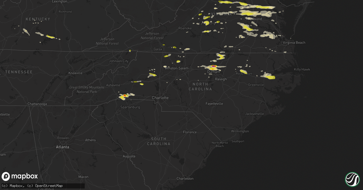
Hail Map in North Carolina on May 10, 2018
Get this storm
May 10 map
$229
one time, instant access
Download today. No call, no setup
Keep the $229
Bought the map and want the full workflow? Apply the entire $229 to a subscription within 7 days. None of it is wasted.
Every map, not just this one
This buys you this map. Subscription and you get every map we run, in the markets you choose from a few cities to whole states to nationwide. Plus real-time alerts the moment a storm fires.
Contact data
Name, contact info, occupancy, even credit band for addresses in the footprint. You go from where it hit to who to call.
Become the source they trust
Unlimited branding weather history reports on demand. You already have the documented answer ready for the property owner, and you are the one who showed up with it.
Property data and RoofTrace estimates
Pull up any address you have got, its value and the exact code rules for that jurisdiction, straight from One Click Code. Then RoofTrace estimates the squares, pitch, and roof value, priced the way you price.
Storm reports in North Carolina
North Carolina
| Date | Description |
|---|---|
| 05/10/20186:59 PM CDT | Thunderstorm winds downed a couple trees near deer run farm lane. |
| 05/10/20186:55 PM CDT | Quarter-sized hail on highway 64. |
| 05/10/20186:50 PM CDT | Many trees down in wingate and several trees down extending to marshville. A few powerlines down along the way as well. |
| 05/10/20186:49 PM CDT | Corrects previous tstm wnd dmg report from louisburg. Thunderstorm winds downed numerous trees within the community of lousiburg... Nc. |
| 05/10/20186:44 PM CDT | A local report indicates 1.00 inch wind near ROCKY MOUNT |
| 05/10/20186:42 PM CDT | Numerous trees down in pittsboro. |
| 05/10/20186:38 PM CDT | A few trees down starting in the city of monroe and extending east. |
| 05/10/20186:35 PM CDT | Tree down near the intersection of big oak church road and the intersection of nc highway 24/27. |
| 05/10/20186:20 PM CDT | Numerous trees down in siler city. |
| 05/10/20186:07 PM CDT | Numerous trees down in randolph county... Including one on the intersection of andrew hunter rd and faith rock rd. |
| 05/10/20185:49 PM CDT | Corrects previous tstm wnd dmg report from louisburg. Corrects previous tstm wnd dmg report from louisburg. Thunderstorm winds downed numerous trees within the communit |
| 05/10/20185:18 PM CDT | Ping pong size hail reported near the intersection of rose of sharon road and golden heather drive. Spotter reported hail damage to vehicles and trees. |
| 05/10/20185:16 PM CDT | Tree on a house on mitchell avenue. Tree down at jake alexander blvd and i-85. Another tree down on sunset drive. Time estimated based on radar. |
| 05/10/20185:04 PM CDT | Tree down on cedarwood st near nocarva rd. |
| 05/10/20184:58 PM CDT | Tree down near intersection of coleman road and cole farm road. |
| 05/10/20184:46 PM CDT | Multiple trees down on hicksboro road. |
| 05/10/20184:45 PM CDT | Trees down on highway 150. |
| 05/10/20184:45 PM CDT | Multiple trees down along piney grove road. |
| 05/10/20184:25 PM CDT | Golf ball size hail reported at stagville and bahama road. |
| 05/10/20184:23 PM CDT | Two trees blown down along grassy creek road near the bullock community. |
| 05/10/20184:21 PM CDT | Numerous trees down some blocking roads from near forest city to ellenboro. |
| 05/10/20184:05 PM CDT | Trees down on i-26... One on a tractor-trailer. Interstate is shut down. |
| 05/10/20183:50 PM CDT | Trees down. |
| 05/10/20183:50 PM CDT | Mostly nickel hail but some bigger. |
| 05/10/20183:35 PM CDT | Interstate 40 closed in both directions due to powerlines down at exit 111. |
| 05/10/20183:34 PM CDT | Hail fell at nc highway 89 north of walnut cove. |
| 05/10/20183:15 PM CDT | Spotter reported up to 1 inch hail north of cooksville... Nc. |
| 05/10/20183:08 PM CDT | Hail at least the size of quarters. |
| 05/10/20182:58 PM CDT | Quarter size hail at the tryon international equestrian center. |
| 05/10/20182:55 PM CDT | A school soccer team bus was hit by quarter to golf ball size hail while traveling along highway 74. |
| 05/10/20182:48 PM CDT | Power lines down in the forbush area just east of yadkinville. Per twitter. |
| 05/10/20182:42 PM CDT | Several trees blown down. |
| 05/10/20182:42 PM CDT | Quarter sized sized hail. |
| 05/10/20181:44 PM CDT | Facebook report. Time estimated from radar. |
| 05/10/20181:05 PM CDT | Nickel to quarter size hail at salem elementary school |
| 05/10/20181:05 PM CDT | Nickel to quarter size hail at salem elementary school |
| 05/10/20184:03 AM CDT | At 902 PM EDT, a severe thunderstorm was located 8 miles northwest of Hinson, or 8 miles east of Williamston, moving east at 35 mph. HAZARD...60 mph wind gusts and quarter size hail. SOURCE...Radar indicated. IMPACT...Hail damage to vehicles is expected. Expect wind damage to roofs, siding, and trees. Locations impacted include... Plymouth, Wenona, Hinson, Westover, Pleasant Grove, Scuppernong, Phelps Lake, Pungo Lake, Mackeys, Roper, Jamesville, Creswell and Dardens. |
| 05/10/20182:59 AM CDT | At 758 PM EDT, a severe thunderstorm was located near Pittsboro, moving east at 35 mph. HAZARD...60 mph wind gusts. SOURCE...Law enforcement. IMPACT...Expect damage to roofs, siding, and trees. Locations impacted include... Raleigh, Cary, Garner, Fuquay-Varina, Rdu International, Apex, Holly Springs, Morrisville, Lake Wheeler and New Hill. |
| 05/10/20182:40 AM CDT | At 739 PM EDT, a severe thunderstorm was located near Siler City, moving east at 35 mph. HAZARD...60 mph wind gusts and penny size hail. SOURCE...Radar indicated. IMPACT...Expect damage to roofs, siding, and trees. Locations impacted include... Pittsboro, Jordan Lake State Rec Area, Crosswinds Boating Center, Bynum, Seaforth Boat Dock, Crosswinds Campground, Moncure, Fearrington, Lake Jordan and Shearon Harris Reservoir. |
| 05/10/20182:35 AM CDT | At 735 PM EDT, severe thunderstorms were located along a line extending from near Dortches to near Nashville to near Bailey, moving east at 30 mph. HAZARD...60 mph wind gusts and nickel size hail. SOURCE...Radar indicated. IMPACT...Expect damage to roofs, siding, and trees. Locations impacted include... Rocky Mount, Tarboro, Nashville, Wilson, Elm City, Dortches, Bailey, Red Oak, Princeville and Sharpsburg. |
| 05/10/20182:33 AM CDT | At 733 PM EDT, a severe thunderstorm was located near Biscoe, or 7 miles northeast of Troy, moving east at 40 mph. HAZARD...60 mph wind gusts. SOURCE...Radar indicated. IMPACT...Expect damage to roofs, siding, and trees. Locations impacted include... Sanford, Carthage, Goldston, Seagrove, Broadway, Robbins, Cameron, Lemon Springs, Gum Springs and Harpers Crossroads. |
| 05/10/20182:14 AM CDT | At 713 PM EDT, a severe thunderstorm was located 10 miles northeast of Dortches, or 12 miles north of Rocky Mount, moving east at 35 mph. HAZARD...60 mph wind gusts and penny size hail. SOURCE...Radar indicated. IMPACT...Expect damage to roofs, siding, and trees. Locations impacted include... Scotland Neck, Dortches, Enfield, Whitakers, Hobgood, Glenview and Battleboro. |
| 05/10/20182:07 AM CDT | At 707 PM EDT, a severe thunderstorm was located near Asheboro, moving east at 35 mph. HAZARD...60 mph wind gusts and quarter size hail. SOURCE...Radar indicated. IMPACT...Hail damage to vehicles is expected. Expect wind damage to roofs, siding, and trees. Locations impacted include... Asheboro, Randleman, North Carolina Zoo, Siler City, Goldston, Liberty, Ramseur, Franklinville, Staley and Harpers Crossroads. |
| 05/10/20181:48 AM CDT | At 648 PM EDT, a severe thunderstorm was located near Abingdon, moving southeast at 30 mph. HAZARD...60 mph wind gusts and quarter size hail. SOURCE...Radar indicated. IMPACT...Hail damage to vehicles is expected. Expect wind damage to roofs, siding, and trees. Locations impacted include... Bristol Va, Abingdon, Mountain City, Damascus, Laurel Bloomery, Hilander Park, Harr, Shady Valley, Konnarock and Emory-Meadow View. |
| 05/10/20181:16 AM CDT | At 615 PM EDT, a severe thunderstorm was located near Franklinton, or near Louisburg, moving east at 30 mph. HAZARD...60 mph wind gusts and quarter size hail. SOURCE...Radar indicated. IMPACT...Hail damage to vehicles is expected. Expect wind damage to roofs, siding, and trees. Locations impacted include... Louisburg, Franklinton, Kittrell, Centerville and Ingleside. |
| 05/10/20181:08 AM CDT | At 608 PM EDT, a severe thunderstorm was located near Durham, moving east at 25 mph. HAZARD...60 mph wind gusts and quarter size hail. SOURCE...Radar indicated. IMPACT...Hail damage to vehicles is expected. Expect wind damage to roofs, siding, and trees. Locations impacted include... Raleigh, Durham, Hillsborough, Creedmoor, Butner, Lake Michie, Falls Lake State Rec Area, Eno River State Park, Gorman and Bahama. |
| 05/10/201812:43 AM CDT | At 541 PM EDT, a severe thunderstorm was located 11 miles south of Boydton, or 12 miles north of Henderson, moving east at 45 mph. HAZARD...60 mph wind gusts and quarter size hail. SOURCE...Radar indicated. IMPACT...Hail damage to vehicles is expected. Expect wind damage to roofs, siding, and trees. Locations impacted include... Henderson, Warrenton, Norlina, Littleton, Middleburg, Macon, Gillburg, Afton, South Henderson and Wise. |
| 05/10/201812:35 AM CDT | At 535 PM EDT, a severe thunderstorm was located near Boydton, or 16 miles south of Chase City, moving east at 40 mph. HAZARD...60 mph wind gusts and quarter size hail. SOURCE...Radar indicated. IMPACT...Minor damage to vehicles is possible. Expect wind damage to trees and powerlines. This severe thunderstorm will be near, La Crosse around 600 PM EDT. Brodnax around 605 PM EDT. Ebony around 610 PM EDT. Brunswick and Gasburg around 615 PM EDT. Other locations impacted by this severe thunderstorm includeBeechwood, Bowens Corner, Finchley, John H Kerr Dam, White Plains,Meredithville, Skipwith, Forksville, Rogers Corner and Richardson. |
| 05/10/201812:18 AM CDT | At 517 PM EDT, severe thunderstorms were located along a line extending from near Hitesburg to 8 miles southeast of Virgilina to 10 miles east of Roxboro, moving east at 40 mph. HAZARD...60 mph wind gusts and quarter size hail. SOURCE...Radar indicated. IMPACT...Hail damage to vehicles is expected. Expect wind damage to roofs, siding, and trees. Locations impacted include... Henderson, Oxford, Stovall, Middleburg, Gillburg, Steele Creek Marina & Campground, Kerr Lake, South Henderson, Dabney and Tungsten. |
| 05/10/201812:15 AM CDT | At 514 PM EDT, a severe thunderstorm was located 4 miles east of Statesville, moving east at 30 mph. HAZARD...60 mph wind gusts and quarter size hail. SOURCE...Radar indicated. IMPACT...Minor hail damage to vehicles is expected. Expect wind damage to trees and power lines. Locations impacted include... Salisbury, Statesville, Mocksville, Spencer, Granite Quarry, Rockwell, Cooleemee, Cleveland, Faith and Harmony. |
| 05/10/201812:12 AM CDT | At 512 PM EDT, a severe thunderstorm was located 6 miles south of Columbus, or near Landrum, moving southeast at 20 mph. HAZARD...60 mph wind gusts and quarter size hail. SOURCE...Radar indicated. IMPACT...Minor hail damage to vehicles is expected. Expect wind damage to trees and power lines. Locations impacted include... Boiling Springs SC, Landrum, Inman, Tryon, Campobello, Lake Bowen, USC Upstate, Gowensville, Fingerville and Saluda. |
| 05/10/201812:05 AM CDT | At 505 PM EDT, a severe thunderstorm was located near Rougemont, or 10 miles northeast of Hillsborough, moving east at 25 mph. HAZARD...60 mph wind gusts and quarter size hail. SOURCE...Radar indicated. IMPACT...Hail damage to vehicles is expected. Expect wind damage to roofs, siding, and trees. Locations impacted include... Oxford, Creedmoor, Butner, Rougemont, Stem, Lake Michie, Lake Butner, Moriah, Eno River State Park and Bahama. |
| 05/09/201811:34 PM CDT | At 434 PM EDT, a severe thunderstorm was located over Pine Hall, moving northeast at 45 mph. HAZARD...60 mph wind gusts and quarter size hail. SOURCE...Radar indicated. IMPACT...Hail damage to vehicles is expected. Expect wind damage to roofs, siding, and trees. Locations impacted include... Reidsville... Wentworth... Mayodan... Madison... and Walnut Cove. |
| 05/09/201811:31 PM CDT | At 430 PM EDT, a severe thunderstorm was located 5 miles east of Taylorsville, or near Stony Point, moving east at 20 mph. HAZARD...60 mph wind gusts and quarter size hail. SOURCE...Radar indicated. IMPACT...Minor hail damage to vehicles is expected. Expect wind damage to trees and power lines. Locations impacted include... Statesville, Taylorsville, Stony Point, Harmony, Love Valley, Hiddenite, Turnersburg, Olin, Vashti and Millersville. |
| 05/09/201811:27 PM CDT | At 426 PM EDT, severe thunderstorms were located along a line extending from Elmo to near Burlington, moving east at 65 mph. HAZARD...60 mph wind gusts and quarter size hail. SOURCE...Radar indicated. IMPACT...Hail damage to vehicles is expected. Expect wind damage to roofs, siding, and trees. Locations impacted include... Danville... Reidsville... South Boston... Yanceyville... and Bethel.This includes The following Location Danville Airport. |
| 05/09/201810:58 PM CDT | At 358 PM EDT, a severe thunderstorm was located 7 miles east of Columbus, moving east at 25 mph. HAZARD...60 mph wind gusts and quarter size hail. SOURCE...Radar indicated. IMPACT...Minor hail damage to vehicles is expected. Expect wind damage to trees and power lines. Locations impacted include... Forest City, Rutherfordton, Columbus, Spindale, Landrum, Tryon, Chesnee, Campobello, Lake Bowen and Mill Spring. |
| 05/09/201810:55 PM CDT | At 354 PM EDT, a severe thunderstorm was located 12 miles southeast of Morganton, or 7 miles east of South Mountains State Park, moving east at 25 mph. HAZARD...60 mph wind gusts and quarter size hail. SOURCE...Radar indicated. IMPACT...Minor hail damage to vehicles is expected. Expect wind damage to trees and power lines. Locations impacted include... Hickory, Newton, Lincolnton, Conover, Longview, Valdese, Maiden, Icard, Hildebran and Connelly Springs. |
| 05/09/20189:58 PM CDT | At 258 PM EDT, a severe thunderstorm was located near Maple Springs, moving east at 45 mph. HAZARD...60 mph wind gusts and quarter size hail. SOURCE...Radar indicated. IMPACT...Hail damage to vehicles is expected. Expect wind damage to roofs, siding, and trees. Locations impacted include... North Wilkesboro... Elkin... Wilkesboro... Yadkinville... and Jonesville. |
| 05/09/20189:15 PM CDT | At 215 PM EDT, a severe thunderstorm was located 8 miles northeast of Columbus, moving east at 25 mph. HAZARD...60 mph wind gusts and quarter size hail. SOURCE...Radar indicated. IMPACT...Minor hail damage to vehicles is expected. Expect wind damage to trees and power lines. Locations impacted include... Forest City, Rutherfordton, Spindale, Ellenboro, Bostic, Green Hill, Mill Spring, Henrietta, Harris and Lake Adger. |
| 05/09/20188:22 PM CDT | Trees down on long ridge road and highway 64. Time estimated by radar. |
| 05/09/20188:15 PM CDT | A local report indicates 1.00 inch wind near 4 S PLYMOUTH |
| 05/09/20188:10 PM CDT | Nickel to quarter size hail. |
| 05/09/20188:03 PM CDT | Tree down on cleveland road near intersection with short journey road. |
| 05/09/20187:53 PM CDT | Thunderstorm winds downed numerous trees within the community of lousiburg... Nc. |
| 05/09/20187:30 PM CDT | Swift creek fd is responding to a large tree down at lake wheeler rd. And inwood rd. |
| 05/09/20187:25 PM CDT | One tree down on jones franklin rd... Approximately half a mile from i-440. |
| 05/09/20187:01 PM CDT | Tree down on intersection of willett rd and peach orchard rd. |
All States Impacted by Hail Map on May 10, 2018
Cities Impacted by Hail Map on May 10, 2018
- Elm Creek, NE
- Maywood, NE
- Curtis, NE
- Farnam, NE
- Moorefield, NE
- Tryon, NC
- Columbus, NC
- Mill Spring, NC
- Evansville, IN
- Brady, NE
- Stapleton, NE
- Arnold, NE
- Harrisburg, NE
- Shippensburg, PA
- Biglerville, PA
- Chambersburg, PA
- Lisco, NE
- Oshkosh, NE
- Palmyra, VA
- Mayodan, NC
- Buena Vista, VA
- Lakeside, NE
- Alliance, NE
- Ashby, NE
- Ellsworth, NE
- Bingham, NE
- Lincoln, NE
- Denton, NE
- Francisco, IN
- Dale, IN
- Lynnville, IN
- Chrisney, IN
- Tennyson, IN
- Boonville, IN
- Owensville, IN
- Elberfeld, IN
- Lamar, IN
- Lincoln City, IN
- Gentryville, IN
- Oakland City, IN
- Princeton, IN
- Grandview, IN
- Haubstadt, IN
- Patoka, IN
- Fort Branch, IN
- Campbellsville, KY
- Hillsborough, NC
- Efland, NC
- Hamilton, VA
- Purcellville, VA
- Harpers Ferry, WV
- Berryville, VA
- Waterford, VA
- Paeonian Springs, VA
- Round Hill, VA
- Bluemont, VA
- Lewellen, NE
- Holyoke, CO
- Venango, NE
- Amherst, CO
- Champion, NE
- Akron, CO
- Yuma, CO
- Elsie, NE
- Paxton, NE
- Ogallala, NE
- Lemoyne, NE
- Arthur, NE
- Bahama, NC
- Durham, NC
- Ashland, VA
- Mechanicsville, VA
- Walkerton, VA
- Merriman, NE
- Gordon, NE
- Monroe, VA
- Callaway, NE
- Gothenburg, NE
- Harrisburg, PA
- Hummelstown, PA
- Hershey, PA
- Williamston, NC
- Windsor, NC
- Plymouth, NC
- Jamesville, NC
- Palmer, TN
- Dunlap, TN
- Dunnsville, VA
- Lexington, NC
- Lewiston Woodville, NC
- Henderson, KY
- Bumpass, VA
- Beaverdam, VA
- Mineral, VA
- Louisa, VA
- Gettysburg, PA
- Overton, NE
- Robersonville, NC
- Elberon, VA
- Dendron, VA
- Ivor, VA
- Wakefield, VA
- Waverly, VA
- Windsor, VA
- Spring Grove, VA
- Smithfield, VA
- Blackstone, VA
- White Haven, PA
- Freeland, PA
- Connelly Springs, NC
- Midlothian, VA
- Richmond, VA
- Henrico, VA
- Nashville, TN
- Cody, NE
- Valentine, NE
- Hershey, NE
- Bremo Bluff, VA
- Henderson, NE
- Surry, VA
- Olney, IL
- Parkersburg, IL
- West Salem, IL
- Tryon, NE
- Sutherland, NE
- Keystone, NE
- Big Springs, NE
- North Platte, NE
- Brule, NE
- Rushville, NE
- Hay Springs, NE
- Rising Sun, MD
- Conowingo, MD
- Colora, MD
- Geneva, NE
- Burlington, NC
- Mebane, NC
- Rougemont, NC
- Franklinton, NC
- Creedmoor, NC
- Butner, NC
- Stem, NC
- Wake Forest, NC
- Cedar Grove, NC
- Hurdle Mills, NC
- Moravian Falls, NC
- Grant, NE
- Ovid, CO
- Sedgwick, CO
- Russell Springs, KY
- Rocky Mount, NC
- Nashville, NC
- Battleboro, NC
- Tunnel Hill, GA
- Rocky Face, GA
- Ringgold, GA
- Reisterstown, MD
- Woodbine, MD
- Sykesville, MD
- Finksburg, MD
- Westminster, MD
- Newburgh, IN
- Reed, KY
- Mount Vernon, IN
- Spottsville, KY
- Owensboro, KY
- Wadesville, IN
- Mount Airy, NC
- Gering, NE
- Columbia, KY
- Wellfleet, NE
- Maxwell, NE
- Lynchburg, VA
- Wood River, NE
- Alda, NE
- Doniphan, NE
- Pamplin, VA
- Charlottesville, VA
- Troy, VA
- North Garden, VA
- Keswick, VA
- Red House, VA
- Brookneal, VA
- Appomattox, VA
- Haxtun, CO
- Kearney, NE
- King And Queen Court House, VA
- Oconto, NE
- Goode, VA
- Bedford, VA
- Virginia Beach, VA
- Lewistown, PA
- Yeagertown, PA
- Burnham, PA
- Huntingdon, PA
- Petersburg, PA
- Belleville, PA
- Reedsville, PA
- Hastings, NE
- Cleveland, TN
- Tappahannock, VA
- Railroad, PA
- White Hall, MD
- East Berlin, PA
- Hanover, PA
- Pylesville, MD
- Glenville, PA
- Pleasant Hall, PA
- Orrstown, PA
- Aspers, PA
- Whiteford, MD
- Delta, PA
- Airville, PA
- Nottingham, PA
- Spring Grove, PA
- Darlington, MD
- Fawn Grove, PA
- New Freedom, PA
- Thomasville, PA
- New Park, PA
- Abbottstown, PA
- Stewartstown, PA
- Glen Rock, PA
- Seven Valleys, PA
- Felton, PA
- New Oxford, PA
- Port Deposit, MD
- Shrewsbury, PA
- York Springs, PA
- Street, MD
- La Follette, TN
- Lagrange, WY
- Gibbon, NE
- Nancy, KY
- Chesterfield, VA
- Church Road, VA
- Sutherland, VA
- Amelia Court House, VA
- Manakin Sabot, VA
- Rockville, VA
- Oilville, VA
- Glen Allen, VA
- Fairfield, IL
- Johnsonville, IL
- Cisne, IL
- Geff, IL
- Ford, VA
- Petersburg, VA
- Moseley, VA
- Charles Town, WV
- Ranson, WV
- Vale, NC
- Otis, CO
- Fleming, CO
- Spencer, VA
- Ridgeway, VA
- Juniata, NE
- Trumbull, NE
- Heartwell, NE
- Minden, NE
- Kenesaw, NE
- Litchfield, NE
- Loup City, NE
- Eustis, NE
- Chapel Hill, NC
- Reliance, TN
- Elwood, NE
- Lexington, NE
- Cozad, NE
- Timberlake, NC
- Montpelier, VA
- Shacklefords, VA
- Barhamsville, VA
- Westfield, NC
- Ararat, NC
- Pilot Mountain, NC
- Kenbridge, VA
- Upperville, VA
- Edmonton, KY
- Horse Cave, KY
- Greensburg, KY
- Hardyville, KY
- Center, KY
- Saint Stephens Church, VA
- Rawlings, VA
- McKenney, VA
- Ruther Glen, VA
- Doswell, VA
- Chappell, NE
- Lodgepole, NE
- East Bend, NC
- Yadkinville, NC
- Salisbury, NC
- Julesburg, CO
- Paoli, CO
- Thaxton, VA
- Suffolk, VA
- Bridgeport, WV
- Warsaw, VA
- Hanover, VA
- Aylett, VA
- Milford, VA
- Newtown, VA
- Strang, NE
- Bruning, NE
- Carleton, NE
- Hendersonville, NC
- Port Royal, PA
- Mifflin, PA
- Harrison, TN
- Iuka, IL
- Carrboro, NC
- Farmville, VA
- Mountain Top, PA
- Gandeeville, WV
- Forest City, NC
- Ellenboro, NC
- King William, VA
- West Point, VA
- Stevensville, VA
- Fort Oglethorpe, GA
- Rossville, GA
- Warrenton, VA
- Cynthiana, IN
- Thedford, NE
- Walnut Cove, NC
- Germanton, NC
- Bullock, NC
- Henderson, NC
- Oxford, NC
- New Harmony, IN
- Poseyville, IN
- Wallace, NE
- Madrid, NE
- Chase City, VA
- South Hill, VA
- Baskerville, VA
- Boydton, VA
- Bertrand, NE
- Loomis, NE
- Gladys, VA
- Altavista, VA
- Orma, WV
- Normantown, WV
- Patrick Springs, VA
- Bassett, VA
- Whitwell, TN
- Albin, WY
- Castalia, NC
- Whitakers, NC
- Fairmont, WV
- Monteagle, TN
- Tracy City, TN
- Huntington Mills, PA
- Shickshinny, PA
- Stillwater, PA
- Boonville, NC
- Buchanan, VA
- Axtell, NE
- Axton, VA
- Martinsville, VA
- Calhoun, IL
- Bridgeport, NE
- Broadwater, NE
- Bayard, NE
- Chadron, NE
- Enfield, NC
- Mount Erie, IL
- Eddyville, NE
- State Farm, VA
- Crozier, VA
- Maidens, VA
- Genoa, CO
- Limon, CO
- Hingham, MT
- Madison Heights, VA
- Whitman, NE
- Evington, VA
- Lynch Station, VA
- Hubbell, NE
- Hampton, VA
- Albany, KY
- Stony Point, NC
- Statesville, NC
- Tobyhanna, PA
- Cresco, PA
- Powhatan, VA
- Goochland, VA
- Sandy Hook, VA
- Little Plymouth, VA
- Manquin, VA
- Gum Spring, VA
- Hyannis, NE
- Fairbury, NE
- Spencer, WV
- Rutherfordton, NC
- Chester, NE
- Hebron, NE
- Gilead, NE
- Chester, VA
- Hardy, VA
- Boones Mill, VA
- Landrum, SC
- Campobello, SC
- Saluda, NC
- Sidney, NE
- Munfordville, KY
- Milligan, NE
- Dillwyn, VA
- Alexandria, NE
- Grafton, WV
- Thornton, WV
- Dickens, NE
- Superior, NE
- Guide Rock, NE
- Charlotte Court House, VA
- Dalton, GA
- Columbia, VA
- Morgantown, WV
- North East, MD
- Elkton, MD
- Xenia, IL
- Wilmington, DE
- New Castle, DE
- Meadows Of Dan, VA
- Chatsworth, GA
- Aurora, NE
- Howardsville, VA
- Schuyler, VA
- Wingina, VA
- Buckingham, VA
- Broken Bow, NE
- Mount Airy, MD
- Kilmarnock, VA
- Angora, NE
- Monticello, KY
- Bronston, KY
- Somerset, KY
- Nebo, NC
- Morganton, NC
- Harvard, NE
- Pennsylvania Furnace, PA
- Spruce Creek, PA
- Chattanooga, TN
- Lake Harmony, PA
- Hiddenite, NC
- Monkton, MD
- Parkton, MD
- York, NE
- Waco, NE
- Burnside, KY
- Amherst, VA
- Benton, PA
- Cave City, KY
- Weatherly, PA
- Gruetli Laager, TN
- Coalmont, TN
- Roxboro, NC
- Cartersville, VA
- Arvonia, VA
- Scottsville, VA
- New Canton, VA
- Spring Hope, NC
- Taylorsville, NC
- State College, PA
- Pine Grove Mills, PA
- Muncy Valley, PA
- Gloucester, VA
- Bernardsville, NJ
- Valdese, NC
- Spindale, NC
- Bostic, NC
- New Vernon, NJ
- Green Village, NJ
- Basking Ridge, NJ
- Morristown, NJ
- Jarrettsville, MD
- Benton, TN
- Delano, TN
- Oak, NE
- Lovettsville, VA
- Boyce, VA
- Leesburg, VA
- Gildford, MT
- Griffin, IN
- Mendham, NJ
- Madison, NC
- Chickamauga, GA
- Forest, VA
- Ocoee, TN
- Afton, VA
- Big Island, VA
- Bealeton, VA
- Jeffersonton, VA
- Midland, VA
- Shickley, NE
- Concord, VA
- Dinwiddie, VA
- Carson, VA
- Halifax, PA
- Duncannon, PA
- Arrington, VA
- Gladstone, VA
- Shelton, NE
- New Kent, VA
- Water View, VA
- Mattaponi, VA
- Church View, VA
- Urbanna, VA
- Jamaica, VA
- Bruington, VA
- Abingdon, VA
- Bristol, TN
- Duff, TN
- Sequatchie, TN
- Pelham, TN
- Siler City, NC
- Chesnee, SC
- Chesapeake, VA
- Hixson, TN
- Forest Hill, MD
- Mount Carmel, IL
- Mammoth Cave, KY
- Cub Run, KY
- La Crosse, VA
- White Plains, VA
- Ebony, VA
- Brodnax, VA
- McVeytown, PA
- Granville, PA
- Hickory, NC
- Greentown, PA
- Bradfordsville, KY
- Giltner, NE
- Odessa, NE
- Grand Island, NE
- Holdrege, NE
- Funk, NE
- Courtland, VA
- Faber, VA
- Shipman, VA
- Lovingston, VA
- Prince George, VA
- Wilsons, VA
- Dewitt, VA
- Fort Lee, VA
- Disputanta, VA
- Elora, TN
- Munden, KS
- Belleville, KS
- Narka, KS
- Tobaccoville, NC
- Unityville, PA
- Ripley, WV
- Kenna, WV
- Gordonsville, VA
- Kents Store, VA
- McDonald, TN
- Apison, TN
- Ooltewah, TN
- Fort Stockton, TX
- Speedwell, TN
- Crete, NE
- Dorchester, NE
- Lookout Mountain, GA
- Wildwood, GA
- Signal Mountain, TN
- Danbury, NC
- Sandy Ridge, NC
- Halifax, NC
- Flintville, TN
- Kelso, TN
- Tellico Plains, TN
- Skipwith, VA
- Hayes Center, NE
- Buffalo Junction, VA
- Nelson, VA
- Clarksville, VA
- Prospect, VA
- Newport News, VA
- Lancaster, VA
- Raywick, KY
- Friend, NE
- Cheyenne, WY
- Phenix, VA
- Palmyra, PA
- Peach Bottom, PA
- Rockport, IN
- Richland, IN
- Glasgow, VA
- Crozet, VA
- Stuart, VA
- Hillsville, VA
- Roper, NC
- Bruceton Mills, WV
- Millville, WV
- Shenandoah Junction, WV


