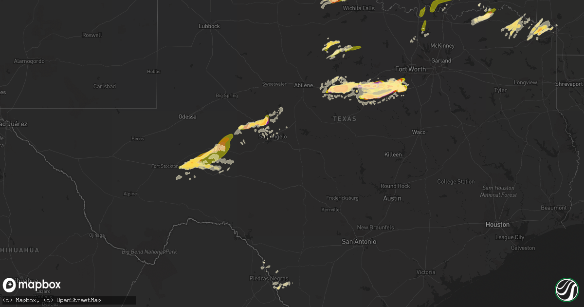
Hail Map in Texas on May 9, 2015
Get this storm
May 9 map
$229
one time, instant access
Download today. No call, no setup
Keep the $229
Bought the map and want the full workflow? Apply the entire $229 to a subscription within 7 days. None of it is wasted.
Every map, not just this one
This buys you this map. Subscription and you get every map we run, in the markets you choose from a few cities to whole states to nationwide. Plus real-time alerts the moment a storm fires.
Contact data
Name, contact info, occupancy, even credit band for addresses in the footprint. You go from where it hit to who to call.
Become the source they trust
Unlimited branding weather history reports on demand. You already have the documented answer ready for the property owner, and you are the one who showed up with it.
Property data and RoofTrace estimates
Pull up any address you have got, its value and the exact code rules for that jurisdiction, straight from One Click Code. Then RoofTrace estimates the squares, pitch, and roof value, priced the way you price.
Storm reports in Texas
Texas
| Date | Description |
|---|---|
| 05/09/20156:59 PM CDT | Trained spotter reported tornado 12 miles nw of stephenville |
| 05/09/20156:22 PM CDT | Trees down near talco on hwy 71 |
| 05/09/20156:20 PM CDT | A local report indicates 1.50 inch wind near 8 ENE NEW BOSTON |
| 05/09/20156:15 PM CDT | A local report indicates 1.75 inch wind near ANNONA |
| 05/09/20156:00 PM CDT | Touchdown at the intersection of muller road and fairview road |
| 05/09/20156:00 PM CDT | A local report indicates 1.75 inch wind near NEW BOSTON |
| 05/09/20155:57 PM CDT | Updated. Touchdown reported to be at the intersection of muller road and fairview road about 4 miles west-northwest of burkburnett. Tornado moved to about 3 miles north |
| 05/09/20155:35 PM CDT | Highway 1540 and highway 98 33.45 and -94.47 |
| 05/09/20155:33 PM CDT | 1540 highway 98 between sims and new boston 33.45 and -94.47 |
| 05/09/20155:33 PM CDT | 1540 highway 98 between sims and new boston |
| 05/09/20155:20 PM CDT | Off of highway 287 |
| 05/09/20155:14 PM CDT | A local report indicates 1.00 inch wind near 1 E WOODSON |
| 05/09/20155:04 PM CDT | 3.25 inch diameter hail reported in eastland. |
| 05/09/20154:55 PM CDT | Large tornado just west of mangum |
| 05/09/20154:39 PM CDT | A local report indicates 60 MPH wind near 4 ESE WOODSON |
| 05/09/20154:34 PM CDT | A local report indicates 1.00 inch wind near 1 N WOODSON |
| 05/09/20154:33 PM CDT | Several spotters have sent photo confirming a tornado south-southwest of cisco. |
| 05/09/20154:32 PM CDT | Nickel to quarters with some half dollars mixed in |
| 05/09/20154:31 PM CDT | Ping pong sized hail in cisco. |
| 05/09/20154:24 PM CDT | Orange-sized hal just south of cisco. |
| 05/09/20154:10 PM CDT | A local report indicates 1.75 inch wind near 3 SE PUTNAM |
| 05/09/20153:35 PM CDT | A local report indicates 1.50 inch wind near THROCKMORTON |
| 05/09/20152:20 PM CDT | Delayed report of hail up to the size of golf balls near lamar point near pat mayse lake |
| 05/09/20159:58 AM CDT | Coop observer reported dime to quarter size hail. |
| 05/09/20156:35 AM CDT | Also noted a funnel cloud near the kimball/dove road area moving rapidly ne |
| 05/09/20154:15 AM CDT | Numerous tree limbs down....which were up to 8 feet in length. |
| 05/09/20153:22 AM CDT | Winds estimated at 70 mph on highway 67 between valera and talpa. |
| 05/09/20153:07 AM CDT | A local report indicates 69 MPH wind near 4 WNW STACY |
| 05/09/20152:27 AM CDT | Numerous tree limbs down throughout the city. The largest limbs were up to 15 feet in length. |
| 05/09/20152:10 AM CDT | A local report indicates 60 MPH wind near 4 N KNICKERBOCKER |
| 05/09/20151:20 AM CDT | A local report indicates 1.00 inch wind near IRAAN |
| 05/09/20151:10 AM CDT | Awning blown down at gas station and tree snapped about 3 feet from the bottom. |
| 05/09/20151:04 AM CDT | Power pole & numerous limbs down at w henderson at high school football stadium. Canopy down at w henderson & ridgeway |
| 05/09/201512:41 AM CDT | Hail up to the size of quarters was reported on us 87 in extreme southwest coke county. |
| 05/09/201512:28 AM CDT | Awning blown down at gas station and tree snapped about 3 feet from the bottom. |
| 05/09/201512:26 AM CDT | A local report indicates 1.75 inch wind near 2 E WATER VALLEY |
| 05/09/201512:00 AM CDT | A local report indicates 1.75 inch wind near BAKERSFIELD |
| 05/08/201511:57 PM CDT | A local report indicates 1.00 inch wind near 19 SW STERLING CITY |
| 05/08/201511:46 PM CDT | Golfball sized hail reported in pecan plantation. |
| 05/08/201511:46 PM CDT | Quarter to golf ball sized hail in pecan plantation |
| 05/08/201511:34 PM CDT | Golf ball sized hail 2 miles south of granbury |
| 05/08/201511:11 PM CDT | A local report indicates 1.75 inch wind near 2 S TOLAR |
| 05/08/201510:19 PM CDT | Measured wind gust by kdto asos. Strong winds from anvil precipitation not reaching the ground. |
| 05/08/20159:45 PM CDT | The border patrol reported quarter size hail. |
| 05/08/20159:24 PM CDT | 2 inch hail in stephenville |
| 05/08/20159:23 PM CDT | Ping pong ball size hail in stephenville |
| 05/08/20159:18 PM CDT | Tennis ball hail reported in stephenville |
| 05/08/20159:02 PM CDT | A local report indicates 1.00 inch wind near 1 S NORMANDY |
| 05/08/20158:10 PM CDT | Trees down on 31st street. |
| 05/08/20157:53 PM CDT | A local report indicates 1.00 inch wind near EL INDIO |
| 05/08/20157:40 PM CDT | Power lines down on county road 4005. |
Cities Impacted by Hail Map on May 9, 2015
- Avondale, CO
- Pueblo, CO
- Mingus, TX
- Gordon, TX
- Stephenville, TX
- Clarksville, TX
- Annona, TX
- Walters, OK
- Granbury, TX
- Bluff Dale, TX
- De Kalb, TX
- New Boston, TX
- Foreman, AR
- Marlow, OK
- Simms, TX
- Carlsbad, TX
- Robert Lee, TX
- Sterling City, TX
- Carbon, TX
- Eastland, TX
- Cisco, TX
- Ranger, TX
- Roosevelt, OK
- Iraan, TX
- Hico, TX
- Joshua, TX
- Cleburne, TX
- Eads, CO
- Desdemona, TX
- De Leon, TX
- Hugo, OK
- Boswell, OK
- Glen Rose, TX
- Duncan, OK
- Burlington, CO
- Arapahoe, CO
- Bogata, TX
- Dublin, TX
- Hooks, TX
- Kearney, NE
- Lipan, TX
- Stonewall, OK
- Ada, OK
- El Indio, TX
- Eagle Pass, TX
- Comanche, OK
- Randlett, OK
- Oklaunion, TX
- Devol, OK
- Electra, TX
- Temple, OK
- Vernon, TX
- Harrold, TX
- Lawton, OK
- Grandfield, OK
- Rush Springs, OK
- Tupelo, OK
- Ozona, TX
- Fort Stockton, TX
- Big Lake, TX
- Midkiff, TX
- Atoka, OK
- Colorado Springs, CO
- Avery, TX
- Bokchito, OK
- Caddo, OK
- Stratford, OK
- Bird City, KS
- Edson, KS
- Brewster, KS
- Woodson, TX
- Carrizo Springs, TX
- Ordway, CO
- Sidney, NE
- Meade, KS
- Throckmorton, TX
- Silverton, TX
- Pratt, KS
- McDonald, KS
- Colby, KS
- Levant, KS
- Roff, OK
- Fitzhugh, OK
- Ogden, AR
- Olney Springs, CO
- Quemado, TX
- Mullinville, KS
- Minneola, KS
- Rocky Ford, CO
- La Junta, CO
- Talco, TX
- Oxford, NE
- Tolar, TX
- Byars, OK
- Valley View, TX
- Collinsville, TX
- Kit Carson, CO
- Cheyenne Wells, CO
- San Angelo, TX
- Mertzon, TX
- Sanger, TX
- Denton, TX
- Allen, OK
- Sugar City, CO
- Ford, KS
- Bucklin, KS
- Breckenridge, TX
- Elmore City, OK
- Foster, OK
- Cement, OK
- Bronte, TX
- Boone, CO
- Forgan, OK
- Newcastle, TX
- Pilot Point, TX
- Tioga, TX
- Waurika, OK
- Ryan, OK
- Krum, TX
- Weatherford, TX
- Overton, NE
- Haworth, OK
- Minden, NE
- Sumner, TX
- Paris, TX
- Brookston, TX
- Powderly, TX
- Cyril, OK
- Godley, TX
- Tipton, OK
- Idabel, OK
- Turon, KS
- Honey Grove, TX
- Miles, TX
- Goodland, KS
- Loomis, NE
- Holdrege, NE
- Wynnewood, OK
- Pauls Valley, OK
- Rising Star, TX
- Shamrock, TX
- Moran, TX
- Stratton, CO
- Alma, AR
- Stringtown, OK
- Yoder, CO
- Cresson, TX
- Texarkana, TX
- Ashdown, AR
- Lindsay, OK
- Lockney, TX
- Quitaque, TX
- Turkey, TX
- Childress, TX
- Mount Pleasant, TX
- Ingalls, KS
- Hastings, OK
- Cross Plains, TX
- Fletcher, OK
- Saint Francis, KS
- Copeland, KS
- Caney, OK
- Selden, KS
- Mead, OK
- Calera, OK
- Sulphur, OK
- Van Buren, AR
- Rudy, AR
- Arthur City, TX
- Montezuma, KS
- Fittstown, OK
- Graham, TX
- Walnut Springs, TX
- Headrick, OK
- Mountain Park, OK
- Blair, OK
- Sublette, KS
- Maysville, OK
- Davidson, OK
- Hobart, OK
- Sweetwater, OK
- Sumner, NE
- Gorman, TX
- Baird, TX
- Peyton, CO
- Lane, OK
- Nemo, TX
- Rainbow, TX
- Iowa Park, TX
- Happy, TX
- Cartwright, OK
- Lone Wolf, OK
- Wingate, TX
- Parks, NE
- Santo, TX
- Wanette, OK
- Petty, TX
- Albany, TX
- Del Norte, CO
- Crowley, TX
- Windom, TX
- Calhan, CO
- Usaf Academy, CO
- Karval, CO
- Hugo, CO
- Ramah, CO
- Bethune, CO
- Swink, CO
- Arlington, CO
- Crowley, CO
- Grant, OK
- Thackerville, OK
- Gainesville, TX
- Marietta, OK
- Whitesboro, TX
- Fort Worth, TX
- Kingston, OK
- Madill, OK
- Gordonville, TX
- Durant, OK
- Sadler, TX
- Indiahoma, OK
- Mountain View, OK
- Altus, OK
- Burkburnett, TX
- Fowler, KS
- Englewood, KS
- Jetmore, KS
- Cimarron, KS
- Plains, KS
- Atwood, KS
- Atlanta, NE
- Orleans, NE
- Funk, NE
- Elm Creek, NE
- Alma, NE
- Bertrand, NE
- Riverdale, NE
- Pleasanton, NE


