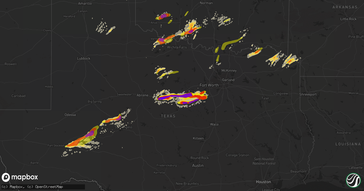
Hail Map on May 9, 2015
Get this storm
May 9 map
$229
one time, instant access
Download today. No call, no setup
Keep the $229
Bought the map and want the full workflow? Apply the entire $229 to a subscription within 7 days. None of it is wasted.
Every map, not just this one
This buys you this map. Subscription and you get every map we run, in the markets you choose from a few cities to whole states to nationwide. Plus real-time alerts the moment a storm fires.
Contact data
Name, contact info, occupancy, even credit band for addresses in the footprint. You go from where it hit to who to call.
Become the source they trust
Unlimited branding weather history reports on demand. You already have the documented answer ready for the property owner, and you are the one who showed up with it.
Property data and RoofTrace estimates
Pull up any address you have got, its value and the exact code rules for that jurisdiction, straight from One Click Code. Then RoofTrace estimates the squares, pitch, and roof value, priced the way you price.
Storm reports
Oklahoma
| Date | Description |
|---|---|
| 05/09/20156:59 PM CDT | Via media |
| 05/09/20156:40 PM CDT | Public reported tornado in kingston... Photo on facebook... Time estimated by radar. |
| 05/09/20156:24 PM CDT | Updated. The tornado /or perhaps a series of two tornadoes/ moved from about 2 miles north of willis at 624 pm to about 5 miles north of willis at about 630 pm. The tor |
| 05/09/20156:17 PM CDT | Tornado reported near the i-44 and highway 70 intersection just west of randlett. |
| 05/09/20156:09 PM CDT | Spotter reported a stovepipe crossing the road less than half a mile in front of him. |
| 05/09/20156:09 PM CDT | Updated. Spotter reported a stovepipe-shaped tornado crossing the road less than half a mile in front of him. Damage reported along us-70 about 5 miles west of randlett |
| 05/09/20155:50 PM CDT | Spotters reported a brief touchdown. |
| 05/09/20155:30 PM CDT | Minor tree damage... A few trees blown down... |
| 05/09/20155:25 PM CDT | 2 large trees down |
| 05/09/20155:00 PM CDT | Volunteer fire department reports several large trees down... Power lines down... Barn roof removed. |
| 05/09/20151:55 PM CDT | A local report indicates 1.00 inch wind near 3 WSW COX CITY |
| 05/09/20151:31 PM CDT | A local report indicates 1.00 inch wind near 6 WNW LOCO |
| 05/09/20151:20 PM CDT | Hail from quarters to half dollars |
| 05/09/20151:05 PM CDT | A local report indicates 1.00 inch wind near 4 NNW MOUNTAIN PARK |
| 05/09/201512:45 PM CDT | Nickel to quarter size hail reported. |
| 05/09/201512:31 PM CDT | A local report indicates 1.00 inch wind near 6 WNW LOCO |
| 05/09/201512:24 PM CDT | A local report indicates 1.00 inch wind near 6 N INDIAHOMA |
| 05/09/201512:00 PM CDT | A local report indicates 1.00 inch wind near 2 W WALTERS |
| 05/09/201512:25 AM CDT | Roof damaged by wind. People evacuated from nursing home. |
| 05/08/201510:22 PM CDT | A local report indicates 1.00 inch wind near 6 SSE ADA |
| 05/08/20158:29 PM CDT | Brief touchdown. |
| 05/08/20158:25 PM CDT | Several barns and other outbuildings damaged or destroyed. Trees and large tree limbs downed. |
| 05/08/20158:25 PM CDT | Updated time. Brief touchdown. |
| 05/08/20158:10 PM CDT | A local report indicates 1.75 inch wind near 6 SE DUNCAN |
| 05/08/20158:10 PM CDT | A local report indicates 1.00 inch wind near 7 SW LANE |
| 05/08/20157:50 PM CDT | A local report indicates 1.00 inch wind near 7 SSW HOLLISTER |
| 05/08/20157:48 PM CDT | A local report indicates 2.75 inch wind near COMANCHE |
| 05/08/20157:42 PM CDT | A local report indicates 1.25 inch wind near 1 S DUNCAN |
| 05/08/20157:41 PM CDT | A local report indicates 1.00 inch wind near COMANCHE |
| 05/08/20157:35 PM CDT | Delayed report from comanche fd |
| 05/08/20157:35 PM CDT | Wall damage to mobile home... Several trees down... One up rooted... Roof decking removed from house. |
| 05/08/20157:34 PM CDT | Highway 81 and highway 7 bypass. |
| 05/08/20157:25 PM CDT | A local report indicates 1.50 inch wind near 3 S CORUM |
| 05/08/20157:25 PM CDT | Updated. Spotters and chasers indicate this tornado developed about 1 mile south-southwest of silo around 725 pm and moved at least to 5 miles north-northwest of durant |
| 05/08/20157:24 PM CDT | A local report indicates 1.50 inch wind near NNW CORUM |
| 05/08/20157:14 PM CDT | A local report indicates 1.00 inch wind near 4 NE FLORIS |
| 05/08/20157:03 PM CDT | A local report indicates 1.25 inch wind near 1 NNE TEMPLE |
Illinois
| Date | Description |
|---|---|
| 05/09/20156:36 PM CDT | Brief touchdown |
| 05/08/20159:15 PM CDT | A swath of wind damage extended from west to east across sumner. Numerous trees...power lines...and power poles were down in an area about 3 blocks wide and 10 blocks l |
Colorado
| Date | Description |
|---|---|
| 05/09/20156:35 PM CDT | Tornado on the ground intermittently. |
| 05/09/20156:26 PM CDT | A local report indicates 2.00 inch wind near 2 E FIRSTVIEW |
| 05/09/20156:24 PM CDT | Tornado back on the ground. Brief tornado lifted and another tornado touched down immediately afterwards. |
| 05/09/20156:20 PM CDT | Tornado on the ground. |
| 05/09/20156:20 PM CDT | Tornado on the ground. |
| 05/09/20156:10 PM CDT | Tornado picked up and touched back down. |
| 05/09/20156:01 PM CDT | Spotter confirmed tornado on the ground. |
| 05/09/20155:40 PM CDT | A local report indicates a tornado near 9 WSW LIMON |
| 05/09/20155:30 PM CDT | A local report indicates a tornado near 10 SE SIMLA |
| 05/09/20155:27 PM CDT | A local report indicates a tornado near 6 SE EADS |
| 05/09/20155:25 PM CDT | Mostly quarter ... Some half dollar sized hail. |
| 05/09/20155:20 PM CDT | A local report indicates a tornado near 15 SE KARVAL |
| 05/09/20155:15 PM CDT | Minor damage to trees and a shed. |
| 05/09/20155:15 PM CDT | A local report indicates a tornado near 8 S KARVAL |
| 05/09/20155:15 PM CDT | Minor damage to trees and a shed. This report was initially reported as a tornado and has been changed to thunderstorm wind damage after a survey was done by the lincol |
| 05/09/20154:56 PM CDT | A local report indicates 1.25 inch wind near 6 S ELLICOTT |
| 05/09/20154:48 PM CDT | A local report indicates 1.00 inch wind near 8 SE SCHRIEVER AFB |
| 05/09/20154:41 PM CDT | Tornado confirmed on the ground. |
| 05/09/20154:41 PM CDT | A local report indicates 1.00 inch wind near 14 SSE SCHRIEVER AFB |
| 05/09/20154:40 PM CDT | Corrected time and location of previous report which was 15 se of karval at 420 pm. |
| 05/09/20154:36 PM CDT | A local report indicates 1.00 inch wind near SWINK |
| 05/09/20154:01 PM CDT | Spotter confirmed tornado on the ground. |
| 05/09/20153:40 PM CDT | A local report indicates 2.50 inch wind near 3 NE BLENDE |
| 05/09/20153:38 PM CDT | A local report indicates 1.75 inch wind near 3 NNE BLENDE |
| 05/09/20153:10 PM CDT | A local report indicates 1.50 inch wind near 3 NNE BLENDE |
| 05/09/20153:07 PM CDT | A local report indicates 1.00 inch wind near 4 S AIR FORCE ACADEMY |
| 05/09/20153:04 PM CDT | A local report indicates 1.00 inch wind near 3 NNE BLENDE |
| 05/09/20152:42 PM CDT | Quarter to half dollar sized. |
| 05/08/20157:52 PM CDT | Storm spotter report of 1.25 inch hail covering the road. |
| 05/08/20157:30 PM CDT | A local report indicates 1.00 inch wind near 10 S BURLINGTON |
| 05/08/20157:14 PM CDT | Spotter report of nickel to quarter sized hail. |
Nebraska
| Date | Description |
|---|---|
| 05/08/201511:50 PM CDT | Mostly nickel size hail with just a couple quarters. |
| 05/08/201511:26 PM CDT | Storm spotter reports an intermittent tornado on the ground 6 miles ssw of mccook... Ne. |
| 05/08/20159:10 PM CDT | A local report indicates 1.00 inch wind near 6 NE HOLDREGE |
| 05/08/20159:10 PM CDT | A local report indicates 1.00 inch wind near 6 NW HOLDREGE |
| 05/08/20158:36 PM CDT | Spotter confirmed brief tornado touchdown |
| 05/08/20158:25 PM CDT | Brief tornado lasted less than 2 min with 1/4 mile track or less. Crossed highway 89. |
Arkansas
| Date | Description |
|---|---|
| 05/09/20154:05 PM CDT | Trees were blown down across hwy 27 north of murfreesboro. |
| 05/09/20154:00 PM CDT | Power lines down on mt.pleasant dr. |
| 05/09/20152:35 AM CDT | Scattered trees with broken limbs in southern half of county. Some small trees blown down. |
| 05/09/20152:05 AM CDT | Several trees blown down. Many broken limbs. A stop sign was turned around by the wind. |
| 05/09/20151:54 AM CDT | Powerlines down in fort smith. |
| 05/08/20157:39 PM CDT | Trees were uprooted and a power pole was snapped at the intersection of hwy 73 and hwy 195 nw of hope. |
Kansas
| Date | Description |
|---|---|
| 05/09/20152:10 PM CDT | Emergency manager reports pivots destroyed approximately 2 miles south of campus in nw gove county. Time is radar estimated. |
| 05/09/201511:48 AM CDT | A local report indicates 59 MPH wind near GARDEN CITY |
| 05/09/201511:35 AM CDT | A local report indicates 1.00 inch wind near 8 E PRATT |
| 05/08/201511:07 PM CDT | Trained spotter reports a tornado on the ground near traer. |
| 05/08/201511:02 PM CDT | Storm chaser reports power poles snapped along county rd 314 1 mile north of 346. |
| 05/08/201510:44 PM CDT | Tornado still on the ground sw of oberlin. |
| 05/08/201510:24 PM CDT | Tornado on the ground 7 miles nnw of selden. |
| 05/08/201510:22 PM CDT | A local report indicates 70 MPH wind near 2 E MACKSVILLE |
| 05/08/201510:20 PM CDT | Report of 1.25 inch hail. |
| 05/08/201510:17 PM CDT | Tornado on the ground nnw of selden. |
| 05/08/20159:55 PM CDT | Trained spotter reports a large... Multi-vortex tornado ese of rexford. |
| 05/08/20159:50 PM CDT | Trained spotter reports a tornado on the ground ne of menlo. |
| 05/08/20159:33 PM CDT | Trained spotter reports a large tornado on the ground with an intermittent small tornado as well. |
| 05/08/20159:23 PM CDT | Spotter reports a large wedge tornado on the ground 1 mile north of angelus. |
| 05/08/20159:12 PM CDT | Storm chaser reports a tornado on the ground northeast of oakley. |
| 05/08/20159:05 PM CDT | Law enforcement reports of road signs damaged 1 mile west of bird city. Time is radar estimated. |
| 05/08/20159:01 PM CDT | Trained spotter reports a tornado on the ground 1 mile northwest of grinnell. |
| 05/08/20158:54 PM CDT | A local report indicates 1.00 inch wind near BUCKLIN |
| 05/08/20158:51 PM CDT | Trained spotter reports a tornado on the ground 1 mile south of grinnell. |
| 05/08/20158:48 PM CDT | Emergency manager reports pivots destroyed approximately 2 miles south of campus in nw gove county. Time is radar estimated. |
| 05/08/20158:45 PM CDT | Trained spotter reports a tornado on the ground 3 miles east of oakley. |
| 05/08/20158:38 PM CDT | Trained spotter reports a tornado on the ground 1 mile south of grinnell. |
| 05/08/20158:38 PM CDT | Tornado on the ground south of i-70 near grinnell. |
| 05/08/20158:38 PM CDT | Caller reports a tornado on the ground north of county road s. |
| 05/08/20158:37 PM CDT | A local report indicates 1.00 inch wind near 1 N KINGSDOWN |
| 05/08/20158:16 PM CDT | Emergency manager reports a tornado on the ground intermittently. |
| 05/08/20158:12 PM CDT | Tornado on the ground. Live on kwch. |
| 05/08/20158:08 PM CDT | Caller reports a small tornado on the ground. |
| 05/08/20158:00 PM CDT | Spotter reports a large tornado on the ground. |
| 05/08/20157:58 PM CDT | Tornado on the ground. Reported by kwch. Also reported by local dispatch and spotters. |
| 05/08/20157:55 PM CDT | Spotter reports a tornado on the ground. |
| 05/08/20157:35 PM CDT | A local report indicates a tornado near 4 N COLLYER |
| 05/08/20157:32 PM CDT | Law enforcement reports a tornado north of interstate 70 mile marker 108. |
| 05/08/20157:28 PM CDT | A local report indicates a tornado near 2 N COLLYER |
| 05/08/20157:19 PM CDT | A local report indicates 1.00 inch wind near COPELAND |
Texas
| Date | Description |
|---|---|
| 05/09/20156:59 PM CDT | Trained spotter reported tornado 12 miles nw of stephenville |
| 05/09/20156:22 PM CDT | Trees down near talco on hwy 71 |
| 05/09/20156:20 PM CDT | A local report indicates 1.50 inch wind near 8 ENE NEW BOSTON |
| 05/09/20156:15 PM CDT | A local report indicates 1.75 inch wind near ANNONA |
| 05/09/20156:00 PM CDT | Touchdown at the intersection of muller road and fairview road |
| 05/09/20156:00 PM CDT | A local report indicates 1.75 inch wind near NEW BOSTON |
| 05/09/20155:57 PM CDT | Updated. Touchdown reported to be at the intersection of muller road and fairview road about 4 miles west-northwest of burkburnett. Tornado moved to about 3 miles north |
| 05/09/20155:35 PM CDT | Highway 1540 and highway 98 33.45 and -94.47 |
| 05/09/20155:33 PM CDT | 1540 highway 98 between sims and new boston 33.45 and -94.47 |
| 05/09/20155:33 PM CDT | 1540 highway 98 between sims and new boston |
| 05/09/20155:20 PM CDT | Off of highway 287 |
| 05/09/20155:14 PM CDT | A local report indicates 1.00 inch wind near 1 E WOODSON |
| 05/09/20155:04 PM CDT | 3.25 inch diameter hail reported in eastland. |
| 05/09/20154:55 PM CDT | Large tornado just west of mangum |
| 05/09/20154:39 PM CDT | A local report indicates 60 MPH wind near 4 ESE WOODSON |
| 05/09/20154:34 PM CDT | A local report indicates 1.00 inch wind near 1 N WOODSON |
| 05/09/20154:33 PM CDT | Several spotters have sent photo confirming a tornado south-southwest of cisco. |
| 05/09/20154:32 PM CDT | Nickel to quarters with some half dollars mixed in |
| 05/09/20154:31 PM CDT | Ping pong sized hail in cisco. |
| 05/09/20154:24 PM CDT | Orange-sized hal just south of cisco. |
| 05/09/20154:10 PM CDT | A local report indicates 1.75 inch wind near 3 SE PUTNAM |
| 05/09/20153:35 PM CDT | A local report indicates 1.50 inch wind near THROCKMORTON |
| 05/09/20152:20 PM CDT | Delayed report of hail up to the size of golf balls near lamar point near pat mayse lake |
| 05/09/20159:58 AM CDT | Coop observer reported dime to quarter size hail. |
| 05/09/20156:35 AM CDT | Also noted a funnel cloud near the kimball/dove road area moving rapidly ne |
| 05/09/20154:15 AM CDT | Numerous tree limbs down....which were up to 8 feet in length. |
| 05/09/20153:22 AM CDT | Winds estimated at 70 mph on highway 67 between valera and talpa. |
| 05/09/20153:07 AM CDT | A local report indicates 69 MPH wind near 4 WNW STACY |
| 05/09/20152:27 AM CDT | Numerous tree limbs down throughout the city. The largest limbs were up to 15 feet in length. |
| 05/09/20152:10 AM CDT | A local report indicates 60 MPH wind near 4 N KNICKERBOCKER |
| 05/09/20151:20 AM CDT | A local report indicates 1.00 inch wind near IRAAN |
| 05/09/20151:10 AM CDT | Awning blown down at gas station and tree snapped about 3 feet from the bottom. |
| 05/09/20151:04 AM CDT | Power pole & numerous limbs down at w henderson at high school football stadium. Canopy down at w henderson & ridgeway |
| 05/09/201512:41 AM CDT | Hail up to the size of quarters was reported on us 87 in extreme southwest coke county. |
| 05/09/201512:28 AM CDT | Awning blown down at gas station and tree snapped about 3 feet from the bottom. |
| 05/09/201512:26 AM CDT | A local report indicates 1.75 inch wind near 2 E WATER VALLEY |
| 05/09/201512:00 AM CDT | A local report indicates 1.75 inch wind near BAKERSFIELD |
| 05/08/201511:57 PM CDT | A local report indicates 1.00 inch wind near 19 SW STERLING CITY |
| 05/08/201511:46 PM CDT | Golfball sized hail reported in pecan plantation. |
| 05/08/201511:46 PM CDT | Quarter to golf ball sized hail in pecan plantation |
| 05/08/201511:34 PM CDT | Golf ball sized hail 2 miles south of granbury |
| 05/08/201511:11 PM CDT | A local report indicates 1.75 inch wind near 2 S TOLAR |
| 05/08/201510:19 PM CDT | Measured wind gust by kdto asos. Strong winds from anvil precipitation not reaching the ground. |
| 05/08/20159:45 PM CDT | The border patrol reported quarter size hail. |
| 05/08/20159:24 PM CDT | 2 inch hail in stephenville |
| 05/08/20159:23 PM CDT | Ping pong ball size hail in stephenville |
| 05/08/20159:18 PM CDT | Tennis ball hail reported in stephenville |
| 05/08/20159:02 PM CDT | A local report indicates 1.00 inch wind near 1 S NORMANDY |
| 05/08/20158:10 PM CDT | Trees down on 31st street. |
| 05/08/20157:53 PM CDT | A local report indicates 1.00 inch wind near EL INDIO |
| 05/08/20157:40 PM CDT | Power lines down on county road 4005. |
Cities Impacted by Hail Map on May 9, 2015
- Avondale, CO
- Pueblo, CO
- Mingus, TX
- Gordon, TX
- Stephenville, TX
- Clarksville, TX
- Annona, TX
- Walters, OK
- Granbury, TX
- Bluff Dale, TX
- De Kalb, TX
- New Boston, TX
- Foreman, AR
- Marlow, OK
- Simms, TX
- Carlsbad, TX
- Robert Lee, TX
- Sterling City, TX
- Carbon, TX
- Eastland, TX
- Cisco, TX
- Ranger, TX
- Roosevelt, OK
- Iraan, TX
- Hico, TX
- Joshua, TX
- Cleburne, TX
- Eads, CO
- Desdemona, TX
- De Leon, TX
- Hugo, OK
- Boswell, OK
- Glen Rose, TX
- Duncan, OK
- Burlington, CO
- Arapahoe, CO
- Bogata, TX
- Dublin, TX
- Hooks, TX
- Kearney, NE
- Lipan, TX
- Stonewall, OK
- Ada, OK
- El Indio, TX
- Eagle Pass, TX
- Comanche, OK
- Randlett, OK
- Oklaunion, TX
- Devol, OK
- Electra, TX
- Temple, OK
- Vernon, TX
- Harrold, TX
- Lawton, OK
- Grandfield, OK
- Rush Springs, OK
- Tupelo, OK
- Ozona, TX
- Fort Stockton, TX
- Big Lake, TX
- Midkiff, TX
- Atoka, OK
- Colorado Springs, CO
- Avery, TX
- Bokchito, OK
- Caddo, OK
- Stratford, OK
- Bird City, KS
- Edson, KS
- Brewster, KS
- Woodson, TX
- Carrizo Springs, TX
- Ordway, CO
- Sidney, NE
- Meade, KS
- Throckmorton, TX
- Silverton, TX
- Pratt, KS
- McDonald, KS
- Colby, KS
- Levant, KS
- Roff, OK
- Fitzhugh, OK
- Ogden, AR
- Olney Springs, CO
- Quemado, TX
- Mullinville, KS
- Minneola, KS
- Rocky Ford, CO
- La Junta, CO
- Talco, TX
- Oxford, NE
- Tolar, TX
- Byars, OK
- Valley View, TX
- Collinsville, TX
- Kit Carson, CO
- Cheyenne Wells, CO
- San Angelo, TX
- Mertzon, TX
- Sanger, TX
- Denton, TX
- Allen, OK
- Sugar City, CO
- Ford, KS
- Bucklin, KS
- Breckenridge, TX
- Elmore City, OK
- Foster, OK
- Cement, OK
- Bronte, TX
- Boone, CO
- Forgan, OK
- Newcastle, TX
- Pilot Point, TX
- Tioga, TX
- Waurika, OK
- Ryan, OK
- Krum, TX
- Weatherford, TX
- Overton, NE
- Haworth, OK
- Minden, NE
- Sumner, TX
- Paris, TX
- Brookston, TX
- Powderly, TX
- Cyril, OK
- Godley, TX
- Tipton, OK
- Idabel, OK
- Turon, KS
- Honey Grove, TX
- Miles, TX
- Goodland, KS
- Loomis, NE
- Holdrege, NE
- Wynnewood, OK
- Pauls Valley, OK
- Rising Star, TX
- Shamrock, TX
- Moran, TX
- Stratton, CO
- Alma, AR
- Stringtown, OK
- Yoder, CO
- Cresson, TX
- Texarkana, TX
- Ashdown, AR
- Lindsay, OK
- Lockney, TX
- Quitaque, TX
- Turkey, TX
- Childress, TX
- Mount Pleasant, TX
- Ingalls, KS
- Hastings, OK
- Cross Plains, TX
- Fletcher, OK
- Saint Francis, KS
- Copeland, KS
- Caney, OK
- Selden, KS
- Mead, OK
- Calera, OK
- Sulphur, OK
- Van Buren, AR
- Rudy, AR
- Arthur City, TX
- Montezuma, KS
- Fittstown, OK
- Graham, TX
- Walnut Springs, TX
- Headrick, OK
- Mountain Park, OK
- Blair, OK
- Sublette, KS
- Maysville, OK
- Davidson, OK
- Hobart, OK
- Sweetwater, OK
- Sumner, NE
- Gorman, TX
- Baird, TX
- Peyton, CO
- Lane, OK
- Nemo, TX
- Rainbow, TX
- Iowa Park, TX
- Happy, TX
- Cartwright, OK
- Lone Wolf, OK
- Wingate, TX
- Parks, NE
- Santo, TX
- Wanette, OK
- Petty, TX
- Albany, TX
- Del Norte, CO
- Crowley, TX
- Windom, TX
- Calhan, CO
- Usaf Academy, CO
- Karval, CO
- Hugo, CO
- Ramah, CO
- Bethune, CO
- Swink, CO
- Arlington, CO
- Crowley, CO
- Grant, OK
- Thackerville, OK
- Gainesville, TX
- Marietta, OK
- Whitesboro, TX
- Fort Worth, TX
- Kingston, OK
- Madill, OK
- Gordonville, TX
- Durant, OK
- Sadler, TX
- Indiahoma, OK
- Mountain View, OK
- Altus, OK
- Burkburnett, TX
- Fowler, KS
- Englewood, KS
- Jetmore, KS
- Cimarron, KS
- Plains, KS
- Atwood, KS
- Atlanta, NE
- Orleans, NE
- Funk, NE
- Elm Creek, NE
- Alma, NE
- Bertrand, NE
- Riverdale, NE
- Pleasanton, NE