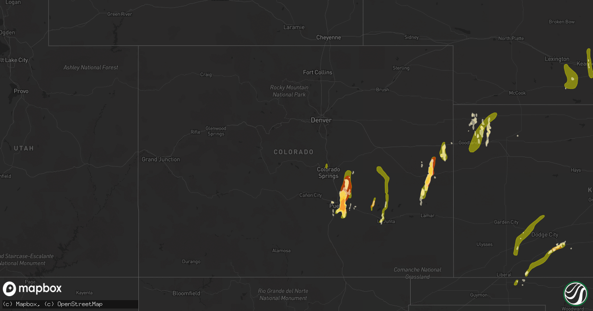
Hail Map in Colorado on May 9, 2015
Get this storm
May 9 map
$229
one time, instant access
Download today. No call, no setup
Keep the $229
Bought the map and want the full workflow? Apply the entire $229 to a subscription within 7 days. None of it is wasted.
Every map, not just this one
This buys you this map. Subscription and you get every map we run, in the markets you choose from a few cities to whole states to nationwide. Plus real-time alerts the moment a storm fires.
Contact data
Name, contact info, occupancy, even credit band for addresses in the footprint. You go from where it hit to who to call.
Become the source they trust
Unlimited branding weather history reports on demand. You already have the documented answer ready for the property owner, and you are the one who showed up with it.
Property data and RoofTrace estimates
Pull up any address you have got, its value and the exact code rules for that jurisdiction, straight from One Click Code. Then RoofTrace estimates the squares, pitch, and roof value, priced the way you price.
Storm reports in Colorado
Colorado
| Date | Description |
|---|---|
| 05/09/20156:35 PM CDT | Tornado on the ground intermittently. |
| 05/09/20156:26 PM CDT | A local report indicates 2.00 inch wind near 2 E FIRSTVIEW |
| 05/09/20156:24 PM CDT | Tornado back on the ground. Brief tornado lifted and another tornado touched down immediately afterwards. |
| 05/09/20156:20 PM CDT | Tornado on the ground. |
| 05/09/20156:20 PM CDT | Tornado on the ground. |
| 05/09/20156:10 PM CDT | Tornado picked up and touched back down. |
| 05/09/20156:01 PM CDT | Spotter confirmed tornado on the ground. |
| 05/09/20155:40 PM CDT | A local report indicates a tornado near 9 WSW LIMON |
| 05/09/20155:30 PM CDT | A local report indicates a tornado near 10 SE SIMLA |
| 05/09/20155:27 PM CDT | A local report indicates a tornado near 6 SE EADS |
| 05/09/20155:25 PM CDT | Mostly quarter ... Some half dollar sized hail. |
| 05/09/20155:20 PM CDT | A local report indicates a tornado near 15 SE KARVAL |
| 05/09/20155:15 PM CDT | A local report indicates a tornado near 8 S KARVAL |
| 05/09/20155:15 PM CDT | Minor damage to trees and a shed. This report was initially reported as a tornado and has been changed to thunderstorm wind damage after a survey was done by the lincol |
| 05/09/20155:15 PM CDT | Minor damage to trees and a shed. |
| 05/09/20154:56 PM CDT | A local report indicates 1.25 inch wind near 6 S ELLICOTT |
| 05/09/20154:48 PM CDT | A local report indicates 1.00 inch wind near 8 SE SCHRIEVER AFB |
| 05/09/20154:41 PM CDT | A local report indicates 1.00 inch wind near 14 SSE SCHRIEVER AFB |
| 05/09/20154:41 PM CDT | Tornado confirmed on the ground. |
| 05/09/20154:40 PM CDT | Corrected time and location of previous report which was 15 se of karval at 420 pm. |
| 05/09/20154:36 PM CDT | A local report indicates 1.00 inch wind near SWINK |
| 05/09/20154:01 PM CDT | Spotter confirmed tornado on the ground. |
| 05/09/20153:40 PM CDT | A local report indicates 2.50 inch wind near 3 NE BLENDE |
| 05/09/20153:38 PM CDT | A local report indicates 1.75 inch wind near 3 NNE BLENDE |
| 05/09/20153:10 PM CDT | A local report indicates 1.50 inch wind near 3 NNE BLENDE |
| 05/09/20153:07 PM CDT | A local report indicates 1.00 inch wind near 4 S AIR FORCE ACADEMY |
| 05/09/20153:04 PM CDT | A local report indicates 1.00 inch wind near 3 NNE BLENDE |
| 05/09/20152:42 PM CDT | Quarter to half dollar sized. |
| 05/08/20157:52 PM CDT | Storm spotter report of 1.25 inch hail covering the road. |
| 05/08/20157:30 PM CDT | A local report indicates 1.00 inch wind near 10 S BURLINGTON |
| 05/08/20157:14 PM CDT | Spotter report of nickel to quarter sized hail. |
Cities Impacted by Hail Map on May 9, 2015
- Avondale, CO
- Pueblo, CO
- Mingus, TX
- Gordon, TX
- Stephenville, TX
- Clarksville, TX
- Annona, TX
- Walters, OK
- Granbury, TX
- Bluff Dale, TX
- De Kalb, TX
- New Boston, TX
- Foreman, AR
- Marlow, OK
- Simms, TX
- Carlsbad, TX
- Robert Lee, TX
- Sterling City, TX
- Carbon, TX
- Eastland, TX
- Cisco, TX
- Ranger, TX
- Roosevelt, OK
- Iraan, TX
- Hico, TX
- Joshua, TX
- Cleburne, TX
- Eads, CO
- Desdemona, TX
- De Leon, TX
- Hugo, OK
- Boswell, OK
- Glen Rose, TX
- Duncan, OK
- Burlington, CO
- Arapahoe, CO
- Bogata, TX
- Dublin, TX
- Hooks, TX
- Kearney, NE
- Lipan, TX
- Stonewall, OK
- Ada, OK
- El Indio, TX
- Eagle Pass, TX
- Comanche, OK
- Randlett, OK
- Oklaunion, TX
- Devol, OK
- Electra, TX
- Temple, OK
- Vernon, TX
- Harrold, TX
- Lawton, OK
- Grandfield, OK
- Rush Springs, OK
- Tupelo, OK
- Ozona, TX
- Fort Stockton, TX
- Big Lake, TX
- Midkiff, TX
- Atoka, OK
- Colorado Springs, CO
- Avery, TX
- Bokchito, OK
- Caddo, OK
- Stratford, OK
- Bird City, KS
- Edson, KS
- Brewster, KS
- Woodson, TX
- Carrizo Springs, TX
- Ordway, CO
- Sidney, NE
- Meade, KS
- Throckmorton, TX
- Silverton, TX
- Pratt, KS
- McDonald, KS
- Colby, KS
- Levant, KS
- Roff, OK
- Fitzhugh, OK
- Ogden, AR
- Olney Springs, CO
- Quemado, TX
- Mullinville, KS
- Minneola, KS
- Rocky Ford, CO
- La Junta, CO
- Talco, TX
- Oxford, NE
- Tolar, TX
- Byars, OK
- Valley View, TX
- Collinsville, TX
- Kit Carson, CO
- Cheyenne Wells, CO
- San Angelo, TX
- Mertzon, TX
- Sanger, TX
- Denton, TX
- Allen, OK
- Sugar City, CO
- Ford, KS
- Bucklin, KS
- Breckenridge, TX
- Elmore City, OK
- Foster, OK
- Cement, OK
- Bronte, TX
- Boone, CO
- Forgan, OK
- Newcastle, TX
- Pilot Point, TX
- Tioga, TX
- Waurika, OK
- Ryan, OK
- Krum, TX
- Weatherford, TX
- Overton, NE
- Haworth, OK
- Minden, NE
- Sumner, TX
- Paris, TX
- Brookston, TX
- Powderly, TX
- Cyril, OK
- Godley, TX
- Tipton, OK
- Idabel, OK
- Turon, KS
- Honey Grove, TX
- Miles, TX
- Goodland, KS
- Loomis, NE
- Holdrege, NE
- Wynnewood, OK
- Pauls Valley, OK
- Rising Star, TX
- Shamrock, TX
- Moran, TX
- Stratton, CO
- Alma, AR
- Stringtown, OK
- Yoder, CO
- Cresson, TX
- Texarkana, TX
- Ashdown, AR
- Lindsay, OK
- Lockney, TX
- Quitaque, TX
- Turkey, TX
- Childress, TX
- Mount Pleasant, TX
- Ingalls, KS
- Hastings, OK
- Cross Plains, TX
- Fletcher, OK
- Saint Francis, KS
- Copeland, KS
- Caney, OK
- Selden, KS
- Mead, OK
- Calera, OK
- Sulphur, OK
- Van Buren, AR
- Rudy, AR
- Arthur City, TX
- Montezuma, KS
- Fittstown, OK
- Graham, TX
- Walnut Springs, TX
- Headrick, OK
- Mountain Park, OK
- Blair, OK
- Sublette, KS
- Maysville, OK
- Davidson, OK
- Hobart, OK
- Sweetwater, OK
- Sumner, NE
- Gorman, TX
- Baird, TX
- Peyton, CO
- Lane, OK
- Nemo, TX
- Rainbow, TX
- Iowa Park, TX
- Happy, TX
- Cartwright, OK
- Lone Wolf, OK
- Wingate, TX
- Parks, NE
- Santo, TX
- Wanette, OK
- Petty, TX
- Albany, TX
- Del Norte, CO
- Crowley, TX
- Windom, TX
- Calhan, CO
- Usaf Academy, CO
- Karval, CO
- Hugo, CO
- Ramah, CO
- Bethune, CO
- Swink, CO
- Arlington, CO
- Crowley, CO
- Grant, OK
- Thackerville, OK
- Gainesville, TX
- Marietta, OK
- Whitesboro, TX
- Fort Worth, TX
- Kingston, OK
- Madill, OK
- Gordonville, TX
- Durant, OK
- Sadler, TX
- Indiahoma, OK
- Mountain View, OK
- Altus, OK
- Burkburnett, TX
- Fowler, KS
- Englewood, KS
- Jetmore, KS
- Cimarron, KS
- Plains, KS
- Atwood, KS
- Atlanta, NE
- Orleans, NE
- Funk, NE
- Elm Creek, NE
- Alma, NE
- Bertrand, NE
- Riverdale, NE
- Pleasanton, NE


