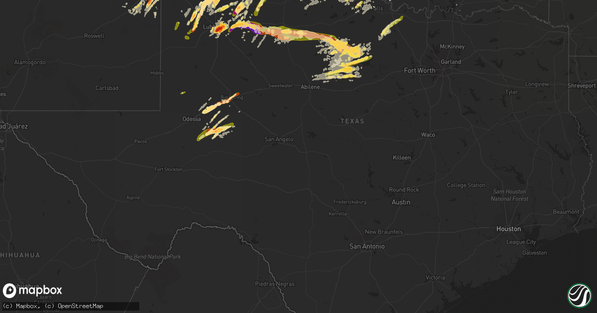
Hail Map in Texas on May 8, 2015
Get this storm
May 8 map
$229
one time, instant access
Download today. No call, no setup
Keep the $229
Bought the map and want the full workflow? Apply the entire $229 to a subscription within 7 days. None of it is wasted.
Every map, not just this one
This buys you this map. Subscription and you get every map we run, in the markets you choose from a few cities to whole states to nationwide. Plus real-time alerts the moment a storm fires.
Contact data
Name, contact info, occupancy, even credit band for addresses in the footprint. You go from where it hit to who to call.
Become the source they trust
Unlimited branding weather history reports on demand. You already have the documented answer ready for the property owner, and you are the one who showed up with it.
Property data and RoofTrace estimates
Pull up any address you have got, its value and the exact code rules for that jurisdiction, straight from One Click Code. Then RoofTrace estimates the squares, pitch, and roof value, priced the way you price.
Storm reports in Texas
Texas
| Date | Description |
|---|---|
| 05/08/20156:40 PM CDT | Tornado on the ground reported by sheriff office . |
| 05/08/20156:22 PM CDT | Public reported tornado on thr ground. |
| 05/08/20155:45 PM CDT | A local report indicates 70 MPH wind near ROCHESTER |
| 05/08/20155:30 PM CDT | Trained spotter report relayed through haskell county sheriff office. Tornado was on the ground. |
| 05/08/20155:30 PM CDT | A local report indicates 60 MPH wind near ROCHESTER |
| 05/08/20155:21 PM CDT | Storm chaser provided photograph. Minor damage to a metal outbuilding also reported. |
| 05/08/20155:20 PM CDT | Spotter reports wind damage to silo and trees between harold and electra... Winds estimated 80 to 90 mph. |
| 05/08/20155:00 PM CDT | Trees blown down onto road |
| 05/08/20154:28 PM CDT | Tornado developed about 4 miles northwest of lockett around 428 pm and moved to near lockett per law enforecement and storm chaser reports around 436 pm. Trees were dam |
| 05/08/20154:23 PM CDT | Spotter was located 6 wnw of vernon reporting brief tornado 4 miles to their west. Multiple brief funnels also reported. Report confirmed by law enforcement. |
| 05/08/20154:22 PM CDT | A local report indicates 66 MPH wind near 9 S CHILLICOTHE |
| 05/08/20153:20 PM CDT | West texas mesonet report |
| 05/08/20153:17 PM CDT | Hail at intersection of hwy 40 and 651 |
| 05/08/20152:38 PM CDT | A local report indicates 2.75 inch wind near RANSOM CANYON |
| 05/08/20152:32 PM CDT | A local report indicates 1.00 inch wind near 4 SSW RANSOM CANYON |
| 05/08/20152:31 PM CDT | A local report indicates 3.00 inch wind near 10 SE LUBBOCK |
| 05/08/20152:31 PM CDT | Softball size hail around posey gin west of slaton. Reports of windows blown out |
| 05/08/20152:29 PM CDT | 2 miles east of 87 on woodrow road |
| 05/08/20152:15 PM CDT | A local report indicates 1.00 inch wind near PETERSBURG |
| 05/08/201512:22 PM CDT | A local report indicates 2.50 inch wind near 5 E CHILDRESS |
| 05/08/201511:46 AM CDT | A local report indicates 1.50 inch wind near NORTHFIELD |
| 05/08/201511:22 AM CDT | A local report indicates 1.00 inch wind near MATADOR |
| 05/08/201510:56 AM CDT | Golf ball size hail near the plainview golf course relayed by plainview daily herald |
| 05/08/201510:44 AM CDT | A local report indicates 1.00 inch wind near FLOYDADA |
| 05/08/201510:41 AM CDT | Ham radio report relayed by nws amarillo |
| 05/08/201510:25 AM CDT | Quarter size hail in south side of hail center at the high school |
| 05/08/201510:14 AM CDT | A local report indicates 1.25 inch wind near COTTON CENTER |
| 05/08/201510:13 AM CDT | A local report indicates 1.75 inch wind near COTTON CENTER |
| 05/08/20159:47 AM CDT | A local report indicates 1.00 inch wind near ANTON |
| 05/08/20159:42 AM CDT | A local report indicates 1.75 inch wind near 2 S WHITHARRAL |
| 05/08/20159:10 AM CDT | A local report indicates 1.00 inch wind near OPDYKE WEST |
| 05/08/20156:35 AM CDT | Radar estimated time at 635am |
| 05/08/20155:40 AM CDT | Nickle to quarter size hail at bishop hills |
| 05/08/20155:40 AM CDT | Golf ball size in tascosa hills along with power being out. |
| 05/08/20155:40 AM CDT | Nickle to quarter size hail at bishop hills |
| 05/08/20155:25 AM CDT | A local report indicates 2.50 inch wind near 2 E BUSHLAND |
| 05/08/20155:00 AM CDT | Radar estimated time around 500am |
| 05/08/20154:45 AM CDT | Time estimated between 445am and 500am |
| 05/07/201511:28 PM CDT | Some of the hailstones were slightly larger than a quarter. |
| 05/07/201511:23 PM CDT | A local report indicates 1.00 inch wind near BIG SPRING |
| 05/07/201511:20 PM CDT | A local report indicates 1.75 inch wind near BRECKENRIDGE |
| 05/07/201510:45 PM CDT | The martin county so reported ping pong ball size hail on interstate 20 at mile marker 161. |
| 05/07/201510:43 PM CDT | A local report indicates 1.00 inch wind near ANDREWS |
| 05/07/201510:23 PM CDT | A local report indicates 1.00 inch wind near ALBANY |
| 05/07/201510:02 PM CDT | Tennis ball size hail reported from 1002 to 1007 pm cdt. |
| 05/07/20159:55 PM CDT | A local report indicates 2.00 inch wind near GREENWOOD |
| 05/07/20159:47 PM CDT | A local report indicates 2.00 inch wind near GREENWOOD |
| 05/07/20159:38 PM CDT | A local report indicates 1.25 inch wind near 1 S MIDLAND |
| 05/07/20159:32 PM CDT | A local report indicates 1.00 inch wind near VALLEY VIEW |
| 05/07/20159:29 PM CDT | A local report indicates 1.25 inch wind near 1 S MIDLAND |
| 05/07/20159:29 PM CDT | A local report indicates 1.75 inch wind near 1 SE MIDLAND |
| 05/07/20159:26 PM CDT | A local report indicates 1.00 inch wind near 1 S MIDLAND |
| 05/07/20159:16 PM CDT | Ping pong size hail on the east side of hubbard creek lake. |
| 05/07/20158:31 PM CDT | A local report indicates 1.75 inch wind near 4 E MIDKIFF |
| 05/07/20158:20 PM CDT | Golf ball size hail reported in midkiff between 820 and 825 pm cdt. |
| 05/07/20158:00 PM CDT | A local report indicates 1.00 inch wind near WOODSON |
| 05/07/20157:59 PM CDT | Glf ball hail 8 w of graham on fm 3109 |
| 05/07/20157:44 PM CDT | 66 mph wind gust measured by the bowie... Tx automated weather observation system |
| 05/07/20157:37 PM CDT | Numerous tree limbs down. |
| 05/07/20157:15 PM CDT | A local report indicates 1.50 inch wind near ELBERT |
| 05/07/20157:06 PM CDT | A local report indicates 1.75 inch wind near 4 SSW THROCKMORTON |
All States Impacted by Hail Map on May 8, 2015
Cities Impacted by Hail Map on May 8, 2015
- Childress, TX
- Crosbyton, TX
- Midland, TX
- Friona, TX
- Gracemont, OK
- Fort Cobb, OK
- Big Lake, TX
- Garden City, TX
- Lubbock, TX
- Dodson, TX
- Petersburg, TX
- Floydada, TX
- Hereford, TX
- Quanah, TX
- Carnegie, OK
- Mountain View, OK
- Cordell, OK
- Okemah, OK
- Harrold, TX
- Grandfield, OK
- Davidson, OK
- Electra, TX
- Devol, OK
- Tucumcari, NM
- Snyder, TX
- Stanton, TX
- Adrian, TX
- Muleshoe, TX
- Quitaque, TX
- Vernon, TX
- Apache, OK
- La Junta, CO
- Macomb, OK
- Tecumseh, OK
- Rogers, NM
- Causey, NM
- Elida, NM
- Mustang, OK
- Breckenridge, TX
- Knox City, TX
- Seymour, TX
- Avondale, CO
- Rye, CO
- Pueblo, CO
- Boone, CO
- Big Spring, TX
- Wewoka, OK
- Abernathy, TX
- Gould, OK
- Mangum, OK
- Portales, NM
- Blair, OK
- Paducah, TX
- Hollis, OK
- Ransom Canyon, TX
- Slaton, TX
- Woodson, TX
- Amarillo, TX
- Blanchard, OK
- Oklahoma City, OK
- Norman, OK
- Newcastle, OK
- Flomot, TX
- Matador, TX
- Panhandle, TX
- Plainview, TX
- Oklaunion, TX
- Wildorado, TX
- Crowell, TX
- Canyon, TX
- Bryson, TX
- Graford, TX
- Tell, TX
- Albany, TX
- Hobart, OK
- Roosevelt, OK
- Lone Wolf, OK
- Chillicothe, TX
- Cisco, TX
- Mcadoo, TX
- Happy, TX
- Gotebo, OK
- Altus, OK
- Burkburnett, TX
- Iowa Park, TX
- Randlett, OK
- Loveland, OK
- Vega, TX
- Newcastle, TX
- Shawnee, OK
- Olustee, OK
- Duke, OK
- Throckmorton, TX
- Graham, TX
- Weleetka, OK
- Newalla, OK
- Mcloud, OK
- Wellington, TX
- Post, TX
- Ralls, TX
- Roaring Springs, TX
- Dimmitt, TX
- Moran, TX
- Abilene, TX
- Kress, TX
- El Reno, OK
- Colbert, OK
- Lorenzo, TX
- Eastland, TX
- Amherst, TX
- Levelland, TX
- Anton, TX
- Headrick, OK
- Claude, TX
- Prague, OK
- Mead, OK
- Calera, OK
- Lockney, TX
- Ranger, TX
- Aspermont, TX
- Munday, TX
- South Bend, TX
- O'Brien, TX
- Caddo, TX
- Dickens, TX
- Weinert, TX
- Old Glory, TX
- Haskell, TX
- Goree, TX
- Stamford, TX
- Olney, TX
- Spur, TX
- Rochester, TX
- Bowie, TX
- Bellevue, TX
- Cee Vee, TX
- Earlsboro, OK
- Meeker, OK
- Noble, OK
- Washington, OK
- Hydro, OK
- Littlefield, TX
- Hale Center, TX
- Idalou, TX
- Wetumka, OK
- Sheppard Afb, TX
- Wichita Falls, TX
- Sumner, TX
- Seminole, OK
- Wilson, TX
- Andrews, TX
- Midkiff, TX
- Morton, TX
- Las Animas, CO
- Rocky Ford, CO
- Eldorado, OK
- Memphis, TX
- Vinson, OK
- Anadarko, OK
- Granite, OK
- Turkey, TX
- Willow, OK
- Waurika, OK
- Ryan, OK
- Tulia, TX
- Summerfield, TX
- Texico, NM
- Temple, OK
- Hastings, OK
- Colorado City, CO
- Stephenville, TX
- Mingus, TX
- Gordon, TX
- Kit Carson, CO
- Holliday, TX
- Silverton, TX
- Harrah, OK
- Boley, OK
- Paden, OK
- Walters, OK
- Farwell, TX
- Wayside, TX
- Byers, TX
- Rocky, OK
- Honey Grove, TX
- Jacksboro, TX
- Loving, TX
- Jermyn, TX
- Walsenburg, CO
- Del Norte, CO
- Model, CO
- Fowler, CO
- Tuttle, OK
- Choctaw, OK
- Nocona, TX
- Montague, TX
- Altus Afb, OK
- Sterling, CO
- Olton, TX
- Beulah, CO
- Girard, TX
- Shallowater, TX
- Bovina, TX
- Pep, NM
- Brookston, TX
- Maud, OK
- Ordway, CO
- Castle, OK
- Holdenville, OK
- Shamrock, TX
- McCamey, TX
- Colorado Springs, CO
- Binger, OK
- Sidney, NE
- Frederick, OK
- Swink, CO
- Coahoma, TX
- Meadow, TX
- Whiteface, TX
- Clovis, NM


