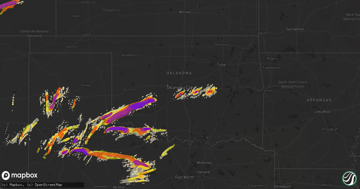
Hail Map on May 8, 2015
Get this storm
May 8 map
$229
one time, instant access
Download today. No call, no setup
Keep the $229
Bought the map and want the full workflow? Apply the entire $229 to a subscription within 7 days. None of it is wasted.
Every map, not just this one
This buys you this map. Subscription and you get every map we run, in the markets you choose from a few cities to whole states to nationwide. Plus real-time alerts the moment a storm fires.
Contact data
Name, contact info, occupancy, even credit band for addresses in the footprint. You go from where it hit to who to call.
Become the source they trust
Unlimited branding weather history reports on demand. You already have the documented answer ready for the property owner, and you are the one who showed up with it.
Property data and RoofTrace estimates
Pull up any address you have got, its value and the exact code rules for that jurisdiction, straight from One Click Code. Then RoofTrace estimates the squares, pitch, and roof value, priced the way you price.
States Impacted by Hail Map on May 8, 2015
Storm reports
New Mexico
| Date | Description |
|---|---|
| 05/08/20159:00 AM CDT | A local report indicates 1.75 inch wind near DORA |
Oklahoma
| Date | Description |
|---|---|
| 05/08/20156:56 PM CDT | Reported by kotv storm chaser. |
| 05/08/20156:55 PM CDT | Kwtv |
| 05/08/20156:16 PM CDT | A storm chaser reported a brief tornado. |
| 05/08/20156:04 PM CDT | Tornado reported near the interstate 44 and us-277 interchange west of randlett. Signs were damaged. |
| 05/08/20155:45 PM CDT | A local report indicates 1.50 inch wind near 3 NNE NORMAN |
| 05/08/20155:41 PM CDT | Hail has packed the roadways. |
| 05/08/20155:40 PM CDT | Hail measured just west of i-35 and south of tecumseh. |
| 05/08/20155:40 PM CDT | Rockcreek and sooner rd. |
| 05/08/20155:39 PM CDT | A local report indicates 2.75 inch wind near GRANDFIELD |
| 05/08/20155:35 PM CDT | A local report indicates 2.50 inch wind near 2 N NORMAN |
| 05/08/20155:35 PM CDT | A local report indicates 68 MPH wind near 2 NW NORMAN |
| 05/08/20155:35 PM CDT | 1e max westheimer airport. Also winds to 65 mph. |
| 05/08/20155:32 PM CDT | At robinson and flood. |
| 05/08/20155:32 PM CDT | At robinson and flood. |
| 05/08/20155:25 PM CDT | Power lines blown over near northwest 48th avenue and robinson street in northwest norman. |
| 05/08/20155:24 PM CDT | A local report indicates 1.00 inch wind near 6 S MOORE |
| 05/08/20155:17 PM CDT | A local report indicates 1.00 inch wind near 1 WSW NEWCASTLE |
| 05/08/20154:45 PM CDT | A local report indicates 2.75 inch wind near CARNEGIE |
| 05/08/20154:40 PM CDT | A local report indicates 1.25 inch wind near S CARNEGIE |
| 05/08/20154:20 PM CDT | A local report indicates 70 MPH wind near COOPERTON |
| 05/08/20154:00 PM CDT | A local report indicates 62 MPH wind near 4 SE HOBART |
| 05/08/20153:55 PM CDT | A local report indicates 64 MPH wind near 4 SE HOBART |
| 05/08/20153:50 PM CDT | Large tree down. Also railroad crossing guard down. |
| 05/08/20153:45 PM CDT | Grain bin destoyed. Also roof damage. |
| 05/08/20153:40 PM CDT | Also 43 mph wind measured. |
| 05/08/20153:25 PM CDT | A local report indicates 59 MPH wind near 5 SE MANGUM |
| 05/08/20153:20 PM CDT | A local report indicates 68 MPH wind near 5 SE MANGUM |
| 05/08/20153:14 PM CDT | A local report indicates 1.00 inch wind near MANGUM |
| 05/08/20152:00 PM CDT | Minor roof damage to one home... And siding damage to another. |
| 05/08/20151:48 PM CDT | A local report indicates 2.50 inch wind near MARTHA |
| 05/08/20151:42 PM CDT | A local report indicates 1.00 inch wind near BLAIR |
| 05/08/20151:39 PM CDT | A local report indicates 70 MPH wind near MARTHA |
| 05/08/20151:37 PM CDT | Quarter to golfball size hail. |
| 05/08/20151:04 PM CDT | A local report indicates 1.00 inch wind near GOULD |
| 05/08/201512:55 PM CDT | A local report indicates 1.00 inch wind near 1 W HOLLIS |
| 05/08/201512:50 PM CDT | A local report indicates 1.25 inch wind near HOLLIS |
| 05/07/20159:55 PM CDT | Mping report... Large tree limbs down |
| 05/07/20159:15 PM CDT | Trees down along belpine loop rd between idabel and broken bow. |
| 05/07/20159:04 PM CDT | Also torrential rainfall at coal and potontoc county line on highway 3. |
| 05/07/20158:55 PM CDT | Numerous power lines down on hwy 1. |
| 05/07/20158:30 PM CDT | A local report indicates 63 MPH wind near 4 NNE SULPHUR |
| 05/07/20158:25 PM CDT | 3 mile wide swath of damage from vanoss to union city. Trees and power lines down. A couple of sheds damaged. No injury or home damage reports. Estimated 50 to 60 mph w |
| 05/07/20158:20 PM CDT | A local report indicates 1.50 inch wind near OKEMAH |
| 05/07/20157:55 PM CDT | Oblong hail estimated to be 5 inches by 3 inches was photographed and sent on social media. |
| 05/07/20157:54 PM CDT | Wind gusts 30-40 mph. |
| 05/07/20157:08 PM CDT | Time and location estimated. |
| 05/07/20157:05 PM CDT | A local report indicates 59 MPH wind near DUNCAN |
Texas
| Date | Description |
|---|---|
| 05/08/20156:40 PM CDT | Tornado on the ground reported by sheriff office . |
| 05/08/20156:22 PM CDT | Public reported tornado on thr ground. |
| 05/08/20155:45 PM CDT | A local report indicates 70 MPH wind near ROCHESTER |
| 05/08/20155:30 PM CDT | A local report indicates 60 MPH wind near ROCHESTER |
| 05/08/20155:30 PM CDT | Trained spotter report relayed through haskell county sheriff office. Tornado was on the ground. |
| 05/08/20155:21 PM CDT | Storm chaser provided photograph. Minor damage to a metal outbuilding also reported. |
| 05/08/20155:20 PM CDT | Spotter reports wind damage to silo and trees between harold and electra... Winds estimated 80 to 90 mph. |
| 05/08/20155:00 PM CDT | Trees blown down onto road |
| 05/08/20154:28 PM CDT | Tornado developed about 4 miles northwest of lockett around 428 pm and moved to near lockett per law enforecement and storm chaser reports around 436 pm. Trees were dam |
| 05/08/20154:23 PM CDT | Spotter was located 6 wnw of vernon reporting brief tornado 4 miles to their west. Multiple brief funnels also reported. Report confirmed by law enforcement. |
| 05/08/20154:22 PM CDT | A local report indicates 66 MPH wind near 9 S CHILLICOTHE |
| 05/08/20153:20 PM CDT | West texas mesonet report |
| 05/08/20153:17 PM CDT | Hail at intersection of hwy 40 and 651 |
| 05/08/20152:38 PM CDT | A local report indicates 2.75 inch wind near RANSOM CANYON |
| 05/08/20152:32 PM CDT | A local report indicates 1.00 inch wind near 4 SSW RANSOM CANYON |
| 05/08/20152:31 PM CDT | Softball size hail around posey gin west of slaton. Reports of windows blown out |
| 05/08/20152:31 PM CDT | A local report indicates 3.00 inch wind near 10 SE LUBBOCK |
| 05/08/20152:29 PM CDT | 2 miles east of 87 on woodrow road |
| 05/08/20152:15 PM CDT | A local report indicates 1.00 inch wind near PETERSBURG |
| 05/08/201512:22 PM CDT | A local report indicates 2.50 inch wind near 5 E CHILDRESS |
| 05/08/201511:46 AM CDT | A local report indicates 1.50 inch wind near NORTHFIELD |
| 05/08/201511:22 AM CDT | A local report indicates 1.00 inch wind near MATADOR |
| 05/08/201510:56 AM CDT | Golf ball size hail near the plainview golf course relayed by plainview daily herald |
| 05/08/201510:44 AM CDT | A local report indicates 1.00 inch wind near FLOYDADA |
| 05/08/201510:41 AM CDT | Ham radio report relayed by nws amarillo |
| 05/08/201510:25 AM CDT | Quarter size hail in south side of hail center at the high school |
| 05/08/201510:14 AM CDT | A local report indicates 1.25 inch wind near COTTON CENTER |
| 05/08/201510:13 AM CDT | A local report indicates 1.75 inch wind near COTTON CENTER |
| 05/08/20159:47 AM CDT | A local report indicates 1.00 inch wind near ANTON |
| 05/08/20159:42 AM CDT | A local report indicates 1.75 inch wind near 2 S WHITHARRAL |
| 05/08/20159:10 AM CDT | A local report indicates 1.00 inch wind near OPDYKE WEST |
| 05/08/20156:35 AM CDT | Radar estimated time at 635am |
| 05/08/20155:40 AM CDT | Golf ball size in tascosa hills along with power being out. |
| 05/08/20155:40 AM CDT | Nickle to quarter size hail at bishop hills |
| 05/08/20155:40 AM CDT | Nickle to quarter size hail at bishop hills |
| 05/08/20155:25 AM CDT | A local report indicates 2.50 inch wind near 2 E BUSHLAND |
| 05/08/20155:00 AM CDT | Radar estimated time around 500am |
| 05/08/20154:45 AM CDT | Time estimated between 445am and 500am |
| 05/07/201511:28 PM CDT | Some of the hailstones were slightly larger than a quarter. |
| 05/07/201511:23 PM CDT | A local report indicates 1.00 inch wind near BIG SPRING |
| 05/07/201511:20 PM CDT | A local report indicates 1.75 inch wind near BRECKENRIDGE |
| 05/07/201510:45 PM CDT | The martin county so reported ping pong ball size hail on interstate 20 at mile marker 161. |
| 05/07/201510:43 PM CDT | A local report indicates 1.00 inch wind near ANDREWS |
| 05/07/201510:23 PM CDT | A local report indicates 1.00 inch wind near ALBANY |
| 05/07/201510:02 PM CDT | Tennis ball size hail reported from 1002 to 1007 pm cdt. |
| 05/07/20159:55 PM CDT | A local report indicates 2.00 inch wind near GREENWOOD |
| 05/07/20159:47 PM CDT | A local report indicates 2.00 inch wind near GREENWOOD |
| 05/07/20159:38 PM CDT | A local report indicates 1.25 inch wind near 1 S MIDLAND |
| 05/07/20159:32 PM CDT | A local report indicates 1.00 inch wind near VALLEY VIEW |
| 05/07/20159:29 PM CDT | A local report indicates 1.25 inch wind near 1 S MIDLAND |
| 05/07/20159:29 PM CDT | A local report indicates 1.75 inch wind near 1 SE MIDLAND |
| 05/07/20159:26 PM CDT | A local report indicates 1.00 inch wind near 1 S MIDLAND |
| 05/07/20159:16 PM CDT | Ping pong size hail on the east side of hubbard creek lake. |
| 05/07/20158:31 PM CDT | A local report indicates 1.75 inch wind near 4 E MIDKIFF |
| 05/07/20158:20 PM CDT | Golf ball size hail reported in midkiff between 820 and 825 pm cdt. |
| 05/07/20158:00 PM CDT | A local report indicates 1.00 inch wind near WOODSON |
| 05/07/20157:59 PM CDT | Glf ball hail 8 w of graham on fm 3109 |
| 05/07/20157:44 PM CDT | 66 mph wind gust measured by the bowie... Tx automated weather observation system |
| 05/07/20157:37 PM CDT | Numerous tree limbs down. |
| 05/07/20157:15 PM CDT | A local report indicates 1.50 inch wind near ELBERT |
| 05/07/20157:06 PM CDT | A local report indicates 1.75 inch wind near 4 SSW THROCKMORTON |
Indiana
| Date | Description |
|---|---|
| 05/08/20156:26 PM CDT | Old bank barn collapsed. Davis weather equipment measured 60mph wind. |
| 05/08/20154:20 PM CDT | Wind speeds of 60 to 65 mph estimated. Pea size hail also reported. |
| 05/08/20154:00 PM CDT | Several reports of tree and tree branches down in bourbon. A few trees onto homes and powerlines down. No injuries. |
| 05/08/20153:40 PM CDT | Tree snapped at the base and fell on a powerline |
Colorado
| Date | Description |
|---|---|
| 05/08/20154:47 PM CDT | A local report indicates 1.75 inch wind near 8 SSE BLENDE |
| 05/08/20154:24 PM CDT | A local report indicates 1.00 inch wind near 8 SSE BLENDE |
| 05/08/20153:30 PM CDT | A local report indicates 1.50 inch wind near 12 NE COLORADO CITY |
| 05/07/20157:30 PM CDT | A local report indicates 1.00 inch wind near LA JUNTA |
| 05/07/20157:24 PM CDT | A local report indicates 1.50 inch wind near 5 S CHERAW |
| 05/07/20157:20 PM CDT | A local report indicates 1.00 inch wind near LA JUNTA |
| 05/07/20157:15 PM CDT | A local report indicates 1.00 inch wind near LA JUNTA |
Illinois
| Date | Description |
|---|---|
| 05/08/20154:30 PM CDT | Six to eight inch diameter tree limbs down and shingles off a roof near ott and lorraine. Delayed report from facebook. |
| 05/08/20154:06 PM CDT | A local report indicates 61 MPH wind near 5 SSE OSWEGO |
| 05/08/20152:50 PM CDT | Estimated gusts up to 60 mph with heavy rain. |
| 05/08/20151:55 PM CDT | Several trees and utility cable television lines down near route 37. |
Cities Impacted by Hail Map on May 8, 2015
- Childress, TX
- Crosbyton, TX
- Midland, TX
- Friona, TX
- Gracemont, OK
- Fort Cobb, OK
- Big Lake, TX
- Garden City, TX
- Lubbock, TX
- Dodson, TX
- Petersburg, TX
- Floydada, TX
- Hereford, TX
- Quanah, TX
- Carnegie, OK
- Mountain View, OK
- Cordell, OK
- Okemah, OK
- Harrold, TX
- Grandfield, OK
- Davidson, OK
- Electra, TX
- Devol, OK
- Tucumcari, NM
- Snyder, TX
- Stanton, TX
- Adrian, TX
- Muleshoe, TX
- Quitaque, TX
- Vernon, TX
- Apache, OK
- La Junta, CO
- Macomb, OK
- Tecumseh, OK
- Rogers, NM
- Causey, NM
- Elida, NM
- Mustang, OK
- Breckenridge, TX
- Knox City, TX
- Seymour, TX
- Avondale, CO
- Rye, CO
- Pueblo, CO
- Boone, CO
- Big Spring, TX
- Wewoka, OK
- Abernathy, TX
- Gould, OK
- Mangum, OK
- Portales, NM
- Blair, OK
- Paducah, TX
- Hollis, OK
- Ransom Canyon, TX
- Slaton, TX
- Woodson, TX
- Amarillo, TX
- Blanchard, OK
- Oklahoma City, OK
- Norman, OK
- Newcastle, OK
- Flomot, TX
- Matador, TX
- Panhandle, TX
- Plainview, TX
- Oklaunion, TX
- Wildorado, TX
- Crowell, TX
- Canyon, TX
- Bryson, TX
- Graford, TX
- Tell, TX
- Albany, TX
- Hobart, OK
- Roosevelt, OK
- Lone Wolf, OK
- Chillicothe, TX
- Cisco, TX
- Mcadoo, TX
- Happy, TX
- Gotebo, OK
- Altus, OK
- Burkburnett, TX
- Iowa Park, TX
- Randlett, OK
- Loveland, OK
- Vega, TX
- Newcastle, TX
- Shawnee, OK
- Olustee, OK
- Duke, OK
- Throckmorton, TX
- Graham, TX
- Weleetka, OK
- Newalla, OK
- Mcloud, OK
- Wellington, TX
- Post, TX
- Ralls, TX
- Roaring Springs, TX
- Dimmitt, TX
- Moran, TX
- Abilene, TX
- Kress, TX
- El Reno, OK
- Colbert, OK
- Lorenzo, TX
- Eastland, TX
- Amherst, TX
- Levelland, TX
- Anton, TX
- Headrick, OK
- Claude, TX
- Prague, OK
- Mead, OK
- Calera, OK
- Lockney, TX
- Ranger, TX
- Aspermont, TX
- Munday, TX
- South Bend, TX
- O'Brien, TX
- Caddo, TX
- Dickens, TX
- Weinert, TX
- Old Glory, TX
- Haskell, TX
- Goree, TX
- Stamford, TX
- Olney, TX
- Spur, TX
- Rochester, TX
- Bowie, TX
- Bellevue, TX
- Cee Vee, TX
- Earlsboro, OK
- Meeker, OK
- Noble, OK
- Washington, OK
- Hydro, OK
- Littlefield, TX
- Hale Center, TX
- Idalou, TX
- Wetumka, OK
- Sheppard Afb, TX
- Wichita Falls, TX
- Sumner, TX
- Seminole, OK
- Wilson, TX
- Andrews, TX
- Midkiff, TX
- Morton, TX
- Las Animas, CO
- Rocky Ford, CO
- Eldorado, OK
- Memphis, TX
- Vinson, OK
- Anadarko, OK
- Granite, OK
- Turkey, TX
- Willow, OK
- Waurika, OK
- Ryan, OK
- Tulia, TX
- Summerfield, TX
- Texico, NM
- Temple, OK
- Hastings, OK
- Colorado City, CO
- Stephenville, TX
- Mingus, TX
- Gordon, TX
- Kit Carson, CO
- Holliday, TX
- Silverton, TX
- Harrah, OK
- Boley, OK
- Paden, OK
- Walters, OK
- Farwell, TX
- Wayside, TX
- Byers, TX
- Rocky, OK
- Honey Grove, TX
- Jacksboro, TX
- Loving, TX
- Jermyn, TX
- Walsenburg, CO
- Del Norte, CO
- Model, CO
- Fowler, CO
- Tuttle, OK
- Choctaw, OK
- Nocona, TX
- Montague, TX
- Altus Afb, OK
- Sterling, CO
- Olton, TX
- Beulah, CO
- Girard, TX
- Shallowater, TX
- Bovina, TX
- Pep, NM
- Brookston, TX
- Maud, OK
- Ordway, CO
- Castle, OK
- Holdenville, OK
- Shamrock, TX
- McCamey, TX
- Colorado Springs, CO
- Binger, OK
- Sidney, NE
- Frederick, OK
- Swink, CO
- Coahoma, TX
- Meadow, TX
- Whiteface, TX
- Clovis, NM