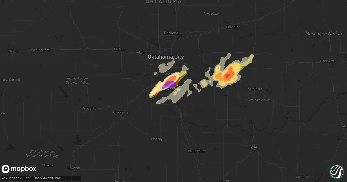
Hail Map in Norman, OK on May 8, 2015
Get this storm
May 8 map
$229
one time, instant access
Download today. No call, no setup
Keep the $229
Bought the map and want the full workflow? Apply the entire $229 to a subscription within 7 days. None of it is wasted.
Every map, not just this one
This buys you this map. Subscription and you get every map we run, in the markets you choose from a few cities to whole states to nationwide. Plus real-time alerts the moment a storm fires.
Contact data
Name, contact info, occupancy, even credit band for addresses in the footprint. You go from where it hit to who to call.
Become the source they trust
Unlimited branding weather history reports on demand. You already have the documented answer ready for the property owner, and you are the one who showed up with it.
Property data and RoofTrace estimates
Pull up any address you have got, its value and the exact code rules for that jurisdiction, straight from One Click Code. Then RoofTrace estimates the squares, pitch, and roof value, priced the way you price.
Storm reports in Norman, OK
Norman, OK
| Date | Description |
|---|---|
| 05/08/20155:45 PM CDT | A local report indicates 1.50 inch wind near 3 NNE NORMAN |
| 05/08/20155:40 PM CDT | Rockcreek and sooner rd. |
| 05/08/20155:40 PM CDT | Hail measured just west of i-35 and south of tecumseh. |
| 05/08/20155:35 PM CDT | 1e max westheimer airport. Also winds to 65 mph. |
| 05/08/20155:35 PM CDT | A local report indicates 68 MPH wind near 2 NW NORMAN |
| 05/08/20155:35 PM CDT | A local report indicates 2.50 inch wind near 2 N NORMAN |
| 05/08/20155:32 PM CDT | At robinson and flood. |
| 05/08/20155:32 PM CDT | At robinson and flood. |
| 05/08/20155:25 PM CDT | Power lines blown over near northwest 48th avenue and robinson street in northwest norman. |
| 05/08/20155:24 PM CDT | A local report indicates 1.00 inch wind near 6 S MOORE |
All States Impacted by Hail Map on May 8, 2015
All Cities Impacted by Hail Map on May 8, 2015
- Childress, TX
- Crosbyton, TX
- Midland, TX
- Friona, TX
- Gracemont, OK
- Fort Cobb, OK
- Big Lake, TX
- Garden City, TX
- Lubbock, TX
- Dodson, TX
- Petersburg, TX
- Floydada, TX
- Hereford, TX
- Quanah, TX
- Carnegie, OK
- Mountain View, OK
- Cordell, OK
- Okemah, OK
- Harrold, TX
- Grandfield, OK
- Davidson, OK
- Electra, TX
- Devol, OK
- Tucumcari, NM
- Snyder, TX
- Stanton, TX
- Adrian, TX
- Muleshoe, TX
- Quitaque, TX
- Vernon, TX
- Apache, OK
- La Junta, CO
- Macomb, OK
- Tecumseh, OK
- Rogers, NM
- Causey, NM
- Elida, NM
- Mustang, OK
- Breckenridge, TX
- Knox City, TX
- Seymour, TX
- Avondale, CO
- Rye, CO
- Pueblo, CO
- Boone, CO
- Big Spring, TX
- Wewoka, OK
- Abernathy, TX
- Gould, OK
- Mangum, OK
- Portales, NM
- Blair, OK
- Paducah, TX
- Hollis, OK
- Ransom Canyon, TX
- Slaton, TX
- Woodson, TX
- Amarillo, TX
- Blanchard, OK
- Oklahoma City, OK
- Norman, OK
- Newcastle, OK
- Flomot, TX
- Matador, TX
- Panhandle, TX
- Plainview, TX
- Oklaunion, TX
- Wildorado, TX
- Crowell, TX
- Canyon, TX
- Bryson, TX
- Graford, TX
- Tell, TX
- Albany, TX
- Hobart, OK
- Roosevelt, OK
- Lone Wolf, OK
- Chillicothe, TX
- Cisco, TX
- Mcadoo, TX
- Happy, TX
- Gotebo, OK
- Altus, OK
- Burkburnett, TX
- Iowa Park, TX
- Randlett, OK
- Loveland, OK
- Vega, TX
- Newcastle, TX
- Shawnee, OK
- Olustee, OK
- Duke, OK
- Throckmorton, TX
- Graham, TX
- Weleetka, OK
- Newalla, OK
- Mcloud, OK
- Wellington, TX
- Post, TX
- Ralls, TX
- Roaring Springs, TX
- Dimmitt, TX
- Moran, TX
- Abilene, TX
- Kress, TX
- El Reno, OK
- Colbert, OK
- Lorenzo, TX
- Eastland, TX
- Amherst, TX
- Levelland, TX
- Anton, TX
- Headrick, OK
- Claude, TX
- Prague, OK
- Mead, OK
- Calera, OK
- Lockney, TX
- Ranger, TX
- Aspermont, TX
- Munday, TX
- South Bend, TX
- O'Brien, TX
- Caddo, TX
- Dickens, TX
- Weinert, TX
- Old Glory, TX
- Haskell, TX
- Goree, TX
- Stamford, TX
- Olney, TX
- Spur, TX
- Rochester, TX
- Bowie, TX
- Bellevue, TX
- Cee Vee, TX
- Earlsboro, OK
- Meeker, OK
- Noble, OK
- Washington, OK
- Hydro, OK
- Littlefield, TX
- Hale Center, TX
- Idalou, TX
- Wetumka, OK
- Sheppard Afb, TX
- Wichita Falls, TX
- Sumner, TX
- Seminole, OK
- Wilson, TX
- Andrews, TX
- Midkiff, TX
- Morton, TX
- Las Animas, CO
- Rocky Ford, CO
- Eldorado, OK
- Memphis, TX
- Vinson, OK
- Anadarko, OK
- Granite, OK
- Turkey, TX
- Willow, OK
- Waurika, OK
- Ryan, OK
- Tulia, TX
- Summerfield, TX
- Texico, NM
- Temple, OK
- Hastings, OK
- Colorado City, CO
- Stephenville, TX
- Mingus, TX
- Gordon, TX
- Kit Carson, CO
- Holliday, TX
- Silverton, TX
- Harrah, OK
- Boley, OK
- Paden, OK
- Walters, OK
- Farwell, TX
- Wayside, TX
- Byers, TX
- Rocky, OK
- Honey Grove, TX
- Jacksboro, TX
- Loving, TX
- Jermyn, TX
- Walsenburg, CO
- Del Norte, CO
- Model, CO
- Fowler, CO
- Tuttle, OK
- Choctaw, OK
- Nocona, TX
- Montague, TX
- Altus Afb, OK
- Sterling, CO
- Olton, TX
- Beulah, CO
- Girard, TX
- Shallowater, TX
- Bovina, TX
- Pep, NM
- Brookston, TX
- Maud, OK
- Ordway, CO
- Castle, OK
- Holdenville, OK
- Shamrock, TX
- McCamey, TX
- Colorado Springs, CO
- Binger, OK
- Sidney, NE
- Frederick, OK
- Swink, CO
- Coahoma, TX
- Meadow, TX
- Whiteface, TX
- Clovis, NM


