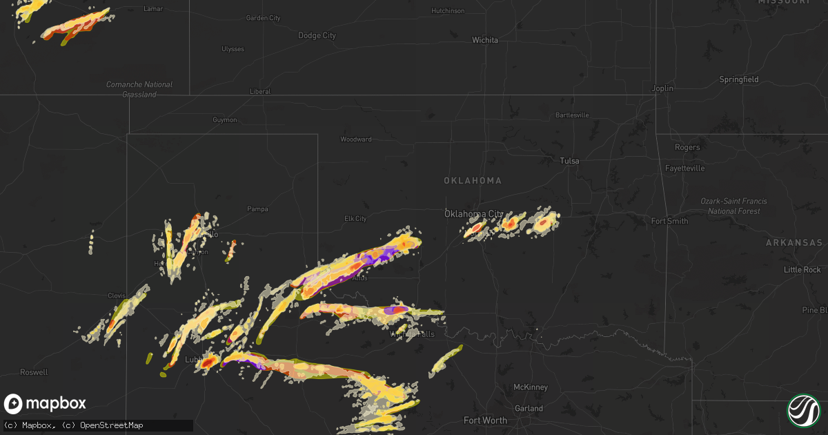
Hail Map in Oklahoma on May 8, 2015
Get this storm
May 8 map
$229
one time, instant access
Download today. No call, no setup
Keep the $229
Bought the map and want the full workflow? Apply the entire $229 to a subscription within 7 days. None of it is wasted.
Every map, not just this one
This buys you this map. Subscription and you get every map we run, in the markets you choose from a few cities to whole states to nationwide. Plus real-time alerts the moment a storm fires.
Contact data
Name, contact info, occupancy, even credit band for addresses in the footprint. You go from where it hit to who to call.
Become the source they trust
Unlimited branding weather history reports on demand. You already have the documented answer ready for the property owner, and you are the one who showed up with it.
Property data and RoofTrace estimates
Pull up any address you have got, its value and the exact code rules for that jurisdiction, straight from One Click Code. Then RoofTrace estimates the squares, pitch, and roof value, priced the way you price.
Storm reports in Oklahoma
Oklahoma
| Date | Description |
|---|---|
| 05/08/20156:56 PM CDT | Reported by kotv storm chaser. |
| 05/08/20156:55 PM CDT | Kwtv |
| 05/08/20156:16 PM CDT | A storm chaser reported a brief tornado. |
| 05/08/20156:04 PM CDT | Tornado reported near the interstate 44 and us-277 interchange west of randlett. Signs were damaged. |
| 05/08/20155:45 PM CDT | A local report indicates 1.50 inch wind near 3 NNE NORMAN |
| 05/08/20155:41 PM CDT | Hail has packed the roadways. |
| 05/08/20155:40 PM CDT | Hail measured just west of i-35 and south of tecumseh. |
| 05/08/20155:40 PM CDT | Rockcreek and sooner rd. |
| 05/08/20155:39 PM CDT | A local report indicates 2.75 inch wind near GRANDFIELD |
| 05/08/20155:35 PM CDT | A local report indicates 2.50 inch wind near 2 N NORMAN |
| 05/08/20155:35 PM CDT | A local report indicates 68 MPH wind near 2 NW NORMAN |
| 05/08/20155:35 PM CDT | 1e max westheimer airport. Also winds to 65 mph. |
| 05/08/20155:32 PM CDT | At robinson and flood. |
| 05/08/20155:32 PM CDT | At robinson and flood. |
| 05/08/20155:25 PM CDT | Power lines blown over near northwest 48th avenue and robinson street in northwest norman. |
| 05/08/20155:24 PM CDT | A local report indicates 1.00 inch wind near 6 S MOORE |
| 05/08/20155:17 PM CDT | A local report indicates 1.00 inch wind near 1 WSW NEWCASTLE |
| 05/08/20154:45 PM CDT | A local report indicates 2.75 inch wind near CARNEGIE |
| 05/08/20154:40 PM CDT | A local report indicates 1.25 inch wind near S CARNEGIE |
| 05/08/20154:20 PM CDT | A local report indicates 70 MPH wind near COOPERTON |
| 05/08/20154:00 PM CDT | A local report indicates 62 MPH wind near 4 SE HOBART |
| 05/08/20153:55 PM CDT | A local report indicates 64 MPH wind near 4 SE HOBART |
| 05/08/20153:50 PM CDT | Large tree down. Also railroad crossing guard down. |
| 05/08/20153:45 PM CDT | Grain bin destoyed. Also roof damage. |
| 05/08/20153:40 PM CDT | Also 43 mph wind measured. |
| 05/08/20153:25 PM CDT | A local report indicates 59 MPH wind near 5 SE MANGUM |
| 05/08/20153:20 PM CDT | A local report indicates 68 MPH wind near 5 SE MANGUM |
| 05/08/20153:14 PM CDT | A local report indicates 1.00 inch wind near MANGUM |
| 05/08/20152:00 PM CDT | Minor roof damage to one home... And siding damage to another. |
| 05/08/20151:48 PM CDT | A local report indicates 2.50 inch wind near MARTHA |
| 05/08/20151:42 PM CDT | A local report indicates 1.00 inch wind near BLAIR |
| 05/08/20151:39 PM CDT | A local report indicates 70 MPH wind near MARTHA |
| 05/08/20151:37 PM CDT | Quarter to golfball size hail. |
| 05/08/20151:04 PM CDT | A local report indicates 1.00 inch wind near GOULD |
| 05/08/201512:55 PM CDT | A local report indicates 1.00 inch wind near 1 W HOLLIS |
| 05/08/201512:50 PM CDT | A local report indicates 1.25 inch wind near HOLLIS |
| 05/07/20159:55 PM CDT | Mping report... Large tree limbs down |
| 05/07/20159:15 PM CDT | Trees down along belpine loop rd between idabel and broken bow. |
| 05/07/20159:04 PM CDT | Also torrential rainfall at coal and potontoc county line on highway 3. |
| 05/07/20158:55 PM CDT | Numerous power lines down on hwy 1. |
| 05/07/20158:30 PM CDT | A local report indicates 63 MPH wind near 4 NNE SULPHUR |
| 05/07/20158:25 PM CDT | 3 mile wide swath of damage from vanoss to union city. Trees and power lines down. A couple of sheds damaged. No injury or home damage reports. Estimated 50 to 60 mph w |
| 05/07/20158:20 PM CDT | A local report indicates 1.50 inch wind near OKEMAH |
| 05/07/20157:55 PM CDT | Oblong hail estimated to be 5 inches by 3 inches was photographed and sent on social media. |
| 05/07/20157:54 PM CDT | Wind gusts 30-40 mph. |
| 05/07/20157:08 PM CDT | Time and location estimated. |
| 05/07/20157:05 PM CDT | A local report indicates 59 MPH wind near DUNCAN |
All States Impacted by Hail Map on May 8, 2015
Cities Impacted by Hail Map on May 8, 2015
- Childress, TX
- Crosbyton, TX
- Midland, TX
- Friona, TX
- Gracemont, OK
- Fort Cobb, OK
- Big Lake, TX
- Garden City, TX
- Lubbock, TX
- Dodson, TX
- Petersburg, TX
- Floydada, TX
- Hereford, TX
- Quanah, TX
- Carnegie, OK
- Mountain View, OK
- Cordell, OK
- Okemah, OK
- Harrold, TX
- Grandfield, OK
- Davidson, OK
- Electra, TX
- Devol, OK
- Tucumcari, NM
- Snyder, TX
- Stanton, TX
- Adrian, TX
- Muleshoe, TX
- Quitaque, TX
- Vernon, TX
- Apache, OK
- La Junta, CO
- Macomb, OK
- Tecumseh, OK
- Rogers, NM
- Causey, NM
- Elida, NM
- Mustang, OK
- Breckenridge, TX
- Knox City, TX
- Seymour, TX
- Avondale, CO
- Rye, CO
- Pueblo, CO
- Boone, CO
- Big Spring, TX
- Wewoka, OK
- Abernathy, TX
- Gould, OK
- Mangum, OK
- Portales, NM
- Blair, OK
- Paducah, TX
- Hollis, OK
- Ransom Canyon, TX
- Slaton, TX
- Woodson, TX
- Amarillo, TX
- Blanchard, OK
- Oklahoma City, OK
- Norman, OK
- Newcastle, OK
- Flomot, TX
- Matador, TX
- Panhandle, TX
- Plainview, TX
- Oklaunion, TX
- Wildorado, TX
- Crowell, TX
- Canyon, TX
- Bryson, TX
- Graford, TX
- Tell, TX
- Albany, TX
- Hobart, OK
- Roosevelt, OK
- Lone Wolf, OK
- Chillicothe, TX
- Cisco, TX
- Mcadoo, TX
- Happy, TX
- Gotebo, OK
- Altus, OK
- Burkburnett, TX
- Iowa Park, TX
- Randlett, OK
- Loveland, OK
- Vega, TX
- Newcastle, TX
- Shawnee, OK
- Olustee, OK
- Duke, OK
- Throckmorton, TX
- Graham, TX
- Weleetka, OK
- Newalla, OK
- Mcloud, OK
- Wellington, TX
- Post, TX
- Ralls, TX
- Roaring Springs, TX
- Dimmitt, TX
- Moran, TX
- Abilene, TX
- Kress, TX
- El Reno, OK
- Colbert, OK
- Lorenzo, TX
- Eastland, TX
- Amherst, TX
- Levelland, TX
- Anton, TX
- Headrick, OK
- Claude, TX
- Prague, OK
- Mead, OK
- Calera, OK
- Lockney, TX
- Ranger, TX
- Aspermont, TX
- Munday, TX
- South Bend, TX
- O'Brien, TX
- Caddo, TX
- Dickens, TX
- Weinert, TX
- Old Glory, TX
- Haskell, TX
- Goree, TX
- Stamford, TX
- Olney, TX
- Spur, TX
- Rochester, TX
- Bowie, TX
- Bellevue, TX
- Cee Vee, TX
- Earlsboro, OK
- Meeker, OK
- Noble, OK
- Washington, OK
- Hydro, OK
- Littlefield, TX
- Hale Center, TX
- Idalou, TX
- Wetumka, OK
- Sheppard Afb, TX
- Wichita Falls, TX
- Sumner, TX
- Seminole, OK
- Wilson, TX
- Andrews, TX
- Midkiff, TX
- Morton, TX
- Las Animas, CO
- Rocky Ford, CO
- Eldorado, OK
- Memphis, TX
- Vinson, OK
- Anadarko, OK
- Granite, OK
- Turkey, TX
- Willow, OK
- Waurika, OK
- Ryan, OK
- Tulia, TX
- Summerfield, TX
- Texico, NM
- Temple, OK
- Hastings, OK
- Colorado City, CO
- Stephenville, TX
- Mingus, TX
- Gordon, TX
- Kit Carson, CO
- Holliday, TX
- Silverton, TX
- Harrah, OK
- Boley, OK
- Paden, OK
- Walters, OK
- Farwell, TX
- Wayside, TX
- Byers, TX
- Rocky, OK
- Honey Grove, TX
- Jacksboro, TX
- Loving, TX
- Jermyn, TX
- Walsenburg, CO
- Del Norte, CO
- Model, CO
- Fowler, CO
- Tuttle, OK
- Choctaw, OK
- Nocona, TX
- Montague, TX
- Altus Afb, OK
- Sterling, CO
- Olton, TX
- Beulah, CO
- Girard, TX
- Shallowater, TX
- Bovina, TX
- Pep, NM
- Brookston, TX
- Maud, OK
- Ordway, CO
- Castle, OK
- Holdenville, OK
- Shamrock, TX
- McCamey, TX
- Colorado Springs, CO
- Binger, OK
- Sidney, NE
- Frederick, OK
- Swink, CO
- Coahoma, TX
- Meadow, TX
- Whiteface, TX
- Clovis, NM


