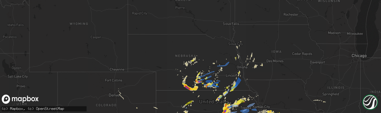
Hail Map in Nebraska on April 29, 2022
The weather event in Nebraska on April 29, 2022 includes Hail, Wind, and Tornado maps. 8 states and 592 cities were impacted and suffered possible damage. The total estimated number of properties impacted is 23,686.
Want more than just the map?
Turn this storm into a full workflow.
- Owner + property data so you know who to knock
- OnDemand branded weather history reports to win the "did we even have hail?" argument
- RoofTrace estimate so reps stop guessing numbers at the door
Bought this map? Upgrade within 7 days and we'll credit the $230. (10-15 min setup call)
Hail
Wind
Tornado
23,686
Estimated number of impacted properties by a 1.00" hail or larger10,708
Estimated number of impacted properties by a 1.75" hail or larger2,226
Estimated number of impacted properties by a 2.50" hail or largerStorm reports in Nebraska
Nebraska
| Date | Description |
|---|---|
| 04/29/20226:59 PM CDT | Grain bins destroyed and also a nearby outbuilding. Time estimated from radar. |
| 04/29/20226:55 PM CDT | Pea to quarter size hail reported in nelson via facebook. |
| 04/29/20226:54 PM CDT | Corrects previous tstm wnd dmg report from minden. Social media photos of at least one large evergreen tree uprooted in town. Time estimated based on radar. |
| 04/29/20226:54 PM CDT | Social media photos of at least one tree down in town. Diameter of tree unknown. Time estimated based on radar. |
| 04/29/20226:53 PM CDT | A local report indicates 66 MPH wind near 1 N CLAY CENTER |
| 04/29/20226:52 PM CDT | Multiple trees and powerlines down in town. Time estimated from radar. |
| 04/29/20226:52 PM CDT | Updates previous tstm wnd dmg report from harvard. Multiple trees and powerlines down in town. Time estimated from radar. Additional info is that some trees were 2 ft. |
| 04/29/20226:49 PM CDT | A local report indicates 63 MPH wind near 4 NNW BOSTWICK |
| 04/29/20226:46 PM CDT | Report of pickup getting pushed slightly sideways. |
| 04/29/20226:46 PM CDT | Corrects previous tstm wnd gst report from 4 e pauline. Corrected time. |
| 04/29/20226:41 PM CDT | A local report indicates 65 MPH wind near 4 NE TRUMBULL |
| 04/29/20226:35 PM CDT | Report via amateur radio. Ongoing at the time of the report. |
| 04/29/20226:34 PM CDT | Trained spotter reported grain bin blown between a house and workshop. Damage to the shop in addition to a hydrant and fence. |
| 04/29/20226:33 PM CDT | A local report indicates 62 MPH wind near 4 WNW GLENVIL |
| 04/29/20226:33 PM CDT | A local report indicates 60 MPH wind near GLENVIL |
| 04/29/20226:30 PM CDT | Estimated winds to at least 60 mph blew a small backyard shed into the front yard. Time estimated from radar. |
| 04/29/20226:28 PM CDT | A local report indicates 64 MPH wind near 3 NE AYR |
| 04/29/20226:26 PM CDT | Social media report. |
| 04/29/20226:15 PM CDT | Report via social media. |
| 04/29/20226:15 PM CDT | Heavy rain with the hail. |
| 04/29/20226:14 PM CDT | A local report indicates 1.00 inch wind near DILLER |
| 04/29/20226:12 PM CDT | 50 to 60 mph wind gusts at wood river. |
| 04/29/20226:07 PM CDT | Report of quarter size hail relayed via amateur radio. |
| 04/29/20226:00 PM CDT | Public report via social media. |
| 04/29/20226:00 PM CDT | Measured at north platte airport |
| 04/29/20225:59 PM CDT | Itchell ks 3953 9830 |
| 04/29/20225:59 PM CDT | A local report indicates 72 MPH wind near 4 WSW WOOD RIVER |
| 04/29/20225:57 PM CDT | A local report indicates 70 MPH wind near 3 ENE HEARTWELL |
| 04/29/20225:55 PM CDT | Gust to 70mph. |
| 04/29/20225:55 PM CDT | Public report via social media. |
| 04/29/20225:50 PM CDT | Updated to previous tstm wnd dmg report from 2 wsw shelton. Railroad communications stated 15 cars were derailed on westbound track... Causing train traffic on both lin |
| 04/29/20225:50 PM CDT | Train cars derailed in this general area by strong winds. Unknown how many cars. Time estimated from radar. |
| 04/29/20225:49 PM CDT | Ping pong ball size hail ongoing in minden. 60 mph wind gust also measured. |
| 04/29/20225:47 PM CDT | Measured at north platte airport |
| 04/29/20225:44 PM CDT | At rock creek station... Ne. |
| 04/29/20225:44 PM CDT | Social media photos and video of brief tornado in a field. |
| 04/29/20225:40 PM CDT | Itchell ks 3945 9819 |
| 04/29/20225:40 PM CDT | Nebraska mesonet site. |
| 04/29/20225:39 PM CDT | Social media report of hail. |
| 04/29/20225:37 PM CDT | A local report indicates 66 MPH wind near 6 ENE KEARNEY |
| 04/29/20225:30 PM CDT | Photo received via facebook. Time estimated from radar. |
| 04/29/20225:15 PM CDT | Report of a brief tornado... Followed by supporting photo via facebook. Location estimated. |
| 04/29/20225:15 PM CDT | Broadcast media reported golfball size hail via social media. |
| 04/29/20225:15 PM CDT | Photo received via facebook. |
| 04/29/20225:12 PM CDT | Social media photo. Time estimated from radar. |
| 04/29/20225:11 PM CDT | Social media report of golfball size hail. |
| 04/29/20225:10 PM CDT | Social media report and photo. |
| 04/29/20225:10 PM CDT | Social media report. |
| 04/29/20225:10 PM CDT | Social media report and photo of quarter size hail. |
| 04/29/20225:03 PM CDT | Mping report of quarter sized hail. |
| 04/29/20225:03 PM CDT | A local report indicates 61 MPH wind near BERTRAND |
| 04/29/20224:55 PM CDT | Various reports of a dusty ground circulation near road 704 and road b. |
| 04/29/20224:54 PM CDT | Photo received via facebook. |
| 04/29/20224:47 PM CDT | Pea to quarter sized hail. |
| 04/29/20224:30 PM CDT | Delayed report. Hail covered the ground with largest hailstones the size of a quarter. Time estimated by radar. |
| 04/29/20224:30 PM CDT | Social media photo of 2.5 in measured hail. Also photo of bruised leg from hailstone. |
| 04/29/20224:20 PM CDT | Ping pong to golf ball size hail at dispatch. |
| 04/29/20224:05 PM CDT | Pea to golf ball size hail started at 405...a few small stones still falling now. |
| 04/29/20224:05 PM CDT | Estimated from picture on facebook. |
| 04/29/20224:01 PM CDT | Hail still falling at arapahoe golf course. Golf balls with a few eggs |
| 04/29/20223:48 PM CDT | Ping pong to golf ball sized hail reported at the arapahoe golf course. |
| 04/29/20223:43 PM CDT | Corrects previous hail report from 5 s holbrook. Hail measured 2.7 inches in diameter. Photo via facebook. |
| 04/29/20223:43 PM CDT | Hail was at least tennis ball size. Photo via facebook. |
| 04/29/20227:42 AM CDT | At 1242 AM CDT, a severe thunderstorm was located near Holbrook, or 31 miles south of Lexington, moving north at 10 mph. HAZARD...Quarter size hail. SOURCE...Radar indicated. IMPACT...Damage to vehicles is expected. This severe thunderstorm will remain over mainly rural areas of southern Gosper and northwestern Furnas Counties. |
| 04/29/20223:35 AM CDT | At 835 PM CDT, severe thunderstorms were located along a line extending from 3 miles west of Reserve to near Horton to 5 miles south of Whiting, moving northeast at 25 mph. HAZARD...60 mph wind gusts and nickel size hail. SOURCE...Radar indicated. IMPACT...Expect damage to roofs, siding, and trees. Locations impacted include... Hiawatha, Horton, Everest, Robinson, Whiting, Reserve, Powhattan, Hamlin and Willis. |
| 04/29/20223:26 AM CDT | At 825 PM CDT, a severe thunderstorm was located over Louisville, or 20 miles south of Omaha, moving northeast at 30 mph. HAZARD...70 mph wind gusts and half dollar size hail. SOURCE...Radar indicated. IMPACT...Hail damage to vehicles is expected. Expect considerable tree damage. Wind damage is also likely to mobile homes, roofs, and outbuildings. This severe thunderstorm will be near... Cedar Creek around 835 PM CDT. Springfield around 840 PM CDT.Other locations in the path of this severe thunderstorm include Omaha, Papillion, Offutt AFB, Bellevue, La Vista, Ralston, Council Bluffs and Underwood.This includes the following highways... Interstate 29 between mile markers 35 and 63. Interstate 80 in Iowa between mile markers 1 and 17. Interstate 80 in Nebraska between mile markers 432 and 454. |
| 04/29/20223:08 AM CDT | At 808 PM CDT, severe thunderstorms were located along a line extending from Panama to near Douglas to 5 miles east of Sterling, moving northeast at 55 mph. HAZARD...70 mph wind gusts and half dollar size hail. SOURCE...Radar indicated. IMPACT...Hail damage to vehicles is expected. Expect considerable tree damage. Wind damage is also likely to mobile homes, roofs, and outbuildings. Severe thunderstorms will be near... Palmyra around 815 PM CDT. Unadilla around 820 PM CDT. Syracuse around 825 PM CDT.Other locations in the path of these severe thunderstorms includeElmwood, Weeping Water, Avoca, Murdock, Nehawka and Murray.This includes Interstate 80 in Nebraska between mile markers 414 and418. |
| 04/29/20223:07 AM CDT | At 807 PM CDT, severe thunderstorms were located along a line extending from 6 miles north of Schuyler to Garland, moving northeast at 40 mph. HAZARD...60 mph wind gusts. SOURCE...Radar indicated. IMPACT...Expect damage to roofs, siding, and trees. Severe thunderstorms will be near... Schuyler around 810 PM CDT. Dwight around 815 PM CDT. Valparaiso around 825 PM CDT.Other locations in the path of these severe thunderstorms includeWahoo and Hooper. |
| 04/29/20223:02 AM CDT | At 802 PM CDT, a severe thunderstorm was located over Howells, or 25 miles northeast of Columbus, moving north at 30 mph. HAZARD...Ping pong ball size hail and 60 mph wind gusts. SOURCE...Radar indicated. IMPACT...People and animals outdoors will be injured. Expect hail damage to roofs, siding, windows, and vehicles. Expect wind damage to roofs, siding, and trees. Locations impacted include... Stanton and Pilger. |
| 04/29/20222:58 AM CDT | At 756 PM CDT, a severe thunderstorm was located 10 miles northwest of Pawnee City, or 25 miles east of Beatrice, moving northeast at 45 mph. THIS IS A DESTRUCTIVE STORM FOR TECUMSEH, ELK CREEK, AND STEINAUER. HAZARD...80 mph wind gusts and half dollar size hail. SOURCE...Trained weather spotters. At 755 PM an 81 mph wind gust was measured in Lewiston. IMPACT...Flying debris will be dangerous to those caught without shelter. Mobile homes will be heavily damaged. Expect considerable damage to roofs, windows, and vehicles. Extensive tree damage and power outages are likely. This severe thunderstorm will be near... Table Rock around 805 PM CDT. Tecumseh around 810 PM CDT.Other locations in the path of this severe thunderstorm includeJohnson. |
| 04/29/20222:41 AM CDT | At 740 PM CDT, a severe thunderstorm was located near Columbus, moving east at 55 mph. HAZARD...60 mph wind gusts. SOURCE...Radar indicated. IMPACT...Expect damage to roofs, siding, and trees. This severe thunderstorm will be near... Schuyler around 755 PM CDT.Other locations in the path of this severe thunderstorm include NorthBend. |
| 04/29/20222:31 AM CDT | At 730 PM CDT, severe thunderstorms were located along a line extending from 5 miles southeast of Duncan to 4 miles west of Milligan, moving east at 45 mph. HAZARD...60 mph wind gusts and nickel size hail. SOURCE...Radar indicated. IMPACT...Expect damage to roofs, siding, and trees. Severe thunderstorms will be near... Bellwood around 745 PM CDT. David City and Western around 750 PM CDT.Other locations in the path of these severe thunderstorms includeWilber and De Witt.This includes Interstate 80 in Nebraska between mile markers 366 and388. |
| 04/29/20222:22 AM CDT | At 721 PM CDT, a severe thunderstorm was located near Lindsay, or 23 miles southwest of Norfolk, moving northeast at 35 mph. HAZARD...60 mph wind gusts. SOURCE...Radar indicated. IMPACT...Expect damage to roofs, siding, and trees. This severe thunderstorm will be near... Madison around 740 PM CDT.Other locations in the path of this severe thunderstorm includeCreston and Stanton. |
| 04/29/20222:15 AM CDT | At 715 PM CDT, severe thunderstorms were located along a line extending from near Genoa to near Polk to near Grafton, moving east at 45 mph. HAZARD...70 mph wind gusts and nickel size hail. SOURCE...Radar indicated. IMPACT...Expect considerable tree damage. Damage is likely to mobile homes, roofs, and outbuildings. Severe thunderstorms will be near... Stromsburg and Lushton around 720 PM CDT. York, McCool Junction and Benedict around 725 PM CDT. Waco and Gresham around 735 PM CDT.This includes Interstate 80 between mile markers 325 and 365. |
| 04/29/20222:14 AM CDT | At 713 PM CDT, a severe thunderstorm was located 8 miles southeast of Pickrell, or 9 miles east of Beatrice, moving northeast at 40 mph. HAZARD...60 mph wind gusts and half dollar size hail. SOURCE...Radar indicated. IMPACT...Hail damage to vehicles is expected. Expect wind damage to roofs, siding, and trees. Locations impacted include... Sterling. |
| 04/29/20222:01 AM CDT | At 700 PM CDT, a severe thunderstorm was located over Genoa, or 18 miles west of Columbus, moving east at 45 mph. HAZARD...60 mph wind gusts. SOURCE...Radar indicated. IMPACT...Expect damage to roofs, siding, and trees. This severe thunderstorm will be near... Monroe around 705 PM CDT. Platte Center around 715 PM CDT. Columbus around 720 PM CDT. |
| 04/29/20221:42 AM CDT | At 641 PM CDT, severe thunderstorms were located along a line extending from 7 miles west of Fullerton to Chapman, moving east at 45 mph. HAZARD...60 mph wind gusts and nickel size hail. SOURCE...Radar indicated. IMPACT...Expect damage to roofs, siding, and trees. Severe thunderstorms will be near... Central City and Fullerton around 655 PM CDT. Hordville around 700 PM CDT.Other locations in the path of these severe thunderstorms includeGenoa, Clarks and Polk. |
| 04/29/20221:21 AM CDT | At 620 PM CDT, severe thunderstorms were located along a line extending from St. Libory to Doniphan to near Ayr to near Bladen, moving east at 35 mph. HAZARD...70 mph wind gusts and nickel size hail. SOURCE...Radar indicated. IMPACT...Expect considerable tree damage. Damage is likely to mobile homes, roofs, and outbuildings. Severe thunderstorms will be near... Trumbull around 630 PM CDT. Glenvil around 635 PM CDT. Giltner, Chapman and Rosemont around 640 PM CDT.Other locations in the path of these severe thunderstorms includeHarvard, Fairfield, Lawrence, Marquette, Clay Center, Deweese,Stockham, Edgar, Nelson, Saronville, Sutton and Henderson.This includes Interstate 80 between mile markers 307 and 345. |
| 04/29/202212:51 AM CDT | At 551 PM CDT, a severe thunderstorm was located over North Platte, moving east at 20 mph. HAZARD...60 mph wind gusts. SOURCE...Radar indicated. IMPACT...Expect damage to roofs, siding, and trees. Locations impacted include... North Platte, Brady, Maxwell, Lake Maloney State Recreation Area, North Platte Airport, Keith, Cottonwood Canyon State Wildlife Management Area, Jeffrey Canyon State Wildlife Management Area, Birdwood and Vroman.This includes the following highways... Highway 97 between mile markers 1 and 16. Interstate 80 in Nebraska between mile markers 170 and 208. Highway 83 between mile markers 69 and 105. |
| 04/29/202212:48 AM CDT | At 547 PM CDT, severe thunderstorms were located along a line extending from near Boelus to Shelton to near Minden, moving east at 30 mph. HAZARD...70 mph wind gusts and half dollar size hail. SOURCE...Radar indicated. IMPACT...Hail damage to vehicles is expected. Expect considerable tree damage. Wind damage is also likely to mobile homes, roofs, and outbuildings. Severe thunderstorms will be near... Wood River and Cairo around 600 PM CDT. Prosser around 605 PM CDT.Other locations in the path of these severe thunderstorms includeHolstein, Roseland, Hastings, Doniphan, Hansen, St. Libory, GrandIsland and Ayr.This includes Interstate 80 between mile markers 285 and 317. |
| 04/29/202212:37 AM CDT | At 537 PM CDT, severe thunderstorms were located along a line extending from near Funk to near Ragan to near Huntley, moving east at 40 mph. HAZARD...Ping pong ball size hail. SOURCE...Radar indicated. IMPACT...People and animals outdoors will be injured. Expect damage to roofs, siding, windows, and vehicles. Severe thunderstorms will be near... Wilcox around 545 PM CDT. Axtell and Hildreth around 550 PM CDT.Other locations in the path of these severe thunderstorms includeMinden, Upland, Campbell and Norman. |
| 04/29/202212:32 AM CDT | At 531 PM CDT, a severe thunderstorm was located near Pleasanton, or 20 miles north of Kearney, moving east at 15 mph. HAZARD...60 mph wind gusts and quarter size hail. SOURCE...Radar indicated. IMPACT...Hail damage to vehicles is expected. Expect wind damage to roofs, siding, and trees. This severe thunderstorm will be near... Pleasanton around 540 PM CDT.Other locations in the path of this severe thunderstorm includeRavenna and Poole. |
| 04/29/202212:17 AM CDT | At 517 PM CDT, a severe thunderstorm was located over Woodruff, or 19 miles north of Phillipsburg, moving southeast at 35 mph. HAZARD...Golf ball size hail and 60 mph wind gusts. SOURCE...Radar indicated. IMPACT...People and animals outdoors will be injured. Expect hail damage to roofs, siding, windows, and vehicles. Expect wind damage to roofs, siding, and trees. This severe thunderstorm will be near... Alma and Woodruff around 520 PM CDT.Other locations in the path of this severe thunderstorm includeKensington. |
| 04/29/202212:10 AM CDT | At 509 PM CDT, a severe thunderstorm was located over Kearney, moving northeast at 25 mph. HAZARD...Ping pong ball size hail and 60 mph wind gusts. SOURCE...Radar indicated. IMPACT...People and animals outdoors will be injured. Expect hail damage to roofs, siding, windows, and vehicles. Expect wind damage to roofs, siding, and trees. Locations impacted include... Gibbon and Shelton.This includes Interstate 80 between mile markers 268 and 292. |
| 04/29/202212:08 AM CDT | At 508 PM CDT, a severe thunderstorm was located over Axtell, or 13 miles east of Holdrege, moving east at 20 mph. HAZARD...Ping pong ball size hail and 60 mph wind gusts. SOURCE...Radar indicated. IMPACT...People and animals outdoors will be injured. Expect hail damage to roofs, siding, windows, and vehicles. Expect wind damage to roofs, siding, and trees. Locations impacted include... Minden, Norman and Heartwell.This includes Interstate 80 between mile markers 281 and 286. |
| 04/29/202212:03 AM CDT | At 503 PM CDT, severe thunderstorms were located along a line extending from near Taylor to near Arcadia to 7 miles south of Mason City, moving east at 45 mph. HAZARD...60 mph wind gusts and quarter size hail. SOURCE...Radar indicated. IMPACT...Hail damage to vehicles is expected. Expect wind damage to roofs, siding, and trees. Severe thunderstorms will be near... Arcadia around 510 PM CDT. Litchfield around 515 PM CDT. Hazard around 520 PM CDT.Other locations in the path of these severe thunderstorms includeLoup City, Elyria, Fort Hartsuff State Park, Ord, Sherman ReservoirDam, Ashton and Rockville. |
| 04/29/202212:00 AM CDT | At 500 PM CDT, severe thunderstorms were located along a line extending from Eddyville to 6 miles northeast of Smithfield to near Edison, moving east at 40 mph. HAZARD...60 mph wind gusts and quarter size hail. SOURCE...Radar indicated. IMPACT...Hail damage to vehicles is expected. Expect wind damage to roofs, siding, and trees. Severe thunderstorms will be near... Overton and Sumner around 510 PM CDT. Oxford around 515 PM CDT. Miller around 520 PM CDT.Other locations in the path of these severe thunderstorms include ElmCreek, Odessa and Huntley.This includes Interstate 80 between mile markers 237 and 266. |
| 04/28/202211:38 PM CDT | At 438 PM CDT, a severe thunderstorm was located near Weissert, or 7 miles northeast of Broken Bow, moving east at 45 mph. HAZARD...60 mph wind gusts and quarter size hail. SOURCE...Radar indicated. IMPACT...Hail damage to vehicles is expected. Expect wind damage to roofs, siding, and trees. Locations impacted include... Broken Bow, Sargent, Comstock, Berwyn, Weissert, Westerville, Lillian, Round Valley, Walworth, Arcadia Diversion Dam State Wildlife Management Area, Wescott, Big Oak Canyon and Divide Hill.This includes the following highways... Highway 183 between mile markers 91 and 119. Highway 2 between mile markers 278 and 294. |
| 04/28/202211:28 PM CDT | At 427 PM CDT, a severe thunderstorm was located near Eustis, or 20 miles southwest of Lexington, moving northeast at 25 mph. HAZARD...Ping pong ball size hail and 60 mph wind gusts. SOURCE...Radar indicated. IMPACT...People and animals outdoors will be injured. Expect hail damage to roofs, siding, windows, and vehicles. Expect wind damage to roofs, siding, and trees. Locations impacted include... Eustis. |
| 04/28/202211:18 PM CDT | At 418 PM CDT, severe thunderstorms were located along a line extending from 11 miles north of Gothenburg to 10 miles northeast of Medicine Creek Reservoir State Recreation Area, moving east at 35 mph. HAZARD...60 mph wind gusts and quarter size hail. SOURCE...Radar indicated. IMPACT...Hail damage to vehicles is expected. Expect wind damage to roofs, siding, and trees. Locations impacted include... Elwood, Smithfield, Bertrand and Loomis.This includes Interstate 80 between mile markers 209 and 249. |
| 04/28/202211:09 PM CDT | At 409 PM CDT, a severe thunderstorm was located near Cambridge, or 27 miles southeast of Curtis, moving east at 15 mph. HAZARD...Ping pong ball size hail. SOURCE...Radar indicated. IMPACT...People and animals outdoors will be injured. Expect damage to roofs, siding, windows, and vehicles. This severe thunderstorm will remain over mainly rural areas of southeastern Frontier County. |
| 04/28/202211:09 PM CDT | At 408 PM CDT, a severe thunderstorm was located near Medicine Creek Reservoir State Recreation Area, or 26 miles southeast of Curtis, moving east at 15 mph. HAZARD...Golf ball size hail and 60 mph wind gusts. SOURCE...Radar indicated. IMPACT...People and animals outdoors will be injured. Expect hail damage to roofs, siding, windows, and vehicles. Expect wind damage to roofs, siding, and trees. Locations impacted include... Holbrook and Arapahoe. |
| 04/28/202211:08 PM CDT | At 407 PM CDT, a severe thunderstorm was located near Beaver City, or 24 miles north of Norton, moving southeast at 10 mph. This warning replaces the previous warning for Furnas County. HAZARD...Two inch hail and 60 mph wind gusts. SOURCE...Radar indicated. IMPACT...People and animals outdoors will be injured. Expect hail damage to roofs, siding, windows, and vehicles. Expect wind damage to roofs, siding, and trees. Locations impacted include... Beaver City and Hollinger. |
| 04/28/202210:27 PM CDT | At 326 PM CDT, a severe thunderstorm was located near Holbrook, or 28 miles east of McCook, moving northeast at 10 mph. HAZARD...Ping pong ball size hail and 60 mph wind gusts. SOURCE...Radar indicated. IMPACT...People and animals outdoors will be injured. Expect hail damage to roofs, siding, windows, and vehicles. Expect wind damage to roofs, siding, and trees. Locations impacted include... Holbrook and Arapahoe. |
| 04/28/20228:52 PM CDT | A local report indicates 63 MPH wind near 2 SSW AVOCA |
| 04/28/20228:47 PM CDT | A local report indicates 1.00 inch wind near CRAIG |
| 04/28/20228:42 PM CDT | A local report indicates 1.00 inch wind near AVOCA |
| 04/28/20228:36 PM CDT | A local report indicates 68 MPH wind near 3 W SYRACUSE |
| 04/28/20228:35 PM CDT | Corrects previous tstm wnd dmg report from nehawka. Large hog shed blown off foundation and onto a home. Time estimated based on radar. |
| 04/28/20228:32 PM CDT | A local report indicates 80 MPH wind near 7 SW SYRACUSE |
| 04/28/20228:32 PM CDT | Report from mping: ping pong ball |
| 04/28/20228:22 PM CDT | A local report indicates 63 MPH wind near 4 S SYRACUSE |
| 04/28/20228:20 PM CDT | A local report indicates 60 MPH wind near 2 W JOHNSON |
| 04/28/20228:17 PM CDT | A local report indicates 60 MPH wind near 8 S LEIGH |
| 04/28/20228:14 PM CDT | Coop observer reported power outages in tecumseh. |
| 04/28/20227:52 PM CDT | Building and grain bins lost roofs into power lines. |
| 04/28/20227:50 PM CDT | Trained spotter measured a peak wind gust of 81 mph. |
| 04/28/20227:44 PM CDT | Delayed report: multiple 8-12 inch branches down. |
| 04/28/20227:43 PM CDT | A local report indicates 1.00 inch wind near 3 NE SHELBY |
| 04/28/20227:42 PM CDT | A local report indicates 58 MPH wind near 5 NNW ALEXANDRIA |
| 04/28/20227:41 PM CDT | A local report indicates 59 MPH wind near 5 SE MCCOOL JUNCTION |
| 04/28/20227:38 PM CDT | A local report indicates 66 MPH wind near 3 S OHIOWA |
| 04/28/20227:37 PM CDT | A local report indicates 61 MPH wind near 2 WSW BRUNING |
| 04/28/20227:36 PM CDT | A local report indicates 58 MPH wind near 4 NE BELVIDERE |
| 04/28/20227:35 PM CDT | A local report indicates 1.00 inch wind near WYMORE |
| 04/28/20227:35 PM CDT | Large hog shed blown off foundation and onto a home. Time estimated based on radar. |
| 04/28/20227:35 PM CDT | A local report indicates 61 MPH wind near 3 ENE GENEVA |
| 04/28/20227:35 PM CDT | A local report indicates 58 MPH wind near 3 SSE STRANG |
| 04/28/20227:35 PM CDT | A local report indicates 70 MPH wind near WYMORE |
| 04/28/20227:32 PM CDT | A local report indicates 68 MPH wind near 3 SSE GENEVA |
| 04/28/20227:31 PM CDT | Social media report of power outage in geneva. |
| 04/28/20227:31 PM CDT | A local report indicates 77 MPH wind near 4 S GENEVA |
| 04/28/20227:30 PM CDT | A local report indicates 62 MPH wind near 4 SSW CARLETON |
| 04/28/20227:30 PM CDT | A local report indicates 61 MPH wind near 3 NW SHICKLEY |
| 04/28/20227:30 PM CDT | A local report indicates 65 MPH wind near 4 ESE DAVENPORT |
| 04/28/20227:29 PM CDT | A local report indicates 60 MPH wind near 1 NNW STRANG |
| 04/28/20227:27 PM CDT | Social media report of downed powerlines south of belvidere. Time estimated based on radar. |
| 04/28/20227:27 PM CDT | A local report indicates 60 MPH wind near 4 W GENEVA |
| 04/28/20227:26 PM CDT | A local report indicates 58 MPH wind near 5 W GENEVA |
| 04/28/20227:25 PM CDT | A local report indicates 76 MPH wind near 3 E SHICKLEY |
| 04/28/20227:24 PM CDT | A local report indicates 78 MPH wind near 4 NE SHICKLEY |
| 04/28/20227:20 PM CDT | Grain bin destroyed and debris scattered. Time estimated from radar. |
| 04/28/20227:20 PM CDT | Est 60-70mph winds went through town and power is out. |
| 04/28/20227:15 PM CDT | Power lines downed in general shickley area. Time estimated from radar. |
| 04/28/20227:15 PM CDT | Report and photos via facebook of tree damage in shickley. A scoreboard was also blown down. |
| 04/28/20227:13 PM CDT | Unofficial personal weather station but radar supports enhanced gusts in that area. |
| 04/28/20227:11 PM CDT | A local report indicates 59 MPH wind near 2 NNW SUPERIOR |
| 04/28/20227:10 PM CDT | Grain bin blown onto ong spur south of hwy 74 with powerline down. Time estimated from radar. |
| 04/28/20227:08 PM CDT | Irrigation pivot blown onto road and power poles broken off. Time estimated from radar. |
| 04/28/20227:05 PM CDT | Em reports multiple irrigation pivots overturned along hwy 74 between highway 14 and fillmore county line. This report represents a midway point and approximate time. |
| 04/28/20227:04 PM CDT | 10 to 15 power poles snapped. Power out in town. |
| 04/28/20227:00 PM CDT | A local report indicates 58 MPH wind near 4 NE FAIRFIELD |
| 04/28/20227:00 PM CDT | A local report indicates 64 MPH wind near 7 WSW NELSON |
| 04/28/20227:00 PM CDT | A local report indicates 67 MPH wind near 1 N NELSON |
| 04/28/20227:00 PM CDT | A local report indicates 68 MPH wind near 4 E PAULINE |
All States Impacted by Hail Map on April 29, 2022
Cities Impacted by Hail Map on April 29, 2022
- Elwood, NE
- Cozad, NE
- Lexington, NE
- Odessa, MO
- Wilcox, NE
- Minden, NE
- Axtell, NE
- Hildreth, NE
- Stillwater, OK
- Ripley, OK
- Agra, OK
- Cushing, OK
- Stroud, OK
- Yale, OK
- Guide Rock, NE
- Funk, NE
- Holbrook, NE
- Paola, KS
- Depew, OK
- Holden, MO
- Centerview, MO
- Kingsville, MO
- Greenwood, MO
- Bates City, MO
- Peculiar, MO
- Belton, MO
- Warrensburg, MO
- Lone Jack, MO
- Pleasant Hill, MO
- Kansas City, MO
- Raymore, MO
- Lees Summit, MO
- Shelby, NE
- Lewis, IA
- Genoa, NE
- Orleans, NE
- Arapahoe, NE
- Beaver City, NE
- Republican City, NE
- Bloomington, NE
- Alma, NE
- Eustis, NE
- Stamford, NE
- Edison, NE
- Oxford, NE
- Phillipsburg, KS
- Naponee, NE
- Cambridge, NE
- Ottawa, KS
- Princeton, KS
- Sedan, KS
- Elk City, KS
- Covington, OK
- Pleasanton, NE
- Riverdale, NE
- Gibbon, NE
- Ravenna, NE
- Kearney, NE
- Onaga, KS
- Earling, IA
- Dunlap, IA
- Murdock, NE
- Louisville, NE
- Athol, KS
- Cedar, KS
- Kensington, KS
- Gaylord, KS
- Kirwin, KS
- Lancaster, KS
- Everest, KS
- Morrison, OK
- Wichita, KS
- Glencoe, OK
- Concordia, KS
- Appleton City, MO
- Rockville, MO
- Dearing, KS
- Caney, KS
- Wann, OK
- Coffeyville, KS
- Independence, KS
- Ransom, KS
- Green Ridge, MO
- Lincoln, MO
- Cole Camp, MO
- Ionia, MO
- Edgar, NE
- Butler, MO
- Adrian, MO
- El Dorado, KS
- Le Roy, KS
- Neosho Falls, KS
- Colony, KS
- Morrowville, KS
- Washington, KS
- Haddam, KS
- Beatrice, NE
- Lamont, OK
- Eureka, KS
- Bristow, OK
- Deshler, NE
- Oak, NE
- Davenport, NE
- Blue Hill, NE
- Glenvil, NE
- Fairfield, NE
- Lawrence, NE
- Deweese, NE
- Nelson, NE
- Leoti, KS
- Derby, KS
- Campbell, NE
- Pawnee, OK
- Harlan, IA
- Walnut, IA
- Elk Horn, IA
- Kimballton, IA
- Irwin, IA
- Audubon, IA
- Hastings, NE
- Olathe, KS
- Spring Hill, KS
- Prague, OK
- Paden, OK
- Sparks, OK
- Mcconnell Afb, KS
- Hill City, KS
- Collyer, KS
- Morland, KS
- Quinter, KS
- Wakeeney, KS
- Bladen, NE
- Rosalia, KS
- Leon, KS
- Humansville, MO
- Stockton, MO
- Ruskin, NE
- Hettick, IL
- Fullerton, NE
- Pawhuska, OK
- Cimarron, KS
- Holdrege, NE
- Jansen, NE
- Rising City, NE
- Surprise, NE
- Stromsburg, NE
- Osceola, NE
- Gresham, NE
- Ulysses, NE
- White City, KS
- Okemah, OK
- Clifton, KS
- Palmer, KS
- Coweta, OK
- Broken Arrow, OK
- Clay Center, NE
- Sutton, NE
- Harrisonville, MO
- Garden City, MO
- Juniata, NE
- Kenesaw, NE
- Soldier, KS
- Holton, KS
- Abilene, KS
- Woodbine, KS
- Enterprise, KS
- Chapman, KS
- Wakefield, KS
- Junction City, KS
- Cedar Creek, NE
- Springfield, NE
- Weeping Water, NE
- Hendley, NE
- Long Island, KS
- Westmoreland, KS
- Saint George, KS
- Valley Center, KS
- Scott City, KS
- Havensville, KS
- Wamego, KS
- Casey, IA
- Fontanelle, IA
- Greenfield, IA
- Enid, OK
- Kremlin, OK
- Hunter, OK
- Defiance, IA
- Elmwood, NE
- Carleton, NE
- Ness City, KS
- Jetmore, KS
- Arcadia, KS
- Bronaugh, MO
- Liberal, MO
- Agenda, KS
- Clyde, KS
- Aurora, KS
- Belleville, KS
- McCool Junction, NE
- Fairmont, NE
- Jerico Springs, MO
- Lamar, MO
- Avoca, NE
- Anselmo, NE
- Merna, NE
- Ayr, NE
- Tecumseh, NE
- Denver, CO
- Bazine, KS
- Endicott, NE
- Commerce City, CO
- Brighton, CO
- Whitewater, KS
- Wellington, KS
- Belle Plaine, KS
- Ogallah, KS
- Utica, KS
- Augusta, KS
- Douglass, KS
- Kansas City, KS
- Garnett, KS
- Haysville, KS
- Clearwater, KS
- Andover, KS
- Rose Hill, KS
- Blue Springs, NE
- Wymore, NE
- Havana, KS
- Niotaze, KS
- Fort Riley, KS
- Hope, KS
- Gypsum, KS
- Riley, KS
- Milford, KS
- Wagoner, OK
- Atchison, KS
- Fontana, KS
- Windsor, MO
- Sedalia, MO
- Knob Noster, MO
- La Monte, MO
- Chilhowee, MO
- S Coffeyville, OK
- Linn, KS
- Columbus, NE
- Shawnee, OK
- Drumright, OK
- Chandler, OK
- Perry, OK
- Tryon, OK
- Perkins, OK
- Manley, NE
- Superior, NE
- Hardy, NE
- Byron, NE
- Republic, KS
- Wetmore, KS
- Circleville, KS
- Netawaka, KS
- Hillsboro, KS
- Valley Falls, KS
- Effingham, KS
- Muscotah, KS
- Wilburton, OK
- Peru, KS
- Salix, IA
- Manhattan, KS
- Belvue, KS
- Doniphan, NE
- Wood River, NE
- Unadilla, NE
- Palmyra, NE
- Westerville, NE
- Ansley, NE
- Hillview, IL
- White Hall, IL
- Mayfield, KS
- Lenapah, OK
- Delaware, OK
- Benton, KS
- Arapahoe, CO
- Boley, OK
- Castle, OK
- Seminole, OK
- Palco, KS
- Plainville, KS
- Bridgewater, IA
- Oakley, KS
- Tribune, KS
- Winona, KS
- Nevada, MO
- Heartwell, NE
- Brady, NE
- Watkins, CO
- Aurora, CO
- Overland Park, KS
- Stilwell, KS
- Wewoka, OK
- Douglas, OK
- Diller, NE
- Fairbury, NE
- Bucyrus, KS
- Red Rock, OK
- Atlantic, IA
- Griswold, IA
- Manilla, IA
- Hiawatha, KS
- Saint Joseph, MO
- Ponca City, OK
- Blackwell, OK
- Tonkawa, OK
- Osceola, MO
- Shelby, IA
- Peck, KS
- Sedgwick, KS
- Maize, KS
- Mulvane, KS
- Towanda, KS
- Newton, KS
- Milan, KS
- Kechi, KS
- South Haven, KS
- Caldwell, KS
- Broken Bow, NE
- Greenfield, IL
- Palmyra, IL
- Pearl, IL
- Emmett, KS
- Moline, KS
- Cedar Vale, KS
- Tampa, KS
- Copan, OK
- Welda, KS
- Earlsboro, OK
- Bennett, CO
- Callaway, NE
- Clay Center, KS
- Talmage, KS
- Longford, KS
- Herington, KS
- Roodhouse, IL
- Pomona, KS
- Richmond, KS
- Westphalia, KS
- Brownell, KS
- Comstock, NE
- Ord, NE
- Shidler, OK
- Garber, OK
- Billings, OK
- Dadeville, MO
- Aldrich, MO
- Maxwell, NE
- Saint Libory, NE
- Grand Island, NE
- Chapman, NE
- Columbus, KS
- Milo, MO
- Sheldon, MO
- Weskan, KS
- Burlington, CO
- Sargent, NE
- Burwell, NE
- Hepler, KS
- Farlington, KS
- Mound Valley, KS
- Altamont, KS
- Medford, OK
- Edna, KS
- Lakin, KS
- Pleasanton, KS
- Decatur, NE
- Tekamah, NE
- Yates Center, KS
- Parker, KS
- La Cygne, KS
- Holstein, NE
- Fort Lupton, CO
- Adams, NE
- Sterling, NE
- Lewiston, NE
- Virginia, NE
- Filley, NE
- Crab Orchard, NE
- Kingsley, IA
- Liberty, KS
- Burchard, NE
- Orlando, OK
- Cumberland, IA
- Wiota, IA
- Goodland, KS
- Boelus, NE
- Rockville, NE
- Benedict, NE
- Chetopa, KS
- Henderson, NE
- Bradshaw, NE
- Shelton, NE
- Dighton, KS
- North Fort Myers, FL
- Punta Gorda, FL
- Hugo, CO
- Dwight, KS
- Alta Vista, KS
- Gove, KS
- Neola, IA
- McClelland, IA
- Minden, IA
- Osawatomie, KS
- Wetumka, OK
- Oketo, KS
- Cairo, NE
- Lane, KS
- Rantoul, KS
- Marshall, OK
- Lucien, OK
- Solomon, KS
- Paxico, KS
- Saint Marys, KS
- Delia, KS
- Alma, KS
- Goff, KS
- Greenwich, KS
- Deer Creek, OK
- Ramona, KS
- Lost Springs, KS
- Fort Gibson, OK
- Mora, MO
- Smithton, MO
- Oak Grove, MO
- Grain Valley, MO
- Burns, KS
- Hamilton, KS
- Piedmont, KS
- Virgil, KS
- Saint Edward, NE
- York, NE
- Grafton, NE
- Fort Myers, FL
- Courtland, KS
- Odell, NE
- Mindenmines, MO
- Chautauqua, KS
- Nebo, IL
- Grandview, MO
- Greeley, KS
- Pickrell, NE
- Lebo, KS
- Guthrie, OK
- Geneva, NE
- Grenola, KS
- Elyria, NE
- El Dorado Springs, MO
- Arnold, NE
- Morganville, KS
- Piqua, KS
- Mcalester, OK
- Horton, KS
- Vail, IA
- Denison, IA
- Glasco, KS
- Williamsburg, KS
- Hartshorne, OK
- Pond Creek, OK
- Cummings, KS
- Farnam, NE
- Tyro, KS
- Dewey, OK
- Dexter, KS
- Goddard, KS
- Riverton, IA
- Hamburg, IA
- Damar, KS
- Scotia, NE
- Nehawka, NE
- Indianola, OK
- Lowry City, MO
- Herman, NE
- Arlington, NE
- Craig, NE
- North Platte, NE
- Hoxie, KS
- Palmer, NE
- Marysville, KS
- Hanover, KS
- Barneston, NE
- Bremen, KS
- Liberty, NE
- Leonardville, KS
- Carney, OK
- Meeker, OK
- Davenport, OK
- Amoret, MO
- Pleasant Hill, IL
- Maple City, KS
- Stockton, KS
- Healy, KS
- Potwin, KS
- Hancock, IA
- Avoca, IA
- Panama, IA
- Bogue, KS
- Wellston, OK
- Amsterdam, MO
- Archie, MO
- Persia, IA
- Logan, IA
- Mayetta, KS
- Mahaska, KS
- Hollenberg, KS
- Porter, OK
- Hornick, IA
- Bronson, IA
- Moville, IA
- Tulsa, OK
- Owasso, OK
- Clarkson, NE
- Mound City, KS
- Centerville, KS
- Woodbine, IA
- Portsmouth, IA
- Sloan, IA
- Sergeant Bluff, IA
- Strasburg, CO
- Geuda Springs, KS
- Red Oak, OK
- Ingalls, KS
- Alda, NE
- Phillips, NE
- Marquette, NE
- Harvard, NE
- Inland, NE
- Roseland, NE
- Trumbull, NE
- Giltner, NE
- Hebron, NE
- Red Cloud, NE
- Shickley, NE
- Ong, NE
- Strang, NE
- Syracuse, NE
- Murray, NE
- Union, NE
- Cook, NE
- Brock, NE
- Lorton, NE
- Dunbar, NE
- Plattsmouth, NE
- Otoe, NE
- Steinauer, NE
- Talmage, NE
- Burr, NE
- Nebraska City, NE
- Schuyler, NE
- Silver Creek, NE
- Dodge, NE
- Linwood, NE
- Rogers, NE
- North Bend, NE
- David City, NE
- Bellwood, NE
- Ogden, KS
- Council Grove, KS
- Harveyville, KS
- Berryton, KS
- Burlingame, KS
- Scranton, KS
- Lecompton, KS
- Eskridge, KS
- Tecumseh, KS
- Wakarusa, KS
- Auburn, KS
- Topeka, KS
- Carbondale, KS
- Overbrook, KS
- Easton, KS
- Leavenworth, KS
- Tonganoxie, KS
- Oskaloosa, KS
- Grantville, KS
- Ozawkie, KS
- Meriden, KS
- McLouth, KS
- Perry, KS
- Bonner Springs, KS
- De Soto, KS
- Lawrence, KS
- Eudora, KS
- Linwood, KS
- Louisburg, KS
- Cleveland, MO
- Hughesville, MO


