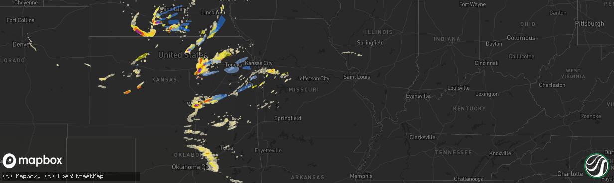
Hail Map in Missouri on April 29, 2022
The weather event in Missouri on April 29, 2022 includes Hail, Wind, and Tornado maps. 8 states and 592 cities were impacted and suffered possible damage. The total estimated number of properties impacted is 2,389.
Want more than just the map?
Turn this storm into a full workflow.
- Owner + property data so you know who to knock
- OnDemand branded weather history reports to win the "did we even have hail?" argument
- RoofTrace estimate so reps stop guessing numbers at the door
Bought this map? Upgrade within 7 days and we'll credit the $230. (10-15 min setup call)
Hail
Wind
Tornado
2,389
Estimated number of impacted properties by a 1.00" hail or larger140
Estimated number of impacted properties by a 1.75" hail or larger0
Estimated number of impacted properties by a 2.50" hail or largerStorm reports in Missouri
Missouri
| Date | Description |
|---|---|
| 04/29/202212:02 PM CDT | A local report indicates 1.00 inch wind near 1 S LA MONTE |
| 04/29/202211:43 AM CDT | A local report indicates 1.00 inch wind near 2 ENE WARRENSBURG |
| 04/29/202211:21 AM CDT | A local report indicates 1.75 inch wind near 4 ESE PITTSVILLE |
| 04/29/202210:33 AM CDT | A local report indicates 1.00 inch wind near 4 SW STRASBURG |
| 04/29/20229:54 AM CDT | A local report indicates 1.00 inch wind near 5 W ADRIAN |
| 04/29/20227:29 AM CDT | At 1228 PM CDT, a severe thunderstorm was located near Smithton, or near Sedalia, moving east at 40 mph. HAZARD...60 mph wind gusts and quarter size hail. SOURCE...Radar indicated. IMPACT...Hail damage to vehicles is expected. Expect wind damage to roofs, siding, and trees. Locations impacted include... Sedalia, Pilot Grove, Smithton, Otterville, Bunceton, Prairie Home, Sedalia Memorial Arpt and Clifton City. |
| 04/29/20226:43 AM CDT | At 1143 AM CDT, a severe thunderstorm was located over Warrensburg, moving east at 35 mph. HAZARD...60 mph wind gusts and half dollar size hail. SOURCE...Radar indicated. IMPACT...Hail damage to vehicles is expected. Expect wind damage to roofs, siding, and trees. Locations impacted include... Sedalia, Warrensburg, Knob Noster, Sweet Springs, Whiteman Air Force Base, La Monte, Green Ridge, Houstonia, Whiteman Afb and Hughesville.This includes Interstate 70 in Missouri between mile markers 70 and75. |
| 04/29/20226:08 AM CDT | At 1108 AM CDT, a severe thunderstorm was located near Oak Grove, moving east at 35 mph. HAZARD...60 mph wind gusts and half dollar size hail. SOURCE...Radar indicated. IMPACT...Hail damage to vehicles is expected. Expect wind damage to roofs, siding, and trees. Locations impacted include... Warrensburg, Higginsville, Knob Noster, Concordia, Holden, Sweet Springs, La Monte, Corder, Alma, Lake Lafayette, Centerview, Emma, Aullville, Fayetteville and Pittsville.This includes Interstate 70 in Missouri between mile markers 44 and67. |
| 04/29/20226:07 AM CDT | At 1107 PM CDT, a severe thunderstorm was located over Baldwin Park, or over Pleasant Hill, moving east at 40 mph. HAZARD...60 mph wind gusts and nickel size hail. SOURCE...Radar indicated. IMPACT...Expect damage to roofs, siding, and trees. Locations impacted include... Lee's Summit, Harrisonville, Pleasant Hill, Odessa, Greenwood, Holden, Lake Lotawana, Garden City, Lake Winnebago, Lone Jack, East Lynne, Kingsville, Baldwin Park, Lake Lafayette, Centerview, Strasburg, Gunn City, La Tour, Tarsney Lakes and Pittsville.This includes Interstate 70 in Missouri between mile markers 38 and44. |
| 04/29/20225:44 AM CDT | At 1044 PM CDT, a severe thunderstorm was located over Drexel, or 9 miles south of Louisburg, moving northeast at 40 mph. HAZARD...60 mph wind gusts and quarter size hail. SOURCE...Radar indicated. IMPACT...Hail damage to vehicles is expected. Expect wind damage to roofs, siding, and trees. Locations impacted include... Lee's Summit, Belton, Raymore, Harrisonville, Pleasant Hill, Peculiar, Louisburg, Adrian, Garden City, Pleasanton, La Cygne, Mound City, Archie, Lake Winnebago, Drexel, Linn Valley, Cleveland, Freeman, East Lynne and Blue Mound. |
| 04/29/20225:16 AM CDT | At 1016 PM CDT, a severe thunderstorm was located over Parker, or 12 miles east of Garnett, moving east at 55 mph. HAZARD...60 mph wind gusts and quarter size hail. SOURCE...Radar indicated. IMPACT...Hail damage to vehicles is expected. Expect wind damage to roofs, siding, and trees. Locations impacted include... Paola, Osawatomie, Pleasanton, La Cygne, Drexel, Linn Valley, Parker, Fontana, New Lancaster and Beagle. |
| 04/29/20225:08 AM CDT | At 1007 PM CDT, severe thunderstorms were located along a line extending from 6 miles south of Ravenwood to 7 miles east of St. Joseph to Weston, moving east at 35 mph. HAZARD...60 mph wind gusts and nickel size hail. SOURCE...Radar indicated. IMPACT...Expect damage to roofs, siding, and trees. Locations impacted include... St. Joseph, Maryville, Cameron, Savannah, Bethany, Plattsburg, Lathrop, Hamilton, Gallatin, Albany, Weston, Gower, Stanberry, Maysville, King City, Grant City, Stewartsville, Agency, Trimble and Edgerton.This includes the following highways... Interstate 35 in Missouri between mile markers 33 and 86. Interstate 29 between mile markers 24 and 53. Interstate 229 between mile markers 0 and 1. |
| 04/29/20224:58 AM CDT | At 957 PM CDT, severe thunderstorms were located along a line extending from 6 miles northeast of McLouth to near Lawrence to near Pomona, moving east at 45 mph. HAZARD...60 mph wind gusts and quarter size hail. SOURCE...Radar indicated. IMPACT...Hail damage to vehicles is expected. Expect wind damage to roofs, siding, and trees. Locations impacted include... Kansas City, Overland Park, Olathe, Independence, Lee's Summit, Shawnee, Lenexa, Leavenworth, Leawood, Raytown, Liberty, Gladstone, Grandview, Belton, Prairie Village, Raymore, Gardner, Lansing, Merriam and Mission.This includes the following highways... Interstate 70 in Missouri between mile markers 0 and 13. Interstate 70 in Kansas between mile markers 410 and 423. Interstate 35 in Missouri between mile markers 0 and 27. Interstate 35 in Kansas between mile markers 200 and 235. Interstate 29 between mile markers 0 and 23. Interstate 635 between mile markers 0 and 12. Interstate 470 between mile markers 0 and 8. Interstate 435 between mile markers 0 and 83. Kansas Turnpike between mile markers 206 and 226. |
| 04/29/20224:51 AM CDT | At 951 AM CDT, a severe thunderstorm was located near Adrian, moving east at 30 mph. HAZARD...Quarter size hail. SOURCE...Radar indicated. IMPACT...Damage to vehicles is expected. Locations impacted include... Adrian, Garden City and Ballard. |
| 04/29/20224:44 AM CDT | At 943 AM CDT, a severe thunderstorm was located near Essex, or 24 miles north of Tarkio, moving northeast at 30 mph. HAZARD...60 mph wind gusts. SOURCE...Radar indicated. IMPACT...Expect damage to roofs, siding, and trees. This severe thunderstorm will be near... Clarinda around 955 AM CDT.Other locations in the path of this severe thunderstorm includeVillisca. |
| 04/29/202212:34 AM CDT | 50 mph winds with the hail. |
| 04/29/202212:15 AM CDT | A local report indicates 63 MPH wind near MARSHALL |
| 04/29/202212:15 AM CDT | Delayed report...roof blown off of marshall municipal airport. |
| 04/28/202211:02 PM CDT | Wind gust at the office. |
| 04/28/202210:11 PM CDT | Power loss. |
| 04/28/20229:52 PM CDT | Delayed report....estimated winds of 60 mph. |
| 04/28/20229:44 PM CDT | Delayed report... A detached garage was pushed off its foundation in rushville. |
| 04/28/20229:42 PM CDT | A local report indicates 1.00 inch wind near 2 W LEWIS AND CLARK VIL |
| 04/28/20229:25 PM CDT | Delayed report...photos sent via twitter showing damage to roof of a house and shed. Also debris blown around the property. |
All States Impacted by Hail Map on April 29, 2022
Cities Impacted by Hail Map on April 29, 2022
- Elwood, NE
- Cozad, NE
- Lexington, NE
- Odessa, MO
- Wilcox, NE
- Minden, NE
- Axtell, NE
- Hildreth, NE
- Stillwater, OK
- Ripley, OK
- Agra, OK
- Cushing, OK
- Stroud, OK
- Yale, OK
- Guide Rock, NE
- Funk, NE
- Holbrook, NE
- Paola, KS
- Depew, OK
- Holden, MO
- Centerview, MO
- Kingsville, MO
- Greenwood, MO
- Bates City, MO
- Peculiar, MO
- Belton, MO
- Warrensburg, MO
- Lone Jack, MO
- Pleasant Hill, MO
- Kansas City, MO
- Raymore, MO
- Lees Summit, MO
- Shelby, NE
- Lewis, IA
- Genoa, NE
- Orleans, NE
- Arapahoe, NE
- Beaver City, NE
- Republican City, NE
- Bloomington, NE
- Alma, NE
- Eustis, NE
- Stamford, NE
- Edison, NE
- Oxford, NE
- Phillipsburg, KS
- Naponee, NE
- Cambridge, NE
- Ottawa, KS
- Princeton, KS
- Sedan, KS
- Elk City, KS
- Covington, OK
- Pleasanton, NE
- Riverdale, NE
- Gibbon, NE
- Ravenna, NE
- Kearney, NE
- Onaga, KS
- Earling, IA
- Dunlap, IA
- Murdock, NE
- Louisville, NE
- Athol, KS
- Cedar, KS
- Kensington, KS
- Gaylord, KS
- Kirwin, KS
- Lancaster, KS
- Everest, KS
- Morrison, OK
- Wichita, KS
- Glencoe, OK
- Concordia, KS
- Appleton City, MO
- Rockville, MO
- Dearing, KS
- Caney, KS
- Wann, OK
- Coffeyville, KS
- Independence, KS
- Ransom, KS
- Green Ridge, MO
- Lincoln, MO
- Cole Camp, MO
- Ionia, MO
- Edgar, NE
- Butler, MO
- Adrian, MO
- El Dorado, KS
- Le Roy, KS
- Neosho Falls, KS
- Colony, KS
- Morrowville, KS
- Washington, KS
- Haddam, KS
- Beatrice, NE
- Lamont, OK
- Eureka, KS
- Bristow, OK
- Deshler, NE
- Oak, NE
- Davenport, NE
- Blue Hill, NE
- Glenvil, NE
- Fairfield, NE
- Lawrence, NE
- Deweese, NE
- Nelson, NE
- Leoti, KS
- Derby, KS
- Campbell, NE
- Pawnee, OK
- Harlan, IA
- Walnut, IA
- Elk Horn, IA
- Kimballton, IA
- Irwin, IA
- Audubon, IA
- Hastings, NE
- Olathe, KS
- Spring Hill, KS
- Prague, OK
- Paden, OK
- Sparks, OK
- Mcconnell Afb, KS
- Hill City, KS
- Collyer, KS
- Morland, KS
- Quinter, KS
- Wakeeney, KS
- Bladen, NE
- Rosalia, KS
- Leon, KS
- Humansville, MO
- Stockton, MO
- Ruskin, NE
- Hettick, IL
- Fullerton, NE
- Pawhuska, OK
- Cimarron, KS
- Holdrege, NE
- Jansen, NE
- Rising City, NE
- Surprise, NE
- Stromsburg, NE
- Osceola, NE
- Gresham, NE
- Ulysses, NE
- White City, KS
- Okemah, OK
- Clifton, KS
- Palmer, KS
- Coweta, OK
- Broken Arrow, OK
- Clay Center, NE
- Sutton, NE
- Harrisonville, MO
- Garden City, MO
- Juniata, NE
- Kenesaw, NE
- Soldier, KS
- Holton, KS
- Abilene, KS
- Woodbine, KS
- Enterprise, KS
- Chapman, KS
- Wakefield, KS
- Junction City, KS
- Cedar Creek, NE
- Springfield, NE
- Weeping Water, NE
- Hendley, NE
- Long Island, KS
- Westmoreland, KS
- Saint George, KS
- Valley Center, KS
- Scott City, KS
- Havensville, KS
- Wamego, KS
- Casey, IA
- Fontanelle, IA
- Greenfield, IA
- Enid, OK
- Kremlin, OK
- Hunter, OK
- Defiance, IA
- Elmwood, NE
- Carleton, NE
- Ness City, KS
- Jetmore, KS
- Arcadia, KS
- Bronaugh, MO
- Liberal, MO
- Agenda, KS
- Clyde, KS
- Aurora, KS
- Belleville, KS
- McCool Junction, NE
- Fairmont, NE
- Jerico Springs, MO
- Lamar, MO
- Avoca, NE
- Anselmo, NE
- Merna, NE
- Ayr, NE
- Tecumseh, NE
- Denver, CO
- Bazine, KS
- Endicott, NE
- Commerce City, CO
- Brighton, CO
- Whitewater, KS
- Wellington, KS
- Belle Plaine, KS
- Ogallah, KS
- Utica, KS
- Augusta, KS
- Douglass, KS
- Kansas City, KS
- Garnett, KS
- Haysville, KS
- Clearwater, KS
- Andover, KS
- Rose Hill, KS
- Blue Springs, NE
- Wymore, NE
- Havana, KS
- Niotaze, KS
- Fort Riley, KS
- Hope, KS
- Gypsum, KS
- Riley, KS
- Milford, KS
- Wagoner, OK
- Atchison, KS
- Fontana, KS
- Windsor, MO
- Sedalia, MO
- Knob Noster, MO
- La Monte, MO
- Chilhowee, MO
- S Coffeyville, OK
- Linn, KS
- Columbus, NE
- Shawnee, OK
- Drumright, OK
- Chandler, OK
- Perry, OK
- Tryon, OK
- Perkins, OK
- Manley, NE
- Superior, NE
- Hardy, NE
- Byron, NE
- Republic, KS
- Wetmore, KS
- Circleville, KS
- Netawaka, KS
- Hillsboro, KS
- Valley Falls, KS
- Effingham, KS
- Muscotah, KS
- Wilburton, OK
- Peru, KS
- Salix, IA
- Manhattan, KS
- Belvue, KS
- Doniphan, NE
- Wood River, NE
- Unadilla, NE
- Palmyra, NE
- Westerville, NE
- Ansley, NE
- Hillview, IL
- White Hall, IL
- Mayfield, KS
- Lenapah, OK
- Delaware, OK
- Benton, KS
- Arapahoe, CO
- Boley, OK
- Castle, OK
- Seminole, OK
- Palco, KS
- Plainville, KS
- Bridgewater, IA
- Oakley, KS
- Tribune, KS
- Winona, KS
- Nevada, MO
- Heartwell, NE
- Brady, NE
- Watkins, CO
- Aurora, CO
- Overland Park, KS
- Stilwell, KS
- Wewoka, OK
- Douglas, OK
- Diller, NE
- Fairbury, NE
- Bucyrus, KS
- Red Rock, OK
- Atlantic, IA
- Griswold, IA
- Manilla, IA
- Hiawatha, KS
- Saint Joseph, MO
- Ponca City, OK
- Blackwell, OK
- Tonkawa, OK
- Osceola, MO
- Shelby, IA
- Peck, KS
- Sedgwick, KS
- Maize, KS
- Mulvane, KS
- Towanda, KS
- Newton, KS
- Milan, KS
- Kechi, KS
- South Haven, KS
- Caldwell, KS
- Broken Bow, NE
- Greenfield, IL
- Palmyra, IL
- Pearl, IL
- Emmett, KS
- Moline, KS
- Cedar Vale, KS
- Tampa, KS
- Copan, OK
- Welda, KS
- Earlsboro, OK
- Bennett, CO
- Callaway, NE
- Clay Center, KS
- Talmage, KS
- Longford, KS
- Herington, KS
- Roodhouse, IL
- Pomona, KS
- Richmond, KS
- Westphalia, KS
- Brownell, KS
- Comstock, NE
- Ord, NE
- Shidler, OK
- Garber, OK
- Billings, OK
- Dadeville, MO
- Aldrich, MO
- Maxwell, NE
- Saint Libory, NE
- Grand Island, NE
- Chapman, NE
- Columbus, KS
- Milo, MO
- Sheldon, MO
- Weskan, KS
- Burlington, CO
- Sargent, NE
- Burwell, NE
- Hepler, KS
- Farlington, KS
- Mound Valley, KS
- Altamont, KS
- Medford, OK
- Edna, KS
- Lakin, KS
- Pleasanton, KS
- Decatur, NE
- Tekamah, NE
- Yates Center, KS
- Parker, KS
- La Cygne, KS
- Holstein, NE
- Fort Lupton, CO
- Adams, NE
- Sterling, NE
- Lewiston, NE
- Virginia, NE
- Filley, NE
- Crab Orchard, NE
- Kingsley, IA
- Liberty, KS
- Burchard, NE
- Orlando, OK
- Cumberland, IA
- Wiota, IA
- Goodland, KS
- Boelus, NE
- Rockville, NE
- Benedict, NE
- Chetopa, KS
- Henderson, NE
- Bradshaw, NE
- Shelton, NE
- Dighton, KS
- North Fort Myers, FL
- Punta Gorda, FL
- Hugo, CO
- Dwight, KS
- Alta Vista, KS
- Gove, KS
- Neola, IA
- McClelland, IA
- Minden, IA
- Osawatomie, KS
- Wetumka, OK
- Oketo, KS
- Cairo, NE
- Lane, KS
- Rantoul, KS
- Marshall, OK
- Lucien, OK
- Solomon, KS
- Paxico, KS
- Saint Marys, KS
- Delia, KS
- Alma, KS
- Goff, KS
- Greenwich, KS
- Deer Creek, OK
- Ramona, KS
- Lost Springs, KS
- Fort Gibson, OK
- Mora, MO
- Smithton, MO
- Oak Grove, MO
- Grain Valley, MO
- Burns, KS
- Hamilton, KS
- Piedmont, KS
- Virgil, KS
- Saint Edward, NE
- York, NE
- Grafton, NE
- Fort Myers, FL
- Courtland, KS
- Odell, NE
- Mindenmines, MO
- Chautauqua, KS
- Nebo, IL
- Grandview, MO
- Greeley, KS
- Pickrell, NE
- Lebo, KS
- Guthrie, OK
- Geneva, NE
- Grenola, KS
- Elyria, NE
- El Dorado Springs, MO
- Arnold, NE
- Morganville, KS
- Piqua, KS
- Mcalester, OK
- Horton, KS
- Vail, IA
- Denison, IA
- Glasco, KS
- Williamsburg, KS
- Hartshorne, OK
- Pond Creek, OK
- Cummings, KS
- Farnam, NE
- Tyro, KS
- Dewey, OK
- Dexter, KS
- Goddard, KS
- Riverton, IA
- Hamburg, IA
- Damar, KS
- Scotia, NE
- Nehawka, NE
- Indianola, OK
- Lowry City, MO
- Herman, NE
- Arlington, NE
- Craig, NE
- North Platte, NE
- Hoxie, KS
- Palmer, NE
- Marysville, KS
- Hanover, KS
- Barneston, NE
- Bremen, KS
- Liberty, NE
- Leonardville, KS
- Carney, OK
- Meeker, OK
- Davenport, OK
- Amoret, MO
- Pleasant Hill, IL
- Maple City, KS
- Stockton, KS
- Healy, KS
- Potwin, KS
- Hancock, IA
- Avoca, IA
- Panama, IA
- Bogue, KS
- Wellston, OK
- Amsterdam, MO
- Archie, MO
- Persia, IA
- Logan, IA
- Mayetta, KS
- Mahaska, KS
- Hollenberg, KS
- Porter, OK
- Hornick, IA
- Bronson, IA
- Moville, IA
- Tulsa, OK
- Owasso, OK
- Clarkson, NE
- Mound City, KS
- Centerville, KS
- Woodbine, IA
- Portsmouth, IA
- Sloan, IA
- Sergeant Bluff, IA
- Strasburg, CO
- Geuda Springs, KS
- Red Oak, OK
- Ingalls, KS
- Alda, NE
- Phillips, NE
- Marquette, NE
- Harvard, NE
- Inland, NE
- Roseland, NE
- Trumbull, NE
- Giltner, NE
- Hebron, NE
- Red Cloud, NE
- Shickley, NE
- Ong, NE
- Strang, NE
- Syracuse, NE
- Murray, NE
- Union, NE
- Cook, NE
- Brock, NE
- Lorton, NE
- Dunbar, NE
- Plattsmouth, NE
- Otoe, NE
- Steinauer, NE
- Talmage, NE
- Burr, NE
- Nebraska City, NE
- Schuyler, NE
- Silver Creek, NE
- Dodge, NE
- Linwood, NE
- Rogers, NE
- North Bend, NE
- David City, NE
- Bellwood, NE
- Ogden, KS
- Council Grove, KS
- Harveyville, KS
- Berryton, KS
- Burlingame, KS
- Scranton, KS
- Lecompton, KS
- Eskridge, KS
- Tecumseh, KS
- Wakarusa, KS
- Auburn, KS
- Topeka, KS
- Carbondale, KS
- Overbrook, KS
- Easton, KS
- Leavenworth, KS
- Tonganoxie, KS
- Oskaloosa, KS
- Grantville, KS
- Ozawkie, KS
- Meriden, KS
- McLouth, KS
- Perry, KS
- Bonner Springs, KS
- De Soto, KS
- Lawrence, KS
- Eudora, KS
- Linwood, KS
- Louisburg, KS
- Cleveland, MO
- Hughesville, MO


