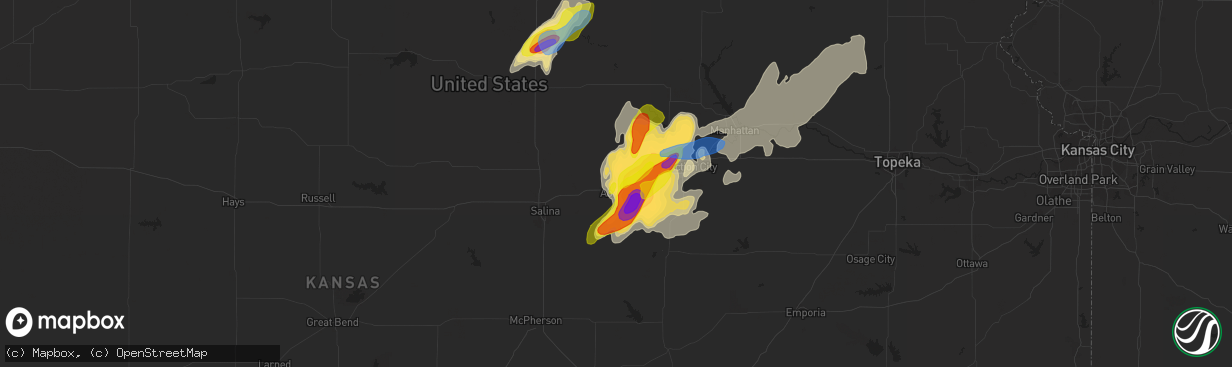
Hail Map in Abilene, KS on April 29, 2022
The weather event in Abilene, KS on April 29, 2022 includes Hail, Wind, and Tornado maps. 8 states and 592 cities were impacted and suffered possible damage. The total estimated number of properties impacted is 3,268.
Hail
Wind
Tornado
3,268
Estimated number of impacted properties by a 1.00" hail or larger996
Estimated number of impacted properties by a 1.75" hail or larger215
Estimated number of impacted properties by a 2.50" hail or largerStorm reports in Abilene, KS
Abilene, KS
| Date | Description |
|---|---|
| 04/29/20226:59 PM CDT | A local report indicates 1.75 inch wind near ABILENE |
| 04/29/20226:53 PM CDT | A local report indicates 1.75 inch wind near 3 NE ABILENE |
| 04/29/20226:51 PM CDT | A local report indicates 1.00 inch wind near ABILENE |
| 04/29/20226:48 PM CDT | A local report indicates 1.75 inch wind near ABILENE |
| 04/29/20226:31 PM CDT | Spotter reported tornado north of carlton. |
| 04/29/20226:29 PM CDT | Also reports a funnel cloud. |
| 04/29/20226:23 PM CDT | A local report indicates 1.50 inch wind near 8 NNW MOONLIGHT |
| 04/29/20226:13 PM CDT | A local report indicates 1.75 inch wind near 5 NW MOONLIGHT |
| 04/29/20225:51 PM CDT | Spotter reports quarter to half-dollar sized hail just on the western side of abilene city limits. |
| 04/28/20227:20 PM CDT | Delayed report. |
| 04/28/20227:17 PM CDT | A local report indicates 2.75 inch wind near 4 NNE ENTERPRISE |
| 04/28/20227:00 PM CDT | Delayed report from facebook. |
All States Impacted by Hail Map on April 29, 2022
All Cities Impacted by Hail Map on April 29, 2022
- Elwood, NE
- Cozad, NE
- Lexington, NE
- Odessa, MO
- Wilcox, NE
- Minden, NE
- Axtell, NE
- Hildreth, NE
- Stillwater, OK
- Ripley, OK
- Agra, OK
- Cushing, OK
- Stroud, OK
- Yale, OK
- Guide Rock, NE
- Funk, NE
- Holbrook, NE
- Paola, KS
- Depew, OK
- Holden, MO
- Centerview, MO
- Kingsville, MO
- Greenwood, MO
- Bates City, MO
- Peculiar, MO
- Belton, MO
- Warrensburg, MO
- Lone Jack, MO
- Pleasant Hill, MO
- Kansas City, MO
- Raymore, MO
- Lees Summit, MO
- Shelby, NE
- Lewis, IA
- Genoa, NE
- Orleans, NE
- Arapahoe, NE
- Beaver City, NE
- Republican City, NE
- Bloomington, NE
- Alma, NE
- Eustis, NE
- Stamford, NE
- Edison, NE
- Oxford, NE
- Phillipsburg, KS
- Naponee, NE
- Cambridge, NE
- Ottawa, KS
- Princeton, KS
- Sedan, KS
- Elk City, KS
- Covington, OK
- Pleasanton, NE
- Riverdale, NE
- Gibbon, NE
- Ravenna, NE
- Kearney, NE
- Onaga, KS
- Earling, IA
- Dunlap, IA
- Murdock, NE
- Louisville, NE
- Athol, KS
- Cedar, KS
- Kensington, KS
- Gaylord, KS
- Kirwin, KS
- Lancaster, KS
- Everest, KS
- Morrison, OK
- Wichita, KS
- Glencoe, OK
- Concordia, KS
- Appleton City, MO
- Rockville, MO
- Dearing, KS
- Caney, KS
- Wann, OK
- Coffeyville, KS
- Independence, KS
- Ransom, KS
- Green Ridge, MO
- Lincoln, MO
- Cole Camp, MO
- Ionia, MO
- Edgar, NE
- Butler, MO
- Adrian, MO
- El Dorado, KS
- Le Roy, KS
- Neosho Falls, KS
- Colony, KS
- Morrowville, KS
- Washington, KS
- Haddam, KS
- Beatrice, NE
- Lamont, OK
- Eureka, KS
- Bristow, OK
- Deshler, NE
- Oak, NE
- Davenport, NE
- Blue Hill, NE
- Glenvil, NE
- Fairfield, NE
- Lawrence, NE
- Deweese, NE
- Nelson, NE
- Leoti, KS
- Derby, KS
- Campbell, NE
- Pawnee, OK
- Harlan, IA
- Walnut, IA
- Elk Horn, IA
- Kimballton, IA
- Irwin, IA
- Audubon, IA
- Hastings, NE
- Olathe, KS
- Spring Hill, KS
- Prague, OK
- Paden, OK
- Sparks, OK
- Mcconnell Afb, KS
- Hill City, KS
- Collyer, KS
- Morland, KS
- Quinter, KS
- Wakeeney, KS
- Bladen, NE
- Rosalia, KS
- Leon, KS
- Humansville, MO
- Stockton, MO
- Ruskin, NE
- Hettick, IL
- Fullerton, NE
- Pawhuska, OK
- Cimarron, KS
- Holdrege, NE
- Jansen, NE
- Rising City, NE
- Surprise, NE
- Stromsburg, NE
- Osceola, NE
- Gresham, NE
- Ulysses, NE
- White City, KS
- Okemah, OK
- Clifton, KS
- Palmer, KS
- Coweta, OK
- Broken Arrow, OK
- Clay Center, NE
- Sutton, NE
- Harrisonville, MO
- Garden City, MO
- Juniata, NE
- Kenesaw, NE
- Soldier, KS
- Holton, KS
- Abilene, KS
- Woodbine, KS
- Enterprise, KS
- Chapman, KS
- Wakefield, KS
- Junction City, KS
- Cedar Creek, NE
- Springfield, NE
- Weeping Water, NE
- Hendley, NE
- Long Island, KS
- Westmoreland, KS
- Saint George, KS
- Valley Center, KS
- Scott City, KS
- Havensville, KS
- Wamego, KS
- Casey, IA
- Fontanelle, IA
- Greenfield, IA
- Enid, OK
- Kremlin, OK
- Hunter, OK
- Defiance, IA
- Elmwood, NE
- Carleton, NE
- Ness City, KS
- Jetmore, KS
- Arcadia, KS
- Bronaugh, MO
- Liberal, MO
- Agenda, KS
- Clyde, KS
- Aurora, KS
- Belleville, KS
- McCool Junction, NE
- Fairmont, NE
- Jerico Springs, MO
- Lamar, MO
- Avoca, NE
- Anselmo, NE
- Merna, NE
- Ayr, NE
- Tecumseh, NE
- Denver, CO
- Bazine, KS
- Endicott, NE
- Commerce City, CO
- Brighton, CO
- Whitewater, KS
- Wellington, KS
- Belle Plaine, KS
- Ogallah, KS
- Utica, KS
- Augusta, KS
- Douglass, KS
- Kansas City, KS
- Garnett, KS
- Haysville, KS
- Clearwater, KS
- Andover, KS
- Rose Hill, KS
- Blue Springs, NE
- Wymore, NE
- Havana, KS
- Niotaze, KS
- Fort Riley, KS
- Hope, KS
- Gypsum, KS
- Riley, KS
- Milford, KS
- Wagoner, OK
- Atchison, KS
- Fontana, KS
- Windsor, MO
- Sedalia, MO
- Knob Noster, MO
- La Monte, MO
- Chilhowee, MO
- S Coffeyville, OK
- Linn, KS
- Columbus, NE
- Shawnee, OK
- Drumright, OK
- Chandler, OK
- Perry, OK
- Tryon, OK
- Perkins, OK
- Manley, NE
- Superior, NE
- Hardy, NE
- Byron, NE
- Republic, KS
- Wetmore, KS
- Circleville, KS
- Netawaka, KS
- Hillsboro, KS
- Valley Falls, KS
- Effingham, KS
- Muscotah, KS
- Wilburton, OK
- Peru, KS
- Salix, IA
- Manhattan, KS
- Belvue, KS
- Doniphan, NE
- Wood River, NE
- Unadilla, NE
- Palmyra, NE
- Westerville, NE
- Ansley, NE
- Hillview, IL
- White Hall, IL
- Mayfield, KS
- Lenapah, OK
- Delaware, OK
- Benton, KS
- Arapahoe, CO
- Boley, OK
- Castle, OK
- Seminole, OK
- Palco, KS
- Plainville, KS
- Bridgewater, IA
- Oakley, KS
- Tribune, KS
- Winona, KS
- Nevada, MO
- Heartwell, NE
- Brady, NE
- Watkins, CO
- Aurora, CO
- Overland Park, KS
- Stilwell, KS
- Wewoka, OK
- Douglas, OK
- Diller, NE
- Fairbury, NE
- Bucyrus, KS
- Red Rock, OK
- Atlantic, IA
- Griswold, IA
- Manilla, IA
- Hiawatha, KS
- Saint Joseph, MO
- Ponca City, OK
- Blackwell, OK
- Tonkawa, OK
- Osceola, MO
- Shelby, IA
- Peck, KS
- Sedgwick, KS
- Maize, KS
- Mulvane, KS
- Towanda, KS
- Newton, KS
- Milan, KS
- Kechi, KS
- South Haven, KS
- Caldwell, KS
- Broken Bow, NE
- Greenfield, IL
- Palmyra, IL
- Pearl, IL
- Emmett, KS
- Moline, KS
- Cedar Vale, KS
- Tampa, KS
- Copan, OK
- Welda, KS
- Earlsboro, OK
- Bennett, CO
- Callaway, NE
- Clay Center, KS
- Talmage, KS
- Longford, KS
- Herington, KS
- Roodhouse, IL
- Pomona, KS
- Richmond, KS
- Westphalia, KS
- Brownell, KS
- Comstock, NE
- Ord, NE
- Shidler, OK
- Garber, OK
- Billings, OK
- Dadeville, MO
- Aldrich, MO
- Maxwell, NE
- Saint Libory, NE
- Grand Island, NE
- Chapman, NE
- Columbus, KS
- Milo, MO
- Sheldon, MO
- Weskan, KS
- Burlington, CO
- Sargent, NE
- Burwell, NE
- Hepler, KS
- Farlington, KS
- Mound Valley, KS
- Altamont, KS
- Medford, OK
- Edna, KS
- Lakin, KS
- Pleasanton, KS
- Decatur, NE
- Tekamah, NE
- Yates Center, KS
- Parker, KS
- La Cygne, KS
- Holstein, NE
- Fort Lupton, CO
- Adams, NE
- Sterling, NE
- Lewiston, NE
- Virginia, NE
- Filley, NE
- Crab Orchard, NE
- Kingsley, IA
- Liberty, KS
- Burchard, NE
- Orlando, OK
- Cumberland, IA
- Wiota, IA
- Goodland, KS
- Boelus, NE
- Rockville, NE
- Benedict, NE
- Chetopa, KS
- Henderson, NE
- Bradshaw, NE
- Shelton, NE
- Dighton, KS
- North Fort Myers, FL
- Punta Gorda, FL
- Hugo, CO
- Dwight, KS
- Alta Vista, KS
- Gove, KS
- Neola, IA
- McClelland, IA
- Minden, IA
- Osawatomie, KS
- Wetumka, OK
- Oketo, KS
- Cairo, NE
- Lane, KS
- Rantoul, KS
- Marshall, OK
- Lucien, OK
- Solomon, KS
- Paxico, KS
- Saint Marys, KS
- Delia, KS
- Alma, KS
- Goff, KS
- Greenwich, KS
- Deer Creek, OK
- Ramona, KS
- Lost Springs, KS
- Fort Gibson, OK
- Mora, MO
- Smithton, MO
- Oak Grove, MO
- Grain Valley, MO
- Burns, KS
- Hamilton, KS
- Piedmont, KS
- Virgil, KS
- Saint Edward, NE
- York, NE
- Grafton, NE
- Fort Myers, FL
- Courtland, KS
- Odell, NE
- Mindenmines, MO
- Chautauqua, KS
- Nebo, IL
- Grandview, MO
- Greeley, KS
- Pickrell, NE
- Lebo, KS
- Guthrie, OK
- Geneva, NE
- Grenola, KS
- Elyria, NE
- El Dorado Springs, MO
- Arnold, NE
- Morganville, KS
- Piqua, KS
- Mcalester, OK
- Horton, KS
- Vail, IA
- Denison, IA
- Glasco, KS
- Williamsburg, KS
- Hartshorne, OK
- Pond Creek, OK
- Cummings, KS
- Farnam, NE
- Tyro, KS
- Dewey, OK
- Dexter, KS
- Goddard, KS
- Riverton, IA
- Hamburg, IA
- Damar, KS
- Scotia, NE
- Nehawka, NE
- Indianola, OK
- Lowry City, MO
- Herman, NE
- Arlington, NE
- Craig, NE
- North Platte, NE
- Hoxie, KS
- Palmer, NE
- Marysville, KS
- Hanover, KS
- Barneston, NE
- Bremen, KS
- Liberty, NE
- Leonardville, KS
- Carney, OK
- Meeker, OK
- Davenport, OK
- Amoret, MO
- Pleasant Hill, IL
- Maple City, KS
- Stockton, KS
- Healy, KS
- Potwin, KS
- Hancock, IA
- Avoca, IA
- Panama, IA
- Bogue, KS
- Wellston, OK
- Amsterdam, MO
- Archie, MO
- Persia, IA
- Logan, IA
- Mayetta, KS
- Mahaska, KS
- Hollenberg, KS
- Porter, OK
- Hornick, IA
- Bronson, IA
- Moville, IA
- Tulsa, OK
- Owasso, OK
- Clarkson, NE
- Mound City, KS
- Centerville, KS
- Woodbine, IA
- Portsmouth, IA
- Sloan, IA
- Sergeant Bluff, IA
- Strasburg, CO
- Geuda Springs, KS
- Red Oak, OK
- Ingalls, KS
- Alda, NE
- Phillips, NE
- Marquette, NE
- Harvard, NE
- Inland, NE
- Roseland, NE
- Trumbull, NE
- Giltner, NE
- Hebron, NE
- Red Cloud, NE
- Shickley, NE
- Ong, NE
- Strang, NE
- Syracuse, NE
- Murray, NE
- Union, NE
- Cook, NE
- Brock, NE
- Lorton, NE
- Dunbar, NE
- Plattsmouth, NE
- Otoe, NE
- Steinauer, NE
- Talmage, NE
- Burr, NE
- Nebraska City, NE
- Schuyler, NE
- Silver Creek, NE
- Dodge, NE
- Linwood, NE
- Rogers, NE
- North Bend, NE
- David City, NE
- Bellwood, NE
- Ogden, KS
- Council Grove, KS
- Harveyville, KS
- Berryton, KS
- Burlingame, KS
- Scranton, KS
- Lecompton, KS
- Eskridge, KS
- Tecumseh, KS
- Wakarusa, KS
- Auburn, KS
- Topeka, KS
- Carbondale, KS
- Overbrook, KS
- Easton, KS
- Leavenworth, KS
- Tonganoxie, KS
- Oskaloosa, KS
- Grantville, KS
- Ozawkie, KS
- Meriden, KS
- McLouth, KS
- Perry, KS
- Bonner Springs, KS
- De Soto, KS
- Lawrence, KS
- Eudora, KS
- Linwood, KS
- Louisburg, KS
- Cleveland, MO
- Hughesville, MO


