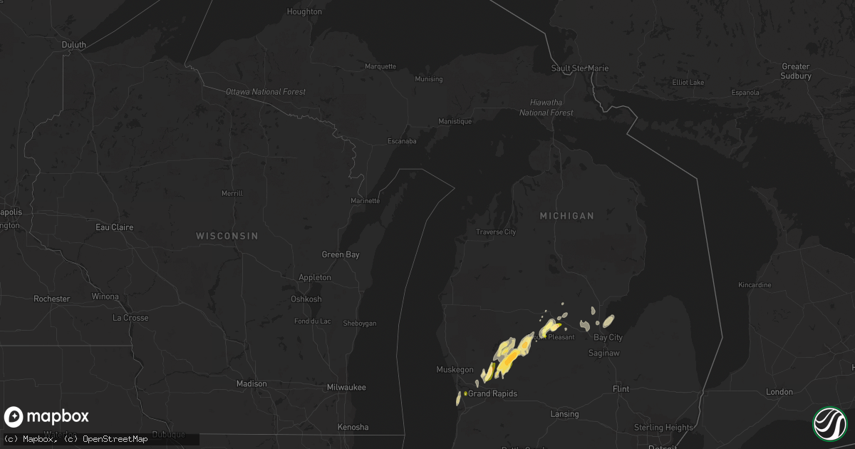
Hail Map in Michigan on April 29, 2014
Get this storm
April 29 map
$229
one time, instant access
Download today. No call, no setup
Keep the $229
Bought the map and want the full workflow? Apply the entire $229 to a subscription within 7 days. None of it is wasted.
Every map, not just this one
This buys you this map. Subscription and you get every map we run, in the markets you choose from a few cities to whole states to nationwide. Plus real-time alerts the moment a storm fires.
Contact data
Name, contact info, occupancy, even credit band for addresses in the footprint. You go from where it hit to who to call.
Become the source they trust
Unlimited branding weather history reports on demand. You already have the documented answer ready for the property owner, and you are the one who showed up with it.
Property data and RoofTrace estimates
Pull up any address you have got, its value and the exact code rules for that jurisdiction, straight from One Click Code. Then RoofTrace estimates the squares, pitch, and roof value, priced the way you price.
Storm reports in Michigan
Michigan
| Date | Description |
|---|---|
| 04/29/20145:49 PM CDT | Two trees uprooted at magrudder and isabella/m-20 |
| 04/29/20145:48 PM CDT | Trailer flipped on side off of south magrudder rd. |
| 04/29/20145:20 PM CDT | Hail duration 13 minutes |
| 04/29/20144:58 PM CDT | A local report indicates 1.00 inch wind near BLANCHARD |
| 04/29/20144:56 PM CDT | Hail the size of a half dollar fell for 11 minutes. |
| 04/29/20144:50 PM CDT | A local report indicates 1.25 inch wind near 3 SE BLANCHARD |
| 04/29/20144:42 PM CDT | A local report indicates 1.00 inch wind near 2 WSW MECOSTA |
| 04/29/20144:42 PM CDT | A local report indicates 1.00 inch wind near SIX LAKES |
| 04/29/20144:40 PM CDT | Photo sent to fox 17 from public. Courtesy of fox 17 live blog. Time is estimated by radar |
| 04/29/20144:40 PM CDT | Picture sent in to local broadcast media. Courtesy of fox 17. Time estimated by radar. |
| 04/29/20144:35 PM CDT | Hail photo sent to local broadcast media blog. Courtesy of fox 17 |
| 04/29/20144:28 PM CDT | A local report indicates 1.50 inch wind near 3 NNE LANGSTON |
| 04/29/20144:18 PM CDT | Ham radio operator forwarded photos of a snapped tree that had a diameter of 6 inches. Tree damage was isolated amongst several other smaller branches. Time estimated b |
| 04/29/20143:55 PM CDT | Received photos from the public. Time estimated by radar. |
| 04/29/20143:49 PM CDT | Relayed report from the south end of sparta |
| 04/29/20141:50 PM CDT | Traveler southbound us31 between m45 and stanton reports up to quarter-size hail. Time estimated from radar. |
| 04/28/20149:34 PM CDT | Trees downed at colwood and east cass city roads |
| 04/28/20149:26 PM CDT | Trees down at gun club road and weeden road |
| 04/28/20149:06 PM CDT | Large tree downed and blocking haines road west of grosbeck |
| 04/28/20148:35 PM CDT | A local report indicates 58 MPH wind near 4 E FENTON |
| 04/28/20148:23 PM CDT | Wires downed on mobile home causing it to catch fire |
| 04/28/20148:21 PM CDT | Tree reported down on a car at davista and orchard near duck lake |
| 04/28/20148:08 PM CDT | Powerlines reported downed at nine mile and beck roads. Also dime sized hail reported |
| 04/28/20148:05 PM CDT | Tree blown down at 8 mile and griswold roads |
| 04/28/20148:00 PM CDT | 2 foot tree limbs down at mast rd and n territorial rd. |
| 04/28/20148:00 PM CDT | 3 foot tree limb fell on 2 cars at the dexter dental office. |
All States Impacted by Hail Map on April 29, 2014
Cities Impacted by Hail Map on April 29, 2014
- Millbrook, AL
- Prattville, AL
- Wetumpka, AL
- Lowndesboro, AL
- Coosada, AL
- Montgomery, AL
- Fredericktown, OH
- Mansfield, OH
- Lucas, OH
- Bellville, OH
- Wilson, NC
- Remus, MI
- Six Lakes, MI
- Lakeview, MI
- Blanchard, MI
- Camden, AL
- Bidwell, OH
- Gallipolis, OH
- Monticello, MS
- Prentiss, MS
- Sontag, MS
- Silver Creek, MS
- Trufant, MI
- Coral, MI
- Howard City, MI
- Cedar Springs, MI
- Pierson, MI
- Sand Lake, MI
- East Palatka, FL
- Palatka, FL
- Hayneville, AL
- Eclectic, AL
- Kenly, NC
- Kent City, MI
- Sparta, MI
- Live Oak, FL
- White Springs, FL
- Roseboro, NC
- Autryville, NC
- Salemburg, NC
- Lena, MS
- Walnut Grove, MS
- Carthage, MS
- Philadelphia, MS
- Scotland Neck, NC
- Farmville, NC
- Fountain, NC
- Amite, LA
- Roseland, LA
- Black Creek, NC
- Lucama, NC
- Elm City, NC
- Jacksonville, FL
- Bogue Chitto, MS
- Brookhaven, MS
- Aberdeen, MS
- Coleman, MI
- Mendon, OH
- Rockford, OH
- Florala, AL
- Sanderson, FL
- Louisa, KY
- Ulysses, KY
- River, KY
- Polk City, FL
- Clermont, FL
- Groveland, FL
- Cheshire, OH
- Dudley, NC
- Beatrice, AL
- Franklin, AL
- Pine Apple, AL
- Vredenburgh, AL
- Dillon, SC
- Hamer, SC
- Walstonburg, NC
- Greenville, NC
- Hookerton, NC
- Okolona, MS
- Beaumont, MS
- New Augusta, MS
- Tutor Key, KY
- Lowmansville, KY
- Paintsville, KY
- Tomahawk, KY
- Logan, AL
- Cullman, AL
- Crane Hill, AL
- Conklin, MI
- Casnovia, MI
- Lake City, FL
- Macclesfield, NC
- Stantonsburg, NC
- Fremont, NC
- Middleport, OH
- Vinton, OH
- Coden, AL
- Cove City, NC
- Trenton, NC
- Mount Pleasant, MI
- Clare, MI
- Rosebush, MI
- Sims, NC
- Grant, MI
- Thurman, OH
- Long Bottom, OH
- Pomeroy, OH
- Rio Grande, OH
- Patriot, OH
- Oak Hill, OH
- Farwell, MI
- Lake, MI
- Parkton, NC
- Wade, NC
- Hope Mills, NC
- Fayetteville, NC
- Butler, OH
- Spring Hope, NC
- Bailey, NC
- Ocala, FL
- Lake Panasoffkee, FL
- Sandgap, KY
- McKee, KY
- Saucier, MS
- Vancleave, MS
- Raeford, NC
- Kingsland, GA
- Pinconning, MI
- Rhodes, MI
- Bentley, MI
- Halifax, NC
- Enfield, NC
- Amory, MS
- Smithville, MS
- Rockford, MI
- Newaygo, MI
- Comstock Park, MI
- Morley, MI
- Mecosta, MI
- Edmore, MI
- Weidman, MI
- Stanwood, MI
- Red Springs, NC
- Pinetops, NC
- Saint Marys, GA
- Yulee, FL
- Richmond, IN
- Snow Hill, NC
- La Grange, NC
- Reddick, FL
- Williston, FL
- Micanopy, FL
- Tyler, AL
- Kentwood, LA
- Greensburg, LA
- Lake Wales, FL
- Smithfield, NC
- Clayton, NC
- Kissimmee, FL
- Plant City, FL
- Valrico, FL
- Riverview, FL
- Dover, FL
- Lithia, FL
- Frostproof, FL
- Stedman, NC
- Holland, MI
- West Olive, MI
- Mount Vernon, KY
- Linwood, MI
- Tuscumbia, AL
- Wiggins, MS
- Perkinston, MS
- Zellwood, FL
- Apopka, FL
- Hawthorne, FL
- Albany, OH
- Rutland, OH
- Langsville, OH
- Fernandina Beach, FL
- Rich Square, NC
- Perry, FL
- Coopersville, MI
- Satsuma, FL
- San Mateo, FL
- Hastings, FL
- Bunnell, FL
- Interlachen, FL
- Slaughter, LA
- Zachary, LA
- Pikeville, NC
- Thelma, KY
- Moultrie, GA
- Doerun, GA
- Beaverton, MI
- Dunn, NC
- Inez, KY
- Williamsport, KY
- Rowland, NC
- Pembroke, NC
- Lumberton, NC
- Hagerhill, KY
- Glen Saint Mary, FL
- Macclenny, FL
- Rocky Mount, NC
- Grand Bay, AL
- Bayou La Batre, AL
- Dade City, FL
- Hilliard, FL
- Callahan, FL
- Lucedale, MS
- Somerset, KY
- Princeton, NC
- Clinton, NC
- Pass Christian, MS
- Bay Saint Louis, MS
- Waveland, MS
- Tallahassee, FL
- Monticello, FL
- Starke, FL
- Lawtey, FL
- Lake Butler, FL
- Oviedo, FL
- New Brockton, AL
- Brooksville, FL
- Windermere, FL
- Winter Garden, FL
- Poplarville, MS
- Grand Haven, MI
- Pine Top, KY
- Mallie, KY
- Crescent City, FL
- Cherokee, AL
- Florence, AL
- Zebulon, NC
- Louisburg, NC
- Grifton, NC
- Indian Lake Estates, FL
- Coldwater, OH
- Celina, OH
- Fort Recovery, OH
- Diberville, MS
- Biloxi, MS
- Vanceboro, NC
- Elba, AL
- Reedsville, OH
- Mason, WV
- Racine, OH
- Fairmont, NC
- Theodore, AL
- Mobile, AL
- New Smyrna Beach, FL
- Linden, NC
- Fort Bragg, NC
- Lumber Bridge, NC
- Godwin, NC
- Galion, OH
- Melrose, FL
- Gladwin, MI
- Tarboro, NC
- Georgetown, FL
- Kawkawlin, MI
- Mount Olive, NC
- Goldsboro, NC
- Kinston, NC
- Seven Springs, NC
- McHenry, MS
- Pine Hill, AL
- Minter, AL
- Coy, AL
- Pomona Park, FL
- Lillington, NC
- Bunnlevel, NC
- Erwin, NC
- Morrison, TN
- Newton Grove, NC
- Benson, NC
- Gulfport, MS
- Sunbury, OH
- Thomaston, AL
- Catherine, AL
- Greenwell Springs, LA
- Four Oaks, NC
- Collins, MS
- Smithdale, MS
- Coolville, OH
- Mount Vernon, OH
- Ashland, OH
- Shiloh, OH
- Flatgap, KY
- Marne, MI
- Grand Rapids, MI
- Saint George, GA
- Seville, FL
- Pierson, FL
- Midland, MI
- Hope, MI
- Selma, NC
- Middlesex, NC
- Florahome, FL
- Saraland, AL
- Dover, NC
- Orlando, KY
- Livingston, KY
- West Columbia, WV


