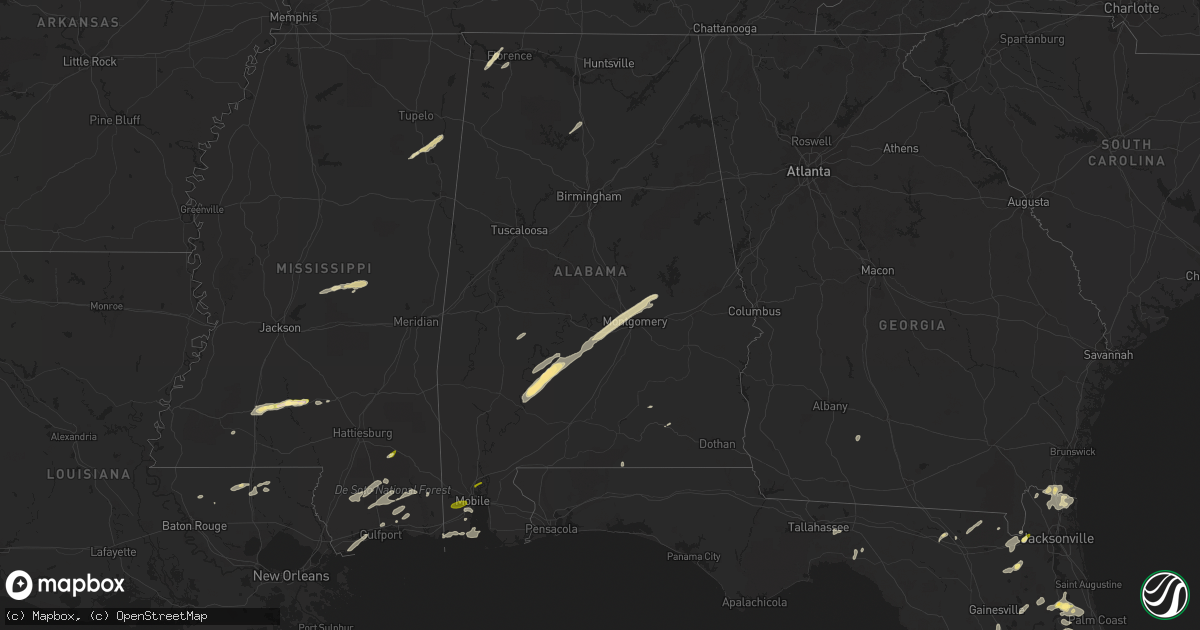
Hail Map in Alabama on April 29, 2014
Get this storm
April 29 map
$229
one time, instant access
Download today. No call, no setup
Keep the $229
Bought the map and want the full workflow? Apply the entire $229 to a subscription within 7 days. None of it is wasted.
Every map, not just this one
This buys you this map. Subscription and you get every map we run, in the markets you choose from a few cities to whole states to nationwide. Plus real-time alerts the moment a storm fires.
Contact data
Name, contact info, occupancy, even credit band for addresses in the footprint. You go from where it hit to who to call.
Become the source they trust
Unlimited branding weather history reports on demand. You already have the documented answer ready for the property owner, and you are the one who showed up with it.
Property data and RoofTrace estimates
Pull up any address you have got, its value and the exact code rules for that jurisdiction, straight from One Click Code. Then RoofTrace estimates the squares, pitch, and roof value, priced the way you price.
Storm reports in Alabama
Alabama
| Date | Description |
|---|---|
| 04/29/20146:35 PM CDT | Trees were knocked down and damage to outbuildings in the area at browns ferry road at gray road. |
| 04/29/20146:35 PM CDT | Multiple trees were knocked down on brownsferry road at near the four way stop at mooresville road. |
| 04/29/20143:50 AM CDT | Quarter size hail in cotton lakes subdivision. |
| 04/29/20143:40 AM CDT | Quarter size hail. |
| 04/28/20149:09 PM CDT | Quarter sized hail at the oakland fire department. |
All States Impacted by Hail Map on April 29, 2014
Cities Impacted by Hail Map on April 29, 2014
- Millbrook, AL
- Prattville, AL
- Wetumpka, AL
- Lowndesboro, AL
- Coosada, AL
- Montgomery, AL
- Fredericktown, OH
- Mansfield, OH
- Lucas, OH
- Bellville, OH
- Wilson, NC
- Remus, MI
- Six Lakes, MI
- Lakeview, MI
- Blanchard, MI
- Camden, AL
- Bidwell, OH
- Gallipolis, OH
- Monticello, MS
- Prentiss, MS
- Sontag, MS
- Silver Creek, MS
- Trufant, MI
- Coral, MI
- Howard City, MI
- Cedar Springs, MI
- Pierson, MI
- Sand Lake, MI
- East Palatka, FL
- Palatka, FL
- Hayneville, AL
- Eclectic, AL
- Kenly, NC
- Kent City, MI
- Sparta, MI
- Live Oak, FL
- White Springs, FL
- Roseboro, NC
- Autryville, NC
- Salemburg, NC
- Lena, MS
- Walnut Grove, MS
- Carthage, MS
- Philadelphia, MS
- Scotland Neck, NC
- Farmville, NC
- Fountain, NC
- Amite, LA
- Roseland, LA
- Black Creek, NC
- Lucama, NC
- Elm City, NC
- Jacksonville, FL
- Bogue Chitto, MS
- Brookhaven, MS
- Aberdeen, MS
- Coleman, MI
- Mendon, OH
- Rockford, OH
- Florala, AL
- Sanderson, FL
- Louisa, KY
- Ulysses, KY
- River, KY
- Polk City, FL
- Clermont, FL
- Groveland, FL
- Cheshire, OH
- Dudley, NC
- Beatrice, AL
- Franklin, AL
- Pine Apple, AL
- Vredenburgh, AL
- Dillon, SC
- Hamer, SC
- Walstonburg, NC
- Greenville, NC
- Hookerton, NC
- Okolona, MS
- Beaumont, MS
- New Augusta, MS
- Tutor Key, KY
- Lowmansville, KY
- Paintsville, KY
- Tomahawk, KY
- Logan, AL
- Cullman, AL
- Crane Hill, AL
- Conklin, MI
- Casnovia, MI
- Lake City, FL
- Macclesfield, NC
- Stantonsburg, NC
- Fremont, NC
- Middleport, OH
- Vinton, OH
- Coden, AL
- Cove City, NC
- Trenton, NC
- Mount Pleasant, MI
- Clare, MI
- Rosebush, MI
- Sims, NC
- Grant, MI
- Thurman, OH
- Long Bottom, OH
- Pomeroy, OH
- Rio Grande, OH
- Patriot, OH
- Oak Hill, OH
- Farwell, MI
- Lake, MI
- Parkton, NC
- Wade, NC
- Hope Mills, NC
- Fayetteville, NC
- Butler, OH
- Spring Hope, NC
- Bailey, NC
- Ocala, FL
- Lake Panasoffkee, FL
- Sandgap, KY
- McKee, KY
- Saucier, MS
- Vancleave, MS
- Raeford, NC
- Kingsland, GA
- Pinconning, MI
- Rhodes, MI
- Bentley, MI
- Halifax, NC
- Enfield, NC
- Amory, MS
- Smithville, MS
- Rockford, MI
- Newaygo, MI
- Comstock Park, MI
- Morley, MI
- Mecosta, MI
- Edmore, MI
- Weidman, MI
- Stanwood, MI
- Red Springs, NC
- Pinetops, NC
- Saint Marys, GA
- Yulee, FL
- Richmond, IN
- Snow Hill, NC
- La Grange, NC
- Reddick, FL
- Williston, FL
- Micanopy, FL
- Tyler, AL
- Kentwood, LA
- Greensburg, LA
- Lake Wales, FL
- Smithfield, NC
- Clayton, NC
- Kissimmee, FL
- Plant City, FL
- Valrico, FL
- Riverview, FL
- Dover, FL
- Lithia, FL
- Frostproof, FL
- Stedman, NC
- Holland, MI
- West Olive, MI
- Mount Vernon, KY
- Linwood, MI
- Tuscumbia, AL
- Wiggins, MS
- Perkinston, MS
- Zellwood, FL
- Apopka, FL
- Hawthorne, FL
- Albany, OH
- Rutland, OH
- Langsville, OH
- Fernandina Beach, FL
- Rich Square, NC
- Perry, FL
- Coopersville, MI
- Satsuma, FL
- San Mateo, FL
- Hastings, FL
- Bunnell, FL
- Interlachen, FL
- Slaughter, LA
- Zachary, LA
- Pikeville, NC
- Thelma, KY
- Moultrie, GA
- Doerun, GA
- Beaverton, MI
- Dunn, NC
- Inez, KY
- Williamsport, KY
- Rowland, NC
- Pembroke, NC
- Lumberton, NC
- Hagerhill, KY
- Glen Saint Mary, FL
- Macclenny, FL
- Rocky Mount, NC
- Grand Bay, AL
- Bayou La Batre, AL
- Dade City, FL
- Hilliard, FL
- Callahan, FL
- Lucedale, MS
- Somerset, KY
- Princeton, NC
- Clinton, NC
- Pass Christian, MS
- Bay Saint Louis, MS
- Waveland, MS
- Tallahassee, FL
- Monticello, FL
- Starke, FL
- Lawtey, FL
- Lake Butler, FL
- Oviedo, FL
- New Brockton, AL
- Brooksville, FL
- Windermere, FL
- Winter Garden, FL
- Poplarville, MS
- Grand Haven, MI
- Pine Top, KY
- Mallie, KY
- Crescent City, FL
- Cherokee, AL
- Florence, AL
- Zebulon, NC
- Louisburg, NC
- Grifton, NC
- Indian Lake Estates, FL
- Coldwater, OH
- Celina, OH
- Fort Recovery, OH
- Diberville, MS
- Biloxi, MS
- Vanceboro, NC
- Elba, AL
- Reedsville, OH
- Mason, WV
- Racine, OH
- Fairmont, NC
- Theodore, AL
- Mobile, AL
- New Smyrna Beach, FL
- Linden, NC
- Fort Bragg, NC
- Lumber Bridge, NC
- Godwin, NC
- Galion, OH
- Melrose, FL
- Gladwin, MI
- Tarboro, NC
- Georgetown, FL
- Kawkawlin, MI
- Mount Olive, NC
- Goldsboro, NC
- Kinston, NC
- Seven Springs, NC
- McHenry, MS
- Pine Hill, AL
- Minter, AL
- Coy, AL
- Pomona Park, FL
- Lillington, NC
- Bunnlevel, NC
- Erwin, NC
- Morrison, TN
- Newton Grove, NC
- Benson, NC
- Gulfport, MS
- Sunbury, OH
- Thomaston, AL
- Catherine, AL
- Greenwell Springs, LA
- Four Oaks, NC
- Collins, MS
- Smithdale, MS
- Coolville, OH
- Mount Vernon, OH
- Ashland, OH
- Shiloh, OH
- Flatgap, KY
- Marne, MI
- Grand Rapids, MI
- Saint George, GA
- Seville, FL
- Pierson, FL
- Midland, MI
- Hope, MI
- Selma, NC
- Middlesex, NC
- Florahome, FL
- Saraland, AL
- Dover, NC
- Orlando, KY
- Livingston, KY
- West Columbia, WV


