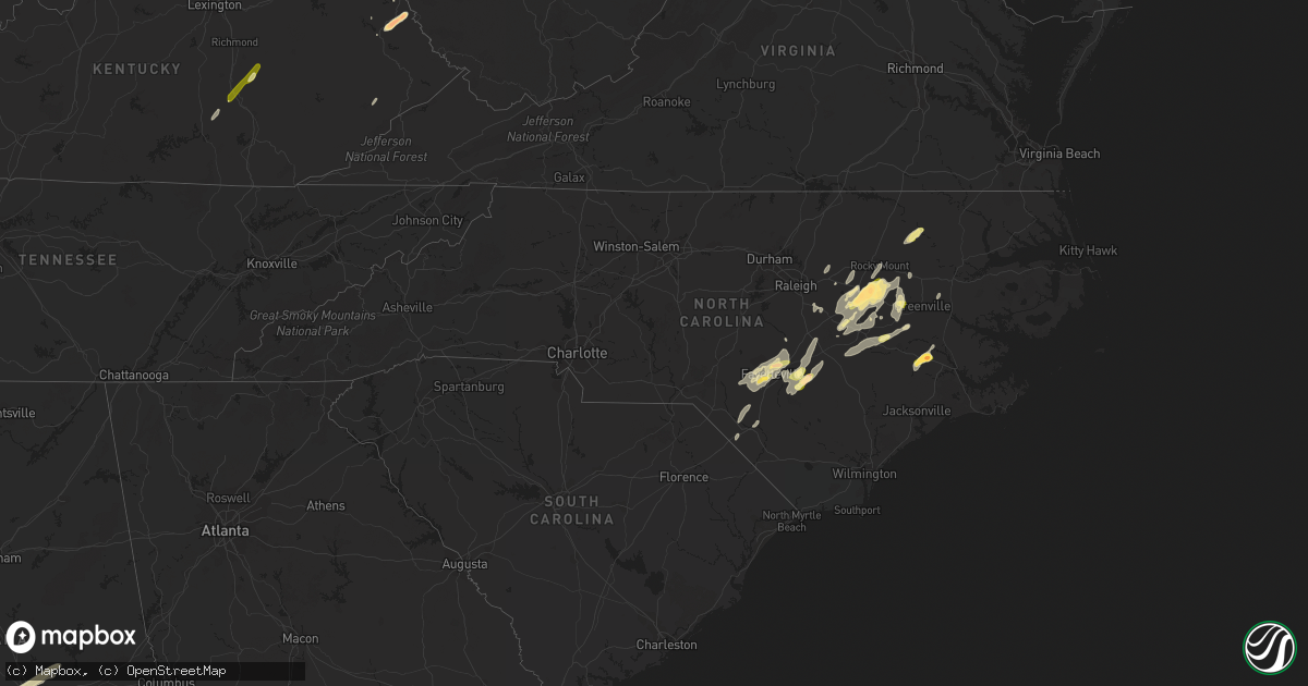
Hail Map in North Carolina on April 29, 2014
Get this storm
April 29 map
$229
one time, instant access
Download today. No call, no setup
Keep the $229
Bought the map and want the full workflow? Apply the entire $229 to a subscription within 7 days. None of it is wasted.
Every map, not just this one
This buys you this map. Subscription and you get every map we run, in the markets you choose from a few cities to whole states to nationwide. Plus real-time alerts the moment a storm fires.
Contact data
Name, contact info, occupancy, even credit band for addresses in the footprint. You go from where it hit to who to call.
Become the source they trust
Unlimited branding weather history reports on demand. You already have the documented answer ready for the property owner, and you are the one who showed up with it.
Property data and RoofTrace estimates
Pull up any address you have got, its value and the exact code rules for that jurisdiction, straight from One Click Code. Then RoofTrace estimates the squares, pitch, and roof value, priced the way you price.
Storm reports in North Carolina
North Carolina
| Date | Description |
|---|---|
| 04/29/20146:49 PM CDT | Fire dept reported tornado on the ground near shine. |
| 04/29/20146:41 PM CDT | Spotter reports tornado on the ground east of autryville... Report unconfirmed at this time |
| 04/29/20146:35 PM CDT | A local report indicates 1.00 inch wind near SALEMBURG |
| 04/29/20146:33 PM CDT | Quarter size hail |
| 04/29/20145:20 PM CDT | Tornado touchdown on mooring road. Roof blown off a residence. Numerous downed trees. Many other reports of minor structural damage and downed trees in this general are |
| 04/29/20144:56 PM CDT | County 911 reports debris blown across old wilson road. |
| 04/29/20144:35 PM CDT | A local report indicates 1.00 inch wind near 4 NNW HOPE MILLS |
| 04/29/20144:22 PM CDT | A local report indicates 60 MPH wind near FARMVILLE |
| 04/29/20144:20 PM CDT | Quarter size hail reported in farmville. |
| 04/29/20143:52 PM CDT | Quarter size hail at east langley road and bridgersville road |
| 04/29/20143:26 PM CDT | Golf ball size hail at tarboro st and glendale st |
| 04/29/20143:13 PM CDT | Golf ball size hail at the 911 center |
| 04/29/20143:12 PM CDT | Quarter to half dollar size hail covering the ground at tarboro st and glendale st |
| 04/29/20143:11 PM CDT | Golf ball size hail at hwy 117 |
| 04/29/20142:56 PM CDT | Damage to homes at hancock and john nunnery road |
| 04/29/20142:26 PM CDT | 2 trees down across the road at hwy 27 e and hwy 421 |
| 04/29/20142:26 PM CDT | 2 trees down across road at hwy 27e and hwy 421 near buies creek |
| 04/29/20141:26 PM CDT | Tornado observed while driving south on hwy-70 |
| 04/29/20141:25 PM CDT | Tornado briefly touched down in field between hwy-70 and cove city |
| 04/29/20141:10 PM CDT | A local report indicates 1.75 inch wind near 2 SSW COVE CITY |
| 04/28/20147:10 PM CDT | Possible tornado touchdown near intersection of juniper and church roads. Damage included a single-wide with significant damage and several out buildings destroyed. |
| 04/28/20147:04 PM CDT | Tornado reported on the ground near honeycutt road near salemburg... Report 3rd hand from scanner via skywarn |
All States Impacted by Hail Map on April 29, 2014
Cities Impacted by Hail Map on April 29, 2014
- Millbrook, AL
- Prattville, AL
- Wetumpka, AL
- Lowndesboro, AL
- Coosada, AL
- Montgomery, AL
- Fredericktown, OH
- Mansfield, OH
- Lucas, OH
- Bellville, OH
- Wilson, NC
- Remus, MI
- Six Lakes, MI
- Lakeview, MI
- Blanchard, MI
- Camden, AL
- Bidwell, OH
- Gallipolis, OH
- Monticello, MS
- Prentiss, MS
- Sontag, MS
- Silver Creek, MS
- Trufant, MI
- Coral, MI
- Howard City, MI
- Cedar Springs, MI
- Pierson, MI
- Sand Lake, MI
- East Palatka, FL
- Palatka, FL
- Hayneville, AL
- Eclectic, AL
- Kenly, NC
- Kent City, MI
- Sparta, MI
- Live Oak, FL
- White Springs, FL
- Roseboro, NC
- Autryville, NC
- Salemburg, NC
- Lena, MS
- Walnut Grove, MS
- Carthage, MS
- Philadelphia, MS
- Scotland Neck, NC
- Farmville, NC
- Fountain, NC
- Amite, LA
- Roseland, LA
- Black Creek, NC
- Lucama, NC
- Elm City, NC
- Jacksonville, FL
- Bogue Chitto, MS
- Brookhaven, MS
- Aberdeen, MS
- Coleman, MI
- Mendon, OH
- Rockford, OH
- Florala, AL
- Sanderson, FL
- Louisa, KY
- Ulysses, KY
- River, KY
- Polk City, FL
- Clermont, FL
- Groveland, FL
- Cheshire, OH
- Dudley, NC
- Beatrice, AL
- Franklin, AL
- Pine Apple, AL
- Vredenburgh, AL
- Dillon, SC
- Hamer, SC
- Walstonburg, NC
- Greenville, NC
- Hookerton, NC
- Okolona, MS
- Beaumont, MS
- New Augusta, MS
- Tutor Key, KY
- Lowmansville, KY
- Paintsville, KY
- Tomahawk, KY
- Logan, AL
- Cullman, AL
- Crane Hill, AL
- Conklin, MI
- Casnovia, MI
- Lake City, FL
- Macclesfield, NC
- Stantonsburg, NC
- Fremont, NC
- Middleport, OH
- Vinton, OH
- Coden, AL
- Cove City, NC
- Trenton, NC
- Mount Pleasant, MI
- Clare, MI
- Rosebush, MI
- Sims, NC
- Grant, MI
- Thurman, OH
- Long Bottom, OH
- Pomeroy, OH
- Rio Grande, OH
- Patriot, OH
- Oak Hill, OH
- Farwell, MI
- Lake, MI
- Parkton, NC
- Wade, NC
- Hope Mills, NC
- Fayetteville, NC
- Butler, OH
- Spring Hope, NC
- Bailey, NC
- Ocala, FL
- Lake Panasoffkee, FL
- Sandgap, KY
- McKee, KY
- Saucier, MS
- Vancleave, MS
- Raeford, NC
- Kingsland, GA
- Pinconning, MI
- Rhodes, MI
- Bentley, MI
- Halifax, NC
- Enfield, NC
- Amory, MS
- Smithville, MS
- Rockford, MI
- Newaygo, MI
- Comstock Park, MI
- Morley, MI
- Mecosta, MI
- Edmore, MI
- Weidman, MI
- Stanwood, MI
- Red Springs, NC
- Pinetops, NC
- Saint Marys, GA
- Yulee, FL
- Richmond, IN
- Snow Hill, NC
- La Grange, NC
- Reddick, FL
- Williston, FL
- Micanopy, FL
- Tyler, AL
- Kentwood, LA
- Greensburg, LA
- Lake Wales, FL
- Smithfield, NC
- Clayton, NC
- Kissimmee, FL
- Plant City, FL
- Valrico, FL
- Riverview, FL
- Dover, FL
- Lithia, FL
- Frostproof, FL
- Stedman, NC
- Holland, MI
- West Olive, MI
- Mount Vernon, KY
- Linwood, MI
- Tuscumbia, AL
- Wiggins, MS
- Perkinston, MS
- Zellwood, FL
- Apopka, FL
- Hawthorne, FL
- Albany, OH
- Rutland, OH
- Langsville, OH
- Fernandina Beach, FL
- Rich Square, NC
- Perry, FL
- Coopersville, MI
- Satsuma, FL
- San Mateo, FL
- Hastings, FL
- Bunnell, FL
- Interlachen, FL
- Slaughter, LA
- Zachary, LA
- Pikeville, NC
- Thelma, KY
- Moultrie, GA
- Doerun, GA
- Beaverton, MI
- Dunn, NC
- Inez, KY
- Williamsport, KY
- Rowland, NC
- Pembroke, NC
- Lumberton, NC
- Hagerhill, KY
- Glen Saint Mary, FL
- Macclenny, FL
- Rocky Mount, NC
- Grand Bay, AL
- Bayou La Batre, AL
- Dade City, FL
- Hilliard, FL
- Callahan, FL
- Lucedale, MS
- Somerset, KY
- Princeton, NC
- Clinton, NC
- Pass Christian, MS
- Bay Saint Louis, MS
- Waveland, MS
- Tallahassee, FL
- Monticello, FL
- Starke, FL
- Lawtey, FL
- Lake Butler, FL
- Oviedo, FL
- New Brockton, AL
- Brooksville, FL
- Windermere, FL
- Winter Garden, FL
- Poplarville, MS
- Grand Haven, MI
- Pine Top, KY
- Mallie, KY
- Crescent City, FL
- Cherokee, AL
- Florence, AL
- Zebulon, NC
- Louisburg, NC
- Grifton, NC
- Indian Lake Estates, FL
- Coldwater, OH
- Celina, OH
- Fort Recovery, OH
- Diberville, MS
- Biloxi, MS
- Vanceboro, NC
- Elba, AL
- Reedsville, OH
- Mason, WV
- Racine, OH
- Fairmont, NC
- Theodore, AL
- Mobile, AL
- New Smyrna Beach, FL
- Linden, NC
- Fort Bragg, NC
- Lumber Bridge, NC
- Godwin, NC
- Galion, OH
- Melrose, FL
- Gladwin, MI
- Tarboro, NC
- Georgetown, FL
- Kawkawlin, MI
- Mount Olive, NC
- Goldsboro, NC
- Kinston, NC
- Seven Springs, NC
- McHenry, MS
- Pine Hill, AL
- Minter, AL
- Coy, AL
- Pomona Park, FL
- Lillington, NC
- Bunnlevel, NC
- Erwin, NC
- Morrison, TN
- Newton Grove, NC
- Benson, NC
- Gulfport, MS
- Sunbury, OH
- Thomaston, AL
- Catherine, AL
- Greenwell Springs, LA
- Four Oaks, NC
- Collins, MS
- Smithdale, MS
- Coolville, OH
- Mount Vernon, OH
- Ashland, OH
- Shiloh, OH
- Flatgap, KY
- Marne, MI
- Grand Rapids, MI
- Saint George, GA
- Seville, FL
- Pierson, FL
- Midland, MI
- Hope, MI
- Selma, NC
- Middlesex, NC
- Florahome, FL
- Saraland, AL
- Dover, NC
- Orlando, KY
- Livingston, KY
- West Columbia, WV


