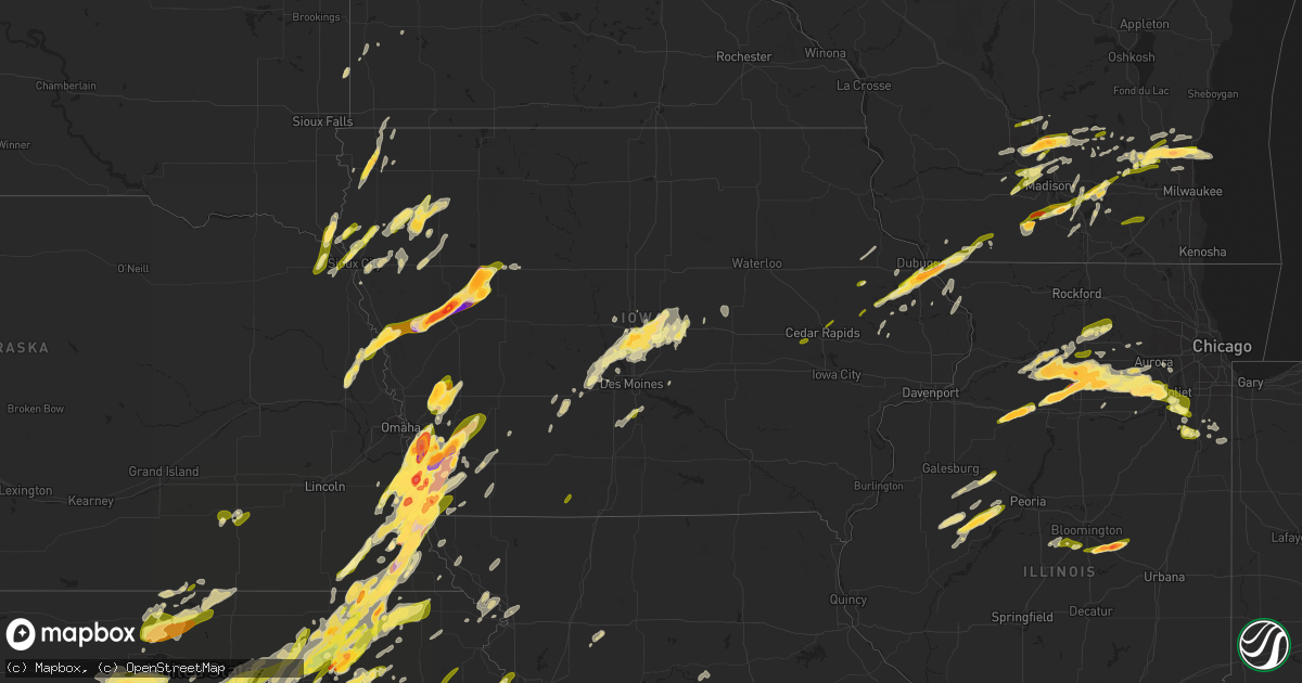
Hail Map in Iowa on April 19, 2023
Get this storm
April 19 map
$229
one time, instant access
Download today. No call, no setup
Keep the $229
Bought the map and want the full workflow? Apply the entire $229 to a subscription within 7 days. None of it is wasted.
Every map, not just this one
This buys you this map. Subscription and you get every map we run, in the markets you choose from a few cities to whole states to nationwide. Plus real-time alerts the moment a storm fires.
Contact data
Name, contact info, occupancy, even credit band for addresses in the footprint. You go from where it hit to who to call.
Become the source they trust
Unlimited branding weather history reports on demand. You already have the documented answer ready for the property owner, and you are the one who showed up with it.
Property data and RoofTrace estimates
Pull up any address you have got, its value and the exact code rules for that jurisdiction, straight from One Click Code. Then RoofTrace estimates the squares, pitch, and roof value, priced the way you price.
Storm reports in Iowa
Iowa
| Date | Description |
|---|---|
| 04/19/20236:50 PM CDT | Report from mping: golf ball |
| 04/19/20236:36 PM CDT | Public reported via social media hail approximately 2 inches in diameter. |
| 04/19/20236:31 PM CDT | Report from mping: golf ball |
| 04/19/20236:28 PM CDT | A local report indicates 1.50 inch wind near BLENCOE |
| 04/19/20236:13 PM CDT | Trained storm spotter reported quarter size hail. |
| 04/19/20236:10 PM CDT | Report from mping: quarter |
| 04/19/20236:08 PM CDT | A local report indicates 2.00 inch wind near 1 S SIDNEY |
| 04/19/20236:08 PM CDT | A local report indicates 2.00 inch wind near MINDEN |
| 04/19/20236:00 PM CDT | Delayed report: golf ball and tennis ball size hail. Damage to siding... Roof and car windows. |
| 04/19/20235:47 PM CDT | Delayed report. |
| 04/19/20235:44 PM CDT | A local report indicates 1.00 inch wind near 4 NW SILVER CITY |
| 04/19/20235:38 PM CDT | A local report indicates 2.00 inch wind near GLENWOOD |
| 04/19/20235:37 PM CDT | A local report indicates 1.25 inch wind near GLENWOOD |
| 04/19/20235:29 PM CDT | A local report indicates 1.75 inch wind near 5 NNW THURMAN |
| 04/19/20235:28 PM CDT | Public photo of measured 3 inch hail stone near thurman. Time estimated based on radar and nearby reports. |
| 04/19/20235:27 PM CDT | A local report indicates 1.50 inch wind near 3 W THURMAN |
| 04/19/202311:37 AM CDT | A local report indicates 1.75 inch wind near 2 E DUBUQUE REGIONAL AR |
| 04/19/202311:34 AM CDT | A local report indicates 1.75 inch wind near 1 NE DUBUQUE REGIONAL A |
| 04/19/202311:30 AM CDT | Report from mping: quarter |
| 04/19/202311:10 AM CDT | Quarter size hail. |
| 04/19/202311:03 AM CDT | Mostly peas with a few quarter sized hail. |
| 04/19/202310:41 AM CDT | Hail falling last 10 minutes. Mostly around nickel size with a couple around 1 inch. |
| 04/19/202310:25 AM CDT | A local report indicates 1.00 inch wind near 1 ENE ANAMOSA |
| 04/19/20239:56 AM CDT | Mostly pea sized. |
| 04/19/20239:55 AM CDT | A local report indicates 1.00 inch wind near 1 NNW HOPKINTON |
| 04/19/20239:30 AM CDT | Time estimated. |
| 04/19/20232:45 AM CDT | Hail lasted 2 minutes. Delayed report. |
| 04/18/202311:11 PM CDT | A local report indicates 1.00 inch wind near 1 SE SAYLORVILLE |
| 04/18/202311:10 PM CDT | A local report indicates 1.00 inch wind near MELBOURNE |
| 04/18/202310:56 PM CDT | 54 kt gust on asos. |
| 04/18/202310:48 PM CDT | Report from mping: quarter |
| 04/18/202310:44 PM CDT | A local report indicates 1.00 inch wind near 2 NW COLLINS |
| 04/18/202310:37 PM CDT | Em relayed report of quarter to silver dollar sized hail. |
| 04/18/202310:17 PM CDT | Em relayed report of silver dollar sized hail. |
| 04/18/202310:16 PM CDT | A local report indicates 1.50 inch wind near HUXLEY |
| 04/18/20239:56 PM CDT | A local report indicates 1.00 inch wind near MOUNT AYR |
| 04/18/20239:43 PM CDT | Dispatch relayed deputy report of nickel to quarter sized hail at 190th and v ave. |
| 04/18/20239:32 PM CDT | A local report indicates 60 MPH wind near TREYNOR |
| 04/18/20239:20 PM CDT | A local report indicates 1.50 inch wind near DOON |
| 04/18/20239:14 PM CDT | A local report indicates 1.00 inch wind near ROCK VALLEY |
| 04/18/20239:04 PM CDT | A local report indicates 1.00 inch wind near REMSEN |
| 04/18/20238:42 PM CDT | A local report indicates 1.00 inch wind near MERRILL |
| 04/18/20238:38 PM CDT | Delayed report... Time estimated by radar. |
| 04/18/20238:30 PM CDT | Public report via media. Location and timing estimated using radar data. |
| 04/18/20238:30 PM CDT | Report from mping: quarter |
| 04/18/20238:29 PM CDT | A local report indicates 1.25 inch wind near 2 NW GLENWOOD |
| 04/18/20238:27 PM CDT | Multiple photographs appear to confirm tornado in this area at 8:27 pm. |
| 04/18/20238:27 PM CDT | A local report indicates 1.75 inch wind near WALL LAKE |
| 04/18/20238:23 PM CDT | A local report indicates 1.00 inch wind near 3 WNW GLENWOOD |
| 04/18/20238:23 PM CDT | Updated report: multiple photographs and accounts from storm chasers and public confirm a tornado in this approximate location that lasted for approximately 3 minutes. |
| 04/18/20238:23 PM CDT | Penny to quarter sized with ponding of water on roads in town. |
| 04/18/20238:16 PM CDT | Likely tornado supported by storm chaser photos at this location. |
| 04/18/20238:16 PM CDT | Updated report: multiple photographs and reports from storm chasers and public confirm a brief tornado near this location. No damage was reported. |
| 04/18/20238:14 PM CDT | A local report indicates 1.00 inch wind near 5 WNW SIOUX CITY |
| 04/18/20238:10 PM CDT | Corrects previous hail report from 7 ese westfield. Hail lasted for 5 minutes. |
| 04/18/20238:09 PM CDT | End of period of occasional hail to quarter size. |
| 04/18/20238:06 PM CDT | A local report indicates a tornado near 3 S KIRON |
| 04/18/20238:05 PM CDT | Social media report with pictures. |
| 04/18/20238:05 PM CDT | Hail lasted for 5 minutes. |
| 04/18/20238:00 PM CDT | Delayed report - severely damaged car with hail covered ground. |
| 04/18/20237:54 PM CDT | A local report indicates 1.00 inch wind near 8 S ARTHUR |
| 04/18/20237:43 PM CDT | A local report indicates 1.50 inch wind near CLEGHORN |
| 04/18/20237:37 PM CDT | A local report indicates 1.75 inch wind near HAMBURG |
| 04/18/20237:22 PM CDT | Significant car damage reported. |
| 04/18/20237:11 PM CDT | A local report indicates a tornado near 5 E MACEDONIA |
| 04/18/20237:10 PM CDT | Updated report: multiple photos... Videos... And reports confirm that a brief 30 second long ground circulation developed below a long-lived funnel cloud in this approx |
| 04/18/20237:05 PM CDT | A local report indicates 1.00 inch wind near HAMBURG |
| 04/18/20237:00 PM CDT | Trained spotter reported quarter sized hail covering the ground in ute. |
All States Impacted by Hail Map on April 19, 2023
Cities Impacted by Hail Map on April 19, 2023
- Fort Dodge, IA
- Badger, IA
- Vincent, IA
- Thor, IA
- Humboldt, IA
- Eagle Grove, IA
- Norway, IA
- Fairfax, IA
- Marion, IA
- Cedar Rapids, IA
- Hopkinton, IA
- Anamosa, IA
- Monticello, IA
- Cascade, IA
- Bernard, IA
- Dane, WI
- Lodi, WI
- Arlington, WI
- Mount Horeb, WI
- Cross Plains, WI
- Verona, WI
- Middleton, WI
- Waunakee, WI
- Mazomanie, WI
- Black Earth, WI
- Zwingle, IA
- Dubuque, IA
- East Dubuque, IL
- Peosta, IA
- La Motte, IA
- Bellevue, IA
- Galena, IL
- Hazel Green, WI
- Yates City, IL
- Williamsfield, IL
- Elmwood, IL
- Laura, IL
- Brimfield, IL
- Shullsburg, WI
- Scales Mound, IL
- Benton, WI
- Cuba City, WI
- Cuba, IL
- Smithfield, IL
- Canton, IL
- Glasford, IL
- Farmington, IL
- Trivoli, IL
- Windsor, WI
- Deforest, WI
- Avon, IL
- Ellisville, IL
- Marietta, IL
- Maquon, IL
- London Mills, IL
- Lewistown, IL
- Ipava, IL
- Saint Augustine, IL
- Bushnell, IL
- Macomb, IL
- Dyersville, IA
- New Vienna, IA
- Earlville, IA
- Fairview, IL
- Gilson, IL
- Blue Mounds, WI
- Hanna City, IL
- Baraboo, WI
- Portage, WI
- Poynette, WI
- Oregon, WI
- Stoughton, WI
- Rio, WI
- Watertown, WI
- Johnson Creek, WI
- Jefferson, WI
- Lake Mills, WI
- Cambridge, WI
- Fort Atkinson, WI
- Sheffield, IL
- Neponset, IL
- Wyanet, IL
- Princeton, IL
- Beaver Dam, WI
- Buda, IL
- Hartford, WI
- Slinger, WI
- Ohio, IL
- Malden, IL
- La Moille, IL
- West Bend, WI
- Arlington, IL
- Mendota, IL
- Richfield, WI
- Jackson, WI
- Cedarburg, WI
- Grafton, WI
- Saukville, WI
- Amboy, IL
- Sublette, IL
- West Brooklyn, IL
- Compton, IL
- Earlville, IL
- Heyworth, IL
- Downs, IL
- Le Roy, IL
- Arrowsmith, IL
- Paw Paw, IL
- Steward, IL
- Shabbona, IL
- Leland, IL
- Sheridan, IL
- Chickasha, OK
- Cement, OK
- Somonauk, IL
- Ninnekah, OK
- Bellflower, IL
- Sandwich, IL
- Amber, OK
- Apache, OK
- Newark, IL
- Millington, IL
- Plano, IL
- Yorkville, IL
- Millbrook, IL
- Tuttle, OK
- Cyril, OK
- Fletcher, OK
- Union, NE
- Nebraska City, NE
- Oconomowoc, WI
- Rubicon, WI
- Thurman, IA
- Hubertus, WI
- Oklahoma City, OK
- Newcastle, OK
- Mustang, OK
- McLean, IL
- Ashton, IL
- Armington, IL
- Minier, IL
- Madison, WI
- Waterloo, WI
- Columbus, WI
- Hartland, WI
- Neosho, WI
- Sun Prairie, WI
- Reeseville, WI
- Kewaskum, WI
- Fredonia, WI
- Dekalb, IL
- Sycamore, IL
- Clare, IL
- Trent, SD
- Theresa, WI
- Mayville, WI
- Allenton, WI
- Kirkland, IL
- Malta, IL
- Rochelle, IL
- Esmond, IL
- Prairie Du Sac, WI
- Kewanee, IL
- Ixonia, WI
- Randolph, WI
- Cambria, WI
- Fall River, WI
- Juneau, WI
- Mineral, IL
- Shirley, IL
- Doylestown, WI
- Germantown, WI
- Elgin, OK
- Franklin Grove, IL
- Waterman, IL
- Ashippun, WI
- Mequon, WI
- Hustisford, WI
- Gratiot, WI
- Darlington, WI
- Lowell, WI
- Harmon, IL
- Lee, IL
- Dixon, IL
- Walnut, IL
- Rock Falls, IL
- Dover, IL
- Deer Grove, IL
- Plattsmouth, NE
- Pacific Junction, IA
- Anadarko, OK
- Carnegie, OK
- Mountain View, OK
- Herman, NE
- Hooper, NE
- Winslow, NE
- Wheatland, OK
- Craig, NE
- Humboldt, NE
- Blanchard, OK
- Minooka, IL
- Fort Cobb, OK
- Glenwood, IA
- Tabor, IA
- Malvern, IA
- Edmond, OK
- Jones, OK
- Joliet, IL
- Shorewood, IL
- Plainfield, IL
- Arcadia, OK
- Percival, IA
- Washington, OK
- Norman, OK
- Channahon, IL
- Tekamah, NE
- Minco, OK
- Blencoe, IA
- Decatur, NE
- Union City, OK
- Yukon, OK
- El Reno, OK
- Onawa, IA
- Auburn, NE
- Stella, NE
- Verden, OK
- Brock, NE
- Peru, NE
- Julian, NE
- Rock Port, MO
- Hamburg, IA
- Sidney, IA
- Brownville, NE
- Bethany, OK
- Piedmont, OK
- Silver City, IA
- Halstead, KS
- Mineola, IA
- Durham, KS
- Hinton, OK
- Lookeba, OK
- Calumet, OK
- Geary, OK
- Tampa, KS
- Hastings, IA
- Emerson, IA
- Henderson, IA
- Ramona, KS
- Elwood, IL
- Luther, OK
- Perkins, OK
- Wellston, OK
- Meridian, OK
- Guthrie, OK
- Carney, OK
- Coyle, OK
- Wilmington, IL
- Manhattan, IL
- Soldier, IA
- Castana, IA
- Moorhead, IA
- Johnson, NE
- Baileyville, KS
- Home, KS
- Beattie, KS
- Gracemont, OK
- Okarche, OK
- Kingfisher, OK
- Blue Rapids, KS
- Falls City, NE
- Axtell, KS
- Sabetha, KS
- Seneca, KS
- Craig, MO
- Frankfort, KS
- Bern, KS
- Salem, NE
- Table Rock, NE
- Pawnee City, NE
- Stillwater, OK
- Ripley, OK
- Glencoe, OK
- Chapman, KS
- Junction City, KS
- Yale, OK
- Milford, KS
- Fort Riley, KS
- Watson, MO
- Riley, KS
- Pocasset, OK
- Randolph, IA
- Riverton, IA
- Farragut, IA
- Imogene, IA
- Red Oak, IA
- Peabody, KS
- Minden, IA
- Underwood, IA
- Neola, IA
- Davidson, OK
- Frederick, OK
- Hancock, IA
- Loveland, OK
- Hollister, OK
- Avoca, IA
- Shelby, IA
- Chattanooga, OK
- Walters, OK
- Marion, KS
- Florence, KS
- Choctaw, OK
- Persia, IA
- Harlan, IA
- Portsmouth, IA
- Manhattan, KS
- Leonardville, KS
- Macedonia, IA
- Carson, IA
- Griswold, IA
- Pawnee, OK
- Randolph, KS
- Olsburg, KS
- Westmoreland, KS
- Onaga, KS
- Charter Oak, IA
- Mapleton, IA
- Ute, IA
- Walton, KS
- Ricketts, IA
- Cedar Point, KS
- Vermillion, KS
- Allen, NE
- Waterbury, NE
- Jackson, NE
- Ponca, NE
- Elliott, IA
- Oakland, IA
- Walnut, IA
- Lewis, IA
- Atlantic, IA
- Centralia, KS
- Talmage, NE
- Schleswig, IA
- Denison, IA
- Ida Grove, IA
- Newalla, OK
- Spencer, OK
- Harrah, OK
- Purcell, OK
- Noble, OK
- Lexington, OK
- Du Bois, NE
- Elmdale, KS
- Strong City, KS
- Elk Point, SD
- Jefferson, SD
- Kiron, IA
- Deloit, IA
- Arthur, IA
- Odebolt, IA
- Merkel, TX
- Tuscola, TX
- Abilene, TX
- Dyess Afb, TX
- Tye, TX
- Cleghorn, IA
- Marcus, IA
- Paullina, IA
- Meriden, IA
- Hennessey, OK
- Marshall, OK
- Crescent, OK
- Orlando, OK
- Covington, OK
- Perry, OK
- Lucien, OK
- Mulhall, OK
- Cottonwood Falls, KS
- Morrison, OK
- Tecumseh, OK
- Faxon, OK
- Geronimo, OK
- Lawton, OK
- Cache, OK
- Emporia, KS
- Grandfield, OK
- Devol, OK
- Randlett, OK
- Temple, OK
- Marlow, OK
- Duncan, OK
- Hinton, IA
- Merrill, IA
- Le Mars, IA
- Comanche, OK
- Dakota City, NE
- South Sioux City, NE
- North Sioux City, SD
- Sioux City, IA
- Americus, KS
- Lake View, IA
- Wall Lake, IA
- Vail, IA
- Breda, IA
- Early, IA
- Sac City, IA
- Fonda, IA
- Nehawka, NE
- Murray, NE
- Mcloud, OK
- Allen, KS
- Shawnee, OK
- Moline, KS
- Grenola, KS
- Howard, KS
- Rock Valley, IA
- Sioux Center, IA
- Doon, IA
- Hull, IA
- Macomb, OK
- Admire, KS
- Meeker, OK
- Prague, OK
- Clyde, TX
- Dallas Center, IA
- Woodward, IA
- Granger, IA
- Madrid, IA
- Polk City, IA
- Brayton, IA
- Lawton, IA
- Sergeant Bluff, IA
- Dawson, NE
- Pipestone, MN
- Holland, MN
- Saint George, KS
- Westfield, IA
- Akron, IA
- Flandreau, SD
- Clarinda, IA
- Steinauer, NE
- Elk Creek, NE
- Grant Park, IL
- Milwaukee, WI
- Bourbonnais, IL
- Manteno, IL
- Crest Hill, IL
- Council Grove, KS
- Sussex, WI
- Colgate, WI
- Menomonee Falls, WI
- Milton, WI
- Edgerton, WI
- Janesville, WI
- Evansville, WI
- Hubbard, NE
- Red Rock, OK
- Marland, OK
- Ponca City, OK
- Shidler, OK
- Burbank, OK
- Council Bluffs, IA
- Salix, IA
- Bolingbrook, IL
- Naperville, IL
- Villisca, IA
- Dunbar, NE
- Wilsey, KS
- Alma, KS
- Oswego, IL
- Cedar Vale, KS
- Kankakee, IL
- Albany, TX
- Berryton, KS
- Tecumseh, KS
- Correctionville, IA
- Pierson, IA
- Kingsley, IA
- Burlingame, KS
- Wakarusa, KS
- Topeka, KS
- Auburn, KS
- Carbondale, KS
- Harveyville, KS
- Nickerson, NE
- Momence, IL
- Treynor, IA
- Balaton, MN
- Little Sioux, IA
- Alta Vista, KS
- Dwight, KS
- Alvord, IA
- Inwood, IA
- Lehigh, KS
- White City, KS
- Maple Park, IL
- Summerfield, KS
- Delia, KS
- Eldena, IL
- Belleville, WI
- Lockport, IL
- New Lenox, IL
- Aurora, IL
- Sugar Grove, IL
- Bristol, IL
- Montgomery, IL
- Romeoville, IL
- New Glarus, WI
- Albany, WI
- Monticello, WI
- Wamego, KS
- Otoe, NE
- Avoca, NE
- Syracuse, NE
- Anthon, IA
- Burchard, NE
- Cook, NE
- Tecumseh, NE
- Hillsboro, KS
- Herington, KS
- Brooklyn, WI
- Eskridge, KS
- Lecompton, KS
- Reading, KS
- Nemaha, NE
- Marysville, KS
- Waterville, KS
- Farmer City, IL
- Slater, IA
- Hinckley, IL
- Sheldahl, IA
- Huxley, IA
- Cambridge, IA
- Kelley, IA
- Elkhart, IA
- Ames, IA
- Sparks, OK
- Paden, OK
- Nevada, IA
- Maxwell, IA
- Mount Ayr, IA
- Colo, IA
- Collins, IA
- Zearing, IA
- Indianola, IA
- State Center, IA
- Lawrence, KS
- Perry, KS
- McLouth, KS
- Oskaloosa, KS
- Tonganoxie, KS
- Saint Anthony, IA
- Basehor, KS
- Leavenworth, KS
- Rhodes, IA
- Melbourne, IA
- Boley, OK
- Castle, OK
- Marshalltown, IA
- Okemah, OK
- Okmulgee, OK
- Weleetka, OK
- Henryetta, OK
- Morris, OK
- Downs, KS
- Esbon, KS
- Gaylord, KS
- Paradise, KS
- Waldo, KS
- Natoma, KS
- Osborne, KS
- Lucas, KS
- Luray, KS
- Burns, KS
- Sylvan Grove, KS
- Hunter, KS
- Tipton, KS
- Mankato, KS
- Lebanon, KS
- Wymore, NE
- Liberty, NE
- Blue Springs, NE
- Jewell, KS
- Beloit, KS
- Crab Orchard, NE
- Virginia, NE
- Lewiston, NE
- Sutton, NE
- Grafton, NE
- Geneva, NE
- Formoso, KS
- Courtland, KS
- Webber, KS
- Delphos, KS
- Minneapolis, KS
- Miltonvale, KS
- Aurora, KS
- Ellsworth, KS
- Kanopolis, KS
- Claflin, KS
- Bushton, KS
- Ellinwood, KS
- Fairmont, NE
- Exeter, NE
- Geneseo, KS
- Lorraine, KS
- Brookville, KS
- Superior, NE
- Clay Center, KS
- Morganville, KS
- Salina, KS
- Green, KS
- Greenleaf, KS
- Barnes, KS
- Wakefield, KS
- Meriden, KS
- Valley Falls, KS
- Ozawkie, KS
- Ottawa, KS
- George, IA
- Rock Rapids, IA
- Lytton, IA
- Hardy, NE
- Yates Center, KS
- Jolley, IA
- Johnston, IA
- Horicon, WI
- Iron Ridge, WI
- Gladbrook, IA
- Toledo, IA
- Garwin, IA
- Traer, IA
- Cherokee, IA
- Prole, IA
- Saint Marys, IA
- Saint Charles, IA
- New Virginia, IA
- Polo, MO
- Redfield, IA
- Dexter, IA
- Earlham, IA
- Weeping Water, NE
- Sutherland, IA
- Larrabee, IA
- Remsen, IA
- Calumet, IA
- Waukee, IA
- Clive, IA
- Sedan, KS
- Savannah, MO
- Cosby, MO
- Saint Joseph, MO
- Pawhuska, OK
- Amazonia, MO
- Oregon, MO
- Wathena, KS
- Troy, KS
- Whitewater, KS
- Boyden, IA
- Stuart, IA
- Belleville, KS
- Republic, KS
- Robinson, KS
- Havensville, KS
- Cambridge, KS
- Dexter, KS
- Matfield Green, KS
- Lebo, KS
- Burr Oak, KS
- Menlo, IA
- Kansas City, KS
- Saint Marys, KS
- Emmett, KS
- Byron, NE
- Chester, NE
- Shenandoah, IA
- Essex, IA
- Clyde, KS
- Clifton, KS
- Palmer, KS
- Woodbine, KS
- Greenfield, IA
- Alton, KS
- Plainville, KS
- Moville, IA
- Neosho Rapids, KS
- Baird, TX
- Barnard, MO
- Graham, MO
- Skidmore, MO
- Burdick, KS
- Wilson, KS
- Holyrood, KS
- Lincoln, KS
- Holstein, IA
- Cushing, IA
- Washta, IA
- Ellsworth, MN
- Hawarden, IA
- Magnolia, MN
- Bondurant, IA
- Minburn, IA
- Clemons, IA
- Adel, IA
- Alleman, IA
- Grimes, IA
- Albion, IA
- Ankeny, IA
- Prairie City, IA
- Hamilton, MO
- Valley Center, KS
- Beverly, KS
- Horton, KS
- Whiting, KS
- Cowgill, MO
- Kingston, MO
- Oneida, KS
- Potwin, KS
- Orient, IA
- Bronson, IA
- Madison, KS
- Kansas City, MO
- Waldron, MO
- Platte City, MO
- Lansing, KS
- Northboro, IA
- Coin, IA
- Olpe, KS
- Silver Lake, KS
- Quimby, IA
- Aurelia, IA
- Scranton, KS
- Fairfax, MO
- Barnard, KS
- Smith Center, KS
- Elk Falls, KS
- Abilene, KS
- Sterling, NE
- Lorton, NE
- McClelland, IA
- Longford, KS
- Tescott, KS
- Hartford, KS
- Earlsboro, OK
- Wellsville, KS
- Baldwin City, KS
- Edgerton, KS
- Eudora, KS
- Gardner, KS
- Nortonville, KS
- Linwood, KS
- Goff, KS
- Corning, KS
- Fairview, KS
- Morrill, KS
- Hiawatha, KS
- South Wayne, WI
- Melvern, KS
- Baldwin, IA
- Monmouth, IA
- Hanover, KS
- Whitewater, WI
- Maple Hill, KS
- Olin, IA
- Paxico, KS
- Deerfield, WI
- Marshall, WI
- Pardeeville, WI
- Monroe, WI
- Onslow, IA
- Wyoming, IA
- Great Bend, KS
- Olmitz, KS
- Hoisington, KS
- Clarence, IA
- Oxford Junction, IA
- Stanford, IL
- Soldier, KS
- Bonfield, IL
- Belvue, KS
- Westphalia, KS
- Miles, IA
- Hanover, IL
- Savanna, IL
- Platteville, WI
- Richmond, KS
- Pomona, KS
- Williamsburg, KS
- Quenemo, KS
- Highland, KS
- Mayetta, KS
- Princeton, KS
- Drumright, OK
- Belton, MO
- Stilwell, KS
- Grandview, MO
- Louisburg, KS
- Bucyrus, KS
- Paola, KS
- Spring Hill, KS
- Dover, OK
- Stanton, IA
- Cumberland, IA
- Enterprise, KS
- Boone, IA
- Epworth, IA
- Clinton, IL
- Oketo, KS
- Vassar, KS
- Lyndon, KS
- Overbrook, KS
- Concordia, KS
- Cushing, OK
- Lane, KS
- Rantoul, KS
- Osawatomie, KS
- Marengo, IA
- Hawley, TX
- Burnett, WI
- Ottawa, IL
- Preston, IA
- Story City, IA
- Elburn, IL
- Salisbury, MO
- Binger, OK
- Serena, IL
- Argyle, WI
- Elkhorn, WI
- East Troy, WI
- Eagle, WI
- Mukwonago, WI
- Kingston, IL
- Morris, IL
- Glasgow, MO
- Keytesville, MO
- Peotone, IL
- Cottage Grove, WI
- Fredericksburg, TX
- Harper, TX


