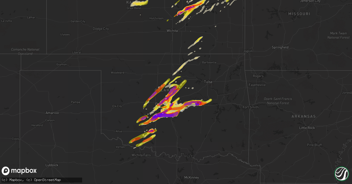
Hail Map on April 19, 2023
Get this storm
April 19 map
$229
one time, instant access
Download today. No call, no setup
Keep the $229
Bought the map and want the full workflow? Apply the entire $229 to a subscription within 7 days. None of it is wasted.
Every map, not just this one
This buys you this map. Subscription and you get every map we run, in the markets you choose from a few cities to whole states to nationwide. Plus real-time alerts the moment a storm fires.
Contact data
Name, contact info, occupancy, even credit band for addresses in the footprint. You go from where it hit to who to call.
Become the source they trust
Unlimited branding weather history reports on demand. You already have the documented answer ready for the property owner, and you are the one who showed up with it.
Property data and RoofTrace estimates
Pull up any address you have got, its value and the exact code rules for that jurisdiction, straight from One Click Code. Then RoofTrace estimates the squares, pitch, and roof value, priced the way you price.
States Impacted by Hail Map on April 19, 2023
Storm reports
Wisconsin
| Date | Description |
|---|---|
| 04/19/20235:15 PM CDT | A local report indicates 1.00 inch wind near 1 E HUBERTUS |
| 04/19/20235:01 PM CDT | A local report indicates 1.00 inch wind near 3 NNE LAC LA BELLE |
| 04/19/20234:57 PM CDT | A local report indicates 1.50 inch wind near 2 N ERIN |
| 04/19/20234:56 PM CDT | A local report indicates 1.00 inch wind near 1 NW IXONIA |
| 04/19/20234:48 PM CDT | A local report indicates 1.25 inch wind near 1 W ERIN |
| 04/19/20233:44 PM CDT | A local report indicates 1.00 inch wind near GRAFTON |
| 04/19/20233:36 PM CDT | A local report indicates 2.00 inch wind near 4 E JACKSON |
| 04/19/20233:36 PM CDT | Corrects previous hail report from 4 e jackson. |
| 04/19/20233:33 PM CDT | A local report indicates 1.75 inch wind near 3 ESE JACKSON |
| 04/19/20233:30 PM CDT | Time estimated from radar. |
| 04/19/20232:39 PM CDT | Report from mping: quarter |
| 04/19/20231:59 PM CDT | A local report indicates 1.50 inch wind near 1 E LAKE RIPLEY |
| 04/19/20231:47 PM CDT | A local report indicates 1.75 inch wind near 2 N POYNETTE |
| 04/19/20231:42 PM CDT | Multiple reports of quarter to half dollar size hail in the stoughton area. |
| 04/19/20231:41 PM CDT | A local report indicates 1.50 inch wind near 3 E LAKE WISCONSIN |
| 04/19/20231:40 PM CDT | Time estimated from radar. |
| 04/19/20231:38 PM CDT | A local report indicates 1.25 inch wind near 2 ESE LAKE WISCONSIN |
| 04/19/20231:37 PM CDT | Time estimated from radar. |
| 04/19/20231:30 PM CDT | Report from mping with additional reports and photos of quarter size hail on social media. |
| 04/19/20231:28 PM CDT | Report from mping: quarter |
| 04/19/20231:24 PM CDT | Time estimated from radar. |
| 04/19/20231:17 PM CDT | Time estimated from radar. |
| 04/19/20231:06 PM CDT | Time estimated from radar. |
| 04/19/202312:28 PM CDT | Time estimated from radar. |
| 04/19/202312:10 PM CDT | Delayed report of half dollar size hail. |
| 04/19/202312:10 PM CDT | Delayed report of half dollar size hail. . |
| 04/19/202312:05 PM CDT | Quarter size hail in many parts of lafayette county... Especially in the benton... Shullsburg and darlington areas. Time estimated from radar for first reports in bento |
| 04/19/202310:54 AM CDT | Report from mping: quarter |
| 04/19/202310:47 AM CDT | Multiple reports of quarter size hail north of middleton. Time radar estimated. |
| 04/19/202310:28 AM CDT | Report from mping: quarter |
| 04/19/202310:20 AM CDT | Report of nickel to quarter size hail via social media. Time radar estimated. |
Illinois
| Date | Description |
|---|---|
| 04/19/20235:55 PM CDT | Quarter sized hail reported at joliet junior college. |
| 04/19/20235:53 PM CDT | A local report indicates 1.00 inch wind near 1 WNW SHOREWOOD |
| 04/19/20235:49 PM CDT | Multiple reports of quarter sized hail in west shorewood relayed via mping. |
| 04/19/20235:44 PM CDT | Trained spotter reports quarter sized hail near ridge road and holt road north of minooka. |
| 04/19/20235:40 PM CDT | Trained spotter reports half dollar sized hail near caton farm road and county line road in west joliet. |
| 04/19/20235:40 PM CDT | Relayed via mping. |
| 04/19/20235:37 PM CDT | Trained spotter reports golf ball sized hail in west joliet. |
| 04/19/20235:26 PM CDT | Relayed via mping. |
| 04/19/20235:16 PM CDT | Dime to quarter sized hail near us34 and game farm road in yorkville. Time estimated by radar. |
| 04/19/20235:14 PM CDT | Trained spotter reports quarter sized hail near il71 and il47 in south yorkville. |
| 04/19/20234:46 PM CDT | Relayed via mping. |
| 04/19/20234:36 PM CDT | Relayed via broadcast media. |
| 04/19/20234:35 PM CDT | Photo shared via social media shows half dollar sized hail northeast of earlville. Time estimated by radar. |
| 04/19/20234:25 PM CDT | Trained spotter reports hail up to quarter sized southwest of steward near il251 and herman road. |
| 04/19/20234:20 PM CDT | Relayed via social media. Several small hailstones with a few 1 inch stones mixed it. |
| 04/19/20234:17 PM CDT | Delayed report. Photo relayed via broadcast media. Time estimated from radar. |
| 04/19/20234:17 PM CDT | Photo relayed via social media of ping pong to golf ball size hail. |
| 04/19/20234:17 PM CDT | Photo relayed via social media of golf ball size hail. |
| 04/19/20234:10 PM CDT | Photo relayed via social media. |
| 04/19/20234:03 PM CDT | Hail at least quarter sized reported in sublette. |
| 04/19/20233:58 PM CDT | Photo shared via social media shows hail of at least golf ball size north of earlville. Time estimated by radar... Location approximate. |
| 04/19/20233:54 PM CDT | Corrects previous hail report from 3 wnw sublette. Trained spotter reports quarter sized hail at woodhaven lakes. Time estimated by radar. |
| 04/19/20233:52 PM CDT | Social media pictures showed hail approximately quarter sized. Time estimated by radar. |
| 04/19/20233:48 PM CDT | Relayed via broadcast media. |
| 04/19/20233:44 PM CDT | Photo shows golf ball sized hail near meridan. Time estimated by radar. |
| 04/19/20233:42 PM CDT | Broken windshield from hail near i-39 mile marker 74 northeast of mendota. Hail size estimated. Time estimated by radar. |
| 04/19/20233:34 PM CDT | Photo shows 2 inch diameter hail near 46th road and il251. Time estimated by radar. |
| 04/19/20233:34 PM CDT | Photo shows quarter size hail in mendota near strobe avenue and 14th street. Time estimated by radar. |
| 04/19/20233:20 PM CDT | Picture sent to facebook. Time estimated from radar. |
| 04/19/20233:10 PM CDT | Photos of several quarter size hail stones. |
| 04/19/20232:56 PM CDT | A local report indicates 1.00 inch wind near 4 W DOVER |
| 04/19/20232:35 PM CDT | A local report indicates 1.75 inch wind near 1 NNE WYANET |
| 04/19/20232:28 PM CDT | Public photo from mm43 of ping pong sized hail. |
| 04/19/20232:28 PM CDT | A local report indicates 1.50 inch wind near 1 ESE SHEFFIELD |
| 04/19/20232:15 PM CDT | Relayed by broadcast media. |
| 04/19/20232:15 PM CDT | Relayed by broadcast media. |
| 04/19/202312:30 PM CDT | Pea to dime size hail with a few hailstones the size of quarters reported on twitter with photo. |
| 04/19/202312:25 PM CDT | Quarter to ping pong size hail at wee-ma-tuk reported on facebook with photo. |
| 04/19/202312:15 PM CDT | Emergency manager relayed report from social media of quarter to half dollar size hail in cuba. |
| 04/19/202311:54 AM CDT | A local report indicates 1.00 inch wind near 4 NW GALENA |
| 04/19/202311:36 AM CDT | A local report indicates 1.00 inch wind near EAST DUBUQUE |
| 04/18/20237:04 PM CDT | Photos and video shared to social media show quarter sized hail near 9000 north road and 3500 west road west of manteno. Time estimated by radar. |
| 04/18/20237:02 PM CDT | A local report indicates 1.25 inch wind near 3 NE BONFIELD |
Iowa
| Date | Description |
|---|---|
| 04/19/20236:50 PM CDT | Report from mping: golf ball |
| 04/19/20236:36 PM CDT | Public reported via social media hail approximately 2 inches in diameter. |
| 04/19/20236:31 PM CDT | Report from mping: golf ball |
| 04/19/20236:28 PM CDT | A local report indicates 1.50 inch wind near BLENCOE |
| 04/19/20236:13 PM CDT | Trained storm spotter reported quarter size hail. |
| 04/19/20236:10 PM CDT | Report from mping: quarter |
| 04/19/20236:08 PM CDT | A local report indicates 2.00 inch wind near 1 S SIDNEY |
| 04/19/20236:08 PM CDT | A local report indicates 2.00 inch wind near MINDEN |
| 04/19/20236:00 PM CDT | Delayed report: golf ball and tennis ball size hail. Damage to siding... Roof and car windows. |
| 04/19/20235:47 PM CDT | Delayed report. |
| 04/19/20235:44 PM CDT | A local report indicates 1.00 inch wind near 4 NW SILVER CITY |
| 04/19/20235:38 PM CDT | A local report indicates 2.00 inch wind near GLENWOOD |
| 04/19/20235:37 PM CDT | A local report indicates 1.25 inch wind near GLENWOOD |
| 04/19/20235:29 PM CDT | A local report indicates 1.75 inch wind near 5 NNW THURMAN |
| 04/19/20235:28 PM CDT | Public photo of measured 3 inch hail stone near thurman. Time estimated based on radar and nearby reports. |
| 04/19/20235:27 PM CDT | A local report indicates 1.50 inch wind near 3 W THURMAN |
| 04/19/202311:37 AM CDT | A local report indicates 1.75 inch wind near 2 E DUBUQUE REGIONAL AR |
| 04/19/202311:34 AM CDT | A local report indicates 1.75 inch wind near 1 NE DUBUQUE REGIONAL A |
| 04/19/202311:30 AM CDT | Report from mping: quarter |
| 04/19/202311:10 AM CDT | Quarter size hail. |
| 04/19/202311:03 AM CDT | Mostly peas with a few quarter sized hail. |
| 04/19/202310:41 AM CDT | Hail falling last 10 minutes. Mostly around nickel size with a couple around 1 inch. |
| 04/19/202310:25 AM CDT | A local report indicates 1.00 inch wind near 1 ENE ANAMOSA |
| 04/19/20239:56 AM CDT | Mostly pea sized. |
| 04/19/20239:55 AM CDT | A local report indicates 1.00 inch wind near 1 NNW HOPKINTON |
| 04/19/20239:30 AM CDT | Time estimated. |
| 04/19/20232:45 AM CDT | Hail lasted 2 minutes. Delayed report. |
| 04/18/202311:11 PM CDT | A local report indicates 1.00 inch wind near 1 SE SAYLORVILLE |
| 04/18/202311:10 PM CDT | A local report indicates 1.00 inch wind near MELBOURNE |
| 04/18/202310:56 PM CDT | 54 kt gust on asos. |
| 04/18/202310:48 PM CDT | Report from mping: quarter |
| 04/18/202310:44 PM CDT | A local report indicates 1.00 inch wind near 2 NW COLLINS |
| 04/18/202310:37 PM CDT | Em relayed report of quarter to silver dollar sized hail. |
| 04/18/202310:17 PM CDT | Em relayed report of silver dollar sized hail. |
| 04/18/202310:16 PM CDT | A local report indicates 1.50 inch wind near HUXLEY |
| 04/18/20239:56 PM CDT | A local report indicates 1.00 inch wind near MOUNT AYR |
| 04/18/20239:43 PM CDT | Dispatch relayed deputy report of nickel to quarter sized hail at 190th and v ave. |
| 04/18/20239:32 PM CDT | A local report indicates 60 MPH wind near TREYNOR |
| 04/18/20239:20 PM CDT | A local report indicates 1.50 inch wind near DOON |
| 04/18/20239:14 PM CDT | A local report indicates 1.00 inch wind near ROCK VALLEY |
| 04/18/20239:04 PM CDT | A local report indicates 1.00 inch wind near REMSEN |
| 04/18/20238:42 PM CDT | A local report indicates 1.00 inch wind near MERRILL |
| 04/18/20238:38 PM CDT | Delayed report... Time estimated by radar. |
| 04/18/20238:30 PM CDT | Public report via media. Location and timing estimated using radar data. |
| 04/18/20238:30 PM CDT | Report from mping: quarter |
| 04/18/20238:29 PM CDT | A local report indicates 1.25 inch wind near 2 NW GLENWOOD |
| 04/18/20238:27 PM CDT | A local report indicates 1.75 inch wind near WALL LAKE |
| 04/18/20238:27 PM CDT | Multiple photographs appear to confirm tornado in this area at 8:27 pm. |
| 04/18/20238:23 PM CDT | Penny to quarter sized with ponding of water on roads in town. |
| 04/18/20238:23 PM CDT | A local report indicates 1.00 inch wind near 3 WNW GLENWOOD |
| 04/18/20238:23 PM CDT | Updated report: multiple photographs and accounts from storm chasers and public confirm a tornado in this approximate location that lasted for approximately 3 minutes. |
| 04/18/20238:16 PM CDT | Updated report: multiple photographs and reports from storm chasers and public confirm a brief tornado near this location. No damage was reported. |
| 04/18/20238:16 PM CDT | Likely tornado supported by storm chaser photos at this location. |
| 04/18/20238:14 PM CDT | A local report indicates 1.00 inch wind near 5 WNW SIOUX CITY |
| 04/18/20238:10 PM CDT | Corrects previous hail report from 7 ese westfield. Hail lasted for 5 minutes. |
| 04/18/20238:09 PM CDT | End of period of occasional hail to quarter size. |
| 04/18/20238:06 PM CDT | A local report indicates a tornado near 3 S KIRON |
| 04/18/20238:05 PM CDT | Hail lasted for 5 minutes. |
| 04/18/20238:05 PM CDT | Social media report with pictures. |
| 04/18/20238:00 PM CDT | Delayed report - severely damaged car with hail covered ground. |
| 04/18/20237:54 PM CDT | A local report indicates 1.00 inch wind near 8 S ARTHUR |
| 04/18/20237:43 PM CDT | A local report indicates 1.50 inch wind near CLEGHORN |
| 04/18/20237:37 PM CDT | A local report indicates 1.75 inch wind near HAMBURG |
| 04/18/20237:22 PM CDT | Significant car damage reported. |
| 04/18/20237:11 PM CDT | A local report indicates a tornado near 5 E MACEDONIA |
| 04/18/20237:10 PM CDT | Updated report: multiple photos... Videos... And reports confirm that a brief 30 second long ground circulation developed below a long-lived funnel cloud in this approx |
| 04/18/20237:05 PM CDT | A local report indicates 1.00 inch wind near HAMBURG |
| 04/18/20237:00 PM CDT | Trained spotter reported quarter sized hail covering the ground in ute. |
Texas
| Date | Description |
|---|---|
| 04/18/202310:03 PM CDT | A local report indicates 1.00 inch wind near 3 ENE CLYDE |
| 04/18/20239:55 PM CDT | A local report indicates 1.00 inch wind near 1 NNE CLYDE |
| 04/18/20239:49 PM CDT | A local report indicates 1.00 inch wind near 1 NE CLYDE |
| 04/18/20239:04 PM CDT | A local report indicates 2.00 inch wind near 4 SSE ABILENE |
| 04/18/20239:01 PM CDT | A local report indicates 1.00 inch wind near 4 NNW POTOSI |
| 04/18/20239:00 PM CDT | Picture on facebook. Time estimated. |
| 04/18/20239:00 PM CDT | A local report indicates 2.50 inch wind near 4 NW POTOSI |
| 04/18/20238:58 PM CDT | A local report indicates 2.50 inch wind near 1 E KIRBY LAKE |
| 04/18/20238:56 PM CDT | A local report indicates 2.75 inch wind near 4 NW POTOSI |
| 04/18/20238:11 PM CDT | A local report indicates 1.00 inch wind near 2 SW IMPACT |
Missouri
| Date | Description |
|---|---|
| 04/19/202312:17 AM CDT | Carwash awning damaged... Power pole fell over... A couple dead trees pushed over. |
Oklahoma
| Date | Description |
|---|---|
| 04/19/20236:55 PM CDT | A local report indicates 1.00 inch wind near KINGFISHER |
| 04/19/20236:33 PM CDT | Report from mping: tea cup |
| 04/19/20236:30 PM CDT | A local report indicates 2.00 inch wind near 4 W EDMOND |
| 04/19/20236:22 PM CDT | Report from mping: half dollar |
| 04/19/20236:16 PM CDT | Report from mping: half dollar |
| 04/19/20236:15 PM CDT | A local report indicates 1.75 inch wind near 2 WNW THE VILLAGE |
| 04/19/20236:15 PM CDT | A local report indicates 1.25 inch wind near 4 NNW WARR ACRES |
| 04/19/20236:14 PM CDT | A local report indicates 1.50 inch wind near 5 S MOORE |
| 04/19/20236:14 PM CDT | Report from mping: golf ball |
| 04/19/20236:14 PM CDT | Report from mping: tennis ball |
| 04/19/20236:13 PM CDT | Report from mping: golf ball |
| 04/19/20236:09 PM CDT | Report from mping: ping pong ball |
| 04/19/20236:09 PM CDT | Report from mping: quarter |
| 04/19/20236:05 PM CDT | A local report indicates 1.75 inch wind near 1 ENE YUKON |
| 04/19/20236:05 PM CDT | Report received via social media. Time estimated via radar. |
| 04/19/20236:01 PM CDT | Report from mping: hen egg+ |
| 04/19/20236:01 PM CDT | A local report indicates 2.00 inch wind near 4 N THE VILLAGE |
| 04/19/20236:00 PM CDT | A local report indicates 1.50 inch wind near 1 N NEWCASTLE |
| 04/19/20235:59 PM CDT | Report from mping: golf ball |
| 04/19/20235:59 PM CDT | Report from mping: half dollar |
| 04/19/20235:58 PM CDT | Report from mping: tennis ball |
| 04/19/20235:55 PM CDT | Report from mping: hen egg |
| 04/19/20235:55 PM CDT | A local report indicates 1.75 inch wind near 1 NW EDMOND |
| 04/19/20235:55 PM CDT | A local report indicates 1.75 inch wind near 1 WSW NEWCASTLE |
| 04/19/20235:54 PM CDT | Report from mping: quarter |
| 04/19/20235:52 PM CDT | A local report indicates 2.25 inch wind near BRIDGE CREEK |
| 04/19/20235:50 PM CDT | Report from mping: hen egg |
| 04/19/20235:50 PM CDT | A local report indicates 1.75 inch wind near 1 ENE BLANCHARD |
| 04/19/20235:49 PM CDT | A local report indicates 1.50 inch wind near 3 N THE VILLAGE |
| 04/19/20235:49 PM CDT | A local report indicates 1.50 inch wind near 4 N THE VILLAGE |
| 04/19/20235:47 PM CDT | A local report indicates 2.00 inch wind near 2 NE BLANCHARD |
| 04/19/20235:46 PM CDT | Report from mping: baseball |
| 04/19/20235:45 PM CDT | Report from mping: half dollar |
| 04/19/20235:45 PM CDT | A local report indicates 1.00 inch wind near 1 SE NICHOLS HILLS |
| 04/19/20235:41 PM CDT | A local report indicates 1.00 inch wind near BLANCHARD |
| 04/19/20235:40 PM CDT | A local report indicates 1.00 inch wind near MUSTANG |
| 04/19/20235:39 PM CDT | A local report indicates 1.00 inch wind near MUSTANG |
| 04/19/20235:37 PM CDT | Report from mping: quarter |
| 04/19/20235:37 PM CDT | A local report indicates 1.00 inch wind near WILL ROGERS WORLD AIRPO |
| 04/19/20235:31 PM CDT | A local report indicates 1.00 inch wind near 6 WSW VALLEY BROOK |
| 04/19/20235:20 PM CDT | Report from mping: half dollar |
| 04/19/20235:18 PM CDT | A local report indicates 1.75 inch wind near CHICKASHA |
| 04/19/20235:08 PM CDT | Report from mping: quarter |
| 04/19/20235:07 PM CDT | A local report indicates 1.25 inch wind near 1 NE CHICKASHA |
| 04/19/20235:06 PM CDT | A local report indicates 1.25 inch wind near CHICKASHA |
| 04/19/20235:04 PM CDT | A local report indicates 1.00 inch wind near CHICKASHA |
| 04/19/202312:15 AM CDT | Report from mping: quarter |
| 04/18/202311:40 PM CDT | A local report indicates 3.75 inch wind near OKEMAH |
| 04/18/202311:30 PM CDT | A local report indicates 4.00 inch wind near 5 SE MASON |
| 04/18/202311:00 PM CDT | A local report indicates 1.75 inch wind near PADEN |
| 04/18/202310:03 PM CDT | Report from mping: quarter |
| 04/18/202310:00 PM CDT | A local report indicates 84 MPH wind near 3 NNW SHAWNEE |
| 04/18/20239:59 PM CDT | Damage reported in shawnee including at oklahoma baptist university and areas near i-40 and kickapoo road. The tornado likely began northwest of tecumseh around 941 pm |
| 04/18/20239:39 PM CDT | Report from mping: quarter |
| 04/18/20239:23 PM CDT | A local report indicates a tornado near 2 N BETHEL ACRES |
| 04/18/20239:16 PM CDT | Tornado debris signature evident on radar. Moved north-northwest to east of stella. |
| 04/18/20239:04 PM CDT | A local report indicates a tornado near 2 SSE PINK |
| 04/18/20239:00 PM CDT | Report from mping: hen egg |
| 04/18/20238:54 PM CDT | Report from mping: hen egg+ |
| 04/18/20238:48 PM CDT | The tornado moved northeast through 859 pm into pottawtomie county. |
| 04/18/20238:45 PM CDT | Report from mping: hen egg |
| 04/18/20238:38 PM CDT | A local report indicates a tornado near 3 W ETOWAH |
| 04/18/20238:24 PM CDT | A local report indicates 2.50 inch wind near 6 S STERLING |
| 04/18/20238:22 PM CDT | Report from mping: hen egg |
| 04/18/20238:20 PM CDT | Time estimated via radar. |
| 04/18/20238:20 PM CDT | A local report indicates 1.25 inch wind near 3 SE NORMAN |
| 04/18/20238:18 PM CDT | A local report indicates 1.75 inch wind near 4 W CENTRAL HIGH |
| 04/18/20238:15 PM CDT | A local report indicates 1.25 inch wind near 4 W VALLEY BROOK |
| 04/18/20238:11 PM CDT | A local report indicates 2.00 inch wind near 2 E NOBLE |
| 04/18/20238:10 PM CDT | Time estimated via radar. |
| 04/18/20238:04 PM CDT | Will rogers world airport. |
| 04/18/20237:33 PM CDT | A local report indicates a tornado near COLE |
| 04/18/20237:25 PM CDT | Report from mping: ping pong ball |
| 04/18/20237:25 PM CDT | Part of roof removed along with some vinyl siding. Also fence damage. |
| 04/18/20237:23 PM CDT | A local report indicates 2.50 inch wind near 1 SW BLANCHARD |
| 04/18/20237:18 PM CDT | A local report indicates 2.75 inch wind near TABLER |
| 04/18/20237:12 PM CDT | A local report indicates 2.00 inch wind near 1 E MIDWEST CITY |
| 04/18/20237:03 PM CDT | Tornado observed west of stanley draper lake moving northeast toward tinker afb. |
| 04/18/20237:00 PM CDT | Relayed by em. |
South Dakota
| Date | Description |
|---|---|
| 04/18/20238:13 PM CDT | A local report indicates 1.25 inch wind near 3 SSE NORTH SIOUX CITY |
| 04/18/20237:48 PM CDT | A local report indicates 1.00 inch wind near ELK POINT |
| 04/18/20237:48 PM CDT | Report received via social media. |
| 04/18/20237:44 PM CDT | A local report indicates 1.00 inch wind near ELK POINT |
Kansas
| Date | Description |
|---|---|
| 04/19/20236:57 PM CDT | Social media photo. |
| 04/19/20236:57 PM CDT | A local report indicates 1.50 inch wind near OLSBURG |
| 04/19/20236:56 PM CDT | Quarter size hail near ft. Riley. |
| 04/19/20236:50 PM CDT | A local report indicates 1.00 inch wind near WALTON |
| 04/19/20236:44 PM CDT | Corrects previous tstm wnd gst report from alta vista. Delayed report. |
| 04/19/20236:42 PM CDT | Report from mping: half dollar |
| 04/19/20236:40 PM CDT | Delayed report... Large tree limbs down. |
| 04/19/20236:38 PM CDT | A local report indicates 1.00 inch wind near 5 SSE MILFORD |
| 04/19/20236:36 PM CDT | Delayed report via photo social media. |
| 04/19/20236:36 PM CDT | Delayed report. |
| 04/19/20236:34 PM CDT | A local report indicates 1.75 inch wind near 3 NW JUNCTION CITY |
| 04/19/20236:34 PM CDT | A local report indicates 1.75 inch wind near 5 NNW JUNCTION CITY |
| 04/19/20236:30 PM CDT | Corrects previous hail report from 5 ene chapman. Delayed report. |
| 04/19/20236:27 PM CDT | Photo on social media. |
| 04/19/20236:26 PM CDT | Delayed report. |
| 04/19/20236:25 PM CDT | Lasted from 6:15-6:25 pm. |
| 04/19/20236:15 PM CDT | A local report indicates 1.25 inch wind near DURHAM |
| 04/19/20236:00 PM CDT | A local report indicates 1.75 inch wind near 1 S BAILEYVILLE |
| 04/19/20235:57 PM CDT | Social media photo. |
| 04/19/20235:52 PM CDT | A local report indicates 1.25 inch wind near 6 WSW BEATTIE |
| 04/19/20235:50 PM CDT | Strong winds took off a roof to a greenhouse and damaged a shed. |
| 04/19/20235:50 PM CDT | A local report indicates 1.25 inch wind near 5 E MARYSVILLE |
| 04/19/20235:38 PM CDT | A local report indicates 1.00 inch wind near HALSTEAD |
| 04/19/20234:00 AM CDT | Several large trees... At least a foot in diameter... Have been blown down. |
| 04/19/20233:55 AM CDT | A local report indicates 1.00 inch wind near LEAVENWORTH |
| 04/19/20233:41 AM CDT | A local report indicates 1.25 inch wind near TONGANOXIE |
| 04/19/20233:37 AM CDT | Ground is covered with quarter-sized hail. |
| 04/19/20233:34 AM CDT | Noted tree limbs down... But could not estimate size. |
| 04/19/20233:30 AM CDT | Corrects previous tstm wnd dmg report from corning. Several large trees... At least a foot in diameter... Have been blown down. |
| 04/19/20233:24 AM CDT | Quarter to half dollar size hail. |
| 04/19/20233:23 AM CDT | A local report indicates 1.00 inch wind near 1 NNE LAWRENCE |
| 04/19/20233:04 AM CDT | Asos station kmhk manhattan. |
| 04/19/20232:51 AM CDT | Report from mping: quarter |
| 04/19/20232:51 AM CDT | Hail ongoing at time of the report. |
| 04/19/20232:15 AM CDT | Nws survey found extensive tree damage in clay center from microburst with 80-90 mph winds. |
| 04/19/20232:14 AM CDT | Reports of 1 to 2 feet diameter tree limbs down along with snapped trees and downed power lines in clay center. Possible tornado damage. |
| 04/19/20232:03 AM CDT | A local report indicates 60 MPH wind near CLYDE |
| 04/19/20232:00 AM CDT | Ground was about 50% covered. |
| 04/19/20231:50 AM CDT | 8 inch diameter tree split in half sometime between 0130-0200 am cdt. Time estimated from radar. |
| 04/19/20231:43 AM CDT | A local report indicates 1.00 inch wind near ELLSWORTH |
| 04/19/20231:36 AM CDT | A local report indicates 1.00 inch wind near 2 NE COURTLAND |
| 04/19/20231:30 AM CDT | A local report indicates 60 MPH wind near GLASCO |
| 04/19/20231:30 AM CDT | Emergency manager reported damage north of courtland. Damage included significant tree damage... Headstone damage at local cemetery... Center pivots tipped over and sev |
| 04/19/20231:22 AM CDT | Ambient station. |
| 04/19/20231:15 AM CDT | Ambient station. |
| 04/19/20231:02 AM CDT | Few 1 inch diameter hail stones mixed with dime and nickel size hail. |
| 04/19/202312:55 AM CDT | A local report indicates 76 MPH wind near EMPORIA |
| 04/19/202312:45 AM CDT | Asos station kemp. |
| 04/19/202312:40 AM CDT | A local report indicates 1.50 inch wind near 13 SW TIPTON |
| 04/19/202312:34 AM CDT | A local report indicates 2.50 inch wind near 16 SW TIPTON |
| 04/19/202312:29 AM CDT | A local report indicates 1.25 inch wind near 5 ESE CEDAR POINT |
| 04/18/202310:38 PM CDT | A local report indicates 1.00 inch wind near TONGANOXIE |
| 04/18/202310:30 PM CDT | Report from mping: half dollar |
| 04/18/202310:28 PM CDT | A local report indicates 1.25 inch wind near 6 ESE WILLIAMSTOWN |
| 04/18/202310:12 PM CDT | Highway signs are snapped at the posts. 60-70 mph wind gusts reported by fire chief. |
| 04/18/202310:12 PM CDT | Report from mping: quarter |
| 04/18/20239:26 PM CDT | Large tree blown over. Radar estimated time. |
| 04/18/20239:07 PM CDT | A local report indicates 1.75 inch wind near 1 W AMERICUS |
| 04/18/20238:59 PM CDT | Off duty nws employee reported cone tornado. |
| 04/18/20238:56 PM CDT | A local report indicates 1.25 inch wind near 2 SSW AMERICUS |
| 04/18/20238:50 PM CDT | Report from mping: 1-inch tree limbs broken; shingles blown off. Radar estimated time. |
| 04/18/20238:49 PM CDT | A local report indicates 2.75 inch wind near 2 W STRONG CITY |
| 04/18/20238:46 PM CDT | Reported via twitter. |
| 04/18/20238:45 PM CDT | A local report indicates 1.25 inch wind near 2 W HOWARD |
| 04/18/20238:40 PM CDT | Corrects previous hail report from 3 w strong city. |
| 04/18/20238:40 PM CDT | A local report indicates a tornado near 2 ENE STRONG CITY |
| 04/18/20238:39 PM CDT | Law enforcement and off duty nws employees reported tornado. |
| 04/18/20238:30 PM CDT | Report from mesonet site. |
| 04/18/20238:30 PM CDT | *** 1 inj *** semi overturned by tornado with one minor injury. |
| 04/18/20238:28 PM CDT | Debris reported. |
| 04/18/20238:26 PM CDT | A local report indicates a tornado near 2 ENE ELMDALE |
| 04/18/20238:25 PM CDT | Semi blown over. |
| 04/18/20238:25 PM CDT | Delayed report and radar estimated tree damage via twitter damage to building reported via chat reports from chace county lake. |
| 04/18/20238:24 PM CDT | A local report indicates 2.50 inch wind near ELMDALE |
| 04/18/20238:00 PM CDT | Delayed report. |
| 04/18/20237:44 PM CDT | Near 29th and glick roads. |
| 04/18/20237:38 PM CDT | Gustnado southwest of 29th and glick road. |
| 04/18/20237:22 PM CDT | A local report indicates 3.00 inch wind near 4 ENE PEABODY |
| 04/18/20237:18 PM CDT | Delayed report. |
| 04/18/20237:18 PM CDT | A local report indicates 1.25 inch wind near 10 S FRANKFORT |
| 04/18/20237:18 PM CDT | A local report indicates 2.75 inch wind near 5 ENE PEABODY |
| 04/18/20237:13 PM CDT | A local report indicates 1.25 inch wind near FLORENCE |
| 04/18/20237:12 PM CDT | A local report indicates 2.50 inch wind near PEABODY |
| 04/18/20237:08 PM CDT | Report from mping: quarter |
| 04/18/20237:07 PM CDT | A local report indicates 1.00 inch wind near PEABODY |
Nebraska
| Date | Description |
|---|---|
| 04/19/20236:30 PM CDT | Report from mping: hen egg+ |
| 04/19/20236:30 PM CDT | Corrects previous hail report from auburn. Report from mping: hen egg+ |
| 04/19/20236:25 PM CDT | A local report indicates 2.00 inch wind near AUBURN |
| 04/19/20236:23 PM CDT | Trained spotter reported golf ball sized hail in auburn. Additionally... Reported 1.57 inches of precipitation. |
| 04/19/20236:16 PM CDT | A local report indicates 1.25 inch wind near AUBURN |
| 04/19/20236:16 PM CDT | A local report indicates 2.00 inch wind near 1 SE AUBURN |
| 04/19/20236:03 PM CDT | A local report indicates 2.00 inch wind near 5 S AUBURN |
| 04/19/20235:56 PM CDT | A local report indicates 2.50 inch wind near JOHNSON |
| 04/19/20235:20 PM CDT | A local report indicates 1.25 inch wind near 2 E UEHLING |
| 04/19/20235:12 PM CDT | Report from mping: golf ball |
| 04/19/20235:10 PM CDT | Trained spotter reported golf ball sized hail approximately 1 mile south of union on highway 75. |
| 04/19/20235:07 PM CDT | A local report indicates 1.00 inch wind near 2 NE WINSLOW |
| 04/19/20233:30 AM CDT | Hail slightly larger than quarters... But just a few. |
| 04/19/20231:35 AM CDT | Report from mping: half dollar |
| 04/19/20231:04 AM CDT | . |
| 04/18/20239:09 PM CDT | A fire station in murray. |
| 04/18/20238:10 PM CDT | A local report indicates 1.75 inch wind near 1 ENE NEBRASKA CITY |
| 04/18/20238:05 PM CDT | A local report indicates 2.50 inch wind near 1 ENE NEBRASKA CITY |
| 04/18/20238:04 PM CDT | A local report indicates 3.00 inch wind near 1 NE NEBRASKA CITY |
| 04/18/20237:55 PM CDT | A local report indicates 1.25 inch wind near 3 N DU BOIS |
| 04/18/20237:55 PM CDT | A local report indicates 1.50 inch wind near 3 N DU BOIS |
| 04/18/20237:53 PM CDT | Multiple reports of golf ball size hail across the city. |
| 04/18/20237:52 PM CDT | Trained storm spotter reported a lot of hail in nebraska city. The largest hailstones were quarter sized. Also reported a lot of pea to dime sized hail. |
| 04/18/20237:52 PM CDT | Report from mping: half dollar |
| 04/18/20237:42 PM CDT | A local report indicates 1.00 inch wind near 1 ESE NEBRASKA CITY |
| 04/18/20237:41 PM CDT | Coop observer reported ongoing 1-inch hail near dubois. |
| 04/18/20237:36 PM CDT | A local report indicates 1.75 inch wind near 4 S NEBRASKA CITY |
| 04/18/20237:25 PM CDT | Social media report 1 inch hail in town. |
Cities Impacted by Hail Map on April 19, 2023
- Fort Dodge, IA
- Badger, IA
- Vincent, IA
- Thor, IA
- Humboldt, IA
- Eagle Grove, IA
- Norway, IA
- Fairfax, IA
- Marion, IA
- Cedar Rapids, IA
- Hopkinton, IA
- Anamosa, IA
- Monticello, IA
- Cascade, IA
- Bernard, IA
- Dane, WI
- Lodi, WI
- Arlington, WI
- Mount Horeb, WI
- Cross Plains, WI
- Verona, WI
- Middleton, WI
- Waunakee, WI
- Mazomanie, WI
- Black Earth, WI
- Zwingle, IA
- Dubuque, IA
- East Dubuque, IL
- Peosta, IA
- La Motte, IA
- Bellevue, IA
- Galena, IL
- Hazel Green, WI
- Yates City, IL
- Williamsfield, IL
- Elmwood, IL
- Laura, IL
- Brimfield, IL
- Shullsburg, WI
- Scales Mound, IL
- Benton, WI
- Cuba City, WI
- Cuba, IL
- Smithfield, IL
- Canton, IL
- Glasford, IL
- Farmington, IL
- Trivoli, IL
- Windsor, WI
- Deforest, WI
- Avon, IL
- Ellisville, IL
- Marietta, IL
- Maquon, IL
- London Mills, IL
- Lewistown, IL
- Ipava, IL
- Saint Augustine, IL
- Bushnell, IL
- Macomb, IL
- Dyersville, IA
- New Vienna, IA
- Earlville, IA
- Fairview, IL
- Gilson, IL
- Blue Mounds, WI
- Hanna City, IL
- Baraboo, WI
- Portage, WI
- Poynette, WI
- Oregon, WI
- Stoughton, WI
- Rio, WI
- Watertown, WI
- Johnson Creek, WI
- Jefferson, WI
- Lake Mills, WI
- Cambridge, WI
- Fort Atkinson, WI
- Sheffield, IL
- Neponset, IL
- Wyanet, IL
- Princeton, IL
- Beaver Dam, WI
- Buda, IL
- Hartford, WI
- Slinger, WI
- Ohio, IL
- Malden, IL
- La Moille, IL
- West Bend, WI
- Arlington, IL
- Mendota, IL
- Richfield, WI
- Jackson, WI
- Cedarburg, WI
- Grafton, WI
- Saukville, WI
- Amboy, IL
- Sublette, IL
- West Brooklyn, IL
- Compton, IL
- Earlville, IL
- Heyworth, IL
- Downs, IL
- Le Roy, IL
- Arrowsmith, IL
- Paw Paw, IL
- Steward, IL
- Shabbona, IL
- Leland, IL
- Sheridan, IL
- Chickasha, OK
- Cement, OK
- Somonauk, IL
- Ninnekah, OK
- Bellflower, IL
- Sandwich, IL
- Amber, OK
- Apache, OK
- Newark, IL
- Millington, IL
- Plano, IL
- Yorkville, IL
- Millbrook, IL
- Tuttle, OK
- Cyril, OK
- Fletcher, OK
- Union, NE
- Nebraska City, NE
- Oconomowoc, WI
- Rubicon, WI
- Thurman, IA
- Hubertus, WI
- Oklahoma City, OK
- Newcastle, OK
- Mustang, OK
- McLean, IL
- Ashton, IL
- Armington, IL
- Minier, IL
- Madison, WI
- Waterloo, WI
- Columbus, WI
- Hartland, WI
- Neosho, WI
- Sun Prairie, WI
- Reeseville, WI
- Kewaskum, WI
- Fredonia, WI
- Dekalb, IL
- Sycamore, IL
- Clare, IL
- Trent, SD
- Theresa, WI
- Mayville, WI
- Allenton, WI
- Kirkland, IL
- Malta, IL
- Rochelle, IL
- Esmond, IL
- Prairie Du Sac, WI
- Kewanee, IL
- Ixonia, WI
- Randolph, WI
- Cambria, WI
- Fall River, WI
- Juneau, WI
- Mineral, IL
- Shirley, IL
- Doylestown, WI
- Germantown, WI
- Elgin, OK
- Franklin Grove, IL
- Waterman, IL
- Ashippun, WI
- Mequon, WI
- Hustisford, WI
- Gratiot, WI
- Darlington, WI
- Lowell, WI
- Harmon, IL
- Lee, IL
- Dixon, IL
- Walnut, IL
- Rock Falls, IL
- Dover, IL
- Deer Grove, IL
- Plattsmouth, NE
- Pacific Junction, IA
- Anadarko, OK
- Carnegie, OK
- Mountain View, OK
- Herman, NE
- Hooper, NE
- Winslow, NE
- Wheatland, OK
- Craig, NE
- Humboldt, NE
- Blanchard, OK
- Minooka, IL
- Fort Cobb, OK
- Glenwood, IA
- Tabor, IA
- Malvern, IA
- Edmond, OK
- Jones, OK
- Joliet, IL
- Shorewood, IL
- Plainfield, IL
- Arcadia, OK
- Percival, IA
- Washington, OK
- Norman, OK
- Channahon, IL
- Tekamah, NE
- Minco, OK
- Blencoe, IA
- Decatur, NE
- Union City, OK
- Yukon, OK
- El Reno, OK
- Onawa, IA
- Auburn, NE
- Stella, NE
- Verden, OK
- Brock, NE
- Peru, NE
- Julian, NE
- Rock Port, MO
- Hamburg, IA
- Sidney, IA
- Brownville, NE
- Bethany, OK
- Piedmont, OK
- Silver City, IA
- Halstead, KS
- Mineola, IA
- Durham, KS
- Hinton, OK
- Lookeba, OK
- Calumet, OK
- Geary, OK
- Tampa, KS
- Hastings, IA
- Emerson, IA
- Henderson, IA
- Ramona, KS
- Elwood, IL
- Luther, OK
- Perkins, OK
- Wellston, OK
- Meridian, OK
- Guthrie, OK
- Carney, OK
- Coyle, OK
- Wilmington, IL
- Manhattan, IL
- Soldier, IA
- Castana, IA
- Moorhead, IA
- Johnson, NE
- Baileyville, KS
- Home, KS
- Beattie, KS
- Gracemont, OK
- Okarche, OK
- Kingfisher, OK
- Blue Rapids, KS
- Falls City, NE
- Axtell, KS
- Sabetha, KS
- Seneca, KS
- Craig, MO
- Frankfort, KS
- Bern, KS
- Salem, NE
- Table Rock, NE
- Pawnee City, NE
- Stillwater, OK
- Ripley, OK
- Glencoe, OK
- Chapman, KS
- Junction City, KS
- Yale, OK
- Milford, KS
- Fort Riley, KS
- Watson, MO
- Riley, KS
- Pocasset, OK
- Randolph, IA
- Riverton, IA
- Farragut, IA
- Imogene, IA
- Red Oak, IA
- Peabody, KS
- Minden, IA
- Underwood, IA
- Neola, IA
- Davidson, OK
- Frederick, OK
- Hancock, IA
- Loveland, OK
- Hollister, OK
- Avoca, IA
- Shelby, IA
- Chattanooga, OK
- Walters, OK
- Marion, KS
- Florence, KS
- Choctaw, OK
- Persia, IA
- Harlan, IA
- Portsmouth, IA
- Manhattan, KS
- Leonardville, KS
- Macedonia, IA
- Carson, IA
- Griswold, IA
- Pawnee, OK
- Randolph, KS
- Olsburg, KS
- Westmoreland, KS
- Onaga, KS
- Charter Oak, IA
- Mapleton, IA
- Ute, IA
- Walton, KS
- Ricketts, IA
- Cedar Point, KS
- Vermillion, KS
- Allen, NE
- Waterbury, NE
- Jackson, NE
- Ponca, NE
- Elliott, IA
- Oakland, IA
- Walnut, IA
- Lewis, IA
- Atlantic, IA
- Centralia, KS
- Talmage, NE
- Schleswig, IA
- Denison, IA
- Ida Grove, IA
- Newalla, OK
- Spencer, OK
- Harrah, OK
- Purcell, OK
- Noble, OK
- Lexington, OK
- Du Bois, NE
- Elmdale, KS
- Strong City, KS
- Elk Point, SD
- Jefferson, SD
- Kiron, IA
- Deloit, IA
- Arthur, IA
- Odebolt, IA
- Merkel, TX
- Tuscola, TX
- Abilene, TX
- Dyess Afb, TX
- Tye, TX
- Cleghorn, IA
- Marcus, IA
- Paullina, IA
- Meriden, IA
- Hennessey, OK
- Marshall, OK
- Crescent, OK
- Orlando, OK
- Covington, OK
- Perry, OK
- Lucien, OK
- Mulhall, OK
- Cottonwood Falls, KS
- Morrison, OK
- Tecumseh, OK
- Faxon, OK
- Geronimo, OK
- Lawton, OK
- Cache, OK
- Emporia, KS
- Grandfield, OK
- Devol, OK
- Randlett, OK
- Temple, OK
- Marlow, OK
- Duncan, OK
- Hinton, IA
- Merrill, IA
- Le Mars, IA
- Comanche, OK
- Dakota City, NE
- South Sioux City, NE
- North Sioux City, SD
- Sioux City, IA
- Americus, KS
- Lake View, IA
- Wall Lake, IA
- Vail, IA
- Breda, IA
- Early, IA
- Sac City, IA
- Fonda, IA
- Nehawka, NE
- Murray, NE
- Mcloud, OK
- Allen, KS
- Shawnee, OK
- Moline, KS
- Grenola, KS
- Howard, KS
- Rock Valley, IA
- Sioux Center, IA
- Doon, IA
- Hull, IA
- Macomb, OK
- Admire, KS
- Meeker, OK
- Prague, OK
- Clyde, TX
- Dallas Center, IA
- Woodward, IA
- Granger, IA
- Madrid, IA
- Polk City, IA
- Brayton, IA
- Lawton, IA
- Sergeant Bluff, IA
- Dawson, NE
- Pipestone, MN
- Holland, MN
- Saint George, KS
- Westfield, IA
- Akron, IA
- Flandreau, SD
- Clarinda, IA
- Steinauer, NE
- Elk Creek, NE
- Grant Park, IL
- Milwaukee, WI
- Bourbonnais, IL
- Manteno, IL
- Crest Hill, IL
- Council Grove, KS
- Sussex, WI
- Colgate, WI
- Menomonee Falls, WI
- Milton, WI
- Edgerton, WI
- Janesville, WI
- Evansville, WI
- Hubbard, NE
- Red Rock, OK
- Marland, OK
- Ponca City, OK
- Shidler, OK
- Burbank, OK
- Council Bluffs, IA
- Salix, IA
- Bolingbrook, IL
- Naperville, IL
- Villisca, IA
- Dunbar, NE
- Wilsey, KS
- Alma, KS
- Oswego, IL
- Cedar Vale, KS
- Kankakee, IL
- Albany, TX
- Berryton, KS
- Tecumseh, KS
- Correctionville, IA
- Pierson, IA
- Kingsley, IA
- Burlingame, KS
- Wakarusa, KS
- Topeka, KS
- Auburn, KS
- Carbondale, KS
- Harveyville, KS
- Nickerson, NE
- Momence, IL
- Treynor, IA
- Balaton, MN
- Little Sioux, IA
- Alta Vista, KS
- Dwight, KS
- Alvord, IA
- Inwood, IA
- Lehigh, KS
- White City, KS
- Maple Park, IL
- Summerfield, KS
- Delia, KS
- Eldena, IL
- Belleville, WI
- Lockport, IL
- New Lenox, IL
- Aurora, IL
- Sugar Grove, IL
- Bristol, IL
- Montgomery, IL
- Romeoville, IL
- New Glarus, WI
- Albany, WI
- Monticello, WI
- Wamego, KS
- Otoe, NE
- Avoca, NE
- Syracuse, NE
- Anthon, IA
- Burchard, NE
- Cook, NE
- Tecumseh, NE
- Hillsboro, KS
- Herington, KS
- Brooklyn, WI
- Eskridge, KS
- Lecompton, KS
- Reading, KS
- Nemaha, NE
- Marysville, KS
- Waterville, KS
- Farmer City, IL
- Slater, IA
- Hinckley, IL
- Sheldahl, IA
- Huxley, IA
- Cambridge, IA
- Kelley, IA
- Elkhart, IA
- Ames, IA
- Sparks, OK
- Paden, OK
- Nevada, IA
- Maxwell, IA
- Mount Ayr, IA
- Colo, IA
- Collins, IA
- Zearing, IA
- Indianola, IA
- State Center, IA
- Lawrence, KS
- Perry, KS
- McLouth, KS
- Oskaloosa, KS
- Tonganoxie, KS
- Saint Anthony, IA
- Basehor, KS
- Leavenworth, KS
- Rhodes, IA
- Melbourne, IA
- Boley, OK
- Castle, OK
- Marshalltown, IA
- Okemah, OK
- Okmulgee, OK
- Weleetka, OK
- Henryetta, OK
- Morris, OK
- Downs, KS
- Esbon, KS
- Gaylord, KS
- Paradise, KS
- Waldo, KS
- Natoma, KS
- Osborne, KS
- Lucas, KS
- Luray, KS
- Burns, KS
- Sylvan Grove, KS
- Hunter, KS
- Tipton, KS
- Mankato, KS
- Lebanon, KS
- Wymore, NE
- Liberty, NE
- Blue Springs, NE
- Jewell, KS
- Beloit, KS
- Crab Orchard, NE
- Virginia, NE
- Lewiston, NE
- Sutton, NE
- Grafton, NE
- Geneva, NE
- Formoso, KS
- Courtland, KS
- Webber, KS
- Delphos, KS
- Minneapolis, KS
- Miltonvale, KS
- Aurora, KS
- Ellsworth, KS
- Kanopolis, KS
- Claflin, KS
- Bushton, KS
- Ellinwood, KS
- Fairmont, NE
- Exeter, NE
- Geneseo, KS
- Lorraine, KS
- Brookville, KS
- Superior, NE
- Clay Center, KS
- Morganville, KS
- Salina, KS
- Green, KS
- Greenleaf, KS
- Barnes, KS
- Wakefield, KS
- Meriden, KS
- Valley Falls, KS
- Ozawkie, KS
- Ottawa, KS
- George, IA
- Rock Rapids, IA
- Lytton, IA
- Hardy, NE
- Yates Center, KS
- Jolley, IA
- Johnston, IA
- Horicon, WI
- Iron Ridge, WI
- Gladbrook, IA
- Toledo, IA
- Garwin, IA
- Traer, IA
- Cherokee, IA
- Prole, IA
- Saint Marys, IA
- Saint Charles, IA
- New Virginia, IA
- Polo, MO
- Redfield, IA
- Dexter, IA
- Earlham, IA
- Weeping Water, NE
- Sutherland, IA
- Larrabee, IA
- Remsen, IA
- Calumet, IA
- Waukee, IA
- Clive, IA
- Sedan, KS
- Savannah, MO
- Cosby, MO
- Saint Joseph, MO
- Pawhuska, OK
- Amazonia, MO
- Oregon, MO
- Wathena, KS
- Troy, KS
- Whitewater, KS
- Boyden, IA
- Stuart, IA
- Belleville, KS
- Republic, KS
- Robinson, KS
- Havensville, KS
- Cambridge, KS
- Dexter, KS
- Matfield Green, KS
- Lebo, KS
- Burr Oak, KS
- Menlo, IA
- Kansas City, KS
- Saint Marys, KS
- Emmett, KS
- Byron, NE
- Chester, NE
- Shenandoah, IA
- Essex, IA
- Clyde, KS
- Clifton, KS
- Palmer, KS
- Woodbine, KS
- Greenfield, IA
- Alton, KS
- Plainville, KS
- Moville, IA
- Neosho Rapids, KS
- Baird, TX
- Barnard, MO
- Graham, MO
- Skidmore, MO
- Burdick, KS
- Wilson, KS
- Holyrood, KS
- Lincoln, KS
- Holstein, IA
- Cushing, IA
- Washta, IA
- Ellsworth, MN
- Hawarden, IA
- Magnolia, MN
- Bondurant, IA
- Minburn, IA
- Clemons, IA
- Adel, IA
- Alleman, IA
- Grimes, IA
- Albion, IA
- Ankeny, IA
- Prairie City, IA
- Hamilton, MO
- Valley Center, KS
- Beverly, KS
- Horton, KS
- Whiting, KS
- Cowgill, MO
- Kingston, MO
- Oneida, KS
- Potwin, KS
- Orient, IA
- Bronson, IA
- Madison, KS
- Kansas City, MO
- Waldron, MO
- Platte City, MO
- Lansing, KS
- Northboro, IA
- Coin, IA
- Olpe, KS
- Silver Lake, KS
- Quimby, IA
- Aurelia, IA
- Scranton, KS
- Fairfax, MO
- Barnard, KS
- Smith Center, KS
- Elk Falls, KS
- Abilene, KS
- Sterling, NE
- Lorton, NE
- McClelland, IA
- Longford, KS
- Tescott, KS
- Hartford, KS
- Earlsboro, OK
- Wellsville, KS
- Baldwin City, KS
- Edgerton, KS
- Eudora, KS
- Gardner, KS
- Nortonville, KS
- Linwood, KS
- Goff, KS
- Corning, KS
- Fairview, KS
- Morrill, KS
- Hiawatha, KS
- South Wayne, WI
- Melvern, KS
- Baldwin, IA
- Monmouth, IA
- Hanover, KS
- Whitewater, WI
- Maple Hill, KS
- Olin, IA
- Paxico, KS
- Deerfield, WI
- Marshall, WI
- Pardeeville, WI
- Monroe, WI
- Onslow, IA
- Wyoming, IA
- Great Bend, KS
- Olmitz, KS
- Hoisington, KS
- Clarence, IA
- Oxford Junction, IA
- Stanford, IL
- Soldier, KS
- Bonfield, IL
- Belvue, KS
- Westphalia, KS
- Miles, IA
- Hanover, IL
- Savanna, IL
- Platteville, WI
- Richmond, KS
- Pomona, KS
- Williamsburg, KS
- Quenemo, KS
- Highland, KS
- Mayetta, KS
- Princeton, KS
- Drumright, OK
- Belton, MO
- Stilwell, KS
- Grandview, MO
- Louisburg, KS
- Bucyrus, KS
- Paola, KS
- Spring Hill, KS
- Dover, OK
- Stanton, IA
- Cumberland, IA
- Enterprise, KS
- Boone, IA
- Epworth, IA
- Clinton, IL
- Oketo, KS
- Vassar, KS
- Lyndon, KS
- Overbrook, KS
- Concordia, KS
- Cushing, OK
- Lane, KS
- Rantoul, KS
- Osawatomie, KS
- Marengo, IA
- Hawley, TX
- Burnett, WI
- Ottawa, IL
- Preston, IA
- Story City, IA
- Elburn, IL
- Salisbury, MO
- Binger, OK
- Serena, IL
- Argyle, WI
- Elkhorn, WI
- East Troy, WI
- Eagle, WI
- Mukwonago, WI
- Kingston, IL
- Morris, IL
- Glasgow, MO
- Keytesville, MO
- Peotone, IL
- Cottage Grove, WI
- Fredericksburg, TX
- Harper, TX