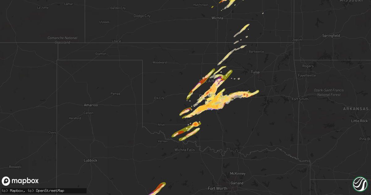
Hail Map in Oklahoma on April 19, 2023
Get this storm
April 19 map
$229
one time, instant access
Download today. No call, no setup
Keep the $229
Bought the map and want the full workflow? Apply the entire $229 to a subscription within 7 days. None of it is wasted.
Every map, not just this one
This buys you this map. Subscription and you get every map we run, in the markets you choose from a few cities to whole states to nationwide. Plus real-time alerts the moment a storm fires.
Contact data
Name, contact info, occupancy, even credit band for addresses in the footprint. You go from where it hit to who to call.
Become the source they trust
Unlimited branding weather history reports on demand. You already have the documented answer ready for the property owner, and you are the one who showed up with it.
Property data and RoofTrace estimates
Pull up any address you have got, its value and the exact code rules for that jurisdiction, straight from One Click Code. Then RoofTrace estimates the squares, pitch, and roof value, priced the way you price.
Storm reports in Oklahoma
Oklahoma
| Date | Description |
|---|---|
| 04/19/20236:55 PM CDT | A local report indicates 1.00 inch wind near KINGFISHER |
| 04/19/20236:33 PM CDT | Report from mping: tea cup |
| 04/19/20236:30 PM CDT | A local report indicates 2.00 inch wind near 4 W EDMOND |
| 04/19/20236:22 PM CDT | Report from mping: half dollar |
| 04/19/20236:16 PM CDT | Report from mping: half dollar |
| 04/19/20236:15 PM CDT | A local report indicates 1.75 inch wind near 2 WNW THE VILLAGE |
| 04/19/20236:15 PM CDT | A local report indicates 1.25 inch wind near 4 NNW WARR ACRES |
| 04/19/20236:14 PM CDT | Report from mping: tennis ball |
| 04/19/20236:14 PM CDT | A local report indicates 1.50 inch wind near 5 S MOORE |
| 04/19/20236:14 PM CDT | Report from mping: golf ball |
| 04/19/20236:13 PM CDT | Report from mping: golf ball |
| 04/19/20236:09 PM CDT | Report from mping: ping pong ball |
| 04/19/20236:09 PM CDT | Report from mping: quarter |
| 04/19/20236:05 PM CDT | A local report indicates 1.75 inch wind near 1 ENE YUKON |
| 04/19/20236:05 PM CDT | Report received via social media. Time estimated via radar. |
| 04/19/20236:01 PM CDT | Report from mping: hen egg+ |
| 04/19/20236:01 PM CDT | A local report indicates 2.00 inch wind near 4 N THE VILLAGE |
| 04/19/20236:00 PM CDT | A local report indicates 1.50 inch wind near 1 N NEWCASTLE |
| 04/19/20235:59 PM CDT | Report from mping: half dollar |
| 04/19/20235:59 PM CDT | Report from mping: golf ball |
| 04/19/20235:58 PM CDT | Report from mping: tennis ball |
| 04/19/20235:55 PM CDT | A local report indicates 1.75 inch wind near 1 NW EDMOND |
| 04/19/20235:55 PM CDT | A local report indicates 1.75 inch wind near 1 WSW NEWCASTLE |
| 04/19/20235:55 PM CDT | Report from mping: hen egg |
| 04/19/20235:54 PM CDT | Report from mping: quarter |
| 04/19/20235:52 PM CDT | A local report indicates 2.25 inch wind near BRIDGE CREEK |
| 04/19/20235:50 PM CDT | A local report indicates 1.75 inch wind near 1 ENE BLANCHARD |
| 04/19/20235:50 PM CDT | Report from mping: hen egg |
| 04/19/20235:49 PM CDT | A local report indicates 1.50 inch wind near 4 N THE VILLAGE |
| 04/19/20235:49 PM CDT | A local report indicates 1.50 inch wind near 3 N THE VILLAGE |
| 04/19/20235:47 PM CDT | A local report indicates 2.00 inch wind near 2 NE BLANCHARD |
| 04/19/20235:46 PM CDT | Report from mping: baseball |
| 04/19/20235:45 PM CDT | A local report indicates 1.00 inch wind near 1 SE NICHOLS HILLS |
| 04/19/20235:45 PM CDT | Report from mping: half dollar |
| 04/19/20235:41 PM CDT | A local report indicates 1.00 inch wind near BLANCHARD |
| 04/19/20235:40 PM CDT | A local report indicates 1.00 inch wind near MUSTANG |
| 04/19/20235:39 PM CDT | A local report indicates 1.00 inch wind near MUSTANG |
| 04/19/20235:37 PM CDT | A local report indicates 1.00 inch wind near WILL ROGERS WORLD AIRPO |
| 04/19/20235:37 PM CDT | Report from mping: quarter |
| 04/19/20235:31 PM CDT | A local report indicates 1.00 inch wind near 6 WSW VALLEY BROOK |
| 04/19/20235:20 PM CDT | Report from mping: half dollar |
| 04/19/20235:18 PM CDT | A local report indicates 1.75 inch wind near CHICKASHA |
| 04/19/20235:08 PM CDT | Report from mping: quarter |
| 04/19/20235:07 PM CDT | A local report indicates 1.25 inch wind near 1 NE CHICKASHA |
| 04/19/20235:06 PM CDT | A local report indicates 1.25 inch wind near CHICKASHA |
| 04/19/20235:04 PM CDT | A local report indicates 1.00 inch wind near CHICKASHA |
| 04/19/202312:15 AM CDT | Report from mping: quarter |
| 04/18/202311:40 PM CDT | A local report indicates 3.75 inch wind near OKEMAH |
| 04/18/202311:30 PM CDT | A local report indicates 4.00 inch wind near 5 SE MASON |
| 04/18/202311:00 PM CDT | A local report indicates 1.75 inch wind near PADEN |
| 04/18/202310:03 PM CDT | Report from mping: quarter |
| 04/18/202310:00 PM CDT | A local report indicates 84 MPH wind near 3 NNW SHAWNEE |
| 04/18/20239:59 PM CDT | Damage reported in shawnee including at oklahoma baptist university and areas near i-40 and kickapoo road. The tornado likely began northwest of tecumseh around 941 pm |
| 04/18/20239:39 PM CDT | Report from mping: quarter |
| 04/18/20239:23 PM CDT | A local report indicates a tornado near 2 N BETHEL ACRES |
| 04/18/20239:16 PM CDT | Tornado debris signature evident on radar. Moved north-northwest to east of stella. |
| 04/18/20239:04 PM CDT | A local report indicates a tornado near 2 SSE PINK |
| 04/18/20239:00 PM CDT | Report from mping: hen egg |
| 04/18/20238:54 PM CDT | Report from mping: hen egg+ |
| 04/18/20238:48 PM CDT | The tornado moved northeast through 859 pm into pottawtomie county. |
| 04/18/20238:45 PM CDT | Report from mping: hen egg |
| 04/18/20238:38 PM CDT | A local report indicates a tornado near 3 W ETOWAH |
| 04/18/20238:24 PM CDT | A local report indicates 2.50 inch wind near 6 S STERLING |
| 04/18/20238:22 PM CDT | Report from mping: hen egg |
| 04/18/20238:20 PM CDT | Time estimated via radar. |
| 04/18/20238:20 PM CDT | A local report indicates 1.25 inch wind near 3 SE NORMAN |
| 04/18/20238:18 PM CDT | A local report indicates 1.75 inch wind near 4 W CENTRAL HIGH |
| 04/18/20238:15 PM CDT | A local report indicates 1.25 inch wind near 4 W VALLEY BROOK |
| 04/18/20238:11 PM CDT | A local report indicates 2.00 inch wind near 2 E NOBLE |
| 04/18/20238:10 PM CDT | Time estimated via radar. |
| 04/18/20238:04 PM CDT | Will rogers world airport. |
| 04/18/20237:33 PM CDT | A local report indicates a tornado near COLE |
| 04/18/20237:25 PM CDT | Report from mping: ping pong ball |
| 04/18/20237:25 PM CDT | Part of roof removed along with some vinyl siding. Also fence damage. |
| 04/18/20237:23 PM CDT | A local report indicates 2.50 inch wind near 1 SW BLANCHARD |
| 04/18/20237:18 PM CDT | A local report indicates 2.75 inch wind near TABLER |
| 04/18/20237:12 PM CDT | A local report indicates 2.00 inch wind near 1 E MIDWEST CITY |
| 04/18/20237:03 PM CDT | Tornado observed west of stanley draper lake moving northeast toward tinker afb. |
| 04/18/20237:00 PM CDT | Relayed by em. |
All States Impacted by Hail Map on April 19, 2023
Cities Impacted by Hail Map on April 19, 2023
- Fort Dodge, IA
- Badger, IA
- Vincent, IA
- Thor, IA
- Humboldt, IA
- Eagle Grove, IA
- Norway, IA
- Fairfax, IA
- Marion, IA
- Cedar Rapids, IA
- Hopkinton, IA
- Anamosa, IA
- Monticello, IA
- Cascade, IA
- Bernard, IA
- Dane, WI
- Lodi, WI
- Arlington, WI
- Mount Horeb, WI
- Cross Plains, WI
- Verona, WI
- Middleton, WI
- Waunakee, WI
- Mazomanie, WI
- Black Earth, WI
- Zwingle, IA
- Dubuque, IA
- East Dubuque, IL
- Peosta, IA
- La Motte, IA
- Bellevue, IA
- Galena, IL
- Hazel Green, WI
- Yates City, IL
- Williamsfield, IL
- Elmwood, IL
- Laura, IL
- Brimfield, IL
- Shullsburg, WI
- Scales Mound, IL
- Benton, WI
- Cuba City, WI
- Cuba, IL
- Smithfield, IL
- Canton, IL
- Glasford, IL
- Farmington, IL
- Trivoli, IL
- Windsor, WI
- Deforest, WI
- Avon, IL
- Ellisville, IL
- Marietta, IL
- Maquon, IL
- London Mills, IL
- Lewistown, IL
- Ipava, IL
- Saint Augustine, IL
- Bushnell, IL
- Macomb, IL
- Dyersville, IA
- New Vienna, IA
- Earlville, IA
- Fairview, IL
- Gilson, IL
- Blue Mounds, WI
- Hanna City, IL
- Baraboo, WI
- Portage, WI
- Poynette, WI
- Oregon, WI
- Stoughton, WI
- Rio, WI
- Watertown, WI
- Johnson Creek, WI
- Jefferson, WI
- Lake Mills, WI
- Cambridge, WI
- Fort Atkinson, WI
- Sheffield, IL
- Neponset, IL
- Wyanet, IL
- Princeton, IL
- Beaver Dam, WI
- Buda, IL
- Hartford, WI
- Slinger, WI
- Ohio, IL
- Malden, IL
- La Moille, IL
- West Bend, WI
- Arlington, IL
- Mendota, IL
- Richfield, WI
- Jackson, WI
- Cedarburg, WI
- Grafton, WI
- Saukville, WI
- Amboy, IL
- Sublette, IL
- West Brooklyn, IL
- Compton, IL
- Earlville, IL
- Heyworth, IL
- Downs, IL
- Le Roy, IL
- Arrowsmith, IL
- Paw Paw, IL
- Steward, IL
- Shabbona, IL
- Leland, IL
- Sheridan, IL
- Chickasha, OK
- Cement, OK
- Somonauk, IL
- Ninnekah, OK
- Bellflower, IL
- Sandwich, IL
- Amber, OK
- Apache, OK
- Newark, IL
- Millington, IL
- Plano, IL
- Yorkville, IL
- Millbrook, IL
- Tuttle, OK
- Cyril, OK
- Fletcher, OK
- Union, NE
- Nebraska City, NE
- Oconomowoc, WI
- Rubicon, WI
- Thurman, IA
- Hubertus, WI
- Oklahoma City, OK
- Newcastle, OK
- Mustang, OK
- McLean, IL
- Ashton, IL
- Armington, IL
- Minier, IL
- Madison, WI
- Waterloo, WI
- Columbus, WI
- Hartland, WI
- Neosho, WI
- Sun Prairie, WI
- Reeseville, WI
- Kewaskum, WI
- Fredonia, WI
- Dekalb, IL
- Sycamore, IL
- Clare, IL
- Trent, SD
- Theresa, WI
- Mayville, WI
- Allenton, WI
- Kirkland, IL
- Malta, IL
- Rochelle, IL
- Esmond, IL
- Prairie Du Sac, WI
- Kewanee, IL
- Ixonia, WI
- Randolph, WI
- Cambria, WI
- Fall River, WI
- Juneau, WI
- Mineral, IL
- Shirley, IL
- Doylestown, WI
- Germantown, WI
- Elgin, OK
- Franklin Grove, IL
- Waterman, IL
- Ashippun, WI
- Mequon, WI
- Hustisford, WI
- Gratiot, WI
- Darlington, WI
- Lowell, WI
- Harmon, IL
- Lee, IL
- Dixon, IL
- Walnut, IL
- Rock Falls, IL
- Dover, IL
- Deer Grove, IL
- Plattsmouth, NE
- Pacific Junction, IA
- Anadarko, OK
- Carnegie, OK
- Mountain View, OK
- Herman, NE
- Hooper, NE
- Winslow, NE
- Wheatland, OK
- Craig, NE
- Humboldt, NE
- Blanchard, OK
- Minooka, IL
- Fort Cobb, OK
- Glenwood, IA
- Tabor, IA
- Malvern, IA
- Edmond, OK
- Jones, OK
- Joliet, IL
- Shorewood, IL
- Plainfield, IL
- Arcadia, OK
- Percival, IA
- Washington, OK
- Norman, OK
- Channahon, IL
- Tekamah, NE
- Minco, OK
- Blencoe, IA
- Decatur, NE
- Union City, OK
- Yukon, OK
- El Reno, OK
- Onawa, IA
- Auburn, NE
- Stella, NE
- Verden, OK
- Brock, NE
- Peru, NE
- Julian, NE
- Rock Port, MO
- Hamburg, IA
- Sidney, IA
- Brownville, NE
- Bethany, OK
- Piedmont, OK
- Silver City, IA
- Halstead, KS
- Mineola, IA
- Durham, KS
- Hinton, OK
- Lookeba, OK
- Calumet, OK
- Geary, OK
- Tampa, KS
- Hastings, IA
- Emerson, IA
- Henderson, IA
- Ramona, KS
- Elwood, IL
- Luther, OK
- Perkins, OK
- Wellston, OK
- Meridian, OK
- Guthrie, OK
- Carney, OK
- Coyle, OK
- Wilmington, IL
- Manhattan, IL
- Soldier, IA
- Castana, IA
- Moorhead, IA
- Johnson, NE
- Baileyville, KS
- Home, KS
- Beattie, KS
- Gracemont, OK
- Okarche, OK
- Kingfisher, OK
- Blue Rapids, KS
- Falls City, NE
- Axtell, KS
- Sabetha, KS
- Seneca, KS
- Craig, MO
- Frankfort, KS
- Bern, KS
- Salem, NE
- Table Rock, NE
- Pawnee City, NE
- Stillwater, OK
- Ripley, OK
- Glencoe, OK
- Chapman, KS
- Junction City, KS
- Yale, OK
- Milford, KS
- Fort Riley, KS
- Watson, MO
- Riley, KS
- Pocasset, OK
- Randolph, IA
- Riverton, IA
- Farragut, IA
- Imogene, IA
- Red Oak, IA
- Peabody, KS
- Minden, IA
- Underwood, IA
- Neola, IA
- Davidson, OK
- Frederick, OK
- Hancock, IA
- Loveland, OK
- Hollister, OK
- Avoca, IA
- Shelby, IA
- Chattanooga, OK
- Walters, OK
- Marion, KS
- Florence, KS
- Choctaw, OK
- Persia, IA
- Harlan, IA
- Portsmouth, IA
- Manhattan, KS
- Leonardville, KS
- Macedonia, IA
- Carson, IA
- Griswold, IA
- Pawnee, OK
- Randolph, KS
- Olsburg, KS
- Westmoreland, KS
- Onaga, KS
- Charter Oak, IA
- Mapleton, IA
- Ute, IA
- Walton, KS
- Ricketts, IA
- Cedar Point, KS
- Vermillion, KS
- Allen, NE
- Waterbury, NE
- Jackson, NE
- Ponca, NE
- Elliott, IA
- Oakland, IA
- Walnut, IA
- Lewis, IA
- Atlantic, IA
- Centralia, KS
- Talmage, NE
- Schleswig, IA
- Denison, IA
- Ida Grove, IA
- Newalla, OK
- Spencer, OK
- Harrah, OK
- Purcell, OK
- Noble, OK
- Lexington, OK
- Du Bois, NE
- Elmdale, KS
- Strong City, KS
- Elk Point, SD
- Jefferson, SD
- Kiron, IA
- Deloit, IA
- Arthur, IA
- Odebolt, IA
- Merkel, TX
- Tuscola, TX
- Abilene, TX
- Dyess Afb, TX
- Tye, TX
- Cleghorn, IA
- Marcus, IA
- Paullina, IA
- Meriden, IA
- Hennessey, OK
- Marshall, OK
- Crescent, OK
- Orlando, OK
- Covington, OK
- Perry, OK
- Lucien, OK
- Mulhall, OK
- Cottonwood Falls, KS
- Morrison, OK
- Tecumseh, OK
- Faxon, OK
- Geronimo, OK
- Lawton, OK
- Cache, OK
- Emporia, KS
- Grandfield, OK
- Devol, OK
- Randlett, OK
- Temple, OK
- Marlow, OK
- Duncan, OK
- Hinton, IA
- Merrill, IA
- Le Mars, IA
- Comanche, OK
- Dakota City, NE
- South Sioux City, NE
- North Sioux City, SD
- Sioux City, IA
- Americus, KS
- Lake View, IA
- Wall Lake, IA
- Vail, IA
- Breda, IA
- Early, IA
- Sac City, IA
- Fonda, IA
- Nehawka, NE
- Murray, NE
- Mcloud, OK
- Allen, KS
- Shawnee, OK
- Moline, KS
- Grenola, KS
- Howard, KS
- Rock Valley, IA
- Sioux Center, IA
- Doon, IA
- Hull, IA
- Macomb, OK
- Admire, KS
- Meeker, OK
- Prague, OK
- Clyde, TX
- Dallas Center, IA
- Woodward, IA
- Granger, IA
- Madrid, IA
- Polk City, IA
- Brayton, IA
- Lawton, IA
- Sergeant Bluff, IA
- Dawson, NE
- Pipestone, MN
- Holland, MN
- Saint George, KS
- Westfield, IA
- Akron, IA
- Flandreau, SD
- Clarinda, IA
- Steinauer, NE
- Elk Creek, NE
- Grant Park, IL
- Milwaukee, WI
- Bourbonnais, IL
- Manteno, IL
- Crest Hill, IL
- Council Grove, KS
- Sussex, WI
- Colgate, WI
- Menomonee Falls, WI
- Milton, WI
- Edgerton, WI
- Janesville, WI
- Evansville, WI
- Hubbard, NE
- Red Rock, OK
- Marland, OK
- Ponca City, OK
- Shidler, OK
- Burbank, OK
- Council Bluffs, IA
- Salix, IA
- Bolingbrook, IL
- Naperville, IL
- Villisca, IA
- Dunbar, NE
- Wilsey, KS
- Alma, KS
- Oswego, IL
- Cedar Vale, KS
- Kankakee, IL
- Albany, TX
- Berryton, KS
- Tecumseh, KS
- Correctionville, IA
- Pierson, IA
- Kingsley, IA
- Burlingame, KS
- Wakarusa, KS
- Topeka, KS
- Auburn, KS
- Carbondale, KS
- Harveyville, KS
- Nickerson, NE
- Momence, IL
- Treynor, IA
- Balaton, MN
- Little Sioux, IA
- Alta Vista, KS
- Dwight, KS
- Alvord, IA
- Inwood, IA
- Lehigh, KS
- White City, KS
- Maple Park, IL
- Summerfield, KS
- Delia, KS
- Eldena, IL
- Belleville, WI
- Lockport, IL
- New Lenox, IL
- Aurora, IL
- Sugar Grove, IL
- Bristol, IL
- Montgomery, IL
- Romeoville, IL
- New Glarus, WI
- Albany, WI
- Monticello, WI
- Wamego, KS
- Otoe, NE
- Avoca, NE
- Syracuse, NE
- Anthon, IA
- Burchard, NE
- Cook, NE
- Tecumseh, NE
- Hillsboro, KS
- Herington, KS
- Brooklyn, WI
- Eskridge, KS
- Lecompton, KS
- Reading, KS
- Nemaha, NE
- Marysville, KS
- Waterville, KS
- Farmer City, IL
- Slater, IA
- Hinckley, IL
- Sheldahl, IA
- Huxley, IA
- Cambridge, IA
- Kelley, IA
- Elkhart, IA
- Ames, IA
- Sparks, OK
- Paden, OK
- Nevada, IA
- Maxwell, IA
- Mount Ayr, IA
- Colo, IA
- Collins, IA
- Zearing, IA
- Indianola, IA
- State Center, IA
- Lawrence, KS
- Perry, KS
- McLouth, KS
- Oskaloosa, KS
- Tonganoxie, KS
- Saint Anthony, IA
- Basehor, KS
- Leavenworth, KS
- Rhodes, IA
- Melbourne, IA
- Boley, OK
- Castle, OK
- Marshalltown, IA
- Okemah, OK
- Okmulgee, OK
- Weleetka, OK
- Henryetta, OK
- Morris, OK
- Downs, KS
- Esbon, KS
- Gaylord, KS
- Paradise, KS
- Waldo, KS
- Natoma, KS
- Osborne, KS
- Lucas, KS
- Luray, KS
- Burns, KS
- Sylvan Grove, KS
- Hunter, KS
- Tipton, KS
- Mankato, KS
- Lebanon, KS
- Wymore, NE
- Liberty, NE
- Blue Springs, NE
- Jewell, KS
- Beloit, KS
- Crab Orchard, NE
- Virginia, NE
- Lewiston, NE
- Sutton, NE
- Grafton, NE
- Geneva, NE
- Formoso, KS
- Courtland, KS
- Webber, KS
- Delphos, KS
- Minneapolis, KS
- Miltonvale, KS
- Aurora, KS
- Ellsworth, KS
- Kanopolis, KS
- Claflin, KS
- Bushton, KS
- Ellinwood, KS
- Fairmont, NE
- Exeter, NE
- Geneseo, KS
- Lorraine, KS
- Brookville, KS
- Superior, NE
- Clay Center, KS
- Morganville, KS
- Salina, KS
- Green, KS
- Greenleaf, KS
- Barnes, KS
- Wakefield, KS
- Meriden, KS
- Valley Falls, KS
- Ozawkie, KS
- Ottawa, KS
- George, IA
- Rock Rapids, IA
- Lytton, IA
- Hardy, NE
- Yates Center, KS
- Jolley, IA
- Johnston, IA
- Horicon, WI
- Iron Ridge, WI
- Gladbrook, IA
- Toledo, IA
- Garwin, IA
- Traer, IA
- Cherokee, IA
- Prole, IA
- Saint Marys, IA
- Saint Charles, IA
- New Virginia, IA
- Polo, MO
- Redfield, IA
- Dexter, IA
- Earlham, IA
- Weeping Water, NE
- Sutherland, IA
- Larrabee, IA
- Remsen, IA
- Calumet, IA
- Waukee, IA
- Clive, IA
- Sedan, KS
- Savannah, MO
- Cosby, MO
- Saint Joseph, MO
- Pawhuska, OK
- Amazonia, MO
- Oregon, MO
- Wathena, KS
- Troy, KS
- Whitewater, KS
- Boyden, IA
- Stuart, IA
- Belleville, KS
- Republic, KS
- Robinson, KS
- Havensville, KS
- Cambridge, KS
- Dexter, KS
- Matfield Green, KS
- Lebo, KS
- Burr Oak, KS
- Menlo, IA
- Kansas City, KS
- Saint Marys, KS
- Emmett, KS
- Byron, NE
- Chester, NE
- Shenandoah, IA
- Essex, IA
- Clyde, KS
- Clifton, KS
- Palmer, KS
- Woodbine, KS
- Greenfield, IA
- Alton, KS
- Plainville, KS
- Moville, IA
- Neosho Rapids, KS
- Baird, TX
- Barnard, MO
- Graham, MO
- Skidmore, MO
- Burdick, KS
- Wilson, KS
- Holyrood, KS
- Lincoln, KS
- Holstein, IA
- Cushing, IA
- Washta, IA
- Ellsworth, MN
- Hawarden, IA
- Magnolia, MN
- Bondurant, IA
- Minburn, IA
- Clemons, IA
- Adel, IA
- Alleman, IA
- Grimes, IA
- Albion, IA
- Ankeny, IA
- Prairie City, IA
- Hamilton, MO
- Valley Center, KS
- Beverly, KS
- Horton, KS
- Whiting, KS
- Cowgill, MO
- Kingston, MO
- Oneida, KS
- Potwin, KS
- Orient, IA
- Bronson, IA
- Madison, KS
- Kansas City, MO
- Waldron, MO
- Platte City, MO
- Lansing, KS
- Northboro, IA
- Coin, IA
- Olpe, KS
- Silver Lake, KS
- Quimby, IA
- Aurelia, IA
- Scranton, KS
- Fairfax, MO
- Barnard, KS
- Smith Center, KS
- Elk Falls, KS
- Abilene, KS
- Sterling, NE
- Lorton, NE
- McClelland, IA
- Longford, KS
- Tescott, KS
- Hartford, KS
- Earlsboro, OK
- Wellsville, KS
- Baldwin City, KS
- Edgerton, KS
- Eudora, KS
- Gardner, KS
- Nortonville, KS
- Linwood, KS
- Goff, KS
- Corning, KS
- Fairview, KS
- Morrill, KS
- Hiawatha, KS
- South Wayne, WI
- Melvern, KS
- Baldwin, IA
- Monmouth, IA
- Hanover, KS
- Whitewater, WI
- Maple Hill, KS
- Olin, IA
- Paxico, KS
- Deerfield, WI
- Marshall, WI
- Pardeeville, WI
- Monroe, WI
- Onslow, IA
- Wyoming, IA
- Great Bend, KS
- Olmitz, KS
- Hoisington, KS
- Clarence, IA
- Oxford Junction, IA
- Stanford, IL
- Soldier, KS
- Bonfield, IL
- Belvue, KS
- Westphalia, KS
- Miles, IA
- Hanover, IL
- Savanna, IL
- Platteville, WI
- Richmond, KS
- Pomona, KS
- Williamsburg, KS
- Quenemo, KS
- Highland, KS
- Mayetta, KS
- Princeton, KS
- Drumright, OK
- Belton, MO
- Stilwell, KS
- Grandview, MO
- Louisburg, KS
- Bucyrus, KS
- Paola, KS
- Spring Hill, KS
- Dover, OK
- Stanton, IA
- Cumberland, IA
- Enterprise, KS
- Boone, IA
- Epworth, IA
- Clinton, IL
- Oketo, KS
- Vassar, KS
- Lyndon, KS
- Overbrook, KS
- Concordia, KS
- Cushing, OK
- Lane, KS
- Rantoul, KS
- Osawatomie, KS
- Marengo, IA
- Hawley, TX
- Burnett, WI
- Ottawa, IL
- Preston, IA
- Story City, IA
- Elburn, IL
- Salisbury, MO
- Binger, OK
- Serena, IL
- Argyle, WI
- Elkhorn, WI
- East Troy, WI
- Eagle, WI
- Mukwonago, WI
- Kingston, IL
- Morris, IL
- Glasgow, MO
- Keytesville, MO
- Peotone, IL
- Cottage Grove, WI
- Fredericksburg, TX
- Harper, TX


