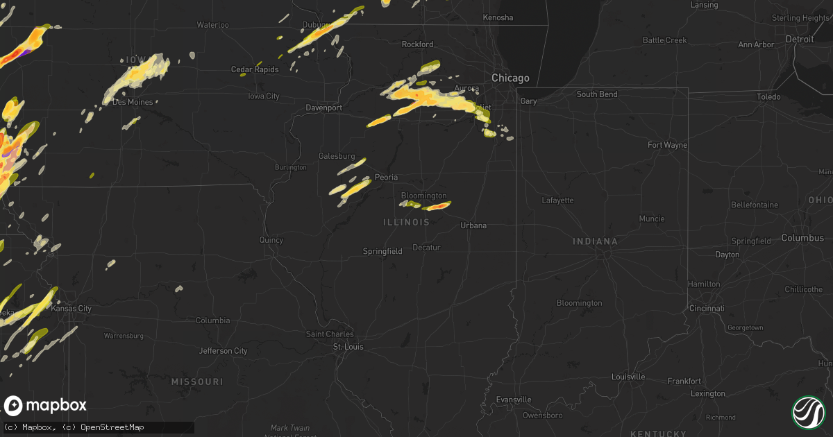
Hail Map in Illinois on April 19, 2023
Get this storm
April 19 map
$229
one time, instant access
Download today. No call, no setup
Keep the $229
Bought the map and want the full workflow? Apply the entire $229 to a subscription within 7 days. None of it is wasted.
Every map, not just this one
This buys you this map. Subscription and you get every map we run, in the markets you choose from a few cities to whole states to nationwide. Plus real-time alerts the moment a storm fires.
Contact data
Name, contact info, occupancy, even credit band for addresses in the footprint. You go from where it hit to who to call.
Become the source they trust
Unlimited branding weather history reports on demand. You already have the documented answer ready for the property owner, and you are the one who showed up with it.
Property data and RoofTrace estimates
Pull up any address you have got, its value and the exact code rules for that jurisdiction, straight from One Click Code. Then RoofTrace estimates the squares, pitch, and roof value, priced the way you price.
Storm reports in Illinois
Illinois
| Date | Description |
|---|---|
| 04/19/20235:55 PM CDT | Quarter sized hail reported at joliet junior college. |
| 04/19/20235:53 PM CDT | A local report indicates 1.00 inch wind near 1 WNW SHOREWOOD |
| 04/19/20235:49 PM CDT | Multiple reports of quarter sized hail in west shorewood relayed via mping. |
| 04/19/20235:44 PM CDT | Trained spotter reports quarter sized hail near ridge road and holt road north of minooka. |
| 04/19/20235:40 PM CDT | Relayed via mping. |
| 04/19/20235:40 PM CDT | Trained spotter reports half dollar sized hail near caton farm road and county line road in west joliet. |
| 04/19/20235:37 PM CDT | Trained spotter reports golf ball sized hail in west joliet. |
| 04/19/20235:26 PM CDT | Relayed via mping. |
| 04/19/20235:16 PM CDT | Dime to quarter sized hail near us34 and game farm road in yorkville. Time estimated by radar. |
| 04/19/20235:14 PM CDT | Trained spotter reports quarter sized hail near il71 and il47 in south yorkville. |
| 04/19/20234:46 PM CDT | Relayed via mping. |
| 04/19/20234:36 PM CDT | Relayed via broadcast media. |
| 04/19/20234:35 PM CDT | Photo shared via social media shows half dollar sized hail northeast of earlville. Time estimated by radar. |
| 04/19/20234:25 PM CDT | Trained spotter reports hail up to quarter sized southwest of steward near il251 and herman road. |
| 04/19/20234:20 PM CDT | Relayed via social media. Several small hailstones with a few 1 inch stones mixed it. |
| 04/19/20234:17 PM CDT | Photo relayed via social media of ping pong to golf ball size hail. |
| 04/19/20234:17 PM CDT | Delayed report. Photo relayed via broadcast media. Time estimated from radar. |
| 04/19/20234:17 PM CDT | Photo relayed via social media of golf ball size hail. |
| 04/19/20234:10 PM CDT | Photo relayed via social media. |
| 04/19/20234:03 PM CDT | Hail at least quarter sized reported in sublette. |
| 04/19/20233:58 PM CDT | Photo shared via social media shows hail of at least golf ball size north of earlville. Time estimated by radar... Location approximate. |
| 04/19/20233:54 PM CDT | Corrects previous hail report from 3 wnw sublette. Trained spotter reports quarter sized hail at woodhaven lakes. Time estimated by radar. |
| 04/19/20233:52 PM CDT | Social media pictures showed hail approximately quarter sized. Time estimated by radar. |
| 04/19/20233:48 PM CDT | Relayed via broadcast media. |
| 04/19/20233:44 PM CDT | Photo shows golf ball sized hail near meridan. Time estimated by radar. |
| 04/19/20233:42 PM CDT | Broken windshield from hail near i-39 mile marker 74 northeast of mendota. Hail size estimated. Time estimated by radar. |
| 04/19/20233:34 PM CDT | Photo shows 2 inch diameter hail near 46th road and il251. Time estimated by radar. |
| 04/19/20233:34 PM CDT | Photo shows quarter size hail in mendota near strobe avenue and 14th street. Time estimated by radar. |
| 04/19/20233:20 PM CDT | Picture sent to facebook. Time estimated from radar. |
| 04/19/20233:10 PM CDT | Photos of several quarter size hail stones. |
| 04/19/20232:56 PM CDT | A local report indicates 1.00 inch wind near 4 W DOVER |
| 04/19/20232:35 PM CDT | A local report indicates 1.75 inch wind near 1 NNE WYANET |
| 04/19/20232:28 PM CDT | A local report indicates 1.50 inch wind near 1 ESE SHEFFIELD |
| 04/19/20232:28 PM CDT | Public photo from mm43 of ping pong sized hail. |
| 04/19/20232:15 PM CDT | Relayed by broadcast media. |
| 04/19/20232:15 PM CDT | Relayed by broadcast media. |
| 04/19/202312:30 PM CDT | Pea to dime size hail with a few hailstones the size of quarters reported on twitter with photo. |
| 04/19/202312:25 PM CDT | Quarter to ping pong size hail at wee-ma-tuk reported on facebook with photo. |
| 04/19/202312:15 PM CDT | Emergency manager relayed report from social media of quarter to half dollar size hail in cuba. |
| 04/19/202311:54 AM CDT | A local report indicates 1.00 inch wind near 4 NW GALENA |
| 04/19/202311:36 AM CDT | A local report indicates 1.00 inch wind near EAST DUBUQUE |
| 04/18/20237:04 PM CDT | Photos and video shared to social media show quarter sized hail near 9000 north road and 3500 west road west of manteno. Time estimated by radar. |
| 04/18/20237:02 PM CDT | A local report indicates 1.25 inch wind near 3 NE BONFIELD |
All States Impacted by Hail Map on April 19, 2023
Cities Impacted by Hail Map on April 19, 2023
- Fort Dodge, IA
- Badger, IA
- Vincent, IA
- Thor, IA
- Humboldt, IA
- Eagle Grove, IA
- Norway, IA
- Fairfax, IA
- Marion, IA
- Cedar Rapids, IA
- Hopkinton, IA
- Anamosa, IA
- Monticello, IA
- Cascade, IA
- Bernard, IA
- Dane, WI
- Lodi, WI
- Arlington, WI
- Mount Horeb, WI
- Cross Plains, WI
- Verona, WI
- Middleton, WI
- Waunakee, WI
- Mazomanie, WI
- Black Earth, WI
- Zwingle, IA
- Dubuque, IA
- East Dubuque, IL
- Peosta, IA
- La Motte, IA
- Bellevue, IA
- Galena, IL
- Hazel Green, WI
- Yates City, IL
- Williamsfield, IL
- Elmwood, IL
- Laura, IL
- Brimfield, IL
- Shullsburg, WI
- Scales Mound, IL
- Benton, WI
- Cuba City, WI
- Cuba, IL
- Smithfield, IL
- Canton, IL
- Glasford, IL
- Farmington, IL
- Trivoli, IL
- Windsor, WI
- Deforest, WI
- Avon, IL
- Ellisville, IL
- Marietta, IL
- Maquon, IL
- London Mills, IL
- Lewistown, IL
- Ipava, IL
- Saint Augustine, IL
- Bushnell, IL
- Macomb, IL
- Dyersville, IA
- New Vienna, IA
- Earlville, IA
- Fairview, IL
- Gilson, IL
- Blue Mounds, WI
- Hanna City, IL
- Baraboo, WI
- Portage, WI
- Poynette, WI
- Oregon, WI
- Stoughton, WI
- Rio, WI
- Watertown, WI
- Johnson Creek, WI
- Jefferson, WI
- Lake Mills, WI
- Cambridge, WI
- Fort Atkinson, WI
- Sheffield, IL
- Neponset, IL
- Wyanet, IL
- Princeton, IL
- Beaver Dam, WI
- Buda, IL
- Hartford, WI
- Slinger, WI
- Ohio, IL
- Malden, IL
- La Moille, IL
- West Bend, WI
- Arlington, IL
- Mendota, IL
- Richfield, WI
- Jackson, WI
- Cedarburg, WI
- Grafton, WI
- Saukville, WI
- Amboy, IL
- Sublette, IL
- West Brooklyn, IL
- Compton, IL
- Earlville, IL
- Heyworth, IL
- Downs, IL
- Le Roy, IL
- Arrowsmith, IL
- Paw Paw, IL
- Steward, IL
- Shabbona, IL
- Leland, IL
- Sheridan, IL
- Chickasha, OK
- Cement, OK
- Somonauk, IL
- Ninnekah, OK
- Bellflower, IL
- Sandwich, IL
- Amber, OK
- Apache, OK
- Newark, IL
- Millington, IL
- Plano, IL
- Yorkville, IL
- Millbrook, IL
- Tuttle, OK
- Cyril, OK
- Fletcher, OK
- Union, NE
- Nebraska City, NE
- Oconomowoc, WI
- Rubicon, WI
- Thurman, IA
- Hubertus, WI
- Oklahoma City, OK
- Newcastle, OK
- Mustang, OK
- McLean, IL
- Ashton, IL
- Armington, IL
- Minier, IL
- Madison, WI
- Waterloo, WI
- Columbus, WI
- Hartland, WI
- Neosho, WI
- Sun Prairie, WI
- Reeseville, WI
- Kewaskum, WI
- Fredonia, WI
- Dekalb, IL
- Sycamore, IL
- Clare, IL
- Trent, SD
- Theresa, WI
- Mayville, WI
- Allenton, WI
- Kirkland, IL
- Malta, IL
- Rochelle, IL
- Esmond, IL
- Prairie Du Sac, WI
- Kewanee, IL
- Ixonia, WI
- Randolph, WI
- Cambria, WI
- Fall River, WI
- Juneau, WI
- Mineral, IL
- Shirley, IL
- Doylestown, WI
- Germantown, WI
- Elgin, OK
- Franklin Grove, IL
- Waterman, IL
- Ashippun, WI
- Mequon, WI
- Hustisford, WI
- Gratiot, WI
- Darlington, WI
- Lowell, WI
- Harmon, IL
- Lee, IL
- Dixon, IL
- Walnut, IL
- Rock Falls, IL
- Dover, IL
- Deer Grove, IL
- Plattsmouth, NE
- Pacific Junction, IA
- Anadarko, OK
- Carnegie, OK
- Mountain View, OK
- Herman, NE
- Hooper, NE
- Winslow, NE
- Wheatland, OK
- Craig, NE
- Humboldt, NE
- Blanchard, OK
- Minooka, IL
- Fort Cobb, OK
- Glenwood, IA
- Tabor, IA
- Malvern, IA
- Edmond, OK
- Jones, OK
- Joliet, IL
- Shorewood, IL
- Plainfield, IL
- Arcadia, OK
- Percival, IA
- Washington, OK
- Norman, OK
- Channahon, IL
- Tekamah, NE
- Minco, OK
- Blencoe, IA
- Decatur, NE
- Union City, OK
- Yukon, OK
- El Reno, OK
- Onawa, IA
- Auburn, NE
- Stella, NE
- Verden, OK
- Brock, NE
- Peru, NE
- Julian, NE
- Rock Port, MO
- Hamburg, IA
- Sidney, IA
- Brownville, NE
- Bethany, OK
- Piedmont, OK
- Silver City, IA
- Halstead, KS
- Mineola, IA
- Durham, KS
- Hinton, OK
- Lookeba, OK
- Calumet, OK
- Geary, OK
- Tampa, KS
- Hastings, IA
- Emerson, IA
- Henderson, IA
- Ramona, KS
- Elwood, IL
- Luther, OK
- Perkins, OK
- Wellston, OK
- Meridian, OK
- Guthrie, OK
- Carney, OK
- Coyle, OK
- Wilmington, IL
- Manhattan, IL
- Soldier, IA
- Castana, IA
- Moorhead, IA
- Johnson, NE
- Baileyville, KS
- Home, KS
- Beattie, KS
- Gracemont, OK
- Okarche, OK
- Kingfisher, OK
- Blue Rapids, KS
- Falls City, NE
- Axtell, KS
- Sabetha, KS
- Seneca, KS
- Craig, MO
- Frankfort, KS
- Bern, KS
- Salem, NE
- Table Rock, NE
- Pawnee City, NE
- Stillwater, OK
- Ripley, OK
- Glencoe, OK
- Chapman, KS
- Junction City, KS
- Yale, OK
- Milford, KS
- Fort Riley, KS
- Watson, MO
- Riley, KS
- Pocasset, OK
- Randolph, IA
- Riverton, IA
- Farragut, IA
- Imogene, IA
- Red Oak, IA
- Peabody, KS
- Minden, IA
- Underwood, IA
- Neola, IA
- Davidson, OK
- Frederick, OK
- Hancock, IA
- Loveland, OK
- Hollister, OK
- Avoca, IA
- Shelby, IA
- Chattanooga, OK
- Walters, OK
- Marion, KS
- Florence, KS
- Choctaw, OK
- Persia, IA
- Harlan, IA
- Portsmouth, IA
- Manhattan, KS
- Leonardville, KS
- Macedonia, IA
- Carson, IA
- Griswold, IA
- Pawnee, OK
- Randolph, KS
- Olsburg, KS
- Westmoreland, KS
- Onaga, KS
- Charter Oak, IA
- Mapleton, IA
- Ute, IA
- Walton, KS
- Ricketts, IA
- Cedar Point, KS
- Vermillion, KS
- Allen, NE
- Waterbury, NE
- Jackson, NE
- Ponca, NE
- Elliott, IA
- Oakland, IA
- Walnut, IA
- Lewis, IA
- Atlantic, IA
- Centralia, KS
- Talmage, NE
- Schleswig, IA
- Denison, IA
- Ida Grove, IA
- Newalla, OK
- Spencer, OK
- Harrah, OK
- Purcell, OK
- Noble, OK
- Lexington, OK
- Du Bois, NE
- Elmdale, KS
- Strong City, KS
- Elk Point, SD
- Jefferson, SD
- Kiron, IA
- Deloit, IA
- Arthur, IA
- Odebolt, IA
- Merkel, TX
- Tuscola, TX
- Abilene, TX
- Dyess Afb, TX
- Tye, TX
- Cleghorn, IA
- Marcus, IA
- Paullina, IA
- Meriden, IA
- Hennessey, OK
- Marshall, OK
- Crescent, OK
- Orlando, OK
- Covington, OK
- Perry, OK
- Lucien, OK
- Mulhall, OK
- Cottonwood Falls, KS
- Morrison, OK
- Tecumseh, OK
- Faxon, OK
- Geronimo, OK
- Lawton, OK
- Cache, OK
- Emporia, KS
- Grandfield, OK
- Devol, OK
- Randlett, OK
- Temple, OK
- Marlow, OK
- Duncan, OK
- Hinton, IA
- Merrill, IA
- Le Mars, IA
- Comanche, OK
- Dakota City, NE
- South Sioux City, NE
- North Sioux City, SD
- Sioux City, IA
- Americus, KS
- Lake View, IA
- Wall Lake, IA
- Vail, IA
- Breda, IA
- Early, IA
- Sac City, IA
- Fonda, IA
- Nehawka, NE
- Murray, NE
- Mcloud, OK
- Allen, KS
- Shawnee, OK
- Moline, KS
- Grenola, KS
- Howard, KS
- Rock Valley, IA
- Sioux Center, IA
- Doon, IA
- Hull, IA
- Macomb, OK
- Admire, KS
- Meeker, OK
- Prague, OK
- Clyde, TX
- Dallas Center, IA
- Woodward, IA
- Granger, IA
- Madrid, IA
- Polk City, IA
- Brayton, IA
- Lawton, IA
- Sergeant Bluff, IA
- Dawson, NE
- Pipestone, MN
- Holland, MN
- Saint George, KS
- Westfield, IA
- Akron, IA
- Flandreau, SD
- Clarinda, IA
- Steinauer, NE
- Elk Creek, NE
- Grant Park, IL
- Milwaukee, WI
- Bourbonnais, IL
- Manteno, IL
- Crest Hill, IL
- Council Grove, KS
- Sussex, WI
- Colgate, WI
- Menomonee Falls, WI
- Milton, WI
- Edgerton, WI
- Janesville, WI
- Evansville, WI
- Hubbard, NE
- Red Rock, OK
- Marland, OK
- Ponca City, OK
- Shidler, OK
- Burbank, OK
- Council Bluffs, IA
- Salix, IA
- Bolingbrook, IL
- Naperville, IL
- Villisca, IA
- Dunbar, NE
- Wilsey, KS
- Alma, KS
- Oswego, IL
- Cedar Vale, KS
- Kankakee, IL
- Albany, TX
- Berryton, KS
- Tecumseh, KS
- Correctionville, IA
- Pierson, IA
- Kingsley, IA
- Burlingame, KS
- Wakarusa, KS
- Topeka, KS
- Auburn, KS
- Carbondale, KS
- Harveyville, KS
- Nickerson, NE
- Momence, IL
- Treynor, IA
- Balaton, MN
- Little Sioux, IA
- Alta Vista, KS
- Dwight, KS
- Alvord, IA
- Inwood, IA
- Lehigh, KS
- White City, KS
- Maple Park, IL
- Summerfield, KS
- Delia, KS
- Eldena, IL
- Belleville, WI
- Lockport, IL
- New Lenox, IL
- Aurora, IL
- Sugar Grove, IL
- Bristol, IL
- Montgomery, IL
- Romeoville, IL
- New Glarus, WI
- Albany, WI
- Monticello, WI
- Wamego, KS
- Otoe, NE
- Avoca, NE
- Syracuse, NE
- Anthon, IA
- Burchard, NE
- Cook, NE
- Tecumseh, NE
- Hillsboro, KS
- Herington, KS
- Brooklyn, WI
- Eskridge, KS
- Lecompton, KS
- Reading, KS
- Nemaha, NE
- Marysville, KS
- Waterville, KS
- Farmer City, IL
- Slater, IA
- Hinckley, IL
- Sheldahl, IA
- Huxley, IA
- Cambridge, IA
- Kelley, IA
- Elkhart, IA
- Ames, IA
- Sparks, OK
- Paden, OK
- Nevada, IA
- Maxwell, IA
- Mount Ayr, IA
- Colo, IA
- Collins, IA
- Zearing, IA
- Indianola, IA
- State Center, IA
- Lawrence, KS
- Perry, KS
- McLouth, KS
- Oskaloosa, KS
- Tonganoxie, KS
- Saint Anthony, IA
- Basehor, KS
- Leavenworth, KS
- Rhodes, IA
- Melbourne, IA
- Boley, OK
- Castle, OK
- Marshalltown, IA
- Okemah, OK
- Okmulgee, OK
- Weleetka, OK
- Henryetta, OK
- Morris, OK
- Downs, KS
- Esbon, KS
- Gaylord, KS
- Paradise, KS
- Waldo, KS
- Natoma, KS
- Osborne, KS
- Lucas, KS
- Luray, KS
- Burns, KS
- Sylvan Grove, KS
- Hunter, KS
- Tipton, KS
- Mankato, KS
- Lebanon, KS
- Wymore, NE
- Liberty, NE
- Blue Springs, NE
- Jewell, KS
- Beloit, KS
- Crab Orchard, NE
- Virginia, NE
- Lewiston, NE
- Sutton, NE
- Grafton, NE
- Geneva, NE
- Formoso, KS
- Courtland, KS
- Webber, KS
- Delphos, KS
- Minneapolis, KS
- Miltonvale, KS
- Aurora, KS
- Ellsworth, KS
- Kanopolis, KS
- Claflin, KS
- Bushton, KS
- Ellinwood, KS
- Fairmont, NE
- Exeter, NE
- Geneseo, KS
- Lorraine, KS
- Brookville, KS
- Superior, NE
- Clay Center, KS
- Morganville, KS
- Salina, KS
- Green, KS
- Greenleaf, KS
- Barnes, KS
- Wakefield, KS
- Meriden, KS
- Valley Falls, KS
- Ozawkie, KS
- Ottawa, KS
- George, IA
- Rock Rapids, IA
- Lytton, IA
- Hardy, NE
- Yates Center, KS
- Jolley, IA
- Johnston, IA
- Horicon, WI
- Iron Ridge, WI
- Gladbrook, IA
- Toledo, IA
- Garwin, IA
- Traer, IA
- Cherokee, IA
- Prole, IA
- Saint Marys, IA
- Saint Charles, IA
- New Virginia, IA
- Polo, MO
- Redfield, IA
- Dexter, IA
- Earlham, IA
- Weeping Water, NE
- Sutherland, IA
- Larrabee, IA
- Remsen, IA
- Calumet, IA
- Waukee, IA
- Clive, IA
- Sedan, KS
- Savannah, MO
- Cosby, MO
- Saint Joseph, MO
- Pawhuska, OK
- Amazonia, MO
- Oregon, MO
- Wathena, KS
- Troy, KS
- Whitewater, KS
- Boyden, IA
- Stuart, IA
- Belleville, KS
- Republic, KS
- Robinson, KS
- Havensville, KS
- Cambridge, KS
- Dexter, KS
- Matfield Green, KS
- Lebo, KS
- Burr Oak, KS
- Menlo, IA
- Kansas City, KS
- Saint Marys, KS
- Emmett, KS
- Byron, NE
- Chester, NE
- Shenandoah, IA
- Essex, IA
- Clyde, KS
- Clifton, KS
- Palmer, KS
- Woodbine, KS
- Greenfield, IA
- Alton, KS
- Plainville, KS
- Moville, IA
- Neosho Rapids, KS
- Baird, TX
- Barnard, MO
- Graham, MO
- Skidmore, MO
- Burdick, KS
- Wilson, KS
- Holyrood, KS
- Lincoln, KS
- Holstein, IA
- Cushing, IA
- Washta, IA
- Ellsworth, MN
- Hawarden, IA
- Magnolia, MN
- Bondurant, IA
- Minburn, IA
- Clemons, IA
- Adel, IA
- Alleman, IA
- Grimes, IA
- Albion, IA
- Ankeny, IA
- Prairie City, IA
- Hamilton, MO
- Valley Center, KS
- Beverly, KS
- Horton, KS
- Whiting, KS
- Cowgill, MO
- Kingston, MO
- Oneida, KS
- Potwin, KS
- Orient, IA
- Bronson, IA
- Madison, KS
- Kansas City, MO
- Waldron, MO
- Platte City, MO
- Lansing, KS
- Northboro, IA
- Coin, IA
- Olpe, KS
- Silver Lake, KS
- Quimby, IA
- Aurelia, IA
- Scranton, KS
- Fairfax, MO
- Barnard, KS
- Smith Center, KS
- Elk Falls, KS
- Abilene, KS
- Sterling, NE
- Lorton, NE
- McClelland, IA
- Longford, KS
- Tescott, KS
- Hartford, KS
- Earlsboro, OK
- Wellsville, KS
- Baldwin City, KS
- Edgerton, KS
- Eudora, KS
- Gardner, KS
- Nortonville, KS
- Linwood, KS
- Goff, KS
- Corning, KS
- Fairview, KS
- Morrill, KS
- Hiawatha, KS
- South Wayne, WI
- Melvern, KS
- Baldwin, IA
- Monmouth, IA
- Hanover, KS
- Whitewater, WI
- Maple Hill, KS
- Olin, IA
- Paxico, KS
- Deerfield, WI
- Marshall, WI
- Pardeeville, WI
- Monroe, WI
- Onslow, IA
- Wyoming, IA
- Great Bend, KS
- Olmitz, KS
- Hoisington, KS
- Clarence, IA
- Oxford Junction, IA
- Stanford, IL
- Soldier, KS
- Bonfield, IL
- Belvue, KS
- Westphalia, KS
- Miles, IA
- Hanover, IL
- Savanna, IL
- Platteville, WI
- Richmond, KS
- Pomona, KS
- Williamsburg, KS
- Quenemo, KS
- Highland, KS
- Mayetta, KS
- Princeton, KS
- Drumright, OK
- Belton, MO
- Stilwell, KS
- Grandview, MO
- Louisburg, KS
- Bucyrus, KS
- Paola, KS
- Spring Hill, KS
- Dover, OK
- Stanton, IA
- Cumberland, IA
- Enterprise, KS
- Boone, IA
- Epworth, IA
- Clinton, IL
- Oketo, KS
- Vassar, KS
- Lyndon, KS
- Overbrook, KS
- Concordia, KS
- Cushing, OK
- Lane, KS
- Rantoul, KS
- Osawatomie, KS
- Marengo, IA
- Hawley, TX
- Burnett, WI
- Ottawa, IL
- Preston, IA
- Story City, IA
- Elburn, IL
- Salisbury, MO
- Binger, OK
- Serena, IL
- Argyle, WI
- Elkhorn, WI
- East Troy, WI
- Eagle, WI
- Mukwonago, WI
- Kingston, IL
- Morris, IL
- Glasgow, MO
- Keytesville, MO
- Peotone, IL
- Cottage Grove, WI
- Fredericksburg, TX
- Harper, TX


