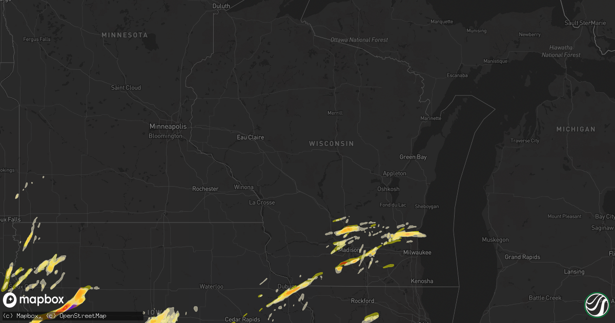
Hail Map in Wisconsin on April 19, 2023
Get this storm
April 19 map
$229
one time, instant access
Download today. No call, no setup
Keep the $229
Bought the map and want the full workflow? Apply the entire $229 to a subscription within 7 days. None of it is wasted.
Every map, not just this one
This buys you this map. Subscription and you get every map we run, in the markets you choose from a few cities to whole states to nationwide. Plus real-time alerts the moment a storm fires.
Contact data
Name, contact info, occupancy, even credit band for addresses in the footprint. You go from where it hit to who to call.
Become the source they trust
Unlimited branding weather history reports on demand. You already have the documented answer ready for the property owner, and you are the one who showed up with it.
Property data and RoofTrace estimates
Pull up any address you have got, its value and the exact code rules for that jurisdiction, straight from One Click Code. Then RoofTrace estimates the squares, pitch, and roof value, priced the way you price.
Storm reports in Wisconsin
Wisconsin
| Date | Description |
|---|---|
| 04/19/20235:15 PM CDT | A local report indicates 1.00 inch wind near 1 E HUBERTUS |
| 04/19/20235:01 PM CDT | A local report indicates 1.00 inch wind near 3 NNE LAC LA BELLE |
| 04/19/20234:57 PM CDT | A local report indicates 1.50 inch wind near 2 N ERIN |
| 04/19/20234:56 PM CDT | A local report indicates 1.00 inch wind near 1 NW IXONIA |
| 04/19/20234:48 PM CDT | A local report indicates 1.25 inch wind near 1 W ERIN |
| 04/19/20233:44 PM CDT | A local report indicates 1.00 inch wind near GRAFTON |
| 04/19/20233:36 PM CDT | Corrects previous hail report from 4 e jackson. |
| 04/19/20233:36 PM CDT | A local report indicates 2.00 inch wind near 4 E JACKSON |
| 04/19/20233:33 PM CDT | A local report indicates 1.75 inch wind near 3 ESE JACKSON |
| 04/19/20233:30 PM CDT | Time estimated from radar. |
| 04/19/20232:39 PM CDT | Report from mping: quarter |
| 04/19/20231:59 PM CDT | A local report indicates 1.50 inch wind near 1 E LAKE RIPLEY |
| 04/19/20231:47 PM CDT | A local report indicates 1.75 inch wind near 2 N POYNETTE |
| 04/19/20231:42 PM CDT | Multiple reports of quarter to half dollar size hail in the stoughton area. |
| 04/19/20231:41 PM CDT | A local report indicates 1.50 inch wind near 3 E LAKE WISCONSIN |
| 04/19/20231:40 PM CDT | Time estimated from radar. |
| 04/19/20231:38 PM CDT | A local report indicates 1.25 inch wind near 2 ESE LAKE WISCONSIN |
| 04/19/20231:37 PM CDT | Time estimated from radar. |
| 04/19/20231:30 PM CDT | Report from mping with additional reports and photos of quarter size hail on social media. |
| 04/19/20231:28 PM CDT | Report from mping: quarter |
| 04/19/20231:24 PM CDT | Time estimated from radar. |
| 04/19/20231:17 PM CDT | Time estimated from radar. |
| 04/19/20231:06 PM CDT | Time estimated from radar. |
| 04/19/202312:28 PM CDT | Time estimated from radar. |
| 04/19/202312:10 PM CDT | Delayed report of half dollar size hail. . |
| 04/19/202312:10 PM CDT | Delayed report of half dollar size hail. |
| 04/19/202312:05 PM CDT | Quarter size hail in many parts of lafayette county... Especially in the benton... Shullsburg and darlington areas. Time estimated from radar for first reports in bento |
| 04/19/202310:54 AM CDT | Report from mping: quarter |
| 04/19/202310:47 AM CDT | Multiple reports of quarter size hail north of middleton. Time radar estimated. |
| 04/19/202310:28 AM CDT | Report from mping: quarter |
| 04/19/202310:20 AM CDT | Report of nickel to quarter size hail via social media. Time radar estimated. |
All States Impacted by Hail Map on April 19, 2023
Cities Impacted by Hail Map on April 19, 2023
- Fort Dodge, IA
- Badger, IA
- Vincent, IA
- Thor, IA
- Humboldt, IA
- Eagle Grove, IA
- Norway, IA
- Fairfax, IA
- Marion, IA
- Cedar Rapids, IA
- Hopkinton, IA
- Anamosa, IA
- Monticello, IA
- Cascade, IA
- Bernard, IA
- Dane, WI
- Lodi, WI
- Arlington, WI
- Mount Horeb, WI
- Cross Plains, WI
- Verona, WI
- Middleton, WI
- Waunakee, WI
- Mazomanie, WI
- Black Earth, WI
- Zwingle, IA
- Dubuque, IA
- East Dubuque, IL
- Peosta, IA
- La Motte, IA
- Bellevue, IA
- Galena, IL
- Hazel Green, WI
- Yates City, IL
- Williamsfield, IL
- Elmwood, IL
- Laura, IL
- Brimfield, IL
- Shullsburg, WI
- Scales Mound, IL
- Benton, WI
- Cuba City, WI
- Cuba, IL
- Smithfield, IL
- Canton, IL
- Glasford, IL
- Farmington, IL
- Trivoli, IL
- Windsor, WI
- Deforest, WI
- Avon, IL
- Ellisville, IL
- Marietta, IL
- Maquon, IL
- London Mills, IL
- Lewistown, IL
- Ipava, IL
- Saint Augustine, IL
- Bushnell, IL
- Macomb, IL
- Dyersville, IA
- New Vienna, IA
- Earlville, IA
- Fairview, IL
- Gilson, IL
- Blue Mounds, WI
- Hanna City, IL
- Baraboo, WI
- Portage, WI
- Poynette, WI
- Oregon, WI
- Stoughton, WI
- Rio, WI
- Watertown, WI
- Johnson Creek, WI
- Jefferson, WI
- Lake Mills, WI
- Cambridge, WI
- Fort Atkinson, WI
- Sheffield, IL
- Neponset, IL
- Wyanet, IL
- Princeton, IL
- Beaver Dam, WI
- Buda, IL
- Hartford, WI
- Slinger, WI
- Ohio, IL
- Malden, IL
- La Moille, IL
- West Bend, WI
- Arlington, IL
- Mendota, IL
- Richfield, WI
- Jackson, WI
- Cedarburg, WI
- Grafton, WI
- Saukville, WI
- Amboy, IL
- Sublette, IL
- West Brooklyn, IL
- Compton, IL
- Earlville, IL
- Heyworth, IL
- Downs, IL
- Le Roy, IL
- Arrowsmith, IL
- Paw Paw, IL
- Steward, IL
- Shabbona, IL
- Leland, IL
- Sheridan, IL
- Chickasha, OK
- Cement, OK
- Somonauk, IL
- Ninnekah, OK
- Bellflower, IL
- Sandwich, IL
- Amber, OK
- Apache, OK
- Newark, IL
- Millington, IL
- Plano, IL
- Yorkville, IL
- Millbrook, IL
- Tuttle, OK
- Cyril, OK
- Fletcher, OK
- Union, NE
- Nebraska City, NE
- Oconomowoc, WI
- Rubicon, WI
- Thurman, IA
- Hubertus, WI
- Oklahoma City, OK
- Newcastle, OK
- Mustang, OK
- McLean, IL
- Ashton, IL
- Armington, IL
- Minier, IL
- Madison, WI
- Waterloo, WI
- Columbus, WI
- Hartland, WI
- Neosho, WI
- Sun Prairie, WI
- Reeseville, WI
- Kewaskum, WI
- Fredonia, WI
- Dekalb, IL
- Sycamore, IL
- Clare, IL
- Trent, SD
- Theresa, WI
- Mayville, WI
- Allenton, WI
- Kirkland, IL
- Malta, IL
- Rochelle, IL
- Esmond, IL
- Prairie Du Sac, WI
- Kewanee, IL
- Ixonia, WI
- Randolph, WI
- Cambria, WI
- Fall River, WI
- Juneau, WI
- Mineral, IL
- Shirley, IL
- Doylestown, WI
- Germantown, WI
- Elgin, OK
- Franklin Grove, IL
- Waterman, IL
- Ashippun, WI
- Mequon, WI
- Hustisford, WI
- Gratiot, WI
- Darlington, WI
- Lowell, WI
- Harmon, IL
- Lee, IL
- Dixon, IL
- Walnut, IL
- Rock Falls, IL
- Dover, IL
- Deer Grove, IL
- Plattsmouth, NE
- Pacific Junction, IA
- Anadarko, OK
- Carnegie, OK
- Mountain View, OK
- Herman, NE
- Hooper, NE
- Winslow, NE
- Wheatland, OK
- Craig, NE
- Humboldt, NE
- Blanchard, OK
- Minooka, IL
- Fort Cobb, OK
- Glenwood, IA
- Tabor, IA
- Malvern, IA
- Edmond, OK
- Jones, OK
- Joliet, IL
- Shorewood, IL
- Plainfield, IL
- Arcadia, OK
- Percival, IA
- Washington, OK
- Norman, OK
- Channahon, IL
- Tekamah, NE
- Minco, OK
- Blencoe, IA
- Decatur, NE
- Union City, OK
- Yukon, OK
- El Reno, OK
- Onawa, IA
- Auburn, NE
- Stella, NE
- Verden, OK
- Brock, NE
- Peru, NE
- Julian, NE
- Rock Port, MO
- Hamburg, IA
- Sidney, IA
- Brownville, NE
- Bethany, OK
- Piedmont, OK
- Silver City, IA
- Halstead, KS
- Mineola, IA
- Durham, KS
- Hinton, OK
- Lookeba, OK
- Calumet, OK
- Geary, OK
- Tampa, KS
- Hastings, IA
- Emerson, IA
- Henderson, IA
- Ramona, KS
- Elwood, IL
- Luther, OK
- Perkins, OK
- Wellston, OK
- Meridian, OK
- Guthrie, OK
- Carney, OK
- Coyle, OK
- Wilmington, IL
- Manhattan, IL
- Soldier, IA
- Castana, IA
- Moorhead, IA
- Johnson, NE
- Baileyville, KS
- Home, KS
- Beattie, KS
- Gracemont, OK
- Okarche, OK
- Kingfisher, OK
- Blue Rapids, KS
- Falls City, NE
- Axtell, KS
- Sabetha, KS
- Seneca, KS
- Craig, MO
- Frankfort, KS
- Bern, KS
- Salem, NE
- Table Rock, NE
- Pawnee City, NE
- Stillwater, OK
- Ripley, OK
- Glencoe, OK
- Chapman, KS
- Junction City, KS
- Yale, OK
- Milford, KS
- Fort Riley, KS
- Watson, MO
- Riley, KS
- Pocasset, OK
- Randolph, IA
- Riverton, IA
- Farragut, IA
- Imogene, IA
- Red Oak, IA
- Peabody, KS
- Minden, IA
- Underwood, IA
- Neola, IA
- Davidson, OK
- Frederick, OK
- Hancock, IA
- Loveland, OK
- Hollister, OK
- Avoca, IA
- Shelby, IA
- Chattanooga, OK
- Walters, OK
- Marion, KS
- Florence, KS
- Choctaw, OK
- Persia, IA
- Harlan, IA
- Portsmouth, IA
- Manhattan, KS
- Leonardville, KS
- Macedonia, IA
- Carson, IA
- Griswold, IA
- Pawnee, OK
- Randolph, KS
- Olsburg, KS
- Westmoreland, KS
- Onaga, KS
- Charter Oak, IA
- Mapleton, IA
- Ute, IA
- Walton, KS
- Ricketts, IA
- Cedar Point, KS
- Vermillion, KS
- Allen, NE
- Waterbury, NE
- Jackson, NE
- Ponca, NE
- Elliott, IA
- Oakland, IA
- Walnut, IA
- Lewis, IA
- Atlantic, IA
- Centralia, KS
- Talmage, NE
- Schleswig, IA
- Denison, IA
- Ida Grove, IA
- Newalla, OK
- Spencer, OK
- Harrah, OK
- Purcell, OK
- Noble, OK
- Lexington, OK
- Du Bois, NE
- Elmdale, KS
- Strong City, KS
- Elk Point, SD
- Jefferson, SD
- Kiron, IA
- Deloit, IA
- Arthur, IA
- Odebolt, IA
- Merkel, TX
- Tuscola, TX
- Abilene, TX
- Dyess Afb, TX
- Tye, TX
- Cleghorn, IA
- Marcus, IA
- Paullina, IA
- Meriden, IA
- Hennessey, OK
- Marshall, OK
- Crescent, OK
- Orlando, OK
- Covington, OK
- Perry, OK
- Lucien, OK
- Mulhall, OK
- Cottonwood Falls, KS
- Morrison, OK
- Tecumseh, OK
- Faxon, OK
- Geronimo, OK
- Lawton, OK
- Cache, OK
- Emporia, KS
- Grandfield, OK
- Devol, OK
- Randlett, OK
- Temple, OK
- Marlow, OK
- Duncan, OK
- Hinton, IA
- Merrill, IA
- Le Mars, IA
- Comanche, OK
- Dakota City, NE
- South Sioux City, NE
- North Sioux City, SD
- Sioux City, IA
- Americus, KS
- Lake View, IA
- Wall Lake, IA
- Vail, IA
- Breda, IA
- Early, IA
- Sac City, IA
- Fonda, IA
- Nehawka, NE
- Murray, NE
- Mcloud, OK
- Allen, KS
- Shawnee, OK
- Moline, KS
- Grenola, KS
- Howard, KS
- Rock Valley, IA
- Sioux Center, IA
- Doon, IA
- Hull, IA
- Macomb, OK
- Admire, KS
- Meeker, OK
- Prague, OK
- Clyde, TX
- Dallas Center, IA
- Woodward, IA
- Granger, IA
- Madrid, IA
- Polk City, IA
- Brayton, IA
- Lawton, IA
- Sergeant Bluff, IA
- Dawson, NE
- Pipestone, MN
- Holland, MN
- Saint George, KS
- Westfield, IA
- Akron, IA
- Flandreau, SD
- Clarinda, IA
- Steinauer, NE
- Elk Creek, NE
- Grant Park, IL
- Milwaukee, WI
- Bourbonnais, IL
- Manteno, IL
- Crest Hill, IL
- Council Grove, KS
- Sussex, WI
- Colgate, WI
- Menomonee Falls, WI
- Milton, WI
- Edgerton, WI
- Janesville, WI
- Evansville, WI
- Hubbard, NE
- Red Rock, OK
- Marland, OK
- Ponca City, OK
- Shidler, OK
- Burbank, OK
- Council Bluffs, IA
- Salix, IA
- Bolingbrook, IL
- Naperville, IL
- Villisca, IA
- Dunbar, NE
- Wilsey, KS
- Alma, KS
- Oswego, IL
- Cedar Vale, KS
- Kankakee, IL
- Albany, TX
- Berryton, KS
- Tecumseh, KS
- Correctionville, IA
- Pierson, IA
- Kingsley, IA
- Burlingame, KS
- Wakarusa, KS
- Topeka, KS
- Auburn, KS
- Carbondale, KS
- Harveyville, KS
- Nickerson, NE
- Momence, IL
- Treynor, IA
- Balaton, MN
- Little Sioux, IA
- Alta Vista, KS
- Dwight, KS
- Alvord, IA
- Inwood, IA
- Lehigh, KS
- White City, KS
- Maple Park, IL
- Summerfield, KS
- Delia, KS
- Eldena, IL
- Belleville, WI
- Lockport, IL
- New Lenox, IL
- Aurora, IL
- Sugar Grove, IL
- Bristol, IL
- Montgomery, IL
- Romeoville, IL
- New Glarus, WI
- Albany, WI
- Monticello, WI
- Wamego, KS
- Otoe, NE
- Avoca, NE
- Syracuse, NE
- Anthon, IA
- Burchard, NE
- Cook, NE
- Tecumseh, NE
- Hillsboro, KS
- Herington, KS
- Brooklyn, WI
- Eskridge, KS
- Lecompton, KS
- Reading, KS
- Nemaha, NE
- Marysville, KS
- Waterville, KS
- Farmer City, IL
- Slater, IA
- Hinckley, IL
- Sheldahl, IA
- Huxley, IA
- Cambridge, IA
- Kelley, IA
- Elkhart, IA
- Ames, IA
- Sparks, OK
- Paden, OK
- Nevada, IA
- Maxwell, IA
- Mount Ayr, IA
- Colo, IA
- Collins, IA
- Zearing, IA
- Indianola, IA
- State Center, IA
- Lawrence, KS
- Perry, KS
- McLouth, KS
- Oskaloosa, KS
- Tonganoxie, KS
- Saint Anthony, IA
- Basehor, KS
- Leavenworth, KS
- Rhodes, IA
- Melbourne, IA
- Boley, OK
- Castle, OK
- Marshalltown, IA
- Okemah, OK
- Okmulgee, OK
- Weleetka, OK
- Henryetta, OK
- Morris, OK
- Downs, KS
- Esbon, KS
- Gaylord, KS
- Paradise, KS
- Waldo, KS
- Natoma, KS
- Osborne, KS
- Lucas, KS
- Luray, KS
- Burns, KS
- Sylvan Grove, KS
- Hunter, KS
- Tipton, KS
- Mankato, KS
- Lebanon, KS
- Wymore, NE
- Liberty, NE
- Blue Springs, NE
- Jewell, KS
- Beloit, KS
- Crab Orchard, NE
- Virginia, NE
- Lewiston, NE
- Sutton, NE
- Grafton, NE
- Geneva, NE
- Formoso, KS
- Courtland, KS
- Webber, KS
- Delphos, KS
- Minneapolis, KS
- Miltonvale, KS
- Aurora, KS
- Ellsworth, KS
- Kanopolis, KS
- Claflin, KS
- Bushton, KS
- Ellinwood, KS
- Fairmont, NE
- Exeter, NE
- Geneseo, KS
- Lorraine, KS
- Brookville, KS
- Superior, NE
- Clay Center, KS
- Morganville, KS
- Salina, KS
- Green, KS
- Greenleaf, KS
- Barnes, KS
- Wakefield, KS
- Meriden, KS
- Valley Falls, KS
- Ozawkie, KS
- Ottawa, KS
- George, IA
- Rock Rapids, IA
- Lytton, IA
- Hardy, NE
- Yates Center, KS
- Jolley, IA
- Johnston, IA
- Horicon, WI
- Iron Ridge, WI
- Gladbrook, IA
- Toledo, IA
- Garwin, IA
- Traer, IA
- Cherokee, IA
- Prole, IA
- Saint Marys, IA
- Saint Charles, IA
- New Virginia, IA
- Polo, MO
- Redfield, IA
- Dexter, IA
- Earlham, IA
- Weeping Water, NE
- Sutherland, IA
- Larrabee, IA
- Remsen, IA
- Calumet, IA
- Waukee, IA
- Clive, IA
- Sedan, KS
- Savannah, MO
- Cosby, MO
- Saint Joseph, MO
- Pawhuska, OK
- Amazonia, MO
- Oregon, MO
- Wathena, KS
- Troy, KS
- Whitewater, KS
- Boyden, IA
- Stuart, IA
- Belleville, KS
- Republic, KS
- Robinson, KS
- Havensville, KS
- Cambridge, KS
- Dexter, KS
- Matfield Green, KS
- Lebo, KS
- Burr Oak, KS
- Menlo, IA
- Kansas City, KS
- Saint Marys, KS
- Emmett, KS
- Byron, NE
- Chester, NE
- Shenandoah, IA
- Essex, IA
- Clyde, KS
- Clifton, KS
- Palmer, KS
- Woodbine, KS
- Greenfield, IA
- Alton, KS
- Plainville, KS
- Moville, IA
- Neosho Rapids, KS
- Baird, TX
- Barnard, MO
- Graham, MO
- Skidmore, MO
- Burdick, KS
- Wilson, KS
- Holyrood, KS
- Lincoln, KS
- Holstein, IA
- Cushing, IA
- Washta, IA
- Ellsworth, MN
- Hawarden, IA
- Magnolia, MN
- Bondurant, IA
- Minburn, IA
- Clemons, IA
- Adel, IA
- Alleman, IA
- Grimes, IA
- Albion, IA
- Ankeny, IA
- Prairie City, IA
- Hamilton, MO
- Valley Center, KS
- Beverly, KS
- Horton, KS
- Whiting, KS
- Cowgill, MO
- Kingston, MO
- Oneida, KS
- Potwin, KS
- Orient, IA
- Bronson, IA
- Madison, KS
- Kansas City, MO
- Waldron, MO
- Platte City, MO
- Lansing, KS
- Northboro, IA
- Coin, IA
- Olpe, KS
- Silver Lake, KS
- Quimby, IA
- Aurelia, IA
- Scranton, KS
- Fairfax, MO
- Barnard, KS
- Smith Center, KS
- Elk Falls, KS
- Abilene, KS
- Sterling, NE
- Lorton, NE
- McClelland, IA
- Longford, KS
- Tescott, KS
- Hartford, KS
- Earlsboro, OK
- Wellsville, KS
- Baldwin City, KS
- Edgerton, KS
- Eudora, KS
- Gardner, KS
- Nortonville, KS
- Linwood, KS
- Goff, KS
- Corning, KS
- Fairview, KS
- Morrill, KS
- Hiawatha, KS
- South Wayne, WI
- Melvern, KS
- Baldwin, IA
- Monmouth, IA
- Hanover, KS
- Whitewater, WI
- Maple Hill, KS
- Olin, IA
- Paxico, KS
- Deerfield, WI
- Marshall, WI
- Pardeeville, WI
- Monroe, WI
- Onslow, IA
- Wyoming, IA
- Great Bend, KS
- Olmitz, KS
- Hoisington, KS
- Clarence, IA
- Oxford Junction, IA
- Stanford, IL
- Soldier, KS
- Bonfield, IL
- Belvue, KS
- Westphalia, KS
- Miles, IA
- Hanover, IL
- Savanna, IL
- Platteville, WI
- Richmond, KS
- Pomona, KS
- Williamsburg, KS
- Quenemo, KS
- Highland, KS
- Mayetta, KS
- Princeton, KS
- Drumright, OK
- Belton, MO
- Stilwell, KS
- Grandview, MO
- Louisburg, KS
- Bucyrus, KS
- Paola, KS
- Spring Hill, KS
- Dover, OK
- Stanton, IA
- Cumberland, IA
- Enterprise, KS
- Boone, IA
- Epworth, IA
- Clinton, IL
- Oketo, KS
- Vassar, KS
- Lyndon, KS
- Overbrook, KS
- Concordia, KS
- Cushing, OK
- Lane, KS
- Rantoul, KS
- Osawatomie, KS
- Marengo, IA
- Hawley, TX
- Burnett, WI
- Ottawa, IL
- Preston, IA
- Story City, IA
- Elburn, IL
- Salisbury, MO
- Binger, OK
- Serena, IL
- Argyle, WI
- Elkhorn, WI
- East Troy, WI
- Eagle, WI
- Mukwonago, WI
- Kingston, IL
- Morris, IL
- Glasgow, MO
- Keytesville, MO
- Peotone, IL
- Cottage Grove, WI
- Fredericksburg, TX
- Harper, TX


