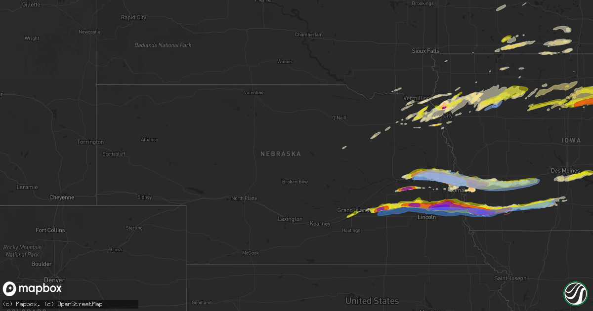
Hail Map in Nebraska on April 17, 2025
Get this storm
April 17 map
$229
one time, instant access
Download today. No call, no setup
Keep the $229
Bought the map and want the full workflow? Apply the entire $229 to a subscription within 7 days. None of it is wasted.
Every map, not just this one
This buys you this map. Subscription and you get every map we run, in the markets you choose from a few cities to whole states to nationwide. Plus real-time alerts the moment a storm fires.
Contact data
Name, contact info, occupancy, even credit band for addresses in the footprint. You go from where it hit to who to call.
Become the source they trust
Unlimited branding weather history reports on demand. You already have the documented answer ready for the property owner, and you are the one who showed up with it.
Property data and RoofTrace estimates
Pull up any address you have got, its value and the exact code rules for that jurisdiction, straight from One Click Code. Then RoofTrace estimates the squares, pitch, and roof value, priced the way you price.
Storm reports in Nebraska
Nebraska
| Date | Description |
|---|---|
| 04/17/20256:59 PM CDT | A local report indicates a tornado near 4 ENE Bennington |
| 04/17/20256:58 PM CDT | Report from mping: quarter |
| 04/17/20256:55 PM CDT | At approximately 6:55 pm cdt on thursday... April 17... A tornado developed near highway 133... And appeared to produce first damage by snapping limbs in an area of tre |
| 04/17/20256:55 PM CDT | A local report indicates 60 MPH wind near 4 E Kennard |
| 04/17/20256:53 PM CDT | Report from mping: quarter |
| 04/17/20256:52 PM CDT | Report from mping: golf ball |
| 04/17/20256:52 PM CDT | A local report indicates 2.75 inch wind near Bennington |
| 04/17/20256:50 PM CDT | A local report indicates 2.00 inch wind near 4 WSW Fort Calhoun |
| 04/17/20256:50 PM CDT | A local report indicates 1.00 inch wind near 1 SW Bennington |
| 04/17/20256:49 PM CDT | Report from mping: quarter |
| 04/17/20256:48 PM CDT | A local report indicates 1.00 inch wind near Davey |
| 04/17/20256:43 PM CDT | A local report indicates 1.00 inch wind near 2 S Nickerson |
| 04/17/20256:39 PM CDT | A local report indicates 1.75 inch wind near Kennard |
| 04/17/20256:38 PM CDT | A local report indicates 1.00 inch wind near Raymond |
| 04/17/20256:35 PM CDT | Corrects previous hail report from 5 sw valparaiso that originally said 1.75 inches. |
| 04/17/20256:35 PM CDT | A local report indicates 1.75 inch wind near 5 SW Valparaiso |
| 04/17/20256:34 PM CDT | A local report indicates 2.50 inch wind near 4 NW Arlington |
| 04/17/20256:34 PM CDT | A local report indicates 1.75 inch wind near Nickerson |
| 04/17/20256:30 PM CDT | A local report indicates 4.00 inch wind near Arlington |
| 04/17/20256:30 PM CDT | A local report indicates 2.00 inch wind near 6 NE Garland |
| 04/17/20256:28 PM CDT | Report from mping: baseball |
| 04/17/20256:27 PM CDT | A local report indicates 2.00 inch wind near 2 E Fremont |
| 04/17/20256:27 PM CDT | A local report indicates 2.00 inch wind near Bee |
| 04/17/20256:27 PM CDT | Report from mping: hen egg |
| 04/17/20256:26 PM CDT | A local report indicates 1.75 inch wind near 1 ENE Fremont |
| 04/17/20256:25 PM CDT | Windows broken by baseball-size hail 2 miles n of fremont. |
| 04/17/20256:25 PM CDT | A local report indicates 82 MPH wind near 1 WNW Fremont |
| 04/17/20256:24 PM CDT | Fremont airport. |
| 04/17/20256:21 PM CDT | Report from mping: baseball |
| 04/17/20256:21 PM CDT | Report from mping: hen egg |
| 04/17/20256:20 PM CDT | Mix of golfball and baseball-size hail. |
| 04/17/20256:08 PM CDT | A local report indicates 2.75 inch wind near 2 SW Kennard |
| 04/17/20255:59 PM CDT | Personal weather station. |
| 04/17/20255:58 PM CDT | A local report indicates 81 MPH wind near 1 E Rogers |
| 04/17/20255:56 PM CDT | Time estimated from radar. Actual measurement was 2.4. |
| 04/17/20255:53 PM CDT | Brief tornado may have occurred. Lots of dust with a weak circulation. |
| 04/17/20255:47 PM CDT | A local report indicates 1.00 inch wind near 5 NE Rogers |
| 04/17/20255:43 PM CDT | Estimated from outflow winds. Facebook message. |
| 04/17/20255:42 PM CDT | Time estimated from radar. |
| 04/17/20255:40 PM CDT | Delayed report. Hailed for about 10 minutes starting 540pm. Started small but ended up to golf ball size. |
| 04/17/20255:40 PM CDT | A local report indicates 1.50 inch wind near 5 NNE Bradshaw |
| 04/17/20255:25 PM CDT | Report from mping: half dollar time estimated from radar. |
| 04/17/20255:25 PM CDT | Report from mping: half dollar |
| 04/17/20255:23 PM CDT | A local report indicates 1.00 inch wind near 1 NE Hampton |
| 04/17/20255:11 PM CDT | Delayed report. |
| 04/17/20254:45 PM CDT | Delayed report from near intersection of shady bend road and highway 34. Hail dime to half dollar size. |
| 04/17/20254:40 PM CDT | Delayed report via social media photo. Location estimated from radar. |
| 04/17/20254:38 PM CDT | A few hail stones up to quarter size. Most smaller. |
| 04/17/20251:25 AM CDT | A local report indicates 1.25 inch wind near 2 WNW Ponca |
| 04/17/202512:34 AM CDT | Corrects time of previous hail report from 5 wsw martinsburg. |
| 04/17/202512:32 AM CDT | A local report indicates 1.00 inch wind near 5 WSW Martinsburg |
| 04/16/20258:08 PM CDT | A local report indicates 1.00 inch wind near 1 NE Homer |
| 04/16/20258:06 PM CDT | A local report indicates 1.50 inch wind near 1 N Homer |
| 04/16/20257:54 PM CDT | Report from mping: quarter |
| 04/16/20257:53 PM CDT | Tornado impacting residence. |
| 04/16/20257:50 PM CDT | A local report indicates 1.25 inch wind near Louisville |
| 04/16/20257:44 PM CDT | A local report indicates 1.00 inch wind near 2 NE Murray |
| 04/16/20257:41 PM CDT | Damage reported via omaha scanner on social media. |
| 04/16/20257:41 PM CDT | Report from mping: ping pong ball |
| 04/16/20257:41 PM CDT | A local report indicates a tornado near 1 WSW Manley |
| 04/16/20257:41 PM CDT | Report of damage via omaha scanner on social media. |
| 04/16/20257:40 PM CDT | Delayed report. |
| 04/16/20257:39 PM CDT | Report from mping: half dollar |
| 04/16/20257:36 PM CDT | A review of video evidence indicates that an intermittent tornado tracked off-and-on for approximately 5 minutes... Approaching but not reaching the town of manley. The |
| 04/16/20257:35 PM CDT | A local report indicates 1.25 inch wind near Weeping Water |
| 04/16/20257:28 PM CDT | A local report indicates 1.00 inch wind near South Bend |
| 04/16/20257:25 PM CDT | A local report indicates 1.00 inch wind near Louisville |
| 04/16/20257:24 PM CDT | Report relayed via social media. |
| 04/16/20257:22 PM CDT | A local report indicates a tornado near 3 SW Murdock |
| 04/16/20257:20 PM CDT | A review of video evidence confirms that an intermittent tornado tracked near this location for approximately 2 to 3 minutes... Passing through open fields. This tornad |
| 04/16/20257:15 PM CDT | Approximate location of tornado viewed on live feed. |
| 04/16/20257:14 PM CDT | Review of video evidence indicates that a tornado tracked for approximately 2 minutes with a maximum width of around 50 yards. It tracked through open fields and a few |
| 04/16/20257:13 PM CDT | A local report indicates 71 MPH wind near Alvo |
| 04/16/20257:13 PM CDT | Report from mping: hen egg |
| 04/16/20257:13 PM CDT | Report from mping: hen egg |
| 04/16/20257:07 PM CDT | A local report indicates 3.25 inch wind near 5 NNE Bennington |
| 04/16/20257:06 PM CDT | A local report indicates 2.75 inch wind near 2 NNW Greenwood |
| 04/16/20257:06 PM CDT | A local report indicates a tornado near 3 S Fort Calhoun |
| 04/16/20257:05 PM CDT | A local report indicates 2.00 inch wind near 1 N Blair |
| 04/16/20257:00 PM CDT | A local report indicates 1.75 inch wind near 2 NNW Greenwood |
All States Impacted by Hail Map on April 17, 2025
Cities Impacted by Hail Map on April 17, 2025
- Lewis, KS
- Belpre, KS
- Macksville, KS
- Junction City, KS
- Rich Hill, MO
- Butler, MO
- Central City, IA
- Alburnett, IA
- Center Point, IA
- Britt, IA
- Garner, IA
- Lake City, MN
- Zumbro Falls, MN
- Wabasha, MN
- Stillwater, MN
- Saint Paul, MN
- Willernie, MN
- Saint Croix Falls, WI
- Grantsburg, WI
- Menomonie, WI
- Elk Mound, WI
- Marine On Saint Croix, MN
- Hugo, MN
- Somerset, WI
- Eau Claire, WI
- Onamia, MN
- Osceola, WI
- New Richmond, WI
- Star Prairie, WI
- Dresser, WI
- Isle, MN
- Colfax, WI
- Siren, WI
- Amery, WI
- Chippewa Falls, WI
- Bloomer, WI
- Mcgregor, MN
- Balsam Lake, WI
- Cumberland, WI
- Sturgeon Lake, MN
- Webster, WI
- Aitkin, MN
- Kettle River, MN
- Tamarack, MN
- Comstock, WI
- Frederic, WI
- Barronett, WI
- Shell Lake, WI
- Spooner, WI
- Trego, WI
- Springbrook, WI
- Hillman, MN
- Hayward, WI
- Pequot Lakes, MN
- Nisswa, MN
- Saint Peter, MN
- Nicollet, MN
- Cokato, MN
- Winsted, MN
- Howard Lake, MN
- Gaylord, MN
- Le Sueur, MN
- Henderson, MN
- Arlington, MN
- Clearwater, MN
- Saint Cloud, MN
- South Haven, MN
- Sanborn, MN
- Clear Lake, MN
- Jackson, MN
- Springfield, MN
- New Ulm, MN
- Alpha, MN
- Trimont, MN
- Mountain Lake, MN
- Alda, NE
- Grand Island, NE
- Doniphan, NE
- Phillips, NE
- Zimmerman, MN
- Glenvil, NE
- Trumbull, NE
- Lawrence, NE
- Blue Hill, NE
- Guide Rock, NE
- Hastings, NE
- Aurora, NE
- Hampton, NE
- Bradshaw, NE
- York, NE
- Mapleton, MN
- Columbus, NE
- Schuyler, NE
- Minnesota Lake, MN
- Benedict, NE
- Waco, NE
- Stromsburg, NE
- Rogers, NE
- North Bend, NE
- Dodge, NE
- Howells, NE
- Scribner, NE
- Shelby, NE
- New Richland, MN
- Waldorf, MN
- Blue Earth, MN
- Rising City, NE
- David City, NE
- Bellwood, NE
- Gresham, NE
- Easton, MN
- Delavan, MN
- Linwood, NE
- Morse Bluff, NE
- Cedar Bluffs, NE
- Ames, NE
- Utica, NE
- Staplehurst, NE
- Ulysses, NE
- Henderson, NE
- Seward, NE
- Hooper, NE
- Fremont, NE
- Bricelyn, MN
- Wells, MN
- Nickerson, NE
- Bruno, NE
- Abie, NE
- Wood River, NE
- Raymond, NE
- Valparaiso, NE
- Garland, NE
- Bee, NE
- Elmore, MN
- Ledyard, IA
- Swea City, IA
- Buffalo Center, IA
- Alden, MN
- Winslow, NE
- Valley, NE
- Blair, NE
- Herman, NE
- Arlington, NE
- Missouri Valley, IA
- Bennington, NE
- Kennard, NE
- Dwight, NE
- Davey, NE
- Frost, MN
- Lincoln, NE
- Malmo, NE
- Prague, NE
- Ceresco, NE
- Malcolm, NE
- Waverly, NE
- Wahoo, NE
- Mead, NE
- Ithaca, NE
- Omaha, NE
- Fort Calhoun, NE
- Washington, NE
- Modale, IA
- Greenwood, NE
- Colon, NE
- Hayfield, MN
- Crescent, IA
- Honey Creek, IA
- Ashland, NE
- Alvo, NE
- Gretna, NE
- Murdock, NE
- Springfield, NE
- Byron, MN
- Kasson, MN
- Stewartville, MN
- Logan, IA
- Underwood, IA
- Neola, IA
- South Bend, NE
- Louisville, NE
- Weeping Water, NE
- Cedar Creek, NE
- Bellevue, NE
- Papillion, NE
- Plattsmouth, NE
- Murray, NE
- Nehawka, NE
- Waterloo, NE
- Lakefield, MN
- McClelland, IA
- Minden, IA
- Council Bluffs, IA
- Manley, NE
- Pleasant Dale, NE
- Eagle, NE
- Elmwood, NE
- Avoca, NE
- Union, NE
- Avoca, IA
- Sherburn, MN
- Alvord, IA
- Dunnell, MN
- Elkhorn, NE
- Hancock, IA
- Oakland, IA
- Treynor, IA
- Pacific Junction, IA
- Glenwood, IA
- Thurman, IA
- Tabor, IA
- Welcome, MN
- Rock Rapids, IA
- Boys Town, NE
- Malvern, IA
- Randolph, IA
- Hastings, IA
- Truman, MN
- Fairmont, MN
- Shelby, IA
- Walnut, IA
- Emerson, IA
- Griswold, IA
- Lewis, IA
- Atlantic, IA
- Sidney, IA
- Imogene, IA
- Salix, IA
- Bigelow, MN
- Granada, MN
- Marne, IA
- Hubbard, NE
- Homer, NE
- Sergeant Bluff, IA
- Bronson, IA
- Dakota City, NE
- Jackson, NE
- South Sioux City, NE
- Emerson, NE
- Essex, IA
- Red Oak, IA
- Wiota, IA
- Clarinda, IA
- Stanton, IA
- Farragut, IA
- Shenandoah, IA
- Villisca, IA
- Cumberland, IA
- Anita, IA
- Massena, IA
- Milford, IA
- Spencer, IA
- Dickens, IA
- Terril, IA
- Everly, IA
- Adair, IA
- Bridgewater, IA
- Casey, IA
- Fontanelle, IA
- Nodaway, IA
- Corning, IA
- Carson, IA
- Greenfield, IA
- Estherville, IA
- Menlo, IA
- Graettinger, IA
- Ringsted, IA
- Stuart, IA
- Forest City, IA
- Lenox, IA
- Prescott, IA
- Creston, IA
- Dexter, IA
- Afton, IA
- Emmons, MN
- Kiester, MN
- Norwalk, IA
- Cumming, IA
- Shannon City, IA
- Thayer, IA
- Lorimor, IA
- Pleasant Hill, IA
- Carlisle, IA
- Runnells, IA
- Albert Lea, MN
- Van Meter, IA
- Prairie City, IA
- Murray, IA
- Orient, IA
- Monroe, IA
- Twin Lakes, MN
- Prole, IA
- Hartford, IA
- Indianola, IA
- Swan, IA
- Des Moines, IA
- Reasnor, IA
- Osceola, IA
- Truro, IA
- New Virginia, IA
- Indian Springs, NV
- Woodburn, IA
- Lucas, IA
- Wynot, NE
- Pella, IA
- Lynnville, IA
- Sully, IA
- North Sioux City, SD
- Montezuma, IA
- Westfield, IA
- Sioux City, IA
- Hinton, IA
- Merrill, IA
- Elk Point, SD
- Burbank, SD
- Newcastle, NE
- New Sharon, IA
- Searsboro, IA
- Jefferson, SD
- Le Mars, IA
- Hartington, NE
- Laurel, NE
- Dixon, NE
- Concord, NE
- Akron, IA
- Allen, NE
- Waterbury, NE
- Lawton, IA
- Kingsley, IA
- Remsen, IA
- Ponca, NE
- Winnebago, NE
- Keota, IA
- Osmond, NE
- Plainview, NE
- Neligh, NE
- Tilden, NE
- Marcus, IA
- Mission Hill, SD
- Pierce, NE
- Quimby, IA
- Yankton, SD
- Harper, IA
- Sigourney, IA
- Holstein, IA
- Cherokee, IA
- Aurelia, IA
- Cleghorn, IA
- Randolph, NE
- Washta, IA
- Belden, NE
- Coleridge, NE
- Meriden, IA
- Larrabee, IA
- Wakefield, NE
- Alta, IA
- Storm Lake, IA
- Rembrandt, IA
- Truesdale, IA
- Newell, IA
- Albert City, IA
- Washington, IA
- Riverside, IA
- Moville, IA
- Peterson, IA
- Ainsworth, IA
- West Chester, IA
- Sioux Rapids, IA
- Marathon, IA
- Carroll, NE
- Fairhope, AL
- Summerdale, AL
- Columbus Junction, IA
- Linn Grove, IA
- Laurens, IA
- Havelock, IA
- Rolfe, IA
- Plover, IA
- Webb, IA
- Mallard, IA
- Curlew, IA
- West Bend, IA
- Pocahontas, IA
- Coden, AL
- Rutland, IA
- Gilmore City, IA
- Ottosen, IA
- Bradgate, IA
- Clare, IA
- Barnum, IA
- Bartlett, NE
- Manson, IA
- Palmer, IA
- Bode, IA
- Lu Verne, IA
- Livermore, IA
- Humboldt, IA
- Badger, IA
- Thor, IA
- Eagle Grove, IA
- Kanawha, IA
- Renwick, IA
- Hardy, IA
- Corwith, IA
- Goldfield, IA
- Clarion, IA
- Goodell, IA
- Thornton, IA
- Rowan, IA
- Belmond, IA
- Klemme, IA
- Vincent, IA
- Clear Lake, IA
- Meservey, IA
- Fort Dodge, IA
- Oyens, IA
- Galt, IA
- Dows, IA
- Alexander, IA
- Latimer, IA
- Sheffield, IA
- Ventura, IA
- Marble Rock, IA
- Dougherty, IA
- Rockwell, IA
- Woolstock, IA
- Greenville, IA
- Swaledale, IA
- Coulter, IA
- Hampton, IA
- Alden, IA
- Geneva, IA
- Ackley, IA
- Dumont, IA
- Aredale, IA
- Allison, IA
- Bristow, IA
- Greene, IA
- Charles City, IA
- Nashua, IA
- Emmetsburg, IA
- Clarksville, IA
- Shell Rock, IA
- Aplington, IA
- Waverly, IA
- Plainfield, IA
- Ionia, IA
- New Hampton, IA
- Fredericksburg, IA
- Janesville, IA
- Denver, IA
- Sumner, IA
- Tripoli, IA
- Readlyn, IA
- Lawler, IA
- Waucoma, IA
- Westgate, IA
- Fairbank, IA
- Oelwein, IA
- Maynard, IA
- Randalia, IA
- Hawkeye, IA
- Castalia, IA
- Fayette, IA
- Arlington, IA
- Wadena, IA
- Waukon, IA
- Monona, IA
- Luana, IA
- Postville, IA
- Volga, IA
- Elgin, IA
- Elkader, IA
- Steuben, WI
- Eastman, WI
- Gays Mills, WI
- Rockford, IA
- Harpers Ferry, IA
- Clermont, IA
- Waterville, IA
- Floyd, IA
- Rudd, IA
- Nora Springs, IA
- Boscobel, WI
- Mason City, IA
- Strawberry Point, IA
- Blue River, WI
- Soldiers Grove, WI
- Garnavillo, IA
- Garber, IA
- Muscoda, WI
- Richland Center, WI
- Aurora, IA
- Waterloo, IA
- Cedar Falls, IA
- Saint Olaf, IA
- Lamont, IA
- Wauzeka, WI
- Orchard, IA
- Farmersburg, IA
- Prairie Du Chien, WI
- Colwell, IA
- Chapin, IA
- Guttenberg, IA
- Elkport, IA
- Edgewood, IA
- Cassville, WI
- Glen Haven, WI
- Bagley, WI
- Bloomington, WI
- Lone Rock, WI
- Hillpoint, WI
- Plain, WI
- McGregor, IA
- Alta Vista, IA
- Spring Green, WI
- Gotham, WI
- Avoca, WI
- Mount Hope, WI
- Frederika, IA
- Colesburg, IA
- Potosi, WI
- Lancaster, WI
- Sauk City, WI
- Loganville, WI
- North Freedom, WI
- Prairie Du Sac, WI
- Holy Cross, IA
- New Vienna, IA
- Cazenovia, WI
- Baraboo, WI
- Platteville, WI
- Stitzer, WI
- Fennimore, WI
- Livingston, WI
- Lodi, WI
- Merrimac, WI
- West Union, IA
- Woodman, WI
- North Buena Vista, IA
- Sherrill, IA
- Montfort, WI
- Rewey, WI
- Belmont, WI
- Cobb, WI
- Mineral Point, WI
- Linden, WI
- Arlington, WI
- Poynette, WI
- Cuba City, WI
- Ormsby, MN
- Hartland, MN
- Rake, IA
- Highland, WI
- Lake Elmo, MN
- Dane, WI
- Dodgeville, WI
- Hazel Green, WI
- Darlington, WI
- Rio, WI
- Ridgeway, WI
- Arena, WI
- Blanchardville, WI
- Argyle, WI
- Blue Mounds, WI
- Mazomanie, WI
- Hollandale, WI
- Barneveld, WI
- Black Earth, WI
- Mount Horeb, WI
- Sutherland, IA
- Primghar, IA
- Correctionville, IA
- Pierson, IA
- Monticello, WI
- Belleville, WI
- Verona, WI
- New Glarus, WI
- Cross Plains, WI
- Oregon, WI
- Madison, WI
- Albany, WI
- Brooklyn, WI
- Middleton, WI
- Evansville, WI
- Stoughton, WI
- Cottage Grove, WI
- Deerfield, WI
- Mcfarland, WI
- Monroe, WI
- Sun Prairie, WI
- Cambridge, WI
- Otley, IA
- Galva, IA
- Alton, IA


