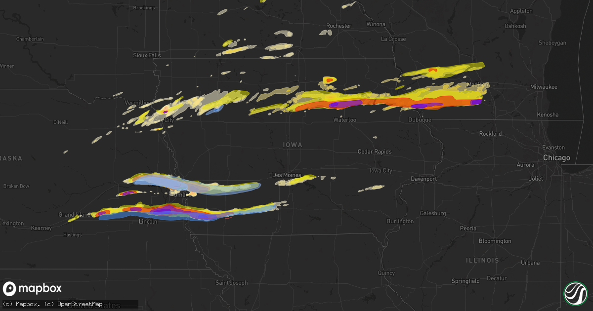
Hail Map in Iowa on April 17, 2025
Get this storm
April 17 map
$229
one time, instant access
Download today. No call, no setup
Keep the $229
Bought the map and want the full workflow? Apply the entire $229 to a subscription within 7 days. None of it is wasted.
Every map, not just this one
This buys you this map. Subscription and you get every map we run, in the markets you choose from a few cities to whole states to nationwide. Plus real-time alerts the moment a storm fires.
Contact data
Name, contact info, occupancy, even credit band for addresses in the footprint. You go from where it hit to who to call.
Become the source they trust
Unlimited branding weather history reports on demand. You already have the documented answer ready for the property owner, and you are the one who showed up with it.
Property data and RoofTrace estimates
Pull up any address you have got, its value and the exact code rules for that jurisdiction, straight from One Click Code. Then RoofTrace estimates the squares, pitch, and roof value, priced the way you price.
Storm reports in Iowa
Iowa
| Date | Description |
|---|---|
| 04/17/20256:20 AM CDT | Time estimated by radar. |
| 04/17/20256:11 AM CDT | Nickel to quarter sized hail. Time estimated by radar. |
| 04/17/20255:33 AM CDT | Siding damaged by wind driven hail. Via social media. |
| 04/17/20255:26 AM CDT | Report from mping: ping pong ball |
| 04/17/20255:13 AM CDT | Ground covered white in hail with largest hail at 1.5 inches in diameter. |
| 04/17/20255:10 AM CDT | A local report indicates 1.25 inch wind near 2 WSW Osterdock |
| 04/17/20255:07 AM CDT | Photos of tennis ball sized hail. |
| 04/17/20254:56 AM CDT | Report from mping: quarter |
| 04/17/20254:55 AM CDT | A local report indicates 2.00 inch wind near 1 NW Charles City |
| 04/17/20254:55 AM CDT | A local report indicates 1.50 inch wind near Charles City |
| 04/17/20254:54 AM CDT | A local report indicates 1.50 inch wind near 3 ENE Floyd |
| 04/17/20254:43 AM CDT | A local report indicates 1.00 inch wind near Sheffield |
| 04/17/20254:33 AM CDT | Iowa dot reports 3 semis blown over by strong winds on interstate 35 near milepost 174. |
| 04/17/20254:06 AM CDT | Numerous hailstones pictured with largest ping pong ball size. |
| 04/17/20254:00 AM CDT | A local report indicates 1.50 inch wind near 5 W Tripoli |
| 04/17/20253:52 AM CDT | Photo posted to social media. Time estimated from radar. |
| 04/17/20253:51 AM CDT | Photos of baseball sized hail north of waverly. Time is estimated from radar. |
| 04/17/20253:50 AM CDT | Report from mping: golf ball |
| 04/17/20253:18 AM CDT | Report from mping: quarter |
| 04/17/20253:17 AM CDT | Picture of numerous hailstones close to golf ball size. Occurred over several minutes. |
| 04/17/20253:12 AM CDT | Golf ball hail throughout hampton. |
| 04/17/20252:32 AM CDT | Report from mping: quarter |
| 04/17/20252:19 AM CDT | Delayed report: trained spotter/fire rescue reported quarter to half dollar sized hail. Time was estimated via radar. |
| 04/17/20252:19 AM CDT | Report from mping: quarter |
| 04/17/20251:57 AM CDT | A local report indicates 58 MPH wind near 1 W Sergeant Bluff |
| 04/17/20251:39 AM CDT | Picture via social media. |
| 04/17/20251:19 AM CDT | Via personal weather station. |
| 04/17/20251:10 AM CDT | Numerous photos of tree... Powerline... And roof damage across the city caused by straight-line winds estimated around 70 mph. |
| 04/17/20251:10 AM CDT | Received reports of powerlines down and trees down in storm lake... Iowa. Time estimated from radar. |
| 04/17/20251:08 AM CDT | Via personal weather station. |
| 04/17/20251:03 AM CDT | Report from social media. Time estimated from radar. |
| 04/17/20251:02 AM CDT | Report from mping: golf ball |
| 04/17/20251:00 AM CDT | Report from social media. Time estimated from radar. |
| 04/17/202512:23 AM CDT | Time estimated from radar. |
| 04/17/202512:23 AM CDT | Photos of estimated tennis ball size hail from social media. Time estimated from radar. |
| 04/16/202511:20 PM CDT | Report from mping: quarter |
| 04/16/202511:14 PM CDT | Social media report. |
| 04/16/202511:11 PM CDT | A local report indicates 1.25 inch wind near Murray |
| 04/16/202511:05 PM CDT | Social media report. |
| 04/16/202510:58 PM CDT | Quarter size hail at us 169 and us 34 intersection. |
| 04/16/202510:58 PM CDT | Quarter size hail at intersection of us 169 and us 34. |
| 04/16/202510:49 PM CDT | Dime to quarter size hail. |
| 04/16/202510:43 PM CDT | A local report indicates 1.00 inch wind near 1 SW Afton |
| 04/16/202510:24 PM CDT | 6 power poles broken between 2600 & 2700 block. Time estimated from radar. |
| 04/16/202510:22 PM CDT | Damage to farm building. Trees. And power lines. Time estimated from radar. |
| 04/16/202510:21 PM CDT | A lot of blowing dust occurring. |
| 04/16/202510:08 PM CDT | Measured on the north end of town. |
| 04/16/20259:53 PM CDT | A local report indicates 1.00 inch wind near Corning |
| 04/16/20259:49 PM CDT | Largest hail to 1 inch in diameter. |
| 04/16/20259:49 PM CDT | A local report indicates 1.50 inch wind near Corning |
| 04/16/20259:09 PM CDT | Measured with a personal weather station. |
| 04/16/20259:04 PM CDT | Personal weather station measured wind gust of 86 mph. Radar indicates the measurement was likely in the rfd. |
| 04/16/20259:00 PM CDT | Power poles snapped... Trees and shed material strewn over roadway. |
| 04/16/20258:58 PM CDT | Delayed report: a trained spotter reported nickel to ping-pong ball sized hail just south of archer. Timing was estimated via radar. |
| 04/16/20258:50 PM CDT | Tornado reported at pierce creek recreation area. |
| 04/16/20258:50 PM CDT | Golf ball to baseball size hail reported. |
| 04/16/20258:48 PM CDT | Corrects previous tornado report from 4 w essex. Power poles snapped... Trees and shed material strewn over roadway. Time estimated from radar. |
| 04/16/20258:46 PM CDT | Multiple trees down along 410th ave... Likely from a tornado track. |
| 04/16/20258:32 PM CDT | Possible report of a tornado between griswold and oakland... From trained spotter. |
| 04/16/20258:27 PM CDT | Live video feed and tds confirm tornado. |
| 04/16/20258:22 PM CDT | A local report indicates 1.00 inch wind near Lewis |
| 04/16/20258:21 PM CDT | A local report indicates a tornado near 3 S Tabor |
| 04/16/20258:16 PM CDT | A local report indicates 1.75 inch wind near 4 N Thurman |
| 04/16/20258:08 PM CDT | A local report indicates 1.75 inch wind near Hancock |
| 04/16/20257:51 PM CDT | Report from mping: quarter |
| 04/16/20257:44 PM CDT | A local report indicates 4.00 inch wind near 2 NW Mcclelland |
| 04/16/20257:39 PM CDT | A local report indicates 4.00 inch wind near 3 W Mcclelland |
| 04/16/20257:38 PM CDT | A local report indicates 1.25 inch wind near 2 SSE Minden |
| 04/16/20257:37 PM CDT | A local report indicates 2.75 inch wind near 2 N Mcclelland |
| 04/16/20257:31 PM CDT | A local report indicates 2.75 inch wind near 3 WNW Mcclelland |
| 04/16/20257:29 PM CDT | A local report indicates 2.75 inch wind near 4 SSW Underwood |
| 04/16/20257:28 PM CDT | A local report indicates 1.50 inch wind near 1 NE Underwood |
| 04/16/20257:24 PM CDT | A local report indicates 2.25 inch wind near 5 WSW Mcclelland |
All States Impacted by Hail Map on April 17, 2025
Cities Impacted by Hail Map on April 17, 2025
- Lewis, KS
- Belpre, KS
- Macksville, KS
- Junction City, KS
- Rich Hill, MO
- Butler, MO
- Central City, IA
- Alburnett, IA
- Center Point, IA
- Britt, IA
- Garner, IA
- Lake City, MN
- Zumbro Falls, MN
- Wabasha, MN
- Stillwater, MN
- Saint Paul, MN
- Willernie, MN
- Saint Croix Falls, WI
- Grantsburg, WI
- Menomonie, WI
- Elk Mound, WI
- Marine On Saint Croix, MN
- Hugo, MN
- Somerset, WI
- Eau Claire, WI
- Onamia, MN
- Osceola, WI
- New Richmond, WI
- Star Prairie, WI
- Dresser, WI
- Isle, MN
- Colfax, WI
- Siren, WI
- Amery, WI
- Chippewa Falls, WI
- Bloomer, WI
- Mcgregor, MN
- Balsam Lake, WI
- Cumberland, WI
- Sturgeon Lake, MN
- Webster, WI
- Aitkin, MN
- Kettle River, MN
- Tamarack, MN
- Comstock, WI
- Frederic, WI
- Barronett, WI
- Shell Lake, WI
- Spooner, WI
- Trego, WI
- Springbrook, WI
- Hillman, MN
- Hayward, WI
- Pequot Lakes, MN
- Nisswa, MN
- Saint Peter, MN
- Nicollet, MN
- Cokato, MN
- Winsted, MN
- Howard Lake, MN
- Gaylord, MN
- Le Sueur, MN
- Henderson, MN
- Arlington, MN
- Clearwater, MN
- Saint Cloud, MN
- South Haven, MN
- Sanborn, MN
- Clear Lake, MN
- Jackson, MN
- Springfield, MN
- New Ulm, MN
- Alpha, MN
- Trimont, MN
- Mountain Lake, MN
- Alda, NE
- Grand Island, NE
- Doniphan, NE
- Phillips, NE
- Zimmerman, MN
- Glenvil, NE
- Trumbull, NE
- Lawrence, NE
- Blue Hill, NE
- Guide Rock, NE
- Hastings, NE
- Aurora, NE
- Hampton, NE
- Bradshaw, NE
- York, NE
- Mapleton, MN
- Columbus, NE
- Schuyler, NE
- Minnesota Lake, MN
- Benedict, NE
- Waco, NE
- Stromsburg, NE
- Rogers, NE
- North Bend, NE
- Dodge, NE
- Howells, NE
- Scribner, NE
- Shelby, NE
- New Richland, MN
- Waldorf, MN
- Blue Earth, MN
- Rising City, NE
- David City, NE
- Bellwood, NE
- Gresham, NE
- Easton, MN
- Delavan, MN
- Linwood, NE
- Morse Bluff, NE
- Cedar Bluffs, NE
- Ames, NE
- Utica, NE
- Staplehurst, NE
- Ulysses, NE
- Henderson, NE
- Seward, NE
- Hooper, NE
- Fremont, NE
- Bricelyn, MN
- Wells, MN
- Nickerson, NE
- Bruno, NE
- Abie, NE
- Wood River, NE
- Raymond, NE
- Valparaiso, NE
- Garland, NE
- Bee, NE
- Elmore, MN
- Ledyard, IA
- Swea City, IA
- Buffalo Center, IA
- Alden, MN
- Winslow, NE
- Valley, NE
- Blair, NE
- Herman, NE
- Arlington, NE
- Missouri Valley, IA
- Bennington, NE
- Kennard, NE
- Dwight, NE
- Davey, NE
- Frost, MN
- Lincoln, NE
- Malmo, NE
- Prague, NE
- Ceresco, NE
- Malcolm, NE
- Waverly, NE
- Wahoo, NE
- Mead, NE
- Ithaca, NE
- Omaha, NE
- Fort Calhoun, NE
- Washington, NE
- Modale, IA
- Greenwood, NE
- Colon, NE
- Hayfield, MN
- Crescent, IA
- Honey Creek, IA
- Ashland, NE
- Alvo, NE
- Gretna, NE
- Murdock, NE
- Springfield, NE
- Byron, MN
- Kasson, MN
- Stewartville, MN
- Logan, IA
- Underwood, IA
- Neola, IA
- South Bend, NE
- Louisville, NE
- Weeping Water, NE
- Cedar Creek, NE
- Bellevue, NE
- Papillion, NE
- Plattsmouth, NE
- Murray, NE
- Nehawka, NE
- Waterloo, NE
- Lakefield, MN
- McClelland, IA
- Minden, IA
- Council Bluffs, IA
- Manley, NE
- Pleasant Dale, NE
- Eagle, NE
- Elmwood, NE
- Avoca, NE
- Union, NE
- Avoca, IA
- Sherburn, MN
- Alvord, IA
- Dunnell, MN
- Elkhorn, NE
- Hancock, IA
- Oakland, IA
- Treynor, IA
- Pacific Junction, IA
- Glenwood, IA
- Thurman, IA
- Tabor, IA
- Welcome, MN
- Rock Rapids, IA
- Boys Town, NE
- Malvern, IA
- Randolph, IA
- Hastings, IA
- Truman, MN
- Fairmont, MN
- Shelby, IA
- Walnut, IA
- Emerson, IA
- Griswold, IA
- Lewis, IA
- Atlantic, IA
- Sidney, IA
- Imogene, IA
- Salix, IA
- Bigelow, MN
- Granada, MN
- Marne, IA
- Hubbard, NE
- Homer, NE
- Sergeant Bluff, IA
- Bronson, IA
- Dakota City, NE
- Jackson, NE
- South Sioux City, NE
- Emerson, NE
- Essex, IA
- Red Oak, IA
- Wiota, IA
- Clarinda, IA
- Stanton, IA
- Farragut, IA
- Shenandoah, IA
- Villisca, IA
- Cumberland, IA
- Anita, IA
- Massena, IA
- Milford, IA
- Spencer, IA
- Dickens, IA
- Terril, IA
- Everly, IA
- Adair, IA
- Bridgewater, IA
- Casey, IA
- Fontanelle, IA
- Nodaway, IA
- Corning, IA
- Carson, IA
- Greenfield, IA
- Estherville, IA
- Menlo, IA
- Graettinger, IA
- Ringsted, IA
- Stuart, IA
- Forest City, IA
- Lenox, IA
- Prescott, IA
- Creston, IA
- Dexter, IA
- Afton, IA
- Emmons, MN
- Kiester, MN
- Norwalk, IA
- Cumming, IA
- Shannon City, IA
- Thayer, IA
- Lorimor, IA
- Pleasant Hill, IA
- Carlisle, IA
- Runnells, IA
- Albert Lea, MN
- Van Meter, IA
- Prairie City, IA
- Murray, IA
- Orient, IA
- Monroe, IA
- Twin Lakes, MN
- Prole, IA
- Hartford, IA
- Indianola, IA
- Swan, IA
- Des Moines, IA
- Reasnor, IA
- Osceola, IA
- Truro, IA
- New Virginia, IA
- Indian Springs, NV
- Woodburn, IA
- Lucas, IA
- Wynot, NE
- Pella, IA
- Lynnville, IA
- Sully, IA
- North Sioux City, SD
- Montezuma, IA
- Westfield, IA
- Sioux City, IA
- Hinton, IA
- Merrill, IA
- Elk Point, SD
- Burbank, SD
- Newcastle, NE
- New Sharon, IA
- Searsboro, IA
- Jefferson, SD
- Le Mars, IA
- Hartington, NE
- Laurel, NE
- Dixon, NE
- Concord, NE
- Akron, IA
- Allen, NE
- Waterbury, NE
- Lawton, IA
- Kingsley, IA
- Remsen, IA
- Ponca, NE
- Winnebago, NE
- Keota, IA
- Osmond, NE
- Plainview, NE
- Neligh, NE
- Tilden, NE
- Marcus, IA
- Mission Hill, SD
- Pierce, NE
- Quimby, IA
- Yankton, SD
- Harper, IA
- Sigourney, IA
- Holstein, IA
- Cherokee, IA
- Aurelia, IA
- Cleghorn, IA
- Randolph, NE
- Washta, IA
- Belden, NE
- Coleridge, NE
- Meriden, IA
- Larrabee, IA
- Wakefield, NE
- Alta, IA
- Storm Lake, IA
- Rembrandt, IA
- Truesdale, IA
- Newell, IA
- Albert City, IA
- Washington, IA
- Riverside, IA
- Moville, IA
- Peterson, IA
- Ainsworth, IA
- West Chester, IA
- Sioux Rapids, IA
- Marathon, IA
- Carroll, NE
- Fairhope, AL
- Summerdale, AL
- Columbus Junction, IA
- Linn Grove, IA
- Laurens, IA
- Havelock, IA
- Rolfe, IA
- Plover, IA
- Webb, IA
- Mallard, IA
- Curlew, IA
- West Bend, IA
- Pocahontas, IA
- Coden, AL
- Rutland, IA
- Gilmore City, IA
- Ottosen, IA
- Bradgate, IA
- Clare, IA
- Barnum, IA
- Bartlett, NE
- Manson, IA
- Palmer, IA
- Bode, IA
- Lu Verne, IA
- Livermore, IA
- Humboldt, IA
- Badger, IA
- Thor, IA
- Eagle Grove, IA
- Kanawha, IA
- Renwick, IA
- Hardy, IA
- Corwith, IA
- Goldfield, IA
- Clarion, IA
- Goodell, IA
- Thornton, IA
- Rowan, IA
- Belmond, IA
- Klemme, IA
- Vincent, IA
- Clear Lake, IA
- Meservey, IA
- Fort Dodge, IA
- Oyens, IA
- Galt, IA
- Dows, IA
- Alexander, IA
- Latimer, IA
- Sheffield, IA
- Ventura, IA
- Marble Rock, IA
- Dougherty, IA
- Rockwell, IA
- Woolstock, IA
- Greenville, IA
- Swaledale, IA
- Coulter, IA
- Hampton, IA
- Alden, IA
- Geneva, IA
- Ackley, IA
- Dumont, IA
- Aredale, IA
- Allison, IA
- Bristow, IA
- Greene, IA
- Charles City, IA
- Nashua, IA
- Emmetsburg, IA
- Clarksville, IA
- Shell Rock, IA
- Aplington, IA
- Waverly, IA
- Plainfield, IA
- Ionia, IA
- New Hampton, IA
- Fredericksburg, IA
- Janesville, IA
- Denver, IA
- Sumner, IA
- Tripoli, IA
- Readlyn, IA
- Lawler, IA
- Waucoma, IA
- Westgate, IA
- Fairbank, IA
- Oelwein, IA
- Maynard, IA
- Randalia, IA
- Hawkeye, IA
- Castalia, IA
- Fayette, IA
- Arlington, IA
- Wadena, IA
- Waukon, IA
- Monona, IA
- Luana, IA
- Postville, IA
- Volga, IA
- Elgin, IA
- Elkader, IA
- Steuben, WI
- Eastman, WI
- Gays Mills, WI
- Rockford, IA
- Harpers Ferry, IA
- Clermont, IA
- Waterville, IA
- Floyd, IA
- Rudd, IA
- Nora Springs, IA
- Boscobel, WI
- Mason City, IA
- Strawberry Point, IA
- Blue River, WI
- Soldiers Grove, WI
- Garnavillo, IA
- Garber, IA
- Muscoda, WI
- Richland Center, WI
- Aurora, IA
- Waterloo, IA
- Cedar Falls, IA
- Saint Olaf, IA
- Lamont, IA
- Wauzeka, WI
- Orchard, IA
- Farmersburg, IA
- Prairie Du Chien, WI
- Colwell, IA
- Chapin, IA
- Guttenberg, IA
- Elkport, IA
- Edgewood, IA
- Cassville, WI
- Glen Haven, WI
- Bagley, WI
- Bloomington, WI
- Lone Rock, WI
- Hillpoint, WI
- Plain, WI
- McGregor, IA
- Alta Vista, IA
- Spring Green, WI
- Gotham, WI
- Avoca, WI
- Mount Hope, WI
- Frederika, IA
- Colesburg, IA
- Potosi, WI
- Lancaster, WI
- Sauk City, WI
- Loganville, WI
- North Freedom, WI
- Prairie Du Sac, WI
- Holy Cross, IA
- New Vienna, IA
- Cazenovia, WI
- Baraboo, WI
- Platteville, WI
- Stitzer, WI
- Fennimore, WI
- Livingston, WI
- Lodi, WI
- Merrimac, WI
- West Union, IA
- Woodman, WI
- North Buena Vista, IA
- Sherrill, IA
- Montfort, WI
- Rewey, WI
- Belmont, WI
- Cobb, WI
- Mineral Point, WI
- Linden, WI
- Arlington, WI
- Poynette, WI
- Cuba City, WI
- Ormsby, MN
- Hartland, MN
- Rake, IA
- Highland, WI
- Lake Elmo, MN
- Dane, WI
- Dodgeville, WI
- Hazel Green, WI
- Darlington, WI
- Rio, WI
- Ridgeway, WI
- Arena, WI
- Blanchardville, WI
- Argyle, WI
- Blue Mounds, WI
- Mazomanie, WI
- Hollandale, WI
- Barneveld, WI
- Black Earth, WI
- Mount Horeb, WI
- Sutherland, IA
- Primghar, IA
- Correctionville, IA
- Pierson, IA
- Monticello, WI
- Belleville, WI
- Verona, WI
- New Glarus, WI
- Cross Plains, WI
- Oregon, WI
- Madison, WI
- Albany, WI
- Brooklyn, WI
- Middleton, WI
- Evansville, WI
- Stoughton, WI
- Cottage Grove, WI
- Deerfield, WI
- Mcfarland, WI
- Monroe, WI
- Sun Prairie, WI
- Cambridge, WI
- Otley, IA
- Galva, IA
- Alton, IA


