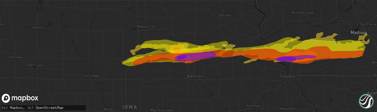
Hail Map in Waverly, IA on April 17, 2025
The weather event in Waverly, IA on April 17, 2025 includes Hail, Wind, and Tornado maps. 9 states and 594 cities were impacted and suffered possible damage. The total estimated number of properties impacted is 7,188.
Hail
Wind
Tornado
7,188
Estimated number of impacted properties by a 1.00" hail or larger6,036
Estimated number of impacted properties by a 1.75" hail or larger5,741
Estimated number of impacted properties by a 2.50" hail or largerStorm reports in Waverly, IA
Waverly, IA
| Date | Description |
|---|---|
| 04/17/20254:00 AM CDT | A local report indicates 1.50 inch wind near 5 W Tripoli |
| 04/17/20253:52 AM CDT | Photo posted to social media. Time estimated from radar. |
| 04/17/20253:51 AM CDT | Photos of baseball sized hail north of waverly. Time is estimated from radar. |
All States Impacted by Hail Map on April 17, 2025
All Cities Impacted by Hail Map on April 17, 2025
- Lewis, KS
- Belpre, KS
- Macksville, KS
- Junction City, KS
- Rich Hill, MO
- Butler, MO
- Central City, IA
- Alburnett, IA
- Center Point, IA
- Britt, IA
- Garner, IA
- Lake City, MN
- Zumbro Falls, MN
- Wabasha, MN
- Stillwater, MN
- Saint Paul, MN
- Willernie, MN
- Saint Croix Falls, WI
- Grantsburg, WI
- Menomonie, WI
- Elk Mound, WI
- Marine On Saint Croix, MN
- Hugo, MN
- Somerset, WI
- Eau Claire, WI
- Onamia, MN
- Osceola, WI
- New Richmond, WI
- Star Prairie, WI
- Dresser, WI
- Isle, MN
- Colfax, WI
- Siren, WI
- Amery, WI
- Chippewa Falls, WI
- Bloomer, WI
- Mcgregor, MN
- Balsam Lake, WI
- Cumberland, WI
- Sturgeon Lake, MN
- Webster, WI
- Aitkin, MN
- Kettle River, MN
- Tamarack, MN
- Comstock, WI
- Frederic, WI
- Barronett, WI
- Shell Lake, WI
- Spooner, WI
- Trego, WI
- Springbrook, WI
- Hillman, MN
- Hayward, WI
- Pequot Lakes, MN
- Nisswa, MN
- Saint Peter, MN
- Nicollet, MN
- Cokato, MN
- Winsted, MN
- Howard Lake, MN
- Gaylord, MN
- Le Sueur, MN
- Henderson, MN
- Arlington, MN
- Clearwater, MN
- Saint Cloud, MN
- South Haven, MN
- Sanborn, MN
- Clear Lake, MN
- Jackson, MN
- Springfield, MN
- New Ulm, MN
- Alpha, MN
- Trimont, MN
- Mountain Lake, MN
- Alda, NE
- Grand Island, NE
- Doniphan, NE
- Phillips, NE
- Zimmerman, MN
- Glenvil, NE
- Trumbull, NE
- Lawrence, NE
- Blue Hill, NE
- Guide Rock, NE
- Hastings, NE
- Aurora, NE
- Hampton, NE
- Bradshaw, NE
- York, NE
- Mapleton, MN
- Columbus, NE
- Schuyler, NE
- Minnesota Lake, MN
- Benedict, NE
- Waco, NE
- Stromsburg, NE
- Rogers, NE
- North Bend, NE
- Dodge, NE
- Howells, NE
- Scribner, NE
- Shelby, NE
- New Richland, MN
- Waldorf, MN
- Blue Earth, MN
- Rising City, NE
- David City, NE
- Bellwood, NE
- Gresham, NE
- Easton, MN
- Delavan, MN
- Linwood, NE
- Morse Bluff, NE
- Cedar Bluffs, NE
- Ames, NE
- Utica, NE
- Staplehurst, NE
- Ulysses, NE
- Henderson, NE
- Seward, NE
- Hooper, NE
- Fremont, NE
- Bricelyn, MN
- Wells, MN
- Nickerson, NE
- Bruno, NE
- Abie, NE
- Wood River, NE
- Raymond, NE
- Valparaiso, NE
- Garland, NE
- Bee, NE
- Elmore, MN
- Ledyard, IA
- Swea City, IA
- Buffalo Center, IA
- Alden, MN
- Winslow, NE
- Valley, NE
- Blair, NE
- Herman, NE
- Arlington, NE
- Missouri Valley, IA
- Bennington, NE
- Kennard, NE
- Dwight, NE
- Davey, NE
- Frost, MN
- Lincoln, NE
- Malmo, NE
- Prague, NE
- Ceresco, NE
- Malcolm, NE
- Waverly, NE
- Wahoo, NE
- Mead, NE
- Ithaca, NE
- Omaha, NE
- Fort Calhoun, NE
- Washington, NE
- Modale, IA
- Greenwood, NE
- Colon, NE
- Hayfield, MN
- Crescent, IA
- Honey Creek, IA
- Ashland, NE
- Alvo, NE
- Gretna, NE
- Murdock, NE
- Springfield, NE
- Byron, MN
- Kasson, MN
- Stewartville, MN
- Logan, IA
- Underwood, IA
- Neola, IA
- South Bend, NE
- Louisville, NE
- Weeping Water, NE
- Cedar Creek, NE
- Bellevue, NE
- Papillion, NE
- Plattsmouth, NE
- Murray, NE
- Nehawka, NE
- Waterloo, NE
- Lakefield, MN
- McClelland, IA
- Minden, IA
- Council Bluffs, IA
- Manley, NE
- Pleasant Dale, NE
- Eagle, NE
- Elmwood, NE
- Avoca, NE
- Union, NE
- Avoca, IA
- Sherburn, MN
- Alvord, IA
- Dunnell, MN
- Elkhorn, NE
- Hancock, IA
- Oakland, IA
- Treynor, IA
- Pacific Junction, IA
- Glenwood, IA
- Thurman, IA
- Tabor, IA
- Welcome, MN
- Rock Rapids, IA
- Boys Town, NE
- Malvern, IA
- Randolph, IA
- Hastings, IA
- Truman, MN
- Fairmont, MN
- Shelby, IA
- Walnut, IA
- Emerson, IA
- Griswold, IA
- Lewis, IA
- Atlantic, IA
- Sidney, IA
- Imogene, IA
- Salix, IA
- Bigelow, MN
- Granada, MN
- Marne, IA
- Hubbard, NE
- Homer, NE
- Sergeant Bluff, IA
- Bronson, IA
- Dakota City, NE
- Jackson, NE
- South Sioux City, NE
- Emerson, NE
- Essex, IA
- Red Oak, IA
- Wiota, IA
- Clarinda, IA
- Stanton, IA
- Farragut, IA
- Shenandoah, IA
- Villisca, IA
- Cumberland, IA
- Anita, IA
- Massena, IA
- Milford, IA
- Spencer, IA
- Dickens, IA
- Terril, IA
- Everly, IA
- Adair, IA
- Bridgewater, IA
- Casey, IA
- Fontanelle, IA
- Nodaway, IA
- Corning, IA
- Carson, IA
- Greenfield, IA
- Estherville, IA
- Menlo, IA
- Graettinger, IA
- Ringsted, IA
- Stuart, IA
- Forest City, IA
- Lenox, IA
- Prescott, IA
- Creston, IA
- Dexter, IA
- Afton, IA
- Emmons, MN
- Kiester, MN
- Norwalk, IA
- Cumming, IA
- Shannon City, IA
- Thayer, IA
- Lorimor, IA
- Pleasant Hill, IA
- Carlisle, IA
- Runnells, IA
- Albert Lea, MN
- Van Meter, IA
- Prairie City, IA
- Murray, IA
- Orient, IA
- Monroe, IA
- Twin Lakes, MN
- Prole, IA
- Hartford, IA
- Indianola, IA
- Swan, IA
- Des Moines, IA
- Reasnor, IA
- Osceola, IA
- Truro, IA
- New Virginia, IA
- Indian Springs, NV
- Woodburn, IA
- Lucas, IA
- Wynot, NE
- Pella, IA
- Lynnville, IA
- Sully, IA
- North Sioux City, SD
- Montezuma, IA
- Westfield, IA
- Sioux City, IA
- Hinton, IA
- Merrill, IA
- Elk Point, SD
- Burbank, SD
- Newcastle, NE
- New Sharon, IA
- Searsboro, IA
- Jefferson, SD
- Le Mars, IA
- Hartington, NE
- Laurel, NE
- Dixon, NE
- Concord, NE
- Akron, IA
- Allen, NE
- Waterbury, NE
- Lawton, IA
- Kingsley, IA
- Remsen, IA
- Ponca, NE
- Winnebago, NE
- Keota, IA
- Osmond, NE
- Plainview, NE
- Neligh, NE
- Tilden, NE
- Marcus, IA
- Mission Hill, SD
- Pierce, NE
- Quimby, IA
- Yankton, SD
- Harper, IA
- Sigourney, IA
- Holstein, IA
- Cherokee, IA
- Aurelia, IA
- Cleghorn, IA
- Randolph, NE
- Washta, IA
- Belden, NE
- Coleridge, NE
- Meriden, IA
- Larrabee, IA
- Wakefield, NE
- Alta, IA
- Storm Lake, IA
- Rembrandt, IA
- Truesdale, IA
- Newell, IA
- Albert City, IA
- Washington, IA
- Riverside, IA
- Moville, IA
- Peterson, IA
- Ainsworth, IA
- West Chester, IA
- Sioux Rapids, IA
- Marathon, IA
- Carroll, NE
- Fairhope, AL
- Summerdale, AL
- Columbus Junction, IA
- Linn Grove, IA
- Laurens, IA
- Havelock, IA
- Rolfe, IA
- Plover, IA
- Webb, IA
- Mallard, IA
- Curlew, IA
- West Bend, IA
- Pocahontas, IA
- Coden, AL
- Rutland, IA
- Gilmore City, IA
- Ottosen, IA
- Bradgate, IA
- Clare, IA
- Barnum, IA
- Bartlett, NE
- Manson, IA
- Palmer, IA
- Bode, IA
- Lu Verne, IA
- Livermore, IA
- Humboldt, IA
- Badger, IA
- Thor, IA
- Eagle Grove, IA
- Kanawha, IA
- Renwick, IA
- Hardy, IA
- Corwith, IA
- Goldfield, IA
- Clarion, IA
- Goodell, IA
- Thornton, IA
- Rowan, IA
- Belmond, IA
- Klemme, IA
- Vincent, IA
- Clear Lake, IA
- Meservey, IA
- Fort Dodge, IA
- Oyens, IA
- Galt, IA
- Dows, IA
- Alexander, IA
- Latimer, IA
- Sheffield, IA
- Ventura, IA
- Marble Rock, IA
- Dougherty, IA
- Rockwell, IA
- Woolstock, IA
- Greenville, IA
- Swaledale, IA
- Coulter, IA
- Hampton, IA
- Alden, IA
- Geneva, IA
- Ackley, IA
- Dumont, IA
- Aredale, IA
- Allison, IA
- Bristow, IA
- Greene, IA
- Charles City, IA
- Nashua, IA
- Emmetsburg, IA
- Clarksville, IA
- Shell Rock, IA
- Aplington, IA
- Waverly, IA
- Plainfield, IA
- Ionia, IA
- New Hampton, IA
- Fredericksburg, IA
- Janesville, IA
- Denver, IA
- Sumner, IA
- Tripoli, IA
- Readlyn, IA
- Lawler, IA
- Waucoma, IA
- Westgate, IA
- Fairbank, IA
- Oelwein, IA
- Maynard, IA
- Randalia, IA
- Hawkeye, IA
- Castalia, IA
- Fayette, IA
- Arlington, IA
- Wadena, IA
- Waukon, IA
- Monona, IA
- Luana, IA
- Postville, IA
- Volga, IA
- Elgin, IA
- Elkader, IA
- Steuben, WI
- Eastman, WI
- Gays Mills, WI
- Rockford, IA
- Harpers Ferry, IA
- Clermont, IA
- Waterville, IA
- Floyd, IA
- Rudd, IA
- Nora Springs, IA
- Boscobel, WI
- Mason City, IA
- Strawberry Point, IA
- Blue River, WI
- Soldiers Grove, WI
- Garnavillo, IA
- Garber, IA
- Muscoda, WI
- Richland Center, WI
- Aurora, IA
- Waterloo, IA
- Cedar Falls, IA
- Saint Olaf, IA
- Lamont, IA
- Wauzeka, WI
- Orchard, IA
- Farmersburg, IA
- Prairie Du Chien, WI
- Colwell, IA
- Chapin, IA
- Guttenberg, IA
- Elkport, IA
- Edgewood, IA
- Cassville, WI
- Glen Haven, WI
- Bagley, WI
- Bloomington, WI
- Lone Rock, WI
- Hillpoint, WI
- Plain, WI
- McGregor, IA
- Alta Vista, IA
- Spring Green, WI
- Gotham, WI
- Avoca, WI
- Mount Hope, WI
- Frederika, IA
- Colesburg, IA
- Potosi, WI
- Lancaster, WI
- Sauk City, WI
- Loganville, WI
- North Freedom, WI
- Prairie Du Sac, WI
- Holy Cross, IA
- New Vienna, IA
- Cazenovia, WI
- Baraboo, WI
- Platteville, WI
- Stitzer, WI
- Fennimore, WI
- Livingston, WI
- Lodi, WI
- Merrimac, WI
- West Union, IA
- Woodman, WI
- North Buena Vista, IA
- Sherrill, IA
- Montfort, WI
- Rewey, WI
- Belmont, WI
- Cobb, WI
- Mineral Point, WI
- Linden, WI
- Arlington, WI
- Poynette, WI
- Cuba City, WI
- Ormsby, MN
- Hartland, MN
- Rake, IA
- Highland, WI
- Lake Elmo, MN
- Dane, WI
- Dodgeville, WI
- Hazel Green, WI
- Darlington, WI
- Rio, WI
- Ridgeway, WI
- Arena, WI
- Blanchardville, WI
- Argyle, WI
- Blue Mounds, WI
- Mazomanie, WI
- Hollandale, WI
- Barneveld, WI
- Black Earth, WI
- Mount Horeb, WI
- Sutherland, IA
- Primghar, IA
- Correctionville, IA
- Pierson, IA
- Monticello, WI
- Belleville, WI
- Verona, WI
- New Glarus, WI
- Cross Plains, WI
- Oregon, WI
- Madison, WI
- Albany, WI
- Brooklyn, WI
- Middleton, WI
- Evansville, WI
- Stoughton, WI
- Cottage Grove, WI
- Deerfield, WI
- Mcfarland, WI
- Monroe, WI
- Sun Prairie, WI
- Cambridge, WI
- Otley, IA
- Galva, IA
- Alton, IA


