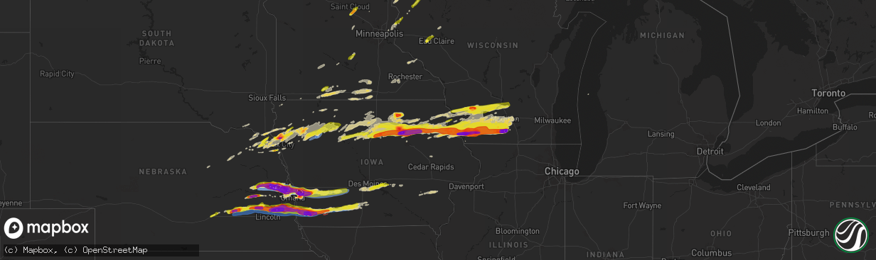
Hail Map on April 17, 2025
The weather event on April 17, 2025 includes Hail, Wind, and Tornado maps. 9 states and 594 cities were impacted and suffered possible damage. The total estimated number of properties impacted is 244,350.
Want more than just the map?
Turn this storm into a full workflow.
- Owner + property data so you know who to knock
- OnDemand branded weather history reports to win the "did we even have hail?" argument
- RoofTrace estimate so reps stop guessing numbers at the door
Bought this map? Upgrade within 7 days and we'll credit the $230. (10-15 min setup call)
Hail
Wind
Tornado
244,350
Estimated number of impacted properties by a 1.00" hail or larger100,692
Estimated number of impacted properties by a 1.75" hail or larger70,657
Estimated number of impacted properties by a 2.50" hail or largerStates Impacted by Hail Map on April 17, 2025
Storm reports
Nebraska
| Date | Description |
|---|---|
| 04/17/20256:59 PM CDT | A local report indicates a tornado near 4 ENE Bennington |
| 04/17/20256:58 PM CDT | Report from mping: quarter |
| 04/17/20256:55 PM CDT | At approximately 6:55 pm cdt on thursday... April 17... A tornado developed near highway 133... And appeared to produce first damage by snapping limbs in an area of tre |
| 04/17/20256:55 PM CDT | A local report indicates 60 MPH wind near 4 E Kennard |
| 04/17/20256:53 PM CDT | Report from mping: quarter |
| 04/17/20256:52 PM CDT | A local report indicates 2.75 inch wind near Bennington |
| 04/17/20256:52 PM CDT | Report from mping: golf ball |
| 04/17/20256:50 PM CDT | A local report indicates 1.00 inch wind near 1 SW Bennington |
| 04/17/20256:50 PM CDT | A local report indicates 2.00 inch wind near 4 WSW Fort Calhoun |
| 04/17/20256:49 PM CDT | Report from mping: quarter |
| 04/17/20256:48 PM CDT | A local report indicates 1.00 inch wind near Davey |
| 04/17/20256:43 PM CDT | A local report indicates 1.00 inch wind near 2 S Nickerson |
| 04/17/20256:39 PM CDT | A local report indicates 1.75 inch wind near Kennard |
| 04/17/20256:38 PM CDT | A local report indicates 1.00 inch wind near Raymond |
| 04/17/20256:35 PM CDT | A local report indicates 1.75 inch wind near 5 SW Valparaiso |
| 04/17/20256:35 PM CDT | Corrects previous hail report from 5 sw valparaiso that originally said 1.75 inches. |
| 04/17/20256:34 PM CDT | A local report indicates 2.50 inch wind near 4 NW Arlington |
| 04/17/20256:34 PM CDT | A local report indicates 1.75 inch wind near Nickerson |
| 04/17/20256:30 PM CDT | A local report indicates 2.00 inch wind near 6 NE Garland |
| 04/17/20256:30 PM CDT | A local report indicates 4.00 inch wind near Arlington |
| 04/17/20256:28 PM CDT | Report from mping: baseball |
| 04/17/20256:27 PM CDT | Report from mping: hen egg |
| 04/17/20256:27 PM CDT | A local report indicates 2.00 inch wind near Bee |
| 04/17/20256:27 PM CDT | A local report indicates 2.00 inch wind near 2 E Fremont |
| 04/17/20256:26 PM CDT | A local report indicates 1.75 inch wind near 1 ENE Fremont |
| 04/17/20256:25 PM CDT | A local report indicates 82 MPH wind near 1 WNW Fremont |
| 04/17/20256:25 PM CDT | Windows broken by baseball-size hail 2 miles n of fremont. |
| 04/17/20256:24 PM CDT | Fremont airport. |
| 04/17/20256:21 PM CDT | Report from mping: baseball |
| 04/17/20256:21 PM CDT | Report from mping: hen egg |
| 04/17/20256:20 PM CDT | Mix of golfball and baseball-size hail. |
| 04/17/20256:08 PM CDT | A local report indicates 2.75 inch wind near 2 SW Kennard |
| 04/17/20255:59 PM CDT | Personal weather station. |
| 04/17/20255:58 PM CDT | A local report indicates 81 MPH wind near 1 E Rogers |
| 04/17/20255:56 PM CDT | Time estimated from radar. Actual measurement was 2.4. |
| 04/17/20255:53 PM CDT | Brief tornado may have occurred. Lots of dust with a weak circulation. |
| 04/17/20255:47 PM CDT | A local report indicates 1.00 inch wind near 5 NE Rogers |
| 04/17/20255:43 PM CDT | Estimated from outflow winds. Facebook message. |
| 04/17/20255:42 PM CDT | Time estimated from radar. |
| 04/17/20255:40 PM CDT | Delayed report. Hailed for about 10 minutes starting 540pm. Started small but ended up to golf ball size. |
| 04/17/20255:40 PM CDT | A local report indicates 1.50 inch wind near 5 NNE Bradshaw |
| 04/17/20255:25 PM CDT | Report from mping: half dollar time estimated from radar. |
| 04/17/20255:25 PM CDT | Report from mping: half dollar |
| 04/17/20255:23 PM CDT | A local report indicates 1.00 inch wind near 1 NE Hampton |
| 04/17/20255:11 PM CDT | Delayed report. |
| 04/17/20254:45 PM CDT | Delayed report from near intersection of shady bend road and highway 34. Hail dime to half dollar size. |
| 04/17/20254:40 PM CDT | Delayed report via social media photo. Location estimated from radar. |
| 04/17/20254:38 PM CDT | A few hail stones up to quarter size. Most smaller. |
| 04/17/20251:25 AM CDT | A local report indicates 1.25 inch wind near 2 WNW Ponca |
| 04/17/202512:34 AM CDT | Corrects time of previous hail report from 5 wsw martinsburg. |
| 04/17/202512:32 AM CDT | A local report indicates 1.00 inch wind near 5 WSW Martinsburg |
| 04/16/20258:08 PM CDT | A local report indicates 1.00 inch wind near 1 NE Homer |
| 04/16/20258:06 PM CDT | A local report indicates 1.50 inch wind near 1 N Homer |
| 04/16/20257:54 PM CDT | Report from mping: quarter |
| 04/16/20257:53 PM CDT | Tornado impacting residence. |
| 04/16/20257:50 PM CDT | A local report indicates 1.25 inch wind near Louisville |
| 04/16/20257:44 PM CDT | A local report indicates 1.00 inch wind near 2 NE Murray |
| 04/16/20257:41 PM CDT | Report of damage via omaha scanner on social media. |
| 04/16/20257:41 PM CDT | A local report indicates a tornado near 1 WSW Manley |
| 04/16/20257:41 PM CDT | Report from mping: ping pong ball |
| 04/16/20257:41 PM CDT | Damage reported via omaha scanner on social media. |
| 04/16/20257:40 PM CDT | Delayed report. |
| 04/16/20257:39 PM CDT | Report from mping: half dollar |
| 04/16/20257:36 PM CDT | A review of video evidence indicates that an intermittent tornado tracked off-and-on for approximately 5 minutes... Approaching but not reaching the town of manley. The |
| 04/16/20257:35 PM CDT | A local report indicates 1.25 inch wind near Weeping Water |
| 04/16/20257:28 PM CDT | A local report indicates 1.00 inch wind near South Bend |
| 04/16/20257:25 PM CDT | A local report indicates 1.00 inch wind near Louisville |
| 04/16/20257:24 PM CDT | Report relayed via social media. |
| 04/16/20257:22 PM CDT | A local report indicates a tornado near 3 SW Murdock |
| 04/16/20257:20 PM CDT | A review of video evidence confirms that an intermittent tornado tracked near this location for approximately 2 to 3 minutes... Passing through open fields. This tornad |
| 04/16/20257:15 PM CDT | Approximate location of tornado viewed on live feed. |
| 04/16/20257:14 PM CDT | Review of video evidence indicates that a tornado tracked for approximately 2 minutes with a maximum width of around 50 yards. It tracked through open fields and a few |
| 04/16/20257:13 PM CDT | Report from mping: hen egg |
| 04/16/20257:13 PM CDT | Report from mping: hen egg |
| 04/16/20257:13 PM CDT | A local report indicates 71 MPH wind near Alvo |
| 04/16/20257:07 PM CDT | A local report indicates 3.25 inch wind near 5 NNE Bennington |
| 04/16/20257:06 PM CDT | A local report indicates a tornado near 3 S Fort Calhoun |
| 04/16/20257:06 PM CDT | A local report indicates 2.75 inch wind near 2 NNW Greenwood |
| 04/16/20257:05 PM CDT | A local report indicates 2.00 inch wind near 1 N Blair |
| 04/16/20257:00 PM CDT | A local report indicates 1.75 inch wind near 2 NNW Greenwood |
Minnesota
| Date | Description |
|---|---|
| 04/17/20255:48 PM CDT | Delayed report of a snapped 12 to 15 inch tree branch on the southern side of the faribault golf & country club. Time estimated from radar. |
| 04/17/20255:30 PM CDT | Power poles now have a lean and pull towards the ground. Part of the roof of a barn was damaged and blown into a grove of trees on the property. Time of damage estimate |
| 04/17/20253:15 PM CDT | Photo with ruler on x. Time estimated. |
| 04/17/20253:15 PM CDT | A local report indicates 1.25 inch wind near 3 SE Luxemburg |
| 04/17/20251:10 PM CDT | Corrects time of previous hail report from malmo. Time estimated from radar. |
| 04/17/202512:47 PM CDT | Report via social media with photo. |
| 04/17/202512:33 PM CDT | Report from mping: quarter |
| 04/17/202512:32 PM CDT | Social media photograph of a hailstone and quarter for comparison. Time estimated from radar. |
| 04/17/202512:26 PM CDT | A few quarter size hail stones. Mostly pea size. |
| 04/17/202512:20 PM CDT | Numerous hailstones between three quarters of an inch to 1.1 inches. Time from observer. |
| 04/17/202512:10 PM CDT | Time estimated from radar. |
South Dakota
| Date | Description |
|---|---|
| 04/17/202512:39 AM CDT | Via social media. |
| 04/17/202512:05 AM CDT | Report from mping: quarter |
Nevada
| Date | Description |
|---|---|
| 04/16/202511:00 PM CDT | A automated observing site in mercury nv recorded a wind gust of 63 mph at 2100. |
Arizona
| Date | Description |
|---|---|
| 04/16/20259:33 PM CDT | Tweeds point raws recorded a wind gust of 61 mph at 1933. |
Wisconsin
| Date | Description |
|---|---|
| 04/17/202512:49 PM CDT | Dime to quarter size hail. |
| 04/17/202512:45 PM CDT | Report via social media with photo. |
| 04/17/20256:59 AM CDT | A local report indicates 1.25 inch wind near Belmont |
| 04/17/20256:58 AM CDT | A local report indicates 2.00 inch wind near Evansville |
| 04/17/20256:58 AM CDT | Report from mping: quarter |
| 04/17/20256:58 AM CDT | A local report indicates 1.75 inch wind near Belmont |
| 04/17/20256:55 AM CDT | Hail likely larger as melting had occurred. |
| 04/17/20256:55 AM CDT | Relayed by wkow. Size estimated via picture. |
| 04/17/20256:53 AM CDT | Report from mping: half dollar |
| 04/17/20256:50 AM CDT | A local report indicates 1.00 inch wind near 1 SW Oregon |
| 04/17/20256:49 AM CDT | Report from mping: quarter |
| 04/17/20256:49 AM CDT | Report from mping: half dollar |
| 04/17/20256:49 AM CDT | A local report indicates 1.00 inch wind near Mcfarland |
| 04/17/20256:48 AM CDT | Report from mping: quarter |
| 04/17/20256:47 AM CDT | Report from mping: quarter |
| 04/17/20256:45 AM CDT | Measuring baseball sized hail as of 6:45 with very gusty winds as well. |
| 04/17/20256:45 AM CDT | Report from mping: quarter |
| 04/17/20256:45 AM CDT | A local report indicates 1.00 inch wind near 1 W Oregon |
| 04/17/20256:45 AM CDT | Report from mping: quarter |
| 04/17/20256:44 AM CDT | A local report indicates 2.00 inch wind near Monticello |
| 04/17/20256:41 AM CDT | A local report indicates 1.50 inch wind near New Glarus |
| 04/17/20256:41 AM CDT | A local report indicates 2.00 inch wind near 2 SSE New Glarus |
| 04/17/20256:40 AM CDT | A local report indicates 1.75 inch wind near Monticello |
| 04/17/20256:30 AM CDT | Picture with ruler on social media. |
| 04/17/20256:26 AM CDT | A local report indicates 2.50 inch wind near 1 W Platteville |
| 04/17/20256:20 AM CDT | A local report indicates 1.00 inch wind near 2 NE Monticello |
| 04/17/20256:15 AM CDT | A local report indicates 1.25 inch wind near 2 SE Hollandale |
| 04/17/20256:13 AM CDT | A local report indicates 2.00 inch wind near Darlington |
| 04/17/20256:10 AM CDT | A local report indicates 1.25 inch wind near 6 N Waldwick |
| 04/17/20256:05 AM CDT | Report from mping: half dollar |
| 04/17/20256:01 AM CDT | Measured tennis ball size hail as of 6:00am with wind gusts measured on home weather station of 68.2mph!. |
| 04/17/20255:59 AM CDT | A local report indicates 1.50 inch wind near 1 NW Platteville |
| 04/17/20255:58 AM CDT | A local report indicates 1.00 inch wind near 1 W Platteville |
| 04/17/20255:57 AM CDT | A local report indicates 2.75 inch wind near 3 W Platteville |
| 04/17/20255:55 AM CDT | A local report indicates 2.00 inch wind near 4 E Tennyson |
| 04/17/20255:55 AM CDT | Relayed via social media. |
| 04/17/20255:51 AM CDT | Size reference in picture on social media. |
| 04/17/20255:51 AM CDT | Report from mping: ping pong ball |
| 04/17/20255:36 AM CDT | Report from mping: half dollar |
| 04/17/20255:32 AM CDT | A local report indicates 1.75 inch wind near 3 W Platteville |
| 04/17/20255:29 AM CDT | A local report indicates 1.50 inch wind near 3 NNW Burton |
| 04/17/20255:12 AM CDT | A local report indicates 1.75 inch wind near 1 E Richland Center |
| 04/17/20255:11 AM CDT | A local report indicates 1.00 inch wind near Richland Center |
| 04/17/20255:10 AM CDT | From social media. Time estimated by radar. |
Iowa
| Date | Description |
|---|---|
| 04/17/20256:20 AM CDT | Time estimated by radar. |
| 04/17/20256:11 AM CDT | Nickel to quarter sized hail. Time estimated by radar. |
| 04/17/20255:33 AM CDT | Siding damaged by wind driven hail. Via social media. |
| 04/17/20255:26 AM CDT | Report from mping: ping pong ball |
| 04/17/20255:13 AM CDT | Ground covered white in hail with largest hail at 1.5 inches in diameter. |
| 04/17/20255:10 AM CDT | A local report indicates 1.25 inch wind near 2 WSW Osterdock |
| 04/17/20255:07 AM CDT | Photos of tennis ball sized hail. |
| 04/17/20254:56 AM CDT | Report from mping: quarter |
| 04/17/20254:55 AM CDT | A local report indicates 1.50 inch wind near Charles City |
| 04/17/20254:55 AM CDT | A local report indicates 2.00 inch wind near 1 NW Charles City |
| 04/17/20254:54 AM CDT | A local report indicates 1.50 inch wind near 3 ENE Floyd |
| 04/17/20254:43 AM CDT | A local report indicates 1.00 inch wind near Sheffield |
| 04/17/20254:33 AM CDT | Iowa dot reports 3 semis blown over by strong winds on interstate 35 near milepost 174. |
| 04/17/20254:06 AM CDT | Numerous hailstones pictured with largest ping pong ball size. |
| 04/17/20254:00 AM CDT | A local report indicates 1.50 inch wind near 5 W Tripoli |
| 04/17/20253:52 AM CDT | Photo posted to social media. Time estimated from radar. |
| 04/17/20253:51 AM CDT | Photos of baseball sized hail north of waverly. Time is estimated from radar. |
| 04/17/20253:50 AM CDT | Report from mping: golf ball |
| 04/17/20253:18 AM CDT | Report from mping: quarter |
| 04/17/20253:17 AM CDT | Picture of numerous hailstones close to golf ball size. Occurred over several minutes. |
| 04/17/20253:12 AM CDT | Golf ball hail throughout hampton. |
| 04/17/20252:32 AM CDT | Report from mping: quarter |
| 04/17/20252:19 AM CDT | Delayed report: trained spotter/fire rescue reported quarter to half dollar sized hail. Time was estimated via radar. |
| 04/17/20252:19 AM CDT | Report from mping: quarter |
| 04/17/20251:57 AM CDT | A local report indicates 58 MPH wind near 1 W Sergeant Bluff |
| 04/17/20251:39 AM CDT | Picture via social media. |
| 04/17/20251:19 AM CDT | Via personal weather station. |
| 04/17/20251:10 AM CDT | Received reports of powerlines down and trees down in storm lake... Iowa. Time estimated from radar. |
| 04/17/20251:10 AM CDT | Numerous photos of tree... Powerline... And roof damage across the city caused by straight-line winds estimated around 70 mph. |
| 04/17/20251:08 AM CDT | Via personal weather station. |
| 04/17/20251:03 AM CDT | Report from social media. Time estimated from radar. |
| 04/17/20251:02 AM CDT | Report from mping: golf ball |
| 04/17/20251:00 AM CDT | Report from social media. Time estimated from radar. |
| 04/17/202512:23 AM CDT | Time estimated from radar. |
| 04/17/202512:23 AM CDT | Photos of estimated tennis ball size hail from social media. Time estimated from radar. |
| 04/16/202511:20 PM CDT | Report from mping: quarter |
| 04/16/202511:14 PM CDT | Social media report. |
| 04/16/202511:11 PM CDT | A local report indicates 1.25 inch wind near Murray |
| 04/16/202511:05 PM CDT | Social media report. |
| 04/16/202510:58 PM CDT | Quarter size hail at us 169 and us 34 intersection. |
| 04/16/202510:58 PM CDT | Quarter size hail at intersection of us 169 and us 34. |
| 04/16/202510:49 PM CDT | Dime to quarter size hail. |
| 04/16/202510:43 PM CDT | A local report indicates 1.00 inch wind near 1 SW Afton |
| 04/16/202510:24 PM CDT | 6 power poles broken between 2600 & 2700 block. Time estimated from radar. |
| 04/16/202510:22 PM CDT | Damage to farm building. Trees. And power lines. Time estimated from radar. |
| 04/16/202510:21 PM CDT | A lot of blowing dust occurring. |
| 04/16/202510:08 PM CDT | Measured on the north end of town. |
| 04/16/20259:53 PM CDT | A local report indicates 1.00 inch wind near Corning |
| 04/16/20259:49 PM CDT | Largest hail to 1 inch in diameter. |
| 04/16/20259:49 PM CDT | A local report indicates 1.50 inch wind near Corning |
| 04/16/20259:09 PM CDT | Measured with a personal weather station. |
| 04/16/20259:04 PM CDT | Personal weather station measured wind gust of 86 mph. Radar indicates the measurement was likely in the rfd. |
| 04/16/20259:00 PM CDT | Power poles snapped... Trees and shed material strewn over roadway. |
| 04/16/20258:58 PM CDT | Delayed report: a trained spotter reported nickel to ping-pong ball sized hail just south of archer. Timing was estimated via radar. |
| 04/16/20258:50 PM CDT | Tornado reported at pierce creek recreation area. |
| 04/16/20258:50 PM CDT | Golf ball to baseball size hail reported. |
| 04/16/20258:48 PM CDT | Corrects previous tornado report from 4 w essex. Power poles snapped... Trees and shed material strewn over roadway. Time estimated from radar. |
| 04/16/20258:46 PM CDT | Multiple trees down along 410th ave... Likely from a tornado track. |
| 04/16/20258:32 PM CDT | Possible report of a tornado between griswold and oakland... From trained spotter. |
| 04/16/20258:27 PM CDT | Live video feed and tds confirm tornado. |
| 04/16/20258:22 PM CDT | A local report indicates 1.00 inch wind near Lewis |
| 04/16/20258:21 PM CDT | A local report indicates a tornado near 3 S Tabor |
| 04/16/20258:16 PM CDT | A local report indicates 1.75 inch wind near 4 N Thurman |
| 04/16/20258:08 PM CDT | A local report indicates 1.75 inch wind near Hancock |
| 04/16/20257:51 PM CDT | Report from mping: quarter |
| 04/16/20257:44 PM CDT | A local report indicates 4.00 inch wind near 2 NW Mcclelland |
| 04/16/20257:39 PM CDT | A local report indicates 4.00 inch wind near 3 W Mcclelland |
| 04/16/20257:38 PM CDT | A local report indicates 1.25 inch wind near 2 SSE Minden |
| 04/16/20257:37 PM CDT | A local report indicates 2.75 inch wind near 2 N Mcclelland |
| 04/16/20257:31 PM CDT | A local report indicates 2.75 inch wind near 3 WNW Mcclelland |
| 04/16/20257:29 PM CDT | A local report indicates 2.75 inch wind near 4 SSW Underwood |
| 04/16/20257:28 PM CDT | A local report indicates 1.50 inch wind near 1 NE Underwood |
| 04/16/20257:24 PM CDT | A local report indicates 2.25 inch wind near 5 WSW Mcclelland |
Cities Impacted by Hail Map on April 17, 2025
- Lewis, KS
- Belpre, KS
- Macksville, KS
- Junction City, KS
- Rich Hill, MO
- Butler, MO
- Central City, IA
- Alburnett, IA
- Center Point, IA
- Britt, IA
- Garner, IA
- Lake City, MN
- Zumbro Falls, MN
- Wabasha, MN
- Stillwater, MN
- Saint Paul, MN
- Willernie, MN
- Saint Croix Falls, WI
- Grantsburg, WI
- Menomonie, WI
- Elk Mound, WI
- Marine On Saint Croix, MN
- Hugo, MN
- Somerset, WI
- Eau Claire, WI
- Onamia, MN
- Osceola, WI
- New Richmond, WI
- Star Prairie, WI
- Dresser, WI
- Isle, MN
- Colfax, WI
- Siren, WI
- Amery, WI
- Chippewa Falls, WI
- Bloomer, WI
- Mcgregor, MN
- Balsam Lake, WI
- Cumberland, WI
- Sturgeon Lake, MN
- Webster, WI
- Aitkin, MN
- Kettle River, MN
- Tamarack, MN
- Comstock, WI
- Frederic, WI
- Barronett, WI
- Shell Lake, WI
- Spooner, WI
- Trego, WI
- Springbrook, WI
- Hillman, MN
- Hayward, WI
- Pequot Lakes, MN
- Nisswa, MN
- Saint Peter, MN
- Nicollet, MN
- Cokato, MN
- Winsted, MN
- Howard Lake, MN
- Gaylord, MN
- Le Sueur, MN
- Henderson, MN
- Arlington, MN
- Clearwater, MN
- Saint Cloud, MN
- South Haven, MN
- Sanborn, MN
- Clear Lake, MN
- Jackson, MN
- Springfield, MN
- New Ulm, MN
- Alpha, MN
- Trimont, MN
- Mountain Lake, MN
- Alda, NE
- Grand Island, NE
- Doniphan, NE
- Phillips, NE
- Zimmerman, MN
- Glenvil, NE
- Trumbull, NE
- Lawrence, NE
- Blue Hill, NE
- Guide Rock, NE
- Hastings, NE
- Aurora, NE
- Hampton, NE
- Bradshaw, NE
- York, NE
- Mapleton, MN
- Columbus, NE
- Schuyler, NE
- Minnesota Lake, MN
- Benedict, NE
- Waco, NE
- Stromsburg, NE
- Rogers, NE
- North Bend, NE
- Dodge, NE
- Howells, NE
- Scribner, NE
- Shelby, NE
- New Richland, MN
- Waldorf, MN
- Blue Earth, MN
- Rising City, NE
- David City, NE
- Bellwood, NE
- Gresham, NE
- Easton, MN
- Delavan, MN
- Linwood, NE
- Morse Bluff, NE
- Cedar Bluffs, NE
- Ames, NE
- Utica, NE
- Staplehurst, NE
- Ulysses, NE
- Henderson, NE
- Seward, NE
- Hooper, NE
- Fremont, NE
- Bricelyn, MN
- Wells, MN
- Nickerson, NE
- Bruno, NE
- Abie, NE
- Wood River, NE
- Raymond, NE
- Valparaiso, NE
- Garland, NE
- Bee, NE
- Elmore, MN
- Ledyard, IA
- Swea City, IA
- Buffalo Center, IA
- Alden, MN
- Winslow, NE
- Valley, NE
- Blair, NE
- Herman, NE
- Arlington, NE
- Missouri Valley, IA
- Bennington, NE
- Kennard, NE
- Dwight, NE
- Davey, NE
- Frost, MN
- Lincoln, NE
- Malmo, NE
- Prague, NE
- Ceresco, NE
- Malcolm, NE
- Waverly, NE
- Wahoo, NE
- Mead, NE
- Ithaca, NE
- Omaha, NE
- Fort Calhoun, NE
- Washington, NE
- Modale, IA
- Greenwood, NE
- Colon, NE
- Hayfield, MN
- Crescent, IA
- Honey Creek, IA
- Ashland, NE
- Alvo, NE
- Gretna, NE
- Murdock, NE
- Springfield, NE
- Byron, MN
- Kasson, MN
- Stewartville, MN
- Logan, IA
- Underwood, IA
- Neola, IA
- South Bend, NE
- Louisville, NE
- Weeping Water, NE
- Cedar Creek, NE
- Bellevue, NE
- Papillion, NE
- Plattsmouth, NE
- Murray, NE
- Nehawka, NE
- Waterloo, NE
- Lakefield, MN
- McClelland, IA
- Minden, IA
- Council Bluffs, IA
- Manley, NE
- Pleasant Dale, NE
- Eagle, NE
- Elmwood, NE
- Avoca, NE
- Union, NE
- Avoca, IA
- Sherburn, MN
- Alvord, IA
- Dunnell, MN
- Elkhorn, NE
- Hancock, IA
- Oakland, IA
- Treynor, IA
- Pacific Junction, IA
- Glenwood, IA
- Thurman, IA
- Tabor, IA
- Welcome, MN
- Rock Rapids, IA
- Boys Town, NE
- Malvern, IA
- Randolph, IA
- Hastings, IA
- Truman, MN
- Fairmont, MN
- Shelby, IA
- Walnut, IA
- Emerson, IA
- Griswold, IA
- Lewis, IA
- Atlantic, IA
- Sidney, IA
- Imogene, IA
- Salix, IA
- Bigelow, MN
- Granada, MN
- Marne, IA
- Hubbard, NE
- Homer, NE
- Sergeant Bluff, IA
- Bronson, IA
- Dakota City, NE
- Jackson, NE
- South Sioux City, NE
- Emerson, NE
- Essex, IA
- Red Oak, IA
- Wiota, IA
- Clarinda, IA
- Stanton, IA
- Farragut, IA
- Shenandoah, IA
- Villisca, IA
- Cumberland, IA
- Anita, IA
- Massena, IA
- Milford, IA
- Spencer, IA
- Dickens, IA
- Terril, IA
- Everly, IA
- Adair, IA
- Bridgewater, IA
- Casey, IA
- Fontanelle, IA
- Nodaway, IA
- Corning, IA
- Carson, IA
- Greenfield, IA
- Estherville, IA
- Menlo, IA
- Graettinger, IA
- Ringsted, IA
- Stuart, IA
- Forest City, IA
- Lenox, IA
- Prescott, IA
- Creston, IA
- Dexter, IA
- Afton, IA
- Emmons, MN
- Kiester, MN
- Norwalk, IA
- Cumming, IA
- Shannon City, IA
- Thayer, IA
- Lorimor, IA
- Pleasant Hill, IA
- Carlisle, IA
- Runnells, IA
- Albert Lea, MN
- Van Meter, IA
- Prairie City, IA
- Murray, IA
- Orient, IA
- Monroe, IA
- Twin Lakes, MN
- Prole, IA
- Hartford, IA
- Indianola, IA
- Swan, IA
- Des Moines, IA
- Reasnor, IA
- Osceola, IA
- Truro, IA
- New Virginia, IA
- Indian Springs, NV
- Woodburn, IA
- Lucas, IA
- Wynot, NE
- Pella, IA
- Lynnville, IA
- Sully, IA
- North Sioux City, SD
- Montezuma, IA
- Westfield, IA
- Sioux City, IA
- Hinton, IA
- Merrill, IA
- Elk Point, SD
- Burbank, SD
- Newcastle, NE
- New Sharon, IA
- Searsboro, IA
- Jefferson, SD
- Le Mars, IA
- Hartington, NE
- Laurel, NE
- Dixon, NE
- Concord, NE
- Akron, IA
- Allen, NE
- Waterbury, NE
- Lawton, IA
- Kingsley, IA
- Remsen, IA
- Ponca, NE
- Winnebago, NE
- Keota, IA
- Osmond, NE
- Plainview, NE
- Neligh, NE
- Tilden, NE
- Marcus, IA
- Mission Hill, SD
- Pierce, NE
- Quimby, IA
- Yankton, SD
- Harper, IA
- Sigourney, IA
- Holstein, IA
- Cherokee, IA
- Aurelia, IA
- Cleghorn, IA
- Randolph, NE
- Washta, IA
- Belden, NE
- Coleridge, NE
- Meriden, IA
- Larrabee, IA
- Wakefield, NE
- Alta, IA
- Storm Lake, IA
- Rembrandt, IA
- Truesdale, IA
- Newell, IA
- Albert City, IA
- Washington, IA
- Riverside, IA
- Moville, IA
- Peterson, IA
- Ainsworth, IA
- West Chester, IA
- Sioux Rapids, IA
- Marathon, IA
- Carroll, NE
- Fairhope, AL
- Summerdale, AL
- Columbus Junction, IA
- Linn Grove, IA
- Laurens, IA
- Havelock, IA
- Rolfe, IA
- Plover, IA
- Webb, IA
- Mallard, IA
- Curlew, IA
- West Bend, IA
- Pocahontas, IA
- Coden, AL
- Rutland, IA
- Gilmore City, IA
- Ottosen, IA
- Bradgate, IA
- Clare, IA
- Barnum, IA
- Bartlett, NE
- Manson, IA
- Palmer, IA
- Bode, IA
- Lu Verne, IA
- Livermore, IA
- Humboldt, IA
- Badger, IA
- Thor, IA
- Eagle Grove, IA
- Kanawha, IA
- Renwick, IA
- Hardy, IA
- Corwith, IA
- Goldfield, IA
- Clarion, IA
- Goodell, IA
- Thornton, IA
- Rowan, IA
- Belmond, IA
- Klemme, IA
- Vincent, IA
- Clear Lake, IA
- Meservey, IA
- Fort Dodge, IA
- Oyens, IA
- Galt, IA
- Dows, IA
- Alexander, IA
- Latimer, IA
- Sheffield, IA
- Ventura, IA
- Marble Rock, IA
- Dougherty, IA
- Rockwell, IA
- Woolstock, IA
- Greenville, IA
- Swaledale, IA
- Coulter, IA
- Hampton, IA
- Alden, IA
- Geneva, IA
- Ackley, IA
- Dumont, IA
- Aredale, IA
- Allison, IA
- Bristow, IA
- Greene, IA
- Charles City, IA
- Nashua, IA
- Emmetsburg, IA
- Clarksville, IA
- Shell Rock, IA
- Aplington, IA
- Waverly, IA
- Plainfield, IA
- Ionia, IA
- New Hampton, IA
- Fredericksburg, IA
- Janesville, IA
- Denver, IA
- Sumner, IA
- Tripoli, IA
- Readlyn, IA
- Lawler, IA
- Waucoma, IA
- Westgate, IA
- Fairbank, IA
- Oelwein, IA
- Maynard, IA
- Randalia, IA
- Hawkeye, IA
- Castalia, IA
- Fayette, IA
- Arlington, IA
- Wadena, IA
- Waukon, IA
- Monona, IA
- Luana, IA
- Postville, IA
- Volga, IA
- Elgin, IA
- Elkader, IA
- Steuben, WI
- Eastman, WI
- Gays Mills, WI
- Rockford, IA
- Harpers Ferry, IA
- Clermont, IA
- Waterville, IA
- Floyd, IA
- Rudd, IA
- Nora Springs, IA
- Boscobel, WI
- Mason City, IA
- Strawberry Point, IA
- Blue River, WI
- Soldiers Grove, WI
- Garnavillo, IA
- Garber, IA
- Muscoda, WI
- Richland Center, WI
- Aurora, IA
- Waterloo, IA
- Cedar Falls, IA
- Saint Olaf, IA
- Lamont, IA
- Wauzeka, WI
- Orchard, IA
- Farmersburg, IA
- Prairie Du Chien, WI
- Colwell, IA
- Chapin, IA
- Guttenberg, IA
- Elkport, IA
- Edgewood, IA
- Cassville, WI
- Glen Haven, WI
- Bagley, WI
- Bloomington, WI
- Lone Rock, WI
- Hillpoint, WI
- Plain, WI
- McGregor, IA
- Alta Vista, IA
- Spring Green, WI
- Gotham, WI
- Avoca, WI
- Mount Hope, WI
- Frederika, IA
- Colesburg, IA
- Potosi, WI
- Lancaster, WI
- Sauk City, WI
- Loganville, WI
- North Freedom, WI
- Prairie Du Sac, WI
- Holy Cross, IA
- New Vienna, IA
- Cazenovia, WI
- Baraboo, WI
- Platteville, WI
- Stitzer, WI
- Fennimore, WI
- Livingston, WI
- Lodi, WI
- Merrimac, WI
- West Union, IA
- Woodman, WI
- North Buena Vista, IA
- Sherrill, IA
- Montfort, WI
- Rewey, WI
- Belmont, WI
- Cobb, WI
- Mineral Point, WI
- Linden, WI
- Arlington, WI
- Poynette, WI
- Cuba City, WI
- Ormsby, MN
- Hartland, MN
- Rake, IA
- Highland, WI
- Lake Elmo, MN
- Dane, WI
- Dodgeville, WI
- Hazel Green, WI
- Darlington, WI
- Rio, WI
- Ridgeway, WI
- Arena, WI
- Blanchardville, WI
- Argyle, WI
- Blue Mounds, WI
- Mazomanie, WI
- Hollandale, WI
- Barneveld, WI
- Black Earth, WI
- Mount Horeb, WI
- Sutherland, IA
- Primghar, IA
- Correctionville, IA
- Pierson, IA
- Monticello, WI
- Belleville, WI
- Verona, WI
- New Glarus, WI
- Cross Plains, WI
- Oregon, WI
- Madison, WI
- Albany, WI
- Brooklyn, WI
- Middleton, WI
- Evansville, WI
- Stoughton, WI
- Cottage Grove, WI
- Deerfield, WI
- Mcfarland, WI
- Monroe, WI
- Sun Prairie, WI
- Cambridge, WI
- Otley, IA
- Galva, IA
- Alton, IA