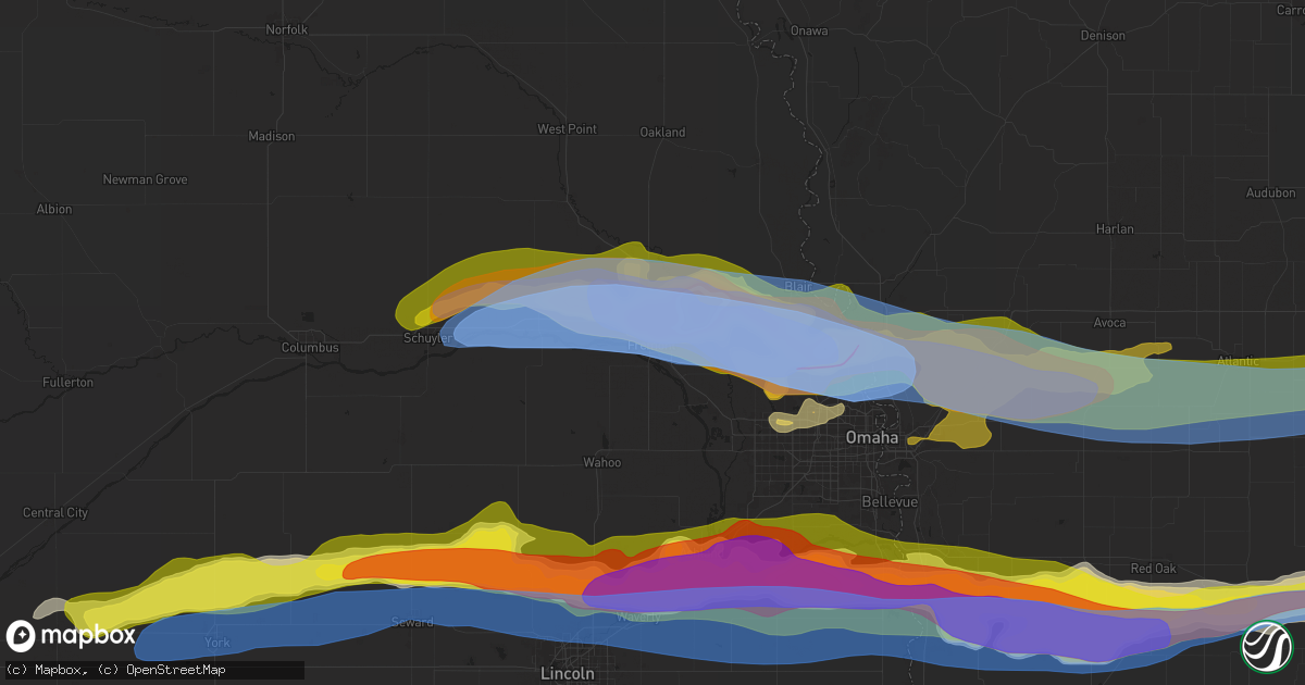
Hail Map in Fremont, NE on April 17, 2025
Get this storm
April 17 map
$229
one time, instant access
Download today. No call, no setup
Keep the $229
Bought the map and want the full workflow? Apply the entire $229 to a subscription within 7 days. None of it is wasted.
Every map, not just this one
This buys you this map. Subscription and you get every map we run, in the markets you choose from a few cities to whole states to nationwide. Plus real-time alerts the moment a storm fires.
Contact data
Name, contact info, occupancy, even credit band for addresses in the footprint. You go from where it hit to who to call.
Become the source they trust
Unlimited branding weather history reports on demand. You already have the documented answer ready for the property owner, and you are the one who showed up with it.
Property data and RoofTrace estimates
Pull up any address you have got, its value and the exact code rules for that jurisdiction, straight from One Click Code. Then RoofTrace estimates the squares, pitch, and roof value, priced the way you price.
Storm reports in Fremont, NE
Fremont, NE
| Date | Description |
|---|---|
| 04/17/20256:28 PM CDT | Report from mping: baseball |
| 04/17/20256:27 PM CDT | A local report indicates 2.00 inch wind near 2 E Fremont |
| 04/17/20256:27 PM CDT | Report from mping: hen egg |
| 04/17/20256:26 PM CDT | A local report indicates 1.75 inch wind near 1 ENE Fremont |
| 04/17/20256:25 PM CDT | Windows broken by baseball-size hail 2 miles n of fremont. |
| 04/17/20256:25 PM CDT | A local report indicates 82 MPH wind near 1 WNW Fremont |
| 04/17/20256:24 PM CDT | Fremont airport. |
| 04/17/20256:21 PM CDT | Report from mping: hen egg |
All States Impacted by Hail Map on April 17, 2025
All Cities Impacted by Hail Map on April 17, 2025
- Lewis, KS
- Belpre, KS
- Macksville, KS
- Junction City, KS
- Rich Hill, MO
- Butler, MO
- Central City, IA
- Alburnett, IA
- Center Point, IA
- Britt, IA
- Garner, IA
- Lake City, MN
- Zumbro Falls, MN
- Wabasha, MN
- Stillwater, MN
- Saint Paul, MN
- Willernie, MN
- Saint Croix Falls, WI
- Grantsburg, WI
- Menomonie, WI
- Elk Mound, WI
- Marine On Saint Croix, MN
- Hugo, MN
- Somerset, WI
- Eau Claire, WI
- Onamia, MN
- Osceola, WI
- New Richmond, WI
- Star Prairie, WI
- Dresser, WI
- Isle, MN
- Colfax, WI
- Siren, WI
- Amery, WI
- Chippewa Falls, WI
- Bloomer, WI
- Mcgregor, MN
- Balsam Lake, WI
- Cumberland, WI
- Sturgeon Lake, MN
- Webster, WI
- Aitkin, MN
- Kettle River, MN
- Tamarack, MN
- Comstock, WI
- Frederic, WI
- Barronett, WI
- Shell Lake, WI
- Spooner, WI
- Trego, WI
- Springbrook, WI
- Hillman, MN
- Hayward, WI
- Pequot Lakes, MN
- Nisswa, MN
- Saint Peter, MN
- Nicollet, MN
- Cokato, MN
- Winsted, MN
- Howard Lake, MN
- Gaylord, MN
- Le Sueur, MN
- Henderson, MN
- Arlington, MN
- Clearwater, MN
- Saint Cloud, MN
- South Haven, MN
- Sanborn, MN
- Clear Lake, MN
- Jackson, MN
- Springfield, MN
- New Ulm, MN
- Alpha, MN
- Trimont, MN
- Mountain Lake, MN
- Alda, NE
- Grand Island, NE
- Doniphan, NE
- Phillips, NE
- Zimmerman, MN
- Glenvil, NE
- Trumbull, NE
- Lawrence, NE
- Blue Hill, NE
- Guide Rock, NE
- Hastings, NE
- Aurora, NE
- Hampton, NE
- Bradshaw, NE
- York, NE
- Mapleton, MN
- Columbus, NE
- Schuyler, NE
- Minnesota Lake, MN
- Benedict, NE
- Waco, NE
- Stromsburg, NE
- Rogers, NE
- North Bend, NE
- Dodge, NE
- Howells, NE
- Scribner, NE
- Shelby, NE
- New Richland, MN
- Waldorf, MN
- Blue Earth, MN
- Rising City, NE
- David City, NE
- Bellwood, NE
- Gresham, NE
- Easton, MN
- Delavan, MN
- Linwood, NE
- Morse Bluff, NE
- Cedar Bluffs, NE
- Ames, NE
- Utica, NE
- Staplehurst, NE
- Ulysses, NE
- Henderson, NE
- Seward, NE
- Hooper, NE
- Fremont, NE
- Bricelyn, MN
- Wells, MN
- Nickerson, NE
- Bruno, NE
- Abie, NE
- Wood River, NE
- Raymond, NE
- Valparaiso, NE
- Garland, NE
- Bee, NE
- Elmore, MN
- Ledyard, IA
- Swea City, IA
- Buffalo Center, IA
- Alden, MN
- Winslow, NE
- Valley, NE
- Blair, NE
- Herman, NE
- Arlington, NE
- Missouri Valley, IA
- Bennington, NE
- Kennard, NE
- Dwight, NE
- Davey, NE
- Frost, MN
- Lincoln, NE
- Malmo, NE
- Prague, NE
- Ceresco, NE
- Malcolm, NE
- Waverly, NE
- Wahoo, NE
- Mead, NE
- Ithaca, NE
- Omaha, NE
- Fort Calhoun, NE
- Washington, NE
- Modale, IA
- Greenwood, NE
- Colon, NE
- Hayfield, MN
- Crescent, IA
- Honey Creek, IA
- Ashland, NE
- Alvo, NE
- Gretna, NE
- Murdock, NE
- Springfield, NE
- Byron, MN
- Kasson, MN
- Stewartville, MN
- Logan, IA
- Underwood, IA
- Neola, IA
- South Bend, NE
- Louisville, NE
- Weeping Water, NE
- Cedar Creek, NE
- Bellevue, NE
- Papillion, NE
- Plattsmouth, NE
- Murray, NE
- Nehawka, NE
- Waterloo, NE
- Lakefield, MN
- McClelland, IA
- Minden, IA
- Council Bluffs, IA
- Manley, NE
- Pleasant Dale, NE
- Eagle, NE
- Elmwood, NE
- Avoca, NE
- Union, NE
- Avoca, IA
- Sherburn, MN
- Alvord, IA
- Dunnell, MN
- Elkhorn, NE
- Hancock, IA
- Oakland, IA
- Treynor, IA
- Pacific Junction, IA
- Glenwood, IA
- Thurman, IA
- Tabor, IA
- Welcome, MN
- Rock Rapids, IA
- Boys Town, NE
- Malvern, IA
- Randolph, IA
- Hastings, IA
- Truman, MN
- Fairmont, MN
- Shelby, IA
- Walnut, IA
- Emerson, IA
- Griswold, IA
- Lewis, IA
- Atlantic, IA
- Sidney, IA
- Imogene, IA
- Salix, IA
- Bigelow, MN
- Granada, MN
- Marne, IA
- Hubbard, NE
- Homer, NE
- Sergeant Bluff, IA
- Bronson, IA
- Dakota City, NE
- Jackson, NE
- South Sioux City, NE
- Emerson, NE
- Essex, IA
- Red Oak, IA
- Wiota, IA
- Clarinda, IA
- Stanton, IA
- Farragut, IA
- Shenandoah, IA
- Villisca, IA
- Cumberland, IA
- Anita, IA
- Massena, IA
- Milford, IA
- Spencer, IA
- Dickens, IA
- Terril, IA
- Everly, IA
- Adair, IA
- Bridgewater, IA
- Casey, IA
- Fontanelle, IA
- Nodaway, IA
- Corning, IA
- Carson, IA
- Greenfield, IA
- Estherville, IA
- Menlo, IA
- Graettinger, IA
- Ringsted, IA
- Stuart, IA
- Forest City, IA
- Lenox, IA
- Prescott, IA
- Creston, IA
- Dexter, IA
- Afton, IA
- Emmons, MN
- Kiester, MN
- Norwalk, IA
- Cumming, IA
- Shannon City, IA
- Thayer, IA
- Lorimor, IA
- Pleasant Hill, IA
- Carlisle, IA
- Runnells, IA
- Albert Lea, MN
- Van Meter, IA
- Prairie City, IA
- Murray, IA
- Orient, IA
- Monroe, IA
- Twin Lakes, MN
- Prole, IA
- Hartford, IA
- Indianola, IA
- Swan, IA
- Des Moines, IA
- Reasnor, IA
- Osceola, IA
- Truro, IA
- New Virginia, IA
- Indian Springs, NV
- Woodburn, IA
- Lucas, IA
- Wynot, NE
- Pella, IA
- Lynnville, IA
- Sully, IA
- North Sioux City, SD
- Montezuma, IA
- Westfield, IA
- Sioux City, IA
- Hinton, IA
- Merrill, IA
- Elk Point, SD
- Burbank, SD
- Newcastle, NE
- New Sharon, IA
- Searsboro, IA
- Jefferson, SD
- Le Mars, IA
- Hartington, NE
- Laurel, NE
- Dixon, NE
- Concord, NE
- Akron, IA
- Allen, NE
- Waterbury, NE
- Lawton, IA
- Kingsley, IA
- Remsen, IA
- Ponca, NE
- Winnebago, NE
- Keota, IA
- Osmond, NE
- Plainview, NE
- Neligh, NE
- Tilden, NE
- Marcus, IA
- Mission Hill, SD
- Pierce, NE
- Quimby, IA
- Yankton, SD
- Harper, IA
- Sigourney, IA
- Holstein, IA
- Cherokee, IA
- Aurelia, IA
- Cleghorn, IA
- Randolph, NE
- Washta, IA
- Belden, NE
- Coleridge, NE
- Meriden, IA
- Larrabee, IA
- Wakefield, NE
- Alta, IA
- Storm Lake, IA
- Rembrandt, IA
- Truesdale, IA
- Newell, IA
- Albert City, IA
- Washington, IA
- Riverside, IA
- Moville, IA
- Peterson, IA
- Ainsworth, IA
- West Chester, IA
- Sioux Rapids, IA
- Marathon, IA
- Carroll, NE
- Fairhope, AL
- Summerdale, AL
- Columbus Junction, IA
- Linn Grove, IA
- Laurens, IA
- Havelock, IA
- Rolfe, IA
- Plover, IA
- Webb, IA
- Mallard, IA
- Curlew, IA
- West Bend, IA
- Pocahontas, IA
- Coden, AL
- Rutland, IA
- Gilmore City, IA
- Ottosen, IA
- Bradgate, IA
- Clare, IA
- Barnum, IA
- Bartlett, NE
- Manson, IA
- Palmer, IA
- Bode, IA
- Lu Verne, IA
- Livermore, IA
- Humboldt, IA
- Badger, IA
- Thor, IA
- Eagle Grove, IA
- Kanawha, IA
- Renwick, IA
- Hardy, IA
- Corwith, IA
- Goldfield, IA
- Clarion, IA
- Goodell, IA
- Thornton, IA
- Rowan, IA
- Belmond, IA
- Klemme, IA
- Vincent, IA
- Clear Lake, IA
- Meservey, IA
- Fort Dodge, IA
- Oyens, IA
- Galt, IA
- Dows, IA
- Alexander, IA
- Latimer, IA
- Sheffield, IA
- Ventura, IA
- Marble Rock, IA
- Dougherty, IA
- Rockwell, IA
- Woolstock, IA
- Greenville, IA
- Swaledale, IA
- Coulter, IA
- Hampton, IA
- Alden, IA
- Geneva, IA
- Ackley, IA
- Dumont, IA
- Aredale, IA
- Allison, IA
- Bristow, IA
- Greene, IA
- Charles City, IA
- Nashua, IA
- Emmetsburg, IA
- Clarksville, IA
- Shell Rock, IA
- Aplington, IA
- Waverly, IA
- Plainfield, IA
- Ionia, IA
- New Hampton, IA
- Fredericksburg, IA
- Janesville, IA
- Denver, IA
- Sumner, IA
- Tripoli, IA
- Readlyn, IA
- Lawler, IA
- Waucoma, IA
- Westgate, IA
- Fairbank, IA
- Oelwein, IA
- Maynard, IA
- Randalia, IA
- Hawkeye, IA
- Castalia, IA
- Fayette, IA
- Arlington, IA
- Wadena, IA
- Waukon, IA
- Monona, IA
- Luana, IA
- Postville, IA
- Volga, IA
- Elgin, IA
- Elkader, IA
- Steuben, WI
- Eastman, WI
- Gays Mills, WI
- Rockford, IA
- Harpers Ferry, IA
- Clermont, IA
- Waterville, IA
- Floyd, IA
- Rudd, IA
- Nora Springs, IA
- Boscobel, WI
- Mason City, IA
- Strawberry Point, IA
- Blue River, WI
- Soldiers Grove, WI
- Garnavillo, IA
- Garber, IA
- Muscoda, WI
- Richland Center, WI
- Aurora, IA
- Waterloo, IA
- Cedar Falls, IA
- Saint Olaf, IA
- Lamont, IA
- Wauzeka, WI
- Orchard, IA
- Farmersburg, IA
- Prairie Du Chien, WI
- Colwell, IA
- Chapin, IA
- Guttenberg, IA
- Elkport, IA
- Edgewood, IA
- Cassville, WI
- Glen Haven, WI
- Bagley, WI
- Bloomington, WI
- Lone Rock, WI
- Hillpoint, WI
- Plain, WI
- McGregor, IA
- Alta Vista, IA
- Spring Green, WI
- Gotham, WI
- Avoca, WI
- Mount Hope, WI
- Frederika, IA
- Colesburg, IA
- Potosi, WI
- Lancaster, WI
- Sauk City, WI
- Loganville, WI
- North Freedom, WI
- Prairie Du Sac, WI
- Holy Cross, IA
- New Vienna, IA
- Cazenovia, WI
- Baraboo, WI
- Platteville, WI
- Stitzer, WI
- Fennimore, WI
- Livingston, WI
- Lodi, WI
- Merrimac, WI
- West Union, IA
- Woodman, WI
- North Buena Vista, IA
- Sherrill, IA
- Montfort, WI
- Rewey, WI
- Belmont, WI
- Cobb, WI
- Mineral Point, WI
- Linden, WI
- Arlington, WI
- Poynette, WI
- Cuba City, WI
- Ormsby, MN
- Hartland, MN
- Rake, IA
- Highland, WI
- Lake Elmo, MN
- Dane, WI
- Dodgeville, WI
- Hazel Green, WI
- Darlington, WI
- Rio, WI
- Ridgeway, WI
- Arena, WI
- Blanchardville, WI
- Argyle, WI
- Blue Mounds, WI
- Mazomanie, WI
- Hollandale, WI
- Barneveld, WI
- Black Earth, WI
- Mount Horeb, WI
- Sutherland, IA
- Primghar, IA
- Correctionville, IA
- Pierson, IA
- Monticello, WI
- Belleville, WI
- Verona, WI
- New Glarus, WI
- Cross Plains, WI
- Oregon, WI
- Madison, WI
- Albany, WI
- Brooklyn, WI
- Middleton, WI
- Evansville, WI
- Stoughton, WI
- Cottage Grove, WI
- Deerfield, WI
- Mcfarland, WI
- Monroe, WI
- Sun Prairie, WI
- Cambridge, WI
- Otley, IA
- Galva, IA
- Alton, IA


