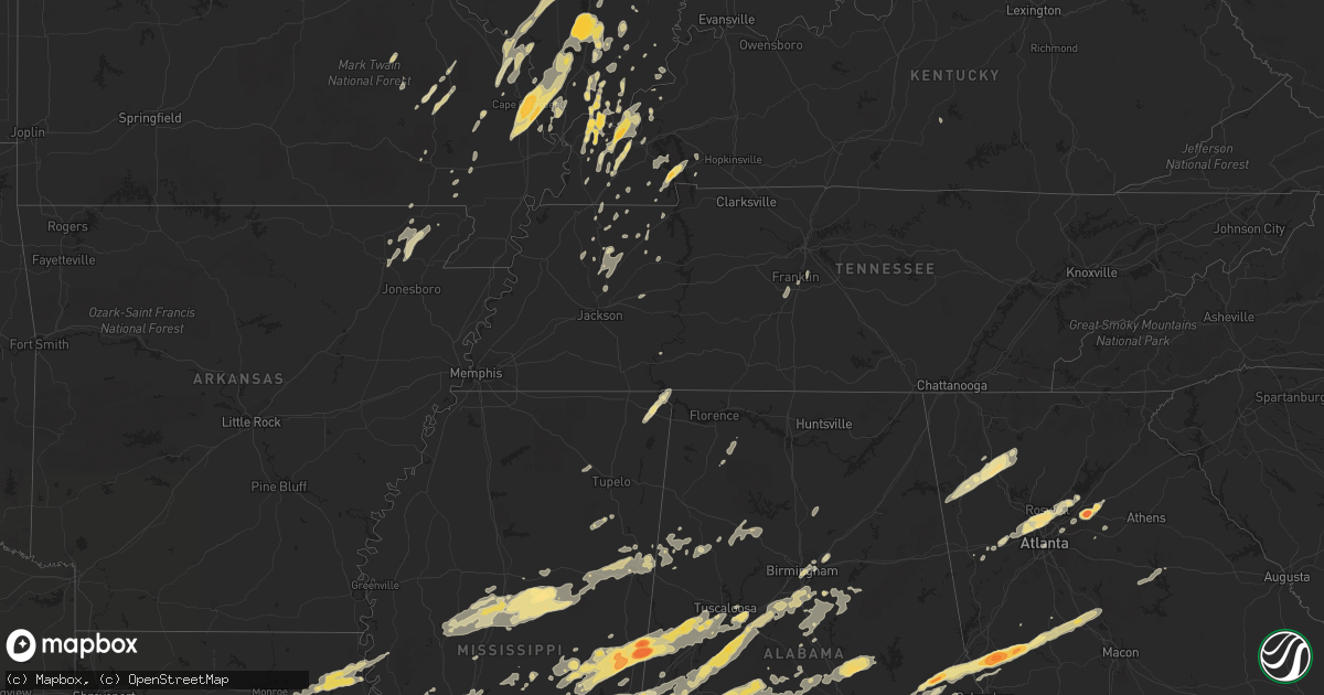
Hail Map in Tennessee on April 15, 2011
Get this storm
April 15 map
$229
one time, instant access
Download today. No call, no setup
Keep the $229
Bought the map and want the full workflow? Apply the entire $229 to a subscription within 7 days. None of it is wasted.
Every map, not just this one
This buys you this map. Subscription and you get every map we run, in the markets you choose from a few cities to whole states to nationwide. Plus real-time alerts the moment a storm fires.
Contact data
Name, contact info, occupancy, even credit band for addresses in the footprint. You go from where it hit to who to call.
Become the source they trust
Unlimited branding weather history reports on demand. You already have the documented answer ready for the property owner, and you are the one who showed up with it.
Property data and RoofTrace estimates
Pull up any address you have got, its value and the exact code rules for that jurisdiction, straight from One Click Code. Then RoofTrace estimates the squares, pitch, and roof value, priced the way you price.
Storm reports in Tennessee
Tennessee
| Date | Description |
|---|---|
| 04/15/20116:30 PM CDT | Dime to quarter size hail covering the ground. |
| 04/15/20116:28 PM CDT | Pea to quarter size hail reported near the intersection of mulberry road and old hwy 45. |
| 04/15/20114:36 PM CDT | Quarter size hail in dyer. |
| 04/15/20114:30 PM CDT | Quarter size hail reported by ham radio operator in union city. |
| 04/15/20113:45 PM CDT | Quarter size hail. |
| 04/15/20111:42 PM CDT | Tree blown down on a house at ewing blvd and a tree blown down on a car along north walnut st. |
| 04/15/201112:15 PM CDT | Trained spotter rpts trees uprooted and patio furniture blown across roads. |
| 04/15/20117:20 AM CDT | Trees down covering the roads in scotts hill. Also trees reported down in western henderson county. |
| 04/14/20118:40 PM CDT | Wilson county emergency management reported trees and power lines blown down on central pike near lebanon. |
| 04/14/20118:20 PM CDT | Spotter reported a tree blown down in la vergne. |
| 04/14/20118:15 PM CDT | Quarter size hail reported by spotter near brentwood. |
| 04/14/20118:15 PM CDT | Railroad signal gate blown down at stewarts ferry and mc campbell rd. |
| 04/14/20118:00 PM CDT | Pea to nickel size hail...with some pieces as large as quarter. |
| 04/14/20117:28 PM CDT | Quarter size hail in the town of paris. |
All States Impacted by Hail Map on April 15, 2011
Cities Impacted by Hail Map on April 15, 2011
- Ledbetter, KY
- Brookport, IL
- Jonesboro, IL
- McClure, IL
- Wolf Lake, IL
- Anna, IL
- Cape Girardeau, MO
- Scott City, MO
- Carbondale, IL
- Thebes, IL
- Makanda, IL
- Oran, MO
- Cobden, IL
- Chaffee, MO
- Tamms, IL
- Benton, MO
- Annapolis, MO
- Des Arc, MO
- Sawyerville, AL
- Cadiz, KY
- Murray, KY
- Mccomb, MS
- Tylertown, MS
- Jayess, MS
- Summit, MS
- Monroe, GA
- Jemison, AL
- Thorsby, AL
- Clanton, AL
- Vicksburg, MS
- Edwards, MS
- McIntosh, AL
- Tibbie, AL
- Deer Park, AL
- Grove Hill, AL
- Leroy, AL
- Gainestown, AL
- Wagarville, AL
- Sunflower, AL
- Jackson, AL
- Okolona, MS
- Perryville, MO
- West Paducah, KY
- Metropolis, IL
- Kevil, KY
- Porterville, MS
- Aliceville, AL
- Scooba, MS
- De Kalb, MS
- Emelle, AL
- Macon, MS
- Kilbourne, IL
- Bath, IL
- Sterrett, AL
- Columbiana, AL
- Wilsonville, AL
- Harpersville, AL
- Chelsea, AL
- Sullivan, MO
- Greensboro, GA
- Brookhaven, MS
- Trussville, AL
- Atlanta, GA
- Marietta, GA
- Greenville, AL
- Chandlerville, IL
- Petersburg, IL
- Ashland, IL
- Pleasant Plains, IL
- Tallula, IL
- Orrville, AL
- Marion Junction, AL
- Safford, AL
- Selma, AL
- Louisiana, MO
- Bowling Green, MO
- Tamaroa, IL
- Pinckneyville, IL
- Modesto, IL
- Waverly, IL
- Franklin, IL
- Hamilton, GA
- Pine Mountain Valley, GA
- Saint Louis, MO
- Starkville, MS
- West Point, MS
- Columbus, MS
- Mount Vernon, AL
- New London, MO
- Hannibal, MO
- Freeman Spur, IL
- Johnston City, IL
- Benton, IL
- Mulkeytown, IL
- Christopher, IL
- West Frankfort, IL
- Herrin, IL
- Zeigler, IL
- Buckner, IL
- Orient, IL
- Royalton, IL
- Peterman, AL
- Monroeville, AL
- Gloster, MS
- Pachuta, MS
- Stonewall, MS
- Quitman, MS
- Shubuta, MS
- Enterprise, MS
- Colchester, IL
- Tennessee, IL
- Calvert City, KY
- Virden, IL
- Morris Chapel, TN
- Villa Rica, GA
- Pinola, MS
- Mendenhall, MS
- Butler, AL
- Jachin, AL
- Alpharetta, GA
- Cumming, GA
- Austell, GA
- Roswell, GA
- Smyrna, GA
- Mableton, GA
- Suwanee, GA
- Duluth, GA
- Peachtree Corners, GA
- Waynesboro, MS
- McCool, MS
- French Camp, MS
- Ethel, MS
- Stewart, MS
- Kilmichael, MS
- Weir, MS
- Daleville, AL
- Ackerman, MS
- Vernon, AL
- Sulligent, AL
- Millport, AL
- Ava, IL
- Campbell Hill, IL
- Williamsville, MO
- Sweet Water, AL
- Pennington, AL
- Union, MS
- Angie, LA
- Lumberton, MS
- Franklinton, LA
- Purvis, MS
- Brooklyn, MS
- Hattiesburg, MS
- Poplarville, MS
- Forsyth, GA
- Barnesville, GA
- Carrier Mills, IL
- Harrisburg, IL
- Marquand, MO
- Greenville, MO
- Lodi, MO
- Fredericktown, MO
- Silva, MO
- Little Rock, MS
- Forest, MS
- Bruceton, TN
- Houston, MS
- Eolia, MO
- Baton Rouge, LA
- Sunshine, LA
- Saint Gabriel, LA
- Palmyra, IL
- Bunker Hill, IL
- Dorsey, IL
- Shipman, IL
- Greenfield, TN
- West, MS
- Durant, MS
- Lexington, MS
- Beaufort, MO
- Kinston, AL
- Samson, AL
- Wesson, MS
- Hazlehurst, MS
- Braxton, MS
- Magee, MS
- Salem, KY
- Burna, KY
- Coffeeville, AL
- State Line, MS
- Millry, AL
- Chatom, AL
- Richton, MS
- Frankville, AL
- Fruitdale, AL
- Neely, MS
- Fort Deposit, AL
- Beaumont, MS
- Vinegar Bend, AL
- Vredenburgh, AL
- Franklin, AL
- Beatrice, AL
- Frisco City, AL
- Kentwood, LA
- Mount Hermon, LA
- Pine Apple, AL
- McLain, MS
- Whatley, AL
- Leakesville, MS
- Greensburg, LA
- Forest Home, AL
- New Augusta, MS
- Tiline, KY
- Smithland, KY
- Dacula, GA
- Auburn, GA
- Lawrenceville, GA
- Hoschton, GA
- Buford, GA
- Raleigh, MS
- Louin, MS
- Thomasville, GA
- Tallahassee, FL
- Cairo, GA
- Havana, FL
- Marion, IL
- Creal Springs, IL
- Saint Francisville, LA
- Glenarm, IL
- Pawnee, IL
- Springfield, IL
- Birmingham, AL
- Smithdale, MS
- Seminary, MS
- Sumrall, MS
- Columbia, MS
- Moselle, MS
- Woodville, MS
- Monterey, LA
- Magnolia, MS
- Foxworth, MS
- Kokomo, MS
- Centreville, MS
- Ruth, MS
- Ellisville, MS
- Bassfield, MS
- Liberty, MS
- Ranger, GA
- Hermanville, MS
- Crystal Springs, MS
- Pattison, MS
- Silex, MO
- Frohna, MO
- Natchez, MS
- Fayette, MS
- Sardis, AL
- Fancy Farm, KY
- Cunningham, KY
- Melber, KY
- Monroe City, MO
- Palmyra, MO
- Saint Charles, MO
- Grafton, IL
- Brussels, IL
- Portage Des Sioux, MO
- Opp, AL
- Andalusia, AL
- Elba, AL
- Lindale, GA
- Rome, GA
- Silver Creek, GA
- Carthage, MS
- Wickliffe, KY
- Brewton, AL
- Cottondale, AL
- Meridian, MS
- Toomsuba, MS
- Chunky, MS
- Florence, MS
- Hickory, MS
- Marion, MS
- Decatur, MS
- Lake, MS
- Morton, MS
- Pulaski, MS
- Brandon, MS
- Newton, MS
- Lawrence, MS
- Auburn, AL
- Auburn University, AL
- Opelika, AL
- Thomaston, AL
- Faunsdale, AL
- Liverpool, IL
- Canton, IL
- Topeka, IL
- Lewistown, IL
- Hunnewell, MO
- Bogalusa, LA
- Monticello, FL
- Maryland Heights, MO
- Marthasville, MO
- Union, MO
- Washington, MO
- Augusta, MO
- Breaux Bridge, LA
- Saint Martinville, LA
- Chatham, IL
- Divernon, IL
- Plaucheville, LA
- Boligee, AL
- Bailey, MS
- Daleville, MS
- Philadelphia, MS
- Collinsville, MS
- Buckatunna, MS
- Pine Mountain, GA
- Warm Springs, GA
- Manchester, GA
- West Point, GA
- Shiloh, GA
- Sharon, TN
- Loganville, GA
- Rayville, LA
- Fosters, AL
- Ralph, AL
- Hartford, AL
- East Saint Louis, IL
- Madison, IL
- Granite City, IL
- Hayneville, AL
- Tyler, AL
- Blountsville, AL
- Hayden, AL
- Edinburg, IL
- Adairsville, GA
- Cartersville, GA
- Kingston, GA
- Fairmount, GA
- White, GA
- Calhoun, GA
- Cave Spring, GA
- Rydal, GA
- Middletown, MO
- Cedartown, GA
- Paulding, MS
- Plaquemine, LA
- Grosse Tete, LA
- Port Allen, LA
- Melvin, AL
- Gilbertown, AL
- Taylorsville, MS
- Bay Springs, MS
- Dongola, IL
- Villa Ridge, IL
- Ullin, IL
- Pulaski, IL
- Elmer, LA
- Karnak, IL
- Grand Chain, IL
- Toxey, AL
- Fayette, AL
- Lucedale, MS
- Citronelle, AL
- Jacob, IL
- Gorham, IL
- Saint Ann, MO
- Defiance, MO
- Foristell, MO
- Wentzville, MO
- Lake Saint Louis, MO
- Jackson, MS
- Madison, MS
- Ridgeland, MS
- Franklin, TN
- Valdosta, GA
- Quitman, GA
- Vaiden, MS
- Cantrall, IL
- Lorman, MS
- Union Church, MS
- Broughton, IL
- Hineston, LA
- Sieper, LA
- Alexander, IL
- Vossburg, MS
- Tuskegee, AL
- Mayfield, KY
- Paducah, KY
- Boaz, KY
- Symsonia, KY
- Hickory, KY
- Clinton, LA
- Wilson, LA
- Newhebron, MS
- Georgetown, MS
- Atmore, AL
- Vienna, IL
- Melville, LA
- Bunkie, LA
- Palmetto, LA
- Washington, LA
- Iuka, MS
- Laurel, MS
- Hartford, IL
- Wood River, IL
- East Alton, IL
- Roxana, IL
- Benton, KY
- Hardin, KY
- Equality, AL
- Rockford, AL
- Verbena, AL
- Marbury, AL
- Prattville, AL
- Deatsville, AL
- Titus, AL
- Eclectic, AL
- Wetumpka, AL
- Addis, LA
- Saint Clair, MO
- Golconda, IL
- Eddyville, IL
- Simpson, IL
- Bloomfield, MO
- Puxico, MO
- Dexter, MO
- Lovejoy, IL
- Venice, IL
- Villa Ridge, MO
- Gray Summit, MO
- Pacific, MO
- Caledonia, MS
- Coffee Springs, AL
- Labadie, MO
- Dresden, TN
- Palmersville, TN
- Duncanville, AL
- Knoxville, AL
- Moundville, AL
- Ethel, LA
- Jackson, LA
- Norwood, LA
- Riverton, IL
- Buffalo, IL
- Dawson, IL
- Williamsville, IL
- Ozark, IL
- Pineville, LA
- Center Point, LA
- Effie, LA
- Deville, LA
- Greenview, IL
- Athens, IL
- Camden, AL
- Columbia, IL
- Newellton, LA
- Silas, AL
- Morrisonville, IL
- Hollow Rock, TN
- McKenzie, TN
- Utica, MS
- Terry, MS
- Girard, IL
- Hazelwood, MO
- Bridgeton, MO
- Belknap, IL
- Grantsburg, IL
- Forkland, AL
- Thompsons Station, TN
- Steens, MS
- Goreville, IL
- Pine Hill, AL
- Thomasville, AL
- Kosciusko, MS
- Sallis, MS
- Tchula, MS
- Barlow, KY
- La Center, KY
- Trezevant, TN
- Atwood, TN
- Alto Pass, IL
- Pittsburg, IL
- Energy, IL
- Cambria, IL
- Thompsonville, IL
- Galatia, IL
- Logan, IL
- De Soto, IL
- Carterville, IL
- Pelham, AL
- Minter, AL
- Marion, KY
- Ewing, IL
- Belle Rive, IL
- Coila, MS
- Cruger, MS
- Eutaw, AL
- Batchelor, LA
- Center, MO
- Calera, AL
- Harrisville, MS
- Transylvania, LA
- Lake Providence, LA
- Epps, LA
- Delhi, LA
- Sondheimer, LA
- Pioneer, LA
- Walnut Grove, MS
- Phil Campbell, AL
- Lisman, AL
- Ward, AL
- York, AL
- Demopolis, AL
- Linden, AL
- Jerseyville, IL
- Fieldon, IL
- Kane, IL
- Florala, AL
- Enterprise, AL
- Tallulah, LA
- Earth City, MO
- Greensboro, AL
- Rockbridge, IL
- Rochester, IL
- Plymouth, IL
- Burnsville, MS
- Waterloo, AL
- Jasper, AL
- House Springs, MO
- High Ridge, MO
- Plantersville, AL
- Maplesville, AL
- Marble Hill, MO
- Alabaster, AL
- Helena, AL
- Billingsley, AL
- Salem, AL
- Woodland, GA
- The Rock, GA
- Notasulga, AL
- Meansville, GA
- Valley, AL
- Fortson, GA
- Thomaston, GA
- Molena, GA
- Cusseta, AL
- Cataula, GA
- Attapulgus, GA
- Whigham, GA
- Bellamy, AL
- Livingston, AL
- Carrollton, GA
- Raymond, MS
- Arlington, KY
- Hampton, KY
- Conehatta, MS
- Almo, KY
- Medina, TN
- Milan, TN
- Norcross, GA
- Stone Mountain, GA
- Tucker, GA
- Friedheim, MO
- Millersville, MO
- Daisy, MO
- Uniontown, MO
- Oak Ridge, MO
- Leslie, MO
- Cottage Hills, IL
- Alton, IL
- East Carondelet, IL
- Florissant, MO
- Bethalto, IL
- South Roxana, IL
- Zalma, MO
- Pelahatchie, MS
- Lauderdale, MS
- Cuba, AL
- Denham Springs, LA
- Prairieville, LA
- Gallion, AL
- Herod, IL
- Qulin, MO
- Wiggins, MS
- Hope Hull, AL
- Lowndesboro, AL
- Letohatchee, AL
- Evergreen, AL
- Saint Stephens, AL
- Georgetown, LA
- Winnfield, LA
- Caseyville, IL
- Collinsville, IL
- Akron, AL
- Jacksonville, IL
- Hazel, KY
- Shuqualak, MS
- Buhl, AL
- Tuscaloosa, AL
- Epes, AL
- Preston, MS
- Gainesville, AL
- Clinton, MS
- Bolton, MS
- Kinder, LA
- Welsh, LA
- Jennings, LA
- Woodbury, GA
- Greenville, GA
- Chancellor, AL
- Beech Grove, AR
- Delaplaine, AR
- Murrayville, IL
- Little River, AL
- Uriah, AL
- Sylacauga, AL
- Vincent, AL
- Childersburg, AL
- Eatonton, GA
- Booneville, MS
- Quincy, FL
- Chattahoochee, FL
- Belleview, MO
- Lettsworth, LA
- Simmesport, LA
- O'Fallon, MO
- Robertsville, MO
- Marion, AL
- Douglasville, GA
- Evangeline, LA
- Aberdeen, MS
- Bradford, TN
- Lena, MS
- Needham, AL
- Naylor, MO
- Rose Hill, MS
- McLeansboro, IL
- Belzoni, MS
- Goodman, MS
- Louisville, MS
- Yazoo City, MS
- Mississippi State, MS
- Sturgis, MS
- Dittmer, MO
- Eupora, MS
- Plainville, GA
- Bainbridge, GA
- Bessemer, AL
- West Blocton, AL
- Russellville, AL
- Rockwood, IL
- Altenburg, MO
- Jackson, MO
- Cutler, IL
- Crosby, MS
- Brent, AL
- Woodstock, AL
- Catherine, AL
- Heidelberg, MS
- McCalla, AL
- Vidalia, LA
- Newbern, AL
- Montevallo, AL
- Mize, MS
- Uniontown, AL
- Jones, AL
- Centreville, AL
- Vance, AL
- Ovett, MS
- Brierfield, AL
- Autaugaville, AL
- Corning, AR
- Marksville, LA
- Winston, GA
- Cairo, IL
- Miller City, IL
- Pocahontas, AR
- Grubville, MO
- Cedar Hill, MO
- Medora, IL
- Martin, TN
- Fulton, KY
- South Fulton, TN
- Nauvoo, AL
- Berry, AL
- Townley, AL
- Carbon Hill, AL
- Oakman, AL
- Vaughan, MS
- Slocomb, AL
- Newton, AL
- Geneva, AL
- New Brockton, AL
- Canton, MS
- Raleigh, IL
- Macedonia, IL
- Rector, AR
- Wright City, MO
- Maryville, IL
- Carrollton, IL
- Castleberry, AL
- Repton, AL
- Clinton, KY
- Slaughter, LA
- Iota, LA
- Egan, LA
- Crowley, LA
- Ballwin, MO
- Oakford, IL
- Buncombe, IL
- Mount Hope, AL
- Town Creek, AL
- Peach Orchard, AR
- Fenton, MO
- Leesville, LA
- Otis, LA
- New Berlin, IL
- Stockton, AL
- Eureka, MO
- New Burnside, IL
- Stonefort, IL
- Gleason, TN
- Henry, TN
- Paris, TN
- Alpine, AL
- Flovilla, GA
- Pearl, MS
- Flomaton, AL
- Hamilton, MS
- Waverly Hall, GA
- White Hall, IL
- Roodhouse, IL
- Fisk, MO
- Broseley, MO
- Knobel, AR
- Paragould, AR
- Bono, AR
- Dyer, TN
- Rutherford, TN
- Hettick, IL
- Greenfield, IL
- Fort Rucker, AL
- De Soto, MO
- Festus, MO
- Farmersville, IL
- Sedalia, KY
- Harvel, IL
- Elsah, IL
- Dow, IL
- Junction, IL
- Ridgway, IL
- Luebbering, MO
- Richwoods, MO
- Beaverton, AL
- Farrar, MO
- Ecru, MS
- Pontotoc, MS
- Blue Springs, MS
- Trenton, TN
- Cave In Rock, IL
- Elizabethtown, IL
- Hardin, IL
- Batchtown, IL
- Mansfield, TN
- Carlinville, IL
- Bankston, AL
- Poplar Bluff, MO
- Table Grove, IL
- Golden Eagle, IL
- Hamburg, IL
- Zebulon, GA
- Alexandria, LA
- Shelby, AL
- Kennedy, AL
- Greensburg, KY
- Fort Polk, LA
- Pitkin, LA
- Dry Prong, LA
- Atlanta, LA
- Olla, LA
- Tullos, LA
- Loami, IL
- Powder Springs, GA
- Oberlin, LA
- Madison, GA
- Buckhead, GA
- Warrenton, MO
- Spring Hill, TN
- Wingo, KY
- Buchanan, TN
- Walnut Ridge, AR
- Lexington, TN
- Wildersville, TN
- Clarkdale, GA
- Lithia Springs, GA
- Havana, IL
- Easton, IL
- Hull, IL
- Equality, IL
- Dothan, AL
- Rolling Fork, MS
- Oak Ridge, LA
- Mayersville, MS
- Bardwell, KY
- Edwardsville, IL
- Moro, IL
- Burfordville, MO
- Biggers, AR
- Dudley, MO
- Cottage Grove, TN
- Ironton, MO
- Lilburn, GA
- Gilbert, LA
- Brentwood, TN
- Farmington, KY
- Patterson, MO
- Troy, MO
- Lesterville, MO


