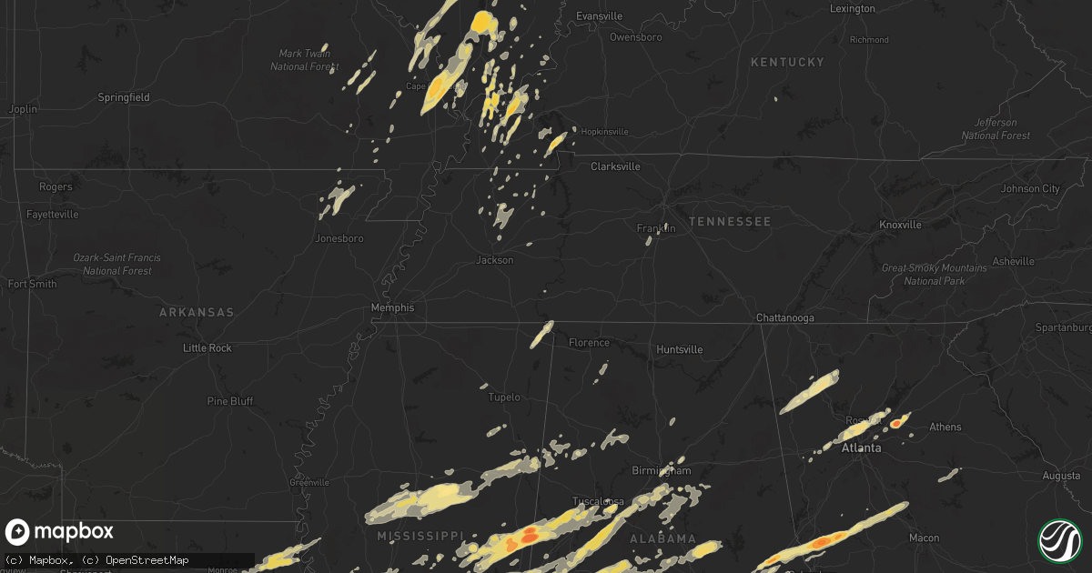
Hail Map in Illinois on April 15, 2011
Get this storm
April 15 map
$229
one time, instant access
Download today. No call, no setup
Keep the $229
Bought the map and want the full workflow? Apply the entire $229 to a subscription within 7 days. None of it is wasted.
Every map, not just this one
This buys you this map. Subscription and you get every map we run, in the markets you choose from a few cities to whole states to nationwide. Plus real-time alerts the moment a storm fires.
Contact data
Name, contact info, occupancy, even credit band for addresses in the footprint. You go from where it hit to who to call.
Become the source they trust
Unlimited branding weather history reports on demand. You already have the documented answer ready for the property owner, and you are the one who showed up with it.
Property data and RoofTrace estimates
Pull up any address you have got, its value and the exact code rules for that jurisdiction, straight from One Click Code. Then RoofTrace estimates the squares, pitch, and roof value, priced the way you price.
Storm reports in Illinois
Illinois
| Date | Description |
|---|---|
| 04/15/20116:50 PM CDT | Tree down on house |
| 04/15/20116:49 PM CDT | A local report indicates 1.00 inch wind near METROPOLIS |
| 04/15/20116:40 PM CDT | Quarter size hail reported. |
| 04/15/20116:30 PM CDT | A local report indicates 1.00 inch wind near WEST FRANKFORT |
| 04/15/20116:30 PM CDT | A local report indicates 1.00 inch wind near 8 W PETERSBURG |
| 04/15/20116:26 PM CDT | 3-4 inch tree limbs down...many yard items blown 1-2 blocks down street. |
| 04/15/20116:25 PM CDT | Damage to three houses...three large sheds...numerous trees down and a semi trailer damaged. No injuries reported. |
| 04/15/20116:22 PM CDT | At abraham lincoln springfield capital airport |
| 04/15/20116:15 PM CDT | 5 inch diamter tree limbs down. |
| 04/15/20116:12 PM CDT | East side of lake springfield |
| 04/15/20116:10 PM CDT | Wind gusts 50 mph reported with the storm. |
| 04/15/20116:08 PM CDT | Roof partially blown off mobile home |
| 04/15/20116:06 PM CDT | A local report indicates 60 MPH wind near DUNFERMLINE |
| 04/15/20116:06 PM CDT | A local report indicates 1.00 inch wind near CHATHAM |
| 04/15/20116:05 PM CDT | A local report indicates 1.00 inch wind near 3 S ST. DAVID |
| 04/15/20116:03 PM CDT | Quarter size hail reported near the community of johnson city. |
| 04/15/20115:59 PM CDT | Golf ball to hen egg size hail reported. Report from 911 center. |
| 04/15/20115:59 PM CDT | A local report indicates 1.75 inch wind near PAWNEE |
| 04/15/20115:55 PM CDT | A local report indicates 1.75 inch wind near SPRINGFIELD |
| 04/15/20115:53 PM CDT | Measured 60 mph winds associated with this storm. |
| 04/15/20115:53 PM CDT | Quarter size hail with wind gusts estimated 50 to 60 mph. |
| 04/15/20115:49 PM CDT | Quarter size hail covering the ground at intersection of grand avenue and dent street. |
| 04/15/20115:47 PM CDT | One half inch hail reported with the storm. |
| 04/15/20115:47 PM CDT | Dime size hail reported with the storm at the intersection of hwys 143 and interstate 57. |
| 04/15/20115:45 PM CDT | Wind gusts estimated 50 to 60 mph with dime size hail reported with the storm. |
| 04/15/20115:45 PM CDT | I-55 and toronto road |
| 04/15/20115:42 PM CDT | A local report indicates 1.00 inch wind near 10 SW MARION |
| 04/15/20115:40 PM CDT | A local report indicates 1.00 inch wind near 1 S CARBONDALE |
| 04/15/20115:40 PM CDT | Delayed report |
| 04/15/20115:36 PM CDT | A local report indicates 1.00 inch wind near ULLIN |
| 04/15/20115:34 PM CDT | *** 1 inj *** one house damaged with one injury and numerous trees blown down |
| 04/15/20115:33 PM CDT | A local report indicates 1.00 inch wind near MERMET |
| 04/15/20115:30 PM CDT | Things blown over in yards. Downed tree limbs. |
| 04/15/20115:28 PM CDT | Also had dime size hail west side of mounds |
| 04/15/20115:24 PM CDT | Pea size hail reported with the storm. Location is near the intersection of hwys 152 and 157. |
| 04/15/20115:24 PM CDT | Pea size hail reported with the storm. Location is near the intersection of hwys 152 and 157. |
| 04/15/20115:19 PM CDT | Power lines down. |
| 04/15/20115:17 PM CDT | Quarter size hail in wood river and street flooding in alton |
| 04/15/20115:15 PM CDT | A local report indicates 60 MPH wind near 5 SE THEBES |
| 04/15/20115:13 PM CDT | Power lines down at 309 euclid on south side of town. |
| 04/15/20115:11 PM CDT | Tornado on ground 3 e of i-55 at mile post 70. |
| 04/15/20115:03 PM CDT | A local report indicates a tornado near S ATTERBERRY |
| 04/15/20115:03 PM CDT | A local report indicates a tornado near 1 S ATTERBERRY |
| 04/15/20114:04 PM CDT | A local report indicates 1.00 inch wind near 3 S GOLDEN |
| 04/14/20117:42 PM CDT | A local report indicates 1.00 inch wind near 1 E DELAVAN |
All States Impacted by Hail Map on April 15, 2011
Cities Impacted by Hail Map on April 15, 2011
- Ledbetter, KY
- Brookport, IL
- Jonesboro, IL
- McClure, IL
- Wolf Lake, IL
- Anna, IL
- Cape Girardeau, MO
- Scott City, MO
- Carbondale, IL
- Thebes, IL
- Makanda, IL
- Oran, MO
- Cobden, IL
- Chaffee, MO
- Tamms, IL
- Benton, MO
- Annapolis, MO
- Des Arc, MO
- Sawyerville, AL
- Cadiz, KY
- Murray, KY
- Mccomb, MS
- Tylertown, MS
- Jayess, MS
- Summit, MS
- Monroe, GA
- Jemison, AL
- Thorsby, AL
- Clanton, AL
- Vicksburg, MS
- Edwards, MS
- McIntosh, AL
- Tibbie, AL
- Deer Park, AL
- Grove Hill, AL
- Leroy, AL
- Gainestown, AL
- Wagarville, AL
- Sunflower, AL
- Jackson, AL
- Okolona, MS
- Perryville, MO
- West Paducah, KY
- Metropolis, IL
- Kevil, KY
- Porterville, MS
- Aliceville, AL
- Scooba, MS
- De Kalb, MS
- Emelle, AL
- Macon, MS
- Kilbourne, IL
- Bath, IL
- Sterrett, AL
- Columbiana, AL
- Wilsonville, AL
- Harpersville, AL
- Chelsea, AL
- Sullivan, MO
- Greensboro, GA
- Brookhaven, MS
- Trussville, AL
- Atlanta, GA
- Marietta, GA
- Greenville, AL
- Chandlerville, IL
- Petersburg, IL
- Ashland, IL
- Pleasant Plains, IL
- Tallula, IL
- Orrville, AL
- Marion Junction, AL
- Safford, AL
- Selma, AL
- Louisiana, MO
- Bowling Green, MO
- Tamaroa, IL
- Pinckneyville, IL
- Modesto, IL
- Waverly, IL
- Franklin, IL
- Hamilton, GA
- Pine Mountain Valley, GA
- Saint Louis, MO
- Starkville, MS
- West Point, MS
- Columbus, MS
- Mount Vernon, AL
- New London, MO
- Hannibal, MO
- Freeman Spur, IL
- Johnston City, IL
- Benton, IL
- Mulkeytown, IL
- Christopher, IL
- West Frankfort, IL
- Herrin, IL
- Zeigler, IL
- Buckner, IL
- Orient, IL
- Royalton, IL
- Peterman, AL
- Monroeville, AL
- Gloster, MS
- Pachuta, MS
- Stonewall, MS
- Quitman, MS
- Shubuta, MS
- Enterprise, MS
- Colchester, IL
- Tennessee, IL
- Calvert City, KY
- Virden, IL
- Morris Chapel, TN
- Villa Rica, GA
- Pinola, MS
- Mendenhall, MS
- Butler, AL
- Jachin, AL
- Alpharetta, GA
- Cumming, GA
- Austell, GA
- Roswell, GA
- Smyrna, GA
- Mableton, GA
- Suwanee, GA
- Duluth, GA
- Peachtree Corners, GA
- Waynesboro, MS
- McCool, MS
- French Camp, MS
- Ethel, MS
- Stewart, MS
- Kilmichael, MS
- Weir, MS
- Daleville, AL
- Ackerman, MS
- Vernon, AL
- Sulligent, AL
- Millport, AL
- Ava, IL
- Campbell Hill, IL
- Williamsville, MO
- Sweet Water, AL
- Pennington, AL
- Union, MS
- Angie, LA
- Lumberton, MS
- Franklinton, LA
- Purvis, MS
- Brooklyn, MS
- Hattiesburg, MS
- Poplarville, MS
- Forsyth, GA
- Barnesville, GA
- Carrier Mills, IL
- Harrisburg, IL
- Marquand, MO
- Greenville, MO
- Lodi, MO
- Fredericktown, MO
- Silva, MO
- Little Rock, MS
- Forest, MS
- Bruceton, TN
- Houston, MS
- Eolia, MO
- Baton Rouge, LA
- Sunshine, LA
- Saint Gabriel, LA
- Palmyra, IL
- Bunker Hill, IL
- Dorsey, IL
- Shipman, IL
- Greenfield, TN
- West, MS
- Durant, MS
- Lexington, MS
- Beaufort, MO
- Kinston, AL
- Samson, AL
- Wesson, MS
- Hazlehurst, MS
- Braxton, MS
- Magee, MS
- Salem, KY
- Burna, KY
- Coffeeville, AL
- State Line, MS
- Millry, AL
- Chatom, AL
- Richton, MS
- Frankville, AL
- Fruitdale, AL
- Neely, MS
- Fort Deposit, AL
- Beaumont, MS
- Vinegar Bend, AL
- Vredenburgh, AL
- Franklin, AL
- Beatrice, AL
- Frisco City, AL
- Kentwood, LA
- Mount Hermon, LA
- Pine Apple, AL
- McLain, MS
- Whatley, AL
- Leakesville, MS
- Greensburg, LA
- Forest Home, AL
- New Augusta, MS
- Tiline, KY
- Smithland, KY
- Dacula, GA
- Auburn, GA
- Lawrenceville, GA
- Hoschton, GA
- Buford, GA
- Raleigh, MS
- Louin, MS
- Thomasville, GA
- Tallahassee, FL
- Cairo, GA
- Havana, FL
- Marion, IL
- Creal Springs, IL
- Saint Francisville, LA
- Glenarm, IL
- Pawnee, IL
- Springfield, IL
- Birmingham, AL
- Smithdale, MS
- Seminary, MS
- Sumrall, MS
- Columbia, MS
- Moselle, MS
- Woodville, MS
- Monterey, LA
- Magnolia, MS
- Foxworth, MS
- Kokomo, MS
- Centreville, MS
- Ruth, MS
- Ellisville, MS
- Bassfield, MS
- Liberty, MS
- Ranger, GA
- Hermanville, MS
- Crystal Springs, MS
- Pattison, MS
- Silex, MO
- Frohna, MO
- Natchez, MS
- Fayette, MS
- Sardis, AL
- Fancy Farm, KY
- Cunningham, KY
- Melber, KY
- Monroe City, MO
- Palmyra, MO
- Saint Charles, MO
- Grafton, IL
- Brussels, IL
- Portage Des Sioux, MO
- Opp, AL
- Andalusia, AL
- Elba, AL
- Lindale, GA
- Rome, GA
- Silver Creek, GA
- Carthage, MS
- Wickliffe, KY
- Brewton, AL
- Cottondale, AL
- Meridian, MS
- Toomsuba, MS
- Chunky, MS
- Florence, MS
- Hickory, MS
- Marion, MS
- Decatur, MS
- Lake, MS
- Morton, MS
- Pulaski, MS
- Brandon, MS
- Newton, MS
- Lawrence, MS
- Auburn, AL
- Auburn University, AL
- Opelika, AL
- Thomaston, AL
- Faunsdale, AL
- Liverpool, IL
- Canton, IL
- Topeka, IL
- Lewistown, IL
- Hunnewell, MO
- Bogalusa, LA
- Monticello, FL
- Maryland Heights, MO
- Marthasville, MO
- Union, MO
- Washington, MO
- Augusta, MO
- Breaux Bridge, LA
- Saint Martinville, LA
- Chatham, IL
- Divernon, IL
- Plaucheville, LA
- Boligee, AL
- Bailey, MS
- Daleville, MS
- Philadelphia, MS
- Collinsville, MS
- Buckatunna, MS
- Pine Mountain, GA
- Warm Springs, GA
- Manchester, GA
- West Point, GA
- Shiloh, GA
- Sharon, TN
- Loganville, GA
- Rayville, LA
- Fosters, AL
- Ralph, AL
- Hartford, AL
- East Saint Louis, IL
- Madison, IL
- Granite City, IL
- Hayneville, AL
- Tyler, AL
- Blountsville, AL
- Hayden, AL
- Edinburg, IL
- Adairsville, GA
- Cartersville, GA
- Kingston, GA
- Fairmount, GA
- White, GA
- Calhoun, GA
- Cave Spring, GA
- Rydal, GA
- Middletown, MO
- Cedartown, GA
- Paulding, MS
- Plaquemine, LA
- Grosse Tete, LA
- Port Allen, LA
- Melvin, AL
- Gilbertown, AL
- Taylorsville, MS
- Bay Springs, MS
- Dongola, IL
- Villa Ridge, IL
- Ullin, IL
- Pulaski, IL
- Elmer, LA
- Karnak, IL
- Grand Chain, IL
- Toxey, AL
- Fayette, AL
- Lucedale, MS
- Citronelle, AL
- Jacob, IL
- Gorham, IL
- Saint Ann, MO
- Defiance, MO
- Foristell, MO
- Wentzville, MO
- Lake Saint Louis, MO
- Jackson, MS
- Madison, MS
- Ridgeland, MS
- Franklin, TN
- Valdosta, GA
- Quitman, GA
- Vaiden, MS
- Cantrall, IL
- Lorman, MS
- Union Church, MS
- Broughton, IL
- Hineston, LA
- Sieper, LA
- Alexander, IL
- Vossburg, MS
- Tuskegee, AL
- Mayfield, KY
- Paducah, KY
- Boaz, KY
- Symsonia, KY
- Hickory, KY
- Clinton, LA
- Wilson, LA
- Newhebron, MS
- Georgetown, MS
- Atmore, AL
- Vienna, IL
- Melville, LA
- Bunkie, LA
- Palmetto, LA
- Washington, LA
- Iuka, MS
- Laurel, MS
- Hartford, IL
- Wood River, IL
- East Alton, IL
- Roxana, IL
- Benton, KY
- Hardin, KY
- Equality, AL
- Rockford, AL
- Verbena, AL
- Marbury, AL
- Prattville, AL
- Deatsville, AL
- Titus, AL
- Eclectic, AL
- Wetumpka, AL
- Addis, LA
- Saint Clair, MO
- Golconda, IL
- Eddyville, IL
- Simpson, IL
- Bloomfield, MO
- Puxico, MO
- Dexter, MO
- Lovejoy, IL
- Venice, IL
- Villa Ridge, MO
- Gray Summit, MO
- Pacific, MO
- Caledonia, MS
- Coffee Springs, AL
- Labadie, MO
- Dresden, TN
- Palmersville, TN
- Duncanville, AL
- Knoxville, AL
- Moundville, AL
- Ethel, LA
- Jackson, LA
- Norwood, LA
- Riverton, IL
- Buffalo, IL
- Dawson, IL
- Williamsville, IL
- Ozark, IL
- Pineville, LA
- Center Point, LA
- Effie, LA
- Deville, LA
- Greenview, IL
- Athens, IL
- Camden, AL
- Columbia, IL
- Newellton, LA
- Silas, AL
- Morrisonville, IL
- Hollow Rock, TN
- McKenzie, TN
- Utica, MS
- Terry, MS
- Girard, IL
- Hazelwood, MO
- Bridgeton, MO
- Belknap, IL
- Grantsburg, IL
- Forkland, AL
- Thompsons Station, TN
- Steens, MS
- Goreville, IL
- Pine Hill, AL
- Thomasville, AL
- Kosciusko, MS
- Sallis, MS
- Tchula, MS
- Barlow, KY
- La Center, KY
- Trezevant, TN
- Atwood, TN
- Alto Pass, IL
- Pittsburg, IL
- Energy, IL
- Cambria, IL
- Thompsonville, IL
- Galatia, IL
- Logan, IL
- De Soto, IL
- Carterville, IL
- Pelham, AL
- Minter, AL
- Marion, KY
- Ewing, IL
- Belle Rive, IL
- Coila, MS
- Cruger, MS
- Eutaw, AL
- Batchelor, LA
- Center, MO
- Calera, AL
- Harrisville, MS
- Transylvania, LA
- Lake Providence, LA
- Epps, LA
- Delhi, LA
- Sondheimer, LA
- Pioneer, LA
- Walnut Grove, MS
- Phil Campbell, AL
- Lisman, AL
- Ward, AL
- York, AL
- Demopolis, AL
- Linden, AL
- Jerseyville, IL
- Fieldon, IL
- Kane, IL
- Florala, AL
- Enterprise, AL
- Tallulah, LA
- Earth City, MO
- Greensboro, AL
- Rockbridge, IL
- Rochester, IL
- Plymouth, IL
- Burnsville, MS
- Waterloo, AL
- Jasper, AL
- House Springs, MO
- High Ridge, MO
- Plantersville, AL
- Maplesville, AL
- Marble Hill, MO
- Alabaster, AL
- Helena, AL
- Billingsley, AL
- Salem, AL
- Woodland, GA
- The Rock, GA
- Notasulga, AL
- Meansville, GA
- Valley, AL
- Fortson, GA
- Thomaston, GA
- Molena, GA
- Cusseta, AL
- Cataula, GA
- Attapulgus, GA
- Whigham, GA
- Bellamy, AL
- Livingston, AL
- Carrollton, GA
- Raymond, MS
- Arlington, KY
- Hampton, KY
- Conehatta, MS
- Almo, KY
- Medina, TN
- Milan, TN
- Norcross, GA
- Stone Mountain, GA
- Tucker, GA
- Friedheim, MO
- Millersville, MO
- Daisy, MO
- Uniontown, MO
- Oak Ridge, MO
- Leslie, MO
- Cottage Hills, IL
- Alton, IL
- East Carondelet, IL
- Florissant, MO
- Bethalto, IL
- South Roxana, IL
- Zalma, MO
- Pelahatchie, MS
- Lauderdale, MS
- Cuba, AL
- Denham Springs, LA
- Prairieville, LA
- Gallion, AL
- Herod, IL
- Qulin, MO
- Wiggins, MS
- Hope Hull, AL
- Lowndesboro, AL
- Letohatchee, AL
- Evergreen, AL
- Saint Stephens, AL
- Georgetown, LA
- Winnfield, LA
- Caseyville, IL
- Collinsville, IL
- Akron, AL
- Jacksonville, IL
- Hazel, KY
- Shuqualak, MS
- Buhl, AL
- Tuscaloosa, AL
- Epes, AL
- Preston, MS
- Gainesville, AL
- Clinton, MS
- Bolton, MS
- Kinder, LA
- Welsh, LA
- Jennings, LA
- Woodbury, GA
- Greenville, GA
- Chancellor, AL
- Beech Grove, AR
- Delaplaine, AR
- Murrayville, IL
- Little River, AL
- Uriah, AL
- Sylacauga, AL
- Vincent, AL
- Childersburg, AL
- Eatonton, GA
- Booneville, MS
- Quincy, FL
- Chattahoochee, FL
- Belleview, MO
- Lettsworth, LA
- Simmesport, LA
- O'Fallon, MO
- Robertsville, MO
- Marion, AL
- Douglasville, GA
- Evangeline, LA
- Aberdeen, MS
- Bradford, TN
- Lena, MS
- Needham, AL
- Naylor, MO
- Rose Hill, MS
- McLeansboro, IL
- Belzoni, MS
- Goodman, MS
- Louisville, MS
- Yazoo City, MS
- Mississippi State, MS
- Sturgis, MS
- Dittmer, MO
- Eupora, MS
- Plainville, GA
- Bainbridge, GA
- Bessemer, AL
- West Blocton, AL
- Russellville, AL
- Rockwood, IL
- Altenburg, MO
- Jackson, MO
- Cutler, IL
- Crosby, MS
- Brent, AL
- Woodstock, AL
- Catherine, AL
- Heidelberg, MS
- McCalla, AL
- Vidalia, LA
- Newbern, AL
- Montevallo, AL
- Mize, MS
- Uniontown, AL
- Jones, AL
- Centreville, AL
- Vance, AL
- Ovett, MS
- Brierfield, AL
- Autaugaville, AL
- Corning, AR
- Marksville, LA
- Winston, GA
- Cairo, IL
- Miller City, IL
- Pocahontas, AR
- Grubville, MO
- Cedar Hill, MO
- Medora, IL
- Martin, TN
- Fulton, KY
- South Fulton, TN
- Nauvoo, AL
- Berry, AL
- Townley, AL
- Carbon Hill, AL
- Oakman, AL
- Vaughan, MS
- Slocomb, AL
- Newton, AL
- Geneva, AL
- New Brockton, AL
- Canton, MS
- Raleigh, IL
- Macedonia, IL
- Rector, AR
- Wright City, MO
- Maryville, IL
- Carrollton, IL
- Castleberry, AL
- Repton, AL
- Clinton, KY
- Slaughter, LA
- Iota, LA
- Egan, LA
- Crowley, LA
- Ballwin, MO
- Oakford, IL
- Buncombe, IL
- Mount Hope, AL
- Town Creek, AL
- Peach Orchard, AR
- Fenton, MO
- Leesville, LA
- Otis, LA
- New Berlin, IL
- Stockton, AL
- Eureka, MO
- New Burnside, IL
- Stonefort, IL
- Gleason, TN
- Henry, TN
- Paris, TN
- Alpine, AL
- Flovilla, GA
- Pearl, MS
- Flomaton, AL
- Hamilton, MS
- Waverly Hall, GA
- White Hall, IL
- Roodhouse, IL
- Fisk, MO
- Broseley, MO
- Knobel, AR
- Paragould, AR
- Bono, AR
- Dyer, TN
- Rutherford, TN
- Hettick, IL
- Greenfield, IL
- Fort Rucker, AL
- De Soto, MO
- Festus, MO
- Farmersville, IL
- Sedalia, KY
- Harvel, IL
- Elsah, IL
- Dow, IL
- Junction, IL
- Ridgway, IL
- Luebbering, MO
- Richwoods, MO
- Beaverton, AL
- Farrar, MO
- Ecru, MS
- Pontotoc, MS
- Blue Springs, MS
- Trenton, TN
- Cave In Rock, IL
- Elizabethtown, IL
- Hardin, IL
- Batchtown, IL
- Mansfield, TN
- Carlinville, IL
- Bankston, AL
- Poplar Bluff, MO
- Table Grove, IL
- Golden Eagle, IL
- Hamburg, IL
- Zebulon, GA
- Alexandria, LA
- Shelby, AL
- Kennedy, AL
- Greensburg, KY
- Fort Polk, LA
- Pitkin, LA
- Dry Prong, LA
- Atlanta, LA
- Olla, LA
- Tullos, LA
- Loami, IL
- Powder Springs, GA
- Oberlin, LA
- Madison, GA
- Buckhead, GA
- Warrenton, MO
- Spring Hill, TN
- Wingo, KY
- Buchanan, TN
- Walnut Ridge, AR
- Lexington, TN
- Wildersville, TN
- Clarkdale, GA
- Lithia Springs, GA
- Havana, IL
- Easton, IL
- Hull, IL
- Equality, IL
- Dothan, AL
- Rolling Fork, MS
- Oak Ridge, LA
- Mayersville, MS
- Bardwell, KY
- Edwardsville, IL
- Moro, IL
- Burfordville, MO
- Biggers, AR
- Dudley, MO
- Cottage Grove, TN
- Ironton, MO
- Lilburn, GA
- Gilbert, LA
- Brentwood, TN
- Farmington, KY
- Patterson, MO
- Troy, MO
- Lesterville, MO


