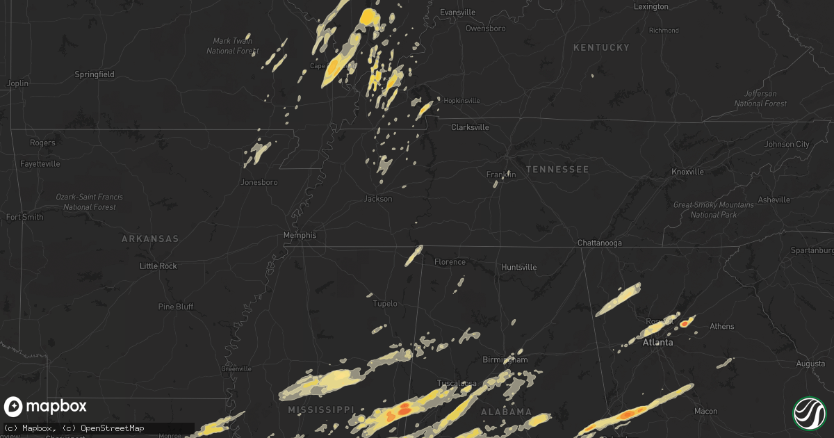
Hail Map in Georgia on April 15, 2011
Get this storm
April 15 map
$229
one time, instant access
Download today. No call, no setup
Keep the $229
Bought the map and want the full workflow? Apply the entire $229 to a subscription within 7 days. None of it is wasted.
Every map, not just this one
This buys you this map. Subscription and you get every map we run, in the markets you choose from a few cities to whole states to nationwide. Plus real-time alerts the moment a storm fires.
Contact data
Name, contact info, occupancy, even credit band for addresses in the footprint. You go from where it hit to who to call.
Become the source they trust
Unlimited branding weather history reports on demand. You already have the documented answer ready for the property owner, and you are the one who showed up with it.
Property data and RoofTrace estimates
Pull up any address you have got, its value and the exact code rules for that jurisdiction, straight from One Click Code. Then RoofTrace estimates the squares, pitch, and roof value, priced the way you price.
Storm reports in Georgia
Georgia
| Date | Description |
|---|---|
| 04/15/20116:57 PM CDT | A local report indicates 1.00 inch wind near 2 E PINE MOUNTAIN VALLE |
| 04/15/20116:57 PM CDT | A local report indicates 1.00 inch wind near 2 E PINE MOUNTAIN |
| 04/15/20116:55 PM CDT | Trees crashing down |
| 04/15/20116:54 PM CDT | A couple of trees down |
| 04/15/20116:51 PM CDT | A local report indicates 1.00 inch wind near 2 S SMYRNA |
| 04/15/20116:50 PM CDT | A nws storm survey team determined that a brief tornado touched down 5 miles sse of hamilton in harris county. There were about 10 trees with clipped canopies along wit |
| 04/15/20116:44 PM CDT | Cobb county 911 relayed a report of county wide tree damage and power lines down. |
| 04/15/20116:44 PM CDT | A local report indicates 2.75 inch wind near HAMILTON |
| 04/15/20116:42 PM CDT | Harris county relayed a report of trees down across the county. |
| 04/15/20116:35 PM CDT | Hail broke windshield of car. |
| 04/15/20116:30 PM CDT | Harris county 911 relayed a report of numerous trees down in eastern harris county. Tree damage started near highway 185 exit 19 and continued east. |
| 04/15/20116:28 PM CDT | Douglas county ema relayed a report of a building with its roof torn off. |
| 04/15/20116:21 PM CDT | Douglas county 911 relayed a report that the roof of a business collapsed in downtown douglasville. Dispatcher reported that collapse was caused by wind. 911 also state |
| 04/15/20116:00 PM CDT | Several trees down. |
| 04/15/20115:40 PM CDT | Several trees down. |
| 04/15/20115:37 PM CDT | Murray county 911 relayed a report of a tree down north of eton. |
| 04/15/20115:35 PM CDT | Ema relayed a report of a few trees down across southeast union county. |
| 04/15/20115:30 PM CDT | Several trees down. |
| 04/15/20115:30 PM CDT | Several trees down. |
| 04/15/20115:00 PM CDT | 15-20 trees down across the southern end of the county. |
| 04/15/20114:15 PM CDT | A local report indicates 1.25 inch wind near SONORAVILLE |
| 04/15/20114:15 PM CDT | Trees on house and powerline |
| 04/15/20114:15 PM CDT | A local report indicates 1.25 inch wind near JASPER |
| 04/15/20114:11 PM CDT | Gordon county ema relayed a report of widespread tree damage along with some downed power lines in southeast gordon county. |
| 04/15/20114:02 PM CDT | Bartow county 911 relayed a report of numerous trees down in the adairsville area. |
| 04/15/20113:57 PM CDT | Off duty nws meteorologist reported 60 mph winds at exit 305 on i75. The meteorologist also reported 4 trees down. |
| 04/15/20113:57 PM CDT | Amatuer radio relayed a report of pnig pong size hail near adairsville. |
| 04/15/20113:39 PM CDT | A local report indicates 1.00 inch wind near 2 E ROME |
| 04/15/20113:34 PM CDT | Floyd county ema relayed a report of quarter sized hail in rome. Damage to cars has been reported. |
| 04/15/20113:33 PM CDT | A nws storm survey team determined that straight line winds with speeds up to 80 mph hit the rome area. 50 to 100 trees were reported down in the area. Damage was conta |
| 04/15/20115:22 AM CDT | One power line down. |
| 04/15/20115:20 AM CDT | Few trees down. |
| 04/15/20115:10 AM CDT | One tree down on hwy 87. |
| 04/15/20115:02 AM CDT | A nws storm survey team determined that a ef1 tornado with winds around 110 miles an hour touched down 5 miles nw of macon. The tornado lifted 2.6 miles later around 5 |
| 04/15/20113:50 AM CDT | A nws damage survey team determined that a ef1 tornado touched down in fort benning. Winds were estimated to be around 100 mph. The tornado tore down portions of a dorm |
| 04/15/20113:50 AM CDT | A nws damage survey team determined that a ef1 tornado touched down in fort benning. Winds were estimated to be around 100 mph. The tornado tore down portions of a dorm |
| 04/15/20113:47 AM CDT | A nws damage survey team determined that a ef1 tornado touched down on the east portion of fort benning. Winds were estimated to be around 100 mph. The tornado tore dow |
| 04/15/20113:36 AM CDT | Roof torn off building and cars overturned on fort benning. Damage near 8th division road and old cusseta hwy. Possible tornado. |
| 04/15/20112:37 AM CDT | A nws storm survey team determined that straight line winds caused damage 2 miles ne of fortson in harris county. There was one tree with its top clipped off and 3 hous |
| 04/15/20111:49 AM CDT | Reported at the intersection of kings spring road and south cobb drive. 52 mph wind gust also recorded. |
| 04/15/20111:45 AM CDT | At least 11 trees down...4 on houses. Portion of roof torn off at bj warehouse building on east west connector. |
| 04/15/20111:39 AM CDT | Public reports a sign torn down at a strip mall on cobb parkway in vinings along with a downed tree in a neighboring parking lot. |
| 04/15/20111:30 AM CDT | Several trees down. |
| 04/15/20111:30 AM CDT | Several trees down on riley road and highway 5. Roof gave in at 6602 bankhead highway. |
| 04/14/20118:56 PM CDT | Gwinnett county 911 relayed a report of one tree down in the snellville area. |
| 04/14/20118:55 PM CDT | At least six trees twisted and snapped half way up. |
| 04/14/20118:20 PM CDT | Structural fire from lightning...barn...at monroe and butts county line. |
| 04/14/20118:08 PM CDT | Numerous trees down at green forest pkwy. Road closed at so. Cobb dr. And so. Atlanta rd. |
| 04/14/20118:05 PM CDT | A local report indicates 2.75 inch wind near LAWRENCEVILLE |
| 04/14/20118:05 PM CDT | Richmond hill subdivision. |
| 04/14/20117:46 PM CDT | A local report indicates 1.00 inch wind near SUGAR HILL |
| 04/14/20117:45 PM CDT | A local report indicates 1.00 inch wind near 8 E MARIETTA |
| 04/14/20117:15 PM CDT | Near lake shore way...lasting about 10 minutes. |
| 04/14/20117:14 PM CDT | Near riverwood high school |
| 04/14/20117:09 PM CDT | A local report indicates 1.75 inch wind near MANCHESTER |
| 04/14/20117:08 PM CDT | Fulton county ema relayed a report of tree down across the northern and central parts of the county. Also reports that a house has collapsed in the sandy springs area. |
| 04/14/20117:05 PM CDT | At johnson ferry rd. Near fulton-cobb county line. |
All States Impacted by Hail Map on April 15, 2011
Cities Impacted by Hail Map on April 15, 2011
- Ledbetter, KY
- Brookport, IL
- Jonesboro, IL
- McClure, IL
- Wolf Lake, IL
- Anna, IL
- Cape Girardeau, MO
- Scott City, MO
- Carbondale, IL
- Thebes, IL
- Makanda, IL
- Oran, MO
- Cobden, IL
- Chaffee, MO
- Tamms, IL
- Benton, MO
- Annapolis, MO
- Des Arc, MO
- Sawyerville, AL
- Cadiz, KY
- Murray, KY
- Mccomb, MS
- Tylertown, MS
- Jayess, MS
- Summit, MS
- Monroe, GA
- Jemison, AL
- Thorsby, AL
- Clanton, AL
- Vicksburg, MS
- Edwards, MS
- McIntosh, AL
- Tibbie, AL
- Deer Park, AL
- Grove Hill, AL
- Leroy, AL
- Gainestown, AL
- Wagarville, AL
- Sunflower, AL
- Jackson, AL
- Okolona, MS
- Perryville, MO
- West Paducah, KY
- Metropolis, IL
- Kevil, KY
- Porterville, MS
- Aliceville, AL
- Scooba, MS
- De Kalb, MS
- Emelle, AL
- Macon, MS
- Kilbourne, IL
- Bath, IL
- Sterrett, AL
- Columbiana, AL
- Wilsonville, AL
- Harpersville, AL
- Chelsea, AL
- Sullivan, MO
- Greensboro, GA
- Brookhaven, MS
- Trussville, AL
- Atlanta, GA
- Marietta, GA
- Greenville, AL
- Chandlerville, IL
- Petersburg, IL
- Ashland, IL
- Pleasant Plains, IL
- Tallula, IL
- Orrville, AL
- Marion Junction, AL
- Safford, AL
- Selma, AL
- Louisiana, MO
- Bowling Green, MO
- Tamaroa, IL
- Pinckneyville, IL
- Modesto, IL
- Waverly, IL
- Franklin, IL
- Hamilton, GA
- Pine Mountain Valley, GA
- Saint Louis, MO
- Starkville, MS
- West Point, MS
- Columbus, MS
- Mount Vernon, AL
- New London, MO
- Hannibal, MO
- Freeman Spur, IL
- Johnston City, IL
- Benton, IL
- Mulkeytown, IL
- Christopher, IL
- West Frankfort, IL
- Herrin, IL
- Zeigler, IL
- Buckner, IL
- Orient, IL
- Royalton, IL
- Peterman, AL
- Monroeville, AL
- Gloster, MS
- Pachuta, MS
- Stonewall, MS
- Quitman, MS
- Shubuta, MS
- Enterprise, MS
- Colchester, IL
- Tennessee, IL
- Calvert City, KY
- Virden, IL
- Morris Chapel, TN
- Villa Rica, GA
- Pinola, MS
- Mendenhall, MS
- Butler, AL
- Jachin, AL
- Alpharetta, GA
- Cumming, GA
- Austell, GA
- Roswell, GA
- Smyrna, GA
- Mableton, GA
- Suwanee, GA
- Duluth, GA
- Peachtree Corners, GA
- Waynesboro, MS
- McCool, MS
- French Camp, MS
- Ethel, MS
- Stewart, MS
- Kilmichael, MS
- Weir, MS
- Daleville, AL
- Ackerman, MS
- Vernon, AL
- Sulligent, AL
- Millport, AL
- Ava, IL
- Campbell Hill, IL
- Williamsville, MO
- Sweet Water, AL
- Pennington, AL
- Union, MS
- Angie, LA
- Lumberton, MS
- Franklinton, LA
- Purvis, MS
- Brooklyn, MS
- Hattiesburg, MS
- Poplarville, MS
- Forsyth, GA
- Barnesville, GA
- Carrier Mills, IL
- Harrisburg, IL
- Marquand, MO
- Greenville, MO
- Lodi, MO
- Fredericktown, MO
- Silva, MO
- Little Rock, MS
- Forest, MS
- Bruceton, TN
- Houston, MS
- Eolia, MO
- Baton Rouge, LA
- Sunshine, LA
- Saint Gabriel, LA
- Palmyra, IL
- Bunker Hill, IL
- Dorsey, IL
- Shipman, IL
- Greenfield, TN
- West, MS
- Durant, MS
- Lexington, MS
- Beaufort, MO
- Kinston, AL
- Samson, AL
- Wesson, MS
- Hazlehurst, MS
- Braxton, MS
- Magee, MS
- Salem, KY
- Burna, KY
- Coffeeville, AL
- State Line, MS
- Millry, AL
- Chatom, AL
- Richton, MS
- Frankville, AL
- Fruitdale, AL
- Neely, MS
- Fort Deposit, AL
- Beaumont, MS
- Vinegar Bend, AL
- Vredenburgh, AL
- Franklin, AL
- Beatrice, AL
- Frisco City, AL
- Kentwood, LA
- Mount Hermon, LA
- Pine Apple, AL
- McLain, MS
- Whatley, AL
- Leakesville, MS
- Greensburg, LA
- Forest Home, AL
- New Augusta, MS
- Tiline, KY
- Smithland, KY
- Dacula, GA
- Auburn, GA
- Lawrenceville, GA
- Hoschton, GA
- Buford, GA
- Raleigh, MS
- Louin, MS
- Thomasville, GA
- Tallahassee, FL
- Cairo, GA
- Havana, FL
- Marion, IL
- Creal Springs, IL
- Saint Francisville, LA
- Glenarm, IL
- Pawnee, IL
- Springfield, IL
- Birmingham, AL
- Smithdale, MS
- Seminary, MS
- Sumrall, MS
- Columbia, MS
- Moselle, MS
- Woodville, MS
- Monterey, LA
- Magnolia, MS
- Foxworth, MS
- Kokomo, MS
- Centreville, MS
- Ruth, MS
- Ellisville, MS
- Bassfield, MS
- Liberty, MS
- Ranger, GA
- Hermanville, MS
- Crystal Springs, MS
- Pattison, MS
- Silex, MO
- Frohna, MO
- Natchez, MS
- Fayette, MS
- Sardis, AL
- Fancy Farm, KY
- Cunningham, KY
- Melber, KY
- Monroe City, MO
- Palmyra, MO
- Saint Charles, MO
- Grafton, IL
- Brussels, IL
- Portage Des Sioux, MO
- Opp, AL
- Andalusia, AL
- Elba, AL
- Lindale, GA
- Rome, GA
- Silver Creek, GA
- Carthage, MS
- Wickliffe, KY
- Brewton, AL
- Cottondale, AL
- Meridian, MS
- Toomsuba, MS
- Chunky, MS
- Florence, MS
- Hickory, MS
- Marion, MS
- Decatur, MS
- Lake, MS
- Morton, MS
- Pulaski, MS
- Brandon, MS
- Newton, MS
- Lawrence, MS
- Auburn, AL
- Auburn University, AL
- Opelika, AL
- Thomaston, AL
- Faunsdale, AL
- Liverpool, IL
- Canton, IL
- Topeka, IL
- Lewistown, IL
- Hunnewell, MO
- Bogalusa, LA
- Monticello, FL
- Maryland Heights, MO
- Marthasville, MO
- Union, MO
- Washington, MO
- Augusta, MO
- Breaux Bridge, LA
- Saint Martinville, LA
- Chatham, IL
- Divernon, IL
- Plaucheville, LA
- Boligee, AL
- Bailey, MS
- Daleville, MS
- Philadelphia, MS
- Collinsville, MS
- Buckatunna, MS
- Pine Mountain, GA
- Warm Springs, GA
- Manchester, GA
- West Point, GA
- Shiloh, GA
- Sharon, TN
- Loganville, GA
- Rayville, LA
- Fosters, AL
- Ralph, AL
- Hartford, AL
- East Saint Louis, IL
- Madison, IL
- Granite City, IL
- Hayneville, AL
- Tyler, AL
- Blountsville, AL
- Hayden, AL
- Edinburg, IL
- Adairsville, GA
- Cartersville, GA
- Kingston, GA
- Fairmount, GA
- White, GA
- Calhoun, GA
- Cave Spring, GA
- Rydal, GA
- Middletown, MO
- Cedartown, GA
- Paulding, MS
- Plaquemine, LA
- Grosse Tete, LA
- Port Allen, LA
- Melvin, AL
- Gilbertown, AL
- Taylorsville, MS
- Bay Springs, MS
- Dongola, IL
- Villa Ridge, IL
- Ullin, IL
- Pulaski, IL
- Elmer, LA
- Karnak, IL
- Grand Chain, IL
- Toxey, AL
- Fayette, AL
- Lucedale, MS
- Citronelle, AL
- Jacob, IL
- Gorham, IL
- Saint Ann, MO
- Defiance, MO
- Foristell, MO
- Wentzville, MO
- Lake Saint Louis, MO
- Jackson, MS
- Madison, MS
- Ridgeland, MS
- Franklin, TN
- Valdosta, GA
- Quitman, GA
- Vaiden, MS
- Cantrall, IL
- Lorman, MS
- Union Church, MS
- Broughton, IL
- Hineston, LA
- Sieper, LA
- Alexander, IL
- Vossburg, MS
- Tuskegee, AL
- Mayfield, KY
- Paducah, KY
- Boaz, KY
- Symsonia, KY
- Hickory, KY
- Clinton, LA
- Wilson, LA
- Newhebron, MS
- Georgetown, MS
- Atmore, AL
- Vienna, IL
- Melville, LA
- Bunkie, LA
- Palmetto, LA
- Washington, LA
- Iuka, MS
- Laurel, MS
- Hartford, IL
- Wood River, IL
- East Alton, IL
- Roxana, IL
- Benton, KY
- Hardin, KY
- Equality, AL
- Rockford, AL
- Verbena, AL
- Marbury, AL
- Prattville, AL
- Deatsville, AL
- Titus, AL
- Eclectic, AL
- Wetumpka, AL
- Addis, LA
- Saint Clair, MO
- Golconda, IL
- Eddyville, IL
- Simpson, IL
- Bloomfield, MO
- Puxico, MO
- Dexter, MO
- Lovejoy, IL
- Venice, IL
- Villa Ridge, MO
- Gray Summit, MO
- Pacific, MO
- Caledonia, MS
- Coffee Springs, AL
- Labadie, MO
- Dresden, TN
- Palmersville, TN
- Duncanville, AL
- Knoxville, AL
- Moundville, AL
- Ethel, LA
- Jackson, LA
- Norwood, LA
- Riverton, IL
- Buffalo, IL
- Dawson, IL
- Williamsville, IL
- Ozark, IL
- Pineville, LA
- Center Point, LA
- Effie, LA
- Deville, LA
- Greenview, IL
- Athens, IL
- Camden, AL
- Columbia, IL
- Newellton, LA
- Silas, AL
- Morrisonville, IL
- Hollow Rock, TN
- McKenzie, TN
- Utica, MS
- Terry, MS
- Girard, IL
- Hazelwood, MO
- Bridgeton, MO
- Belknap, IL
- Grantsburg, IL
- Forkland, AL
- Thompsons Station, TN
- Steens, MS
- Goreville, IL
- Pine Hill, AL
- Thomasville, AL
- Kosciusko, MS
- Sallis, MS
- Tchula, MS
- Barlow, KY
- La Center, KY
- Trezevant, TN
- Atwood, TN
- Alto Pass, IL
- Pittsburg, IL
- Energy, IL
- Cambria, IL
- Thompsonville, IL
- Galatia, IL
- Logan, IL
- De Soto, IL
- Carterville, IL
- Pelham, AL
- Minter, AL
- Marion, KY
- Ewing, IL
- Belle Rive, IL
- Coila, MS
- Cruger, MS
- Eutaw, AL
- Batchelor, LA
- Center, MO
- Calera, AL
- Harrisville, MS
- Transylvania, LA
- Lake Providence, LA
- Epps, LA
- Delhi, LA
- Sondheimer, LA
- Pioneer, LA
- Walnut Grove, MS
- Phil Campbell, AL
- Lisman, AL
- Ward, AL
- York, AL
- Demopolis, AL
- Linden, AL
- Jerseyville, IL
- Fieldon, IL
- Kane, IL
- Florala, AL
- Enterprise, AL
- Tallulah, LA
- Earth City, MO
- Greensboro, AL
- Rockbridge, IL
- Rochester, IL
- Plymouth, IL
- Burnsville, MS
- Waterloo, AL
- Jasper, AL
- House Springs, MO
- High Ridge, MO
- Plantersville, AL
- Maplesville, AL
- Marble Hill, MO
- Alabaster, AL
- Helena, AL
- Billingsley, AL
- Salem, AL
- Woodland, GA
- The Rock, GA
- Notasulga, AL
- Meansville, GA
- Valley, AL
- Fortson, GA
- Thomaston, GA
- Molena, GA
- Cusseta, AL
- Cataula, GA
- Attapulgus, GA
- Whigham, GA
- Bellamy, AL
- Livingston, AL
- Carrollton, GA
- Raymond, MS
- Arlington, KY
- Hampton, KY
- Conehatta, MS
- Almo, KY
- Medina, TN
- Milan, TN
- Norcross, GA
- Stone Mountain, GA
- Tucker, GA
- Friedheim, MO
- Millersville, MO
- Daisy, MO
- Uniontown, MO
- Oak Ridge, MO
- Leslie, MO
- Cottage Hills, IL
- Alton, IL
- East Carondelet, IL
- Florissant, MO
- Bethalto, IL
- South Roxana, IL
- Zalma, MO
- Pelahatchie, MS
- Lauderdale, MS
- Cuba, AL
- Denham Springs, LA
- Prairieville, LA
- Gallion, AL
- Herod, IL
- Qulin, MO
- Wiggins, MS
- Hope Hull, AL
- Lowndesboro, AL
- Letohatchee, AL
- Evergreen, AL
- Saint Stephens, AL
- Georgetown, LA
- Winnfield, LA
- Caseyville, IL
- Collinsville, IL
- Akron, AL
- Jacksonville, IL
- Hazel, KY
- Shuqualak, MS
- Buhl, AL
- Tuscaloosa, AL
- Epes, AL
- Preston, MS
- Gainesville, AL
- Clinton, MS
- Bolton, MS
- Kinder, LA
- Welsh, LA
- Jennings, LA
- Woodbury, GA
- Greenville, GA
- Chancellor, AL
- Beech Grove, AR
- Delaplaine, AR
- Murrayville, IL
- Little River, AL
- Uriah, AL
- Sylacauga, AL
- Vincent, AL
- Childersburg, AL
- Eatonton, GA
- Booneville, MS
- Quincy, FL
- Chattahoochee, FL
- Belleview, MO
- Lettsworth, LA
- Simmesport, LA
- O'Fallon, MO
- Robertsville, MO
- Marion, AL
- Douglasville, GA
- Evangeline, LA
- Aberdeen, MS
- Bradford, TN
- Lena, MS
- Needham, AL
- Naylor, MO
- Rose Hill, MS
- McLeansboro, IL
- Belzoni, MS
- Goodman, MS
- Louisville, MS
- Yazoo City, MS
- Mississippi State, MS
- Sturgis, MS
- Dittmer, MO
- Eupora, MS
- Plainville, GA
- Bainbridge, GA
- Bessemer, AL
- West Blocton, AL
- Russellville, AL
- Rockwood, IL
- Altenburg, MO
- Jackson, MO
- Cutler, IL
- Crosby, MS
- Brent, AL
- Woodstock, AL
- Catherine, AL
- Heidelberg, MS
- McCalla, AL
- Vidalia, LA
- Newbern, AL
- Montevallo, AL
- Mize, MS
- Uniontown, AL
- Jones, AL
- Centreville, AL
- Vance, AL
- Ovett, MS
- Brierfield, AL
- Autaugaville, AL
- Corning, AR
- Marksville, LA
- Winston, GA
- Cairo, IL
- Miller City, IL
- Pocahontas, AR
- Grubville, MO
- Cedar Hill, MO
- Medora, IL
- Martin, TN
- Fulton, KY
- South Fulton, TN
- Nauvoo, AL
- Berry, AL
- Townley, AL
- Carbon Hill, AL
- Oakman, AL
- Vaughan, MS
- Slocomb, AL
- Newton, AL
- Geneva, AL
- New Brockton, AL
- Canton, MS
- Raleigh, IL
- Macedonia, IL
- Rector, AR
- Wright City, MO
- Maryville, IL
- Carrollton, IL
- Castleberry, AL
- Repton, AL
- Clinton, KY
- Slaughter, LA
- Iota, LA
- Egan, LA
- Crowley, LA
- Ballwin, MO
- Oakford, IL
- Buncombe, IL
- Mount Hope, AL
- Town Creek, AL
- Peach Orchard, AR
- Fenton, MO
- Leesville, LA
- Otis, LA
- New Berlin, IL
- Stockton, AL
- Eureka, MO
- New Burnside, IL
- Stonefort, IL
- Gleason, TN
- Henry, TN
- Paris, TN
- Alpine, AL
- Flovilla, GA
- Pearl, MS
- Flomaton, AL
- Hamilton, MS
- Waverly Hall, GA
- White Hall, IL
- Roodhouse, IL
- Fisk, MO
- Broseley, MO
- Knobel, AR
- Paragould, AR
- Bono, AR
- Dyer, TN
- Rutherford, TN
- Hettick, IL
- Greenfield, IL
- Fort Rucker, AL
- De Soto, MO
- Festus, MO
- Farmersville, IL
- Sedalia, KY
- Harvel, IL
- Elsah, IL
- Dow, IL
- Junction, IL
- Ridgway, IL
- Luebbering, MO
- Richwoods, MO
- Beaverton, AL
- Farrar, MO
- Ecru, MS
- Pontotoc, MS
- Blue Springs, MS
- Trenton, TN
- Cave In Rock, IL
- Elizabethtown, IL
- Hardin, IL
- Batchtown, IL
- Mansfield, TN
- Carlinville, IL
- Bankston, AL
- Poplar Bluff, MO
- Table Grove, IL
- Golden Eagle, IL
- Hamburg, IL
- Zebulon, GA
- Alexandria, LA
- Shelby, AL
- Kennedy, AL
- Greensburg, KY
- Fort Polk, LA
- Pitkin, LA
- Dry Prong, LA
- Atlanta, LA
- Olla, LA
- Tullos, LA
- Loami, IL
- Powder Springs, GA
- Oberlin, LA
- Madison, GA
- Buckhead, GA
- Warrenton, MO
- Spring Hill, TN
- Wingo, KY
- Buchanan, TN
- Walnut Ridge, AR
- Lexington, TN
- Wildersville, TN
- Clarkdale, GA
- Lithia Springs, GA
- Havana, IL
- Easton, IL
- Hull, IL
- Equality, IL
- Dothan, AL
- Rolling Fork, MS
- Oak Ridge, LA
- Mayersville, MS
- Bardwell, KY
- Edwardsville, IL
- Moro, IL
- Burfordville, MO
- Biggers, AR
- Dudley, MO
- Cottage Grove, TN
- Ironton, MO
- Lilburn, GA
- Gilbert, LA
- Brentwood, TN
- Farmington, KY
- Patterson, MO
- Troy, MO
- Lesterville, MO


