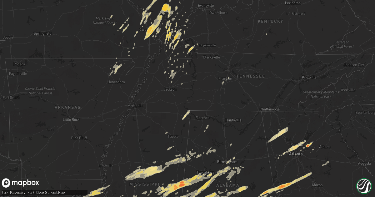
Hail Map in Alabama on April 15, 2011
Get this storm
April 15 map
$229
one time, instant access
Download today. No call, no setup
Keep the $229
Bought the map and want the full workflow? Apply the entire $229 to a subscription within 7 days. None of it is wasted.
Every map, not just this one
This buys you this map. Subscription and you get every map we run, in the markets you choose from a few cities to whole states to nationwide. Plus real-time alerts the moment a storm fires.
Contact data
Name, contact info, occupancy, even credit band for addresses in the footprint. You go from where it hit to who to call.
Become the source they trust
Unlimited branding weather history reports on demand. You already have the documented answer ready for the property owner, and you are the one who showed up with it.
Property data and RoofTrace estimates
Pull up any address you have got, its value and the exact code rules for that jurisdiction, straight from One Click Code. Then RoofTrace estimates the squares, pitch, and roof value, priced the way you price.
Storm reports in Alabama
Alabama
| Date | Description |
|---|---|
| 04/15/20116:39 PM CDT | An ef-2 tornado touched down for the second time near nanafalia. Two dozen homes were significantly damaged due to fallen trees and large sections of roofing material w |
| 04/15/20116:36 PM CDT | Power lines down. Cr 45 closed. |
| 04/15/20116:32 PM CDT | Talladega rescue squad reported a tornado on hwy 77 from talladega fire station. |
| 04/15/20116:27 PM CDT | An ef-2 tornado touched down 2.7 miles north of hamburg just west of county road 45. There was some damage to the roof of a barn and several dozen hard and softwood tre |
| 04/15/20116:25 PM CDT | Roof removed from mobile home. Trees and powerlines down. |
| 04/15/20116:20 PM CDT | Tree down across renfroe road. |
| 04/15/20116:16 PM CDT | Tornado damage reports now coming in from red springs area and ararat road area south of butler. Details sketchy at this time...but damage to buildings indicated. |
| 04/15/20116:00 PM CDT | Roof blown off of a trailer and a tree on a house. Both residences located on broad street. Also reports of trees blown down near county road 5 and 7. |
| 04/15/20115:54 PM CDT | Public reports tornado on hwy 25. |
| 04/15/20115:54 PM CDT | University drive |
| 04/15/20115:53 PM CDT | Damage to the fire station. |
| 04/15/20115:50 PM CDT | Public reports tornado on hwy 25. Media reported trees down. |
| 04/15/20115:50 PM CDT | Trees down on hwy 25. Multiple trees down south of little hope rd completely blocked. Trees down on hwy 82. Tree across road on hwy 5. Friendship road blocked. About 10 |
| 04/15/20115:45 PM CDT | An ef-1 tornado toouched down near on largin road...lifting just north of hwy 25 near lay lake inlet. Several trees were snapped and uprooted and there was roof damage |
| 04/15/20115:45 PM CDT | Bethlehem church off of hwy 27 has been destroyed. Only one wall and the podium remain standing. The building was not occupied at the time of the storm. |
| 04/15/20115:40 PM CDT | An ef-1 tornado touched down for a second time near pinhook. The tornado touched down near state highway 28...right at the chickasaw bogue...or 2 miles northwest of lin |
| 04/15/20115:36 PM CDT | An ef-2 tornado touchdown near dayton. The most concentrated damage occured to several homes that had significant roof damage. There were several hundred hard and softw |
| 04/15/20115:30 PM CDT | Tree on house on ragland road. Power line down on hwy 82 and line down on ragland road. Trees down on house on eoline road. Tree down on house on truman aldrich. |
| 04/15/20115:30 PM CDT | A local report indicates 1.00 inch wind near CHELSEA |
| 04/15/20115:30 PM CDT | Skywarn spotter sees large debris field around tornado. Tornado just east of the riley crossing area. |
| 04/15/20115:27 PM CDT | Damage to siding on fire station building. |
| 04/15/20115:25 PM CDT | Nickle to quarter size hail reported in the scottsdale subdivision. |
| 04/15/20115:25 PM CDT | Nickle to quarter size hail reported in the scottsville subdivision. |
| 04/15/20115:22 PM CDT | An ef-2 tornado touched down near pinhook.the majority of damage sustained was to hard and softwood trees being snapped and uprooted. One brick home had the entire roof |
| 04/15/20115:20 PM CDT | Quarter size hail off cr 52 in deering downs subdivision. |
| 04/15/20115:17 PM CDT | A local report indicates 2.50 inch wind near 2 NW HALF ACRE |
| 04/15/20115:17 PM CDT | A local report indicates 1.00 inch wind near PELHAM |
| 04/15/20115:17 PM CDT | A local report indicates 2.75 inch wind near MYRTLEWOOD |
| 04/15/20115:15 PM CDT | Church completely destroyed on robinson creek road. |
| 04/15/20115:10 PM CDT | Quarter size hail in alabaster. |
| 04/15/20115:05 PM CDT | Possible tornado. 20 to 25 homes damaged. Roads closed due to major damage north of greensboro. Several hundred trees down in the county. |
| 04/15/20115:00 PM CDT | A local report indicates 4.25 inch wind near MYRTLEWOOD |
| 04/15/20115:00 PM CDT | Trees down on a couple of homes along hwy 31 near the fire station. |
| 04/15/20115:00 PM CDT | Trees down on a couple of homes along near 8th street sw near the fire station. Law enforcement witnessed the tornado. |
| 04/15/20114:59 PM CDT | An ef-0 tornado touched down in alabaster near evangel church on thompson rd lifting a few minutes later near city hall on hwy 31. Several trees were knocked down...som |
| 04/15/20114:58 PM CDT | Large magnolia tree down along al hwy 150 near the hoover met. |
| 04/15/20114:55 PM CDT | Baseball size hail caused damage to the georgia pacific plant. Winds and sunroofs were busted out of cars in the area. |
| 04/15/20114:50 PM CDT | Quarter size hail in rocky ridge at jct hwys 17 and 58. |
| 04/15/20114:45 PM CDT | Tornado on the ground crossed hwy 43 5 miles north of demopolis. Numerous large trees down and hwy 43 is blocked. |
| 04/15/20114:44 PM CDT | An ef-2 tornado touched down the tornado touched down about 2.2 miles east of forkland along county road 20. The tornado mainly traveled in forest land snapping and upr |
| 04/15/20114:44 PM CDT | Numerous trees and power lines reported down. |
| 04/15/20114:40 PM CDT | A local report indicates 1.00 inch wind near W VERNON |
| 04/15/20114:38 PM CDT | A local report indicates 1.00 inch wind near W VERNON |
| 04/15/20114:38 PM CDT | Very large hail knocked the windshields out of cars. |
| 04/15/20114:38 PM CDT | Numerous trees down on hwy 5. |
| 04/15/20114:35 PM CDT | Tornado produced major structural damage to residence. |
| 04/15/20114:24 PM CDT | Lines and trees snapped and shredded. Hwy 82 blocked. |
| 04/15/20114:24 PM CDT | Multiple structural damge in magnolia area and south ridge. |
| 04/15/20114:23 PM CDT | Trees and powerlines down on hwy 82. |
| 04/15/20114:19 PM CDT | Several trees down and structural damage to homes on loop road in the circlewood baptist church vicinity. Heavy smell of natural gas in the air. |
| 04/15/20114:14 PM CDT | Trees down on hwy 25. Multiple trees down south of little hope rd completely blocked. Trees down on hwy 82. Tree across road on hwy 5. Friendship road blocked. About 10 |
| 04/15/20114:12 PM CDT | Damage at the tokyo restaurant on 69 south. Several trailer homes at a dealership turned over and speedy oil change north of dealership was heavily damaged. On 82 sever |
| 04/15/20114:05 PM CDT | Stuctural damage to several homes in the beach hill area. |
| 04/15/20114:03 PM CDT | Hwy 80 not passable. |
| 04/15/20114:03 PM CDT | Hwy 80 not passable. A few dozen trees were down along a path several miles long. Trees down on highway 17 and cr 13. Trees down in cuba. |
| 04/15/20114:03 PM CDT | Structural damage to skyland park area. Trees down. Houses impacted on 10th avenue east. |
| 04/15/20113:59 PM CDT | An ef-1 tornado touched down along state highway 25...3 miles west of county road 16...where thousands of trees were snapped and uprooted along the path. There was some |
| 04/15/20113:58 PM CDT | An ef-2 tornado touched down near us highway 80 around mile marker 3 moving northeast to near 7 miles south of livingston. Several hundred hard and softwood trees were |
| 04/15/20113:56 PM CDT | Roofs off of houses |
| 04/15/20113:48 PM CDT | Tornado crossed rte 69 and cr 53...trees down or snapped...power lines dow. |
| 04/15/20113:48 PM CDT | Tornado crossed rte 69 and cr 53...trees down or snapped...power lines dow. |
| 04/15/20113:45 PM CDT | Public reports tornado on the ground crossing highway 25 north of greensboro. At least 50 homes damaged and 10 destroyed per ema. |
| 04/15/20113:42 PM CDT | Stuctural damage to several homes in the beach hill area. |
| 04/15/20113:42 PM CDT | Roofs off of houses north of greensboro. |
| 04/15/20113:39 PM CDT | Tree down on power line |
| 04/15/20113:39 PM CDT | Damage at the tokyo restaurant on 69 south. Several trailer homes at a dealership turned over and speedy oil change north of dealership was heavily damaged. On 82 sever |
| 04/15/20113:38 PM CDT | Old daycare center on hwy 69 south recieved major structual damage. Hillcrest center recieved structural damage to signs. |
| 04/15/20113:36 PM CDT | Tuscaloosa fire department reported tornado on the ground on hwy 69 south near shelton state with debris on roadway. |
| 04/15/20113:31 PM CDT | An ef-2 tornado touched down near state highway 14 and lifted near state highway 69. There were no known injuries...but one person was trapped in an overturned mobile h |
| 04/15/20113:16 PM CDT | An ef-3 tornado touched down near ralph in northeast greene county and moved northeast to near 1.5 miles east of university mall in tuscaloosa. Hundreds of trees were s |
| 04/15/20113:03 PM CDT | An ef-2 tornado touched down south of state route 116...six miles west southwest of gainesville...and moved east to near state route 39...one mile south of gainsville. |
| 04/15/20113:00 PM CDT | Ema reported large tree down which fell on house and did extensive damage to a pickup truck. |
| 04/15/20112:45 PM CDT | *** 1 inj *** probable tornado. Tree collapsed roof and ceiling of home pinning elderly woman. Transported to hospital with unknown injuries. |
| 04/15/20112:06 PM CDT | Cuba vfd reports numerous trees down and blocking old bodka road in emelle. Winds estimated 90 mph. |
| 04/15/20112:05 PM CDT | A tree fell on a home at 309 east spruce street in jackson al. |
| 04/15/20112:03 PM CDT | Cuba vfd reports many trees down in the geiger area... Possible tornado. |
| 04/15/20112:00 PM CDT | Home damaged and mobile home destroyed on dan mitchell rd and mobile home destroyed on hwy 39 |
| 04/15/20111:56 PM CDT | Cuba vfd reports numerous trees down and blocking old bodka road near geiger. Winds estimated 90 mph. |
| 04/15/20111:56 PM CDT | Cuba vfd reports numerous trees down and blocking old bodka road near geiger. Winds estimated 90 mph. |
| 04/15/20111:55 PM CDT | Several homes demolished and multiple homes damaged on payne street...old baxter road...kirkland ave...and martin luther king circle. |
| 04/15/20111:50 PM CDT | Tree falling on home caused roof and ceiling to collapse...pinning home owner. |
| 04/15/20111:48 PM CDT | An ef-2 tornado started one mile west southwest of geiger and moves east northeast to near the tombigbee river. One house was destroyed. At its widest...the path was a |
| 04/15/20111:45 PM CDT | An ef-3 tornado continued from kemper county ms moving just south of geiger traveling east northeast to near the tombigbee river. One house was destroyed others were da |
| 04/15/20111:18 PM CDT | Trees doww 3 wsw of freetown. Possible tornado. |
| 04/15/201112:35 PM CDT | Trees down. Tornado seen on the ground by law enforcement. |
| 04/15/201112:34 PM CDT | Quarter size hail along hwy 49. |
| 04/15/201112:30 PM CDT | Few trees down from fern bank to hightogy. |
| 04/15/201112:15 PM CDT | An ef-1 tornado touched down near nanafalia. This small damage path consisted of mainly tree damage...however...the damage path was completely obscured by the nanafalia |
| 04/15/201112:08 PM CDT | Tornado crossed state road 17 near yarbo. Several large trees down. |
| 04/15/201112:05 PM CDT | Golf ball size hail reported. |
| 04/15/201111:56 AM CDT | Large tree down atop a manufactured home. 3 people trapped inside but no reports of injuries at this time. |
| 04/15/201111:51 AM CDT | Report from laton hill area off highway 56 and county road 11. Mobile home completely destroyed. Roof damage to several homes. Numerous trees and power lines down. |
| 04/15/201111:50 AM CDT | Tornado reported in red springs. |
| 04/15/201111:45 AM CDT | Trees reported down and several homes sustained structural damage. |
| 04/15/201111:45 AM CDT | Wood frame house completely destroyed along highway 56. |
| 04/15/201111:14 AM CDT | Tornado damage reported to hunt oil refinery buildings in melvin. Large limbs down. Several trees reported down. |
| 04/15/201111:02 AM CDT | Quarter sized hail in downtown birmingham. |
| 04/15/201111:00 AM CDT | Golfball size hail reported by public. |
| 04/15/201110:37 AM CDT | Large tree down across county road 14 near oakland. |
| 04/15/20112:00 AM CDT | Two residences had minor damage with trees down a power line snapped on county road 20 just off of highway 27 near ewell. |
| 04/15/20112:00 AM CDT | Several trees were blown down with one outbuilding destroyed. |
| 04/15/20111:10 AM CDT | Numerous trees down in andalusia...kiwanis bldg damaged on s. End of town. |
| 04/15/20111:10 AM CDT | Emergency manager reports 1/2 mile wide path of damage near the bypass on the south end of andalusia. |
| 04/15/201112:48 AM CDT | One inch hail reported on lindsey bridge rd. In andalusia. |
| 04/15/201112:27 AM CDT | Large tree fell on home. |
| 04/15/201112:13 AM CDT | Signs in a shopping center blown down in the wadley area. |
| 04/15/201112:10 AM CDT | Tree down on a home with occupants trapped inside at 5416 damascus rd. Vfd working to free occupants. |
| 04/14/201111:55 PM CDT | Trees down along sherling lake rd. North of greenville. Other trees down in area and around the county. |
| 04/14/201111:50 PM CDT | Multiple homes and other structures reported damaged on and near hwy 31 north of brewton near the county line. |
| 04/14/201111:45 PM CDT | Trees and powerlines down near hwy 31. |
| 04/14/201111:45 PM CDT | Trees and powerlines down near hwy 31. |
| 04/14/201111:42 PM CDT | An ef-1 tornado touched down in a wooded area on the east side of lake martin...or 4 miles southwest of jacksons gap. Most of the damage consisted of uprooted and snapp |
| 04/14/201111:40 PM CDT | Numerous trees down in and around wind creek state park. Possible tornado. |
| 04/14/201111:30 PM CDT | Trees down on wildfork rd. In barnett crossroads and in the appleton community. |
| 04/14/201111:25 PM CDT | Significant structure damage near the weoka community one mile south of the county line between state hwy 231 and 9. |
| 04/14/201111:17 PM CDT | An ef-2 tornado touched down 6.4 miles west of central along county road 334 in northern elmore county.the tornado traveled northeast crossing state highway 9 in southe |
| 04/14/201110:50 PM CDT | Windows broken...porches torn...and trees down in mobile home park on cr94. |
| 04/14/201110:49 PM CDT | Trees down and home damaged at cr 57 south of cr 49. |
| 04/14/201110:40 PM CDT | A tree was knocked down along county road 671. |
| 04/14/201110:26 PM CDT | Trees and power line down at highway 21 and 47 just east of beatrice. Beatrice is without power. Probable tornado. |
| 04/14/201110:07 PM CDT | Mobile ema reports roofs off homes and mobile homes damaged. Large trees and power lines down across roads. No known inuries at this time. |
| 04/14/20119:35 PM CDT | 25 trees down at cr9 and al14 w. |
| 04/14/20119:34 PM CDT | An ef-1 tornado was surveyed near mulberry. The tornado touched down near highway 14 and lifted northeast of cr 9. Several dozen hardwood trees were uprooted. The torna |
| 04/14/20119:32 PM CDT | A tree was knocked down at the intersection of highway 75 and highway 40. |
| 04/14/20119:28 PM CDT | An ef-0 tornado touched down just west of grays ferry rd...0.7 miles northeast of titus. From there it traveled northeast crossing grays ferry road lifting in a wooded |
| 04/14/20119:25 PM CDT | *** 1 inj *** multiple homes destroyed. Multiple homes have moderate to severe damage. 1 injury...transported to hospital. Multiple trees and power lines down. |
| 04/14/20119:15 PM CDT | Trees down at cr56 and cr43. Possible tornado. |
| 04/14/20118:50 PM CDT | Trees down at hwy 82 and cr 40 in independence. Possible tornado. |
| 04/14/20118:15 PM CDT | *** 1 inj *** unknown number of injuries in vinegar bend and deer park areas reported by both ema and media. Trees blocking roads and preventing emergency crews from re |
| 04/14/20118:13 PM CDT | An ef-1 tornado touched down west of selma and just south of highway 22 traveling northeast to wildwood dr. The brief damage included soft and hardwood trees snapped an |
| 04/14/20118:12 PM CDT | Downtown selma |
| 04/14/20117:48 PM CDT | An ef-1 tornado touched down north of marion junction along county road 58 traveling northeast to county road 944. Heavy damage was sustained to the roof and walls of a |
| 04/14/20117:26 PM CDT | Tree down on ballard road. |
| 04/14/20117:05 PM CDT | An ef-1 tornado briefly touched down along county road 272 uprooting several soft and hardwood trees. Significant damage was sustained to a mobile home from uprooted tr |
| 04/14/20117:05 PM CDT | Trees down and blocking sr 22. |
| 04/14/20117:00 PM CDT | Spotter observed 75 mph winds on a hand held anemometer 1 mile southeast of suttle...with several trees down. |
All States Impacted by Hail Map on April 15, 2011
Cities Impacted by Hail Map on April 15, 2011
- Ledbetter, KY
- Brookport, IL
- Jonesboro, IL
- McClure, IL
- Wolf Lake, IL
- Anna, IL
- Cape Girardeau, MO
- Scott City, MO
- Carbondale, IL
- Thebes, IL
- Makanda, IL
- Oran, MO
- Cobden, IL
- Chaffee, MO
- Tamms, IL
- Benton, MO
- Annapolis, MO
- Des Arc, MO
- Sawyerville, AL
- Cadiz, KY
- Murray, KY
- Mccomb, MS
- Tylertown, MS
- Jayess, MS
- Summit, MS
- Monroe, GA
- Jemison, AL
- Thorsby, AL
- Clanton, AL
- Vicksburg, MS
- Edwards, MS
- McIntosh, AL
- Tibbie, AL
- Deer Park, AL
- Grove Hill, AL
- Leroy, AL
- Gainestown, AL
- Wagarville, AL
- Sunflower, AL
- Jackson, AL
- Okolona, MS
- Perryville, MO
- West Paducah, KY
- Metropolis, IL
- Kevil, KY
- Porterville, MS
- Aliceville, AL
- Scooba, MS
- De Kalb, MS
- Emelle, AL
- Macon, MS
- Kilbourne, IL
- Bath, IL
- Sterrett, AL
- Columbiana, AL
- Wilsonville, AL
- Harpersville, AL
- Chelsea, AL
- Sullivan, MO
- Greensboro, GA
- Brookhaven, MS
- Trussville, AL
- Atlanta, GA
- Marietta, GA
- Greenville, AL
- Chandlerville, IL
- Petersburg, IL
- Ashland, IL
- Pleasant Plains, IL
- Tallula, IL
- Orrville, AL
- Marion Junction, AL
- Safford, AL
- Selma, AL
- Louisiana, MO
- Bowling Green, MO
- Tamaroa, IL
- Pinckneyville, IL
- Modesto, IL
- Waverly, IL
- Franklin, IL
- Hamilton, GA
- Pine Mountain Valley, GA
- Saint Louis, MO
- Starkville, MS
- West Point, MS
- Columbus, MS
- Mount Vernon, AL
- New London, MO
- Hannibal, MO
- Freeman Spur, IL
- Johnston City, IL
- Benton, IL
- Mulkeytown, IL
- Christopher, IL
- West Frankfort, IL
- Herrin, IL
- Zeigler, IL
- Buckner, IL
- Orient, IL
- Royalton, IL
- Peterman, AL
- Monroeville, AL
- Gloster, MS
- Pachuta, MS
- Stonewall, MS
- Quitman, MS
- Shubuta, MS
- Enterprise, MS
- Colchester, IL
- Tennessee, IL
- Calvert City, KY
- Virden, IL
- Morris Chapel, TN
- Villa Rica, GA
- Pinola, MS
- Mendenhall, MS
- Butler, AL
- Jachin, AL
- Alpharetta, GA
- Cumming, GA
- Austell, GA
- Roswell, GA
- Smyrna, GA
- Mableton, GA
- Suwanee, GA
- Duluth, GA
- Peachtree Corners, GA
- Waynesboro, MS
- McCool, MS
- French Camp, MS
- Ethel, MS
- Stewart, MS
- Kilmichael, MS
- Weir, MS
- Daleville, AL
- Ackerman, MS
- Vernon, AL
- Sulligent, AL
- Millport, AL
- Ava, IL
- Campbell Hill, IL
- Williamsville, MO
- Sweet Water, AL
- Pennington, AL
- Union, MS
- Angie, LA
- Lumberton, MS
- Franklinton, LA
- Purvis, MS
- Brooklyn, MS
- Hattiesburg, MS
- Poplarville, MS
- Forsyth, GA
- Barnesville, GA
- Carrier Mills, IL
- Harrisburg, IL
- Marquand, MO
- Greenville, MO
- Lodi, MO
- Fredericktown, MO
- Silva, MO
- Little Rock, MS
- Forest, MS
- Bruceton, TN
- Houston, MS
- Eolia, MO
- Baton Rouge, LA
- Sunshine, LA
- Saint Gabriel, LA
- Palmyra, IL
- Bunker Hill, IL
- Dorsey, IL
- Shipman, IL
- Greenfield, TN
- West, MS
- Durant, MS
- Lexington, MS
- Beaufort, MO
- Kinston, AL
- Samson, AL
- Wesson, MS
- Hazlehurst, MS
- Braxton, MS
- Magee, MS
- Salem, KY
- Burna, KY
- Coffeeville, AL
- State Line, MS
- Millry, AL
- Chatom, AL
- Richton, MS
- Frankville, AL
- Fruitdale, AL
- Neely, MS
- Fort Deposit, AL
- Beaumont, MS
- Vinegar Bend, AL
- Vredenburgh, AL
- Franklin, AL
- Beatrice, AL
- Frisco City, AL
- Kentwood, LA
- Mount Hermon, LA
- Pine Apple, AL
- McLain, MS
- Whatley, AL
- Leakesville, MS
- Greensburg, LA
- Forest Home, AL
- New Augusta, MS
- Tiline, KY
- Smithland, KY
- Dacula, GA
- Auburn, GA
- Lawrenceville, GA
- Hoschton, GA
- Buford, GA
- Raleigh, MS
- Louin, MS
- Thomasville, GA
- Tallahassee, FL
- Cairo, GA
- Havana, FL
- Marion, IL
- Creal Springs, IL
- Saint Francisville, LA
- Glenarm, IL
- Pawnee, IL
- Springfield, IL
- Birmingham, AL
- Smithdale, MS
- Seminary, MS
- Sumrall, MS
- Columbia, MS
- Moselle, MS
- Woodville, MS
- Monterey, LA
- Magnolia, MS
- Foxworth, MS
- Kokomo, MS
- Centreville, MS
- Ruth, MS
- Ellisville, MS
- Bassfield, MS
- Liberty, MS
- Ranger, GA
- Hermanville, MS
- Crystal Springs, MS
- Pattison, MS
- Silex, MO
- Frohna, MO
- Natchez, MS
- Fayette, MS
- Sardis, AL
- Fancy Farm, KY
- Cunningham, KY
- Melber, KY
- Monroe City, MO
- Palmyra, MO
- Saint Charles, MO
- Grafton, IL
- Brussels, IL
- Portage Des Sioux, MO
- Opp, AL
- Andalusia, AL
- Elba, AL
- Lindale, GA
- Rome, GA
- Silver Creek, GA
- Carthage, MS
- Wickliffe, KY
- Brewton, AL
- Cottondale, AL
- Meridian, MS
- Toomsuba, MS
- Chunky, MS
- Florence, MS
- Hickory, MS
- Marion, MS
- Decatur, MS
- Lake, MS
- Morton, MS
- Pulaski, MS
- Brandon, MS
- Newton, MS
- Lawrence, MS
- Auburn, AL
- Auburn University, AL
- Opelika, AL
- Thomaston, AL
- Faunsdale, AL
- Liverpool, IL
- Canton, IL
- Topeka, IL
- Lewistown, IL
- Hunnewell, MO
- Bogalusa, LA
- Monticello, FL
- Maryland Heights, MO
- Marthasville, MO
- Union, MO
- Washington, MO
- Augusta, MO
- Breaux Bridge, LA
- Saint Martinville, LA
- Chatham, IL
- Divernon, IL
- Plaucheville, LA
- Boligee, AL
- Bailey, MS
- Daleville, MS
- Philadelphia, MS
- Collinsville, MS
- Buckatunna, MS
- Pine Mountain, GA
- Warm Springs, GA
- Manchester, GA
- West Point, GA
- Shiloh, GA
- Sharon, TN
- Loganville, GA
- Rayville, LA
- Fosters, AL
- Ralph, AL
- Hartford, AL
- East Saint Louis, IL
- Madison, IL
- Granite City, IL
- Hayneville, AL
- Tyler, AL
- Blountsville, AL
- Hayden, AL
- Edinburg, IL
- Adairsville, GA
- Cartersville, GA
- Kingston, GA
- Fairmount, GA
- White, GA
- Calhoun, GA
- Cave Spring, GA
- Rydal, GA
- Middletown, MO
- Cedartown, GA
- Paulding, MS
- Plaquemine, LA
- Grosse Tete, LA
- Port Allen, LA
- Melvin, AL
- Gilbertown, AL
- Taylorsville, MS
- Bay Springs, MS
- Dongola, IL
- Villa Ridge, IL
- Ullin, IL
- Pulaski, IL
- Elmer, LA
- Karnak, IL
- Grand Chain, IL
- Toxey, AL
- Fayette, AL
- Lucedale, MS
- Citronelle, AL
- Jacob, IL
- Gorham, IL
- Saint Ann, MO
- Defiance, MO
- Foristell, MO
- Wentzville, MO
- Lake Saint Louis, MO
- Jackson, MS
- Madison, MS
- Ridgeland, MS
- Franklin, TN
- Valdosta, GA
- Quitman, GA
- Vaiden, MS
- Cantrall, IL
- Lorman, MS
- Union Church, MS
- Broughton, IL
- Hineston, LA
- Sieper, LA
- Alexander, IL
- Vossburg, MS
- Tuskegee, AL
- Mayfield, KY
- Paducah, KY
- Boaz, KY
- Symsonia, KY
- Hickory, KY
- Clinton, LA
- Wilson, LA
- Newhebron, MS
- Georgetown, MS
- Atmore, AL
- Vienna, IL
- Melville, LA
- Bunkie, LA
- Palmetto, LA
- Washington, LA
- Iuka, MS
- Laurel, MS
- Hartford, IL
- Wood River, IL
- East Alton, IL
- Roxana, IL
- Benton, KY
- Hardin, KY
- Equality, AL
- Rockford, AL
- Verbena, AL
- Marbury, AL
- Prattville, AL
- Deatsville, AL
- Titus, AL
- Eclectic, AL
- Wetumpka, AL
- Addis, LA
- Saint Clair, MO
- Golconda, IL
- Eddyville, IL
- Simpson, IL
- Bloomfield, MO
- Puxico, MO
- Dexter, MO
- Lovejoy, IL
- Venice, IL
- Villa Ridge, MO
- Gray Summit, MO
- Pacific, MO
- Caledonia, MS
- Coffee Springs, AL
- Labadie, MO
- Dresden, TN
- Palmersville, TN
- Duncanville, AL
- Knoxville, AL
- Moundville, AL
- Ethel, LA
- Jackson, LA
- Norwood, LA
- Riverton, IL
- Buffalo, IL
- Dawson, IL
- Williamsville, IL
- Ozark, IL
- Pineville, LA
- Center Point, LA
- Effie, LA
- Deville, LA
- Greenview, IL
- Athens, IL
- Camden, AL
- Columbia, IL
- Newellton, LA
- Silas, AL
- Morrisonville, IL
- Hollow Rock, TN
- McKenzie, TN
- Utica, MS
- Terry, MS
- Girard, IL
- Hazelwood, MO
- Bridgeton, MO
- Belknap, IL
- Grantsburg, IL
- Forkland, AL
- Thompsons Station, TN
- Steens, MS
- Goreville, IL
- Pine Hill, AL
- Thomasville, AL
- Kosciusko, MS
- Sallis, MS
- Tchula, MS
- Barlow, KY
- La Center, KY
- Trezevant, TN
- Atwood, TN
- Alto Pass, IL
- Pittsburg, IL
- Energy, IL
- Cambria, IL
- Thompsonville, IL
- Galatia, IL
- Logan, IL
- De Soto, IL
- Carterville, IL
- Pelham, AL
- Minter, AL
- Marion, KY
- Ewing, IL
- Belle Rive, IL
- Coila, MS
- Cruger, MS
- Eutaw, AL
- Batchelor, LA
- Center, MO
- Calera, AL
- Harrisville, MS
- Transylvania, LA
- Lake Providence, LA
- Epps, LA
- Delhi, LA
- Sondheimer, LA
- Pioneer, LA
- Walnut Grove, MS
- Phil Campbell, AL
- Lisman, AL
- Ward, AL
- York, AL
- Demopolis, AL
- Linden, AL
- Jerseyville, IL
- Fieldon, IL
- Kane, IL
- Florala, AL
- Enterprise, AL
- Tallulah, LA
- Earth City, MO
- Greensboro, AL
- Rockbridge, IL
- Rochester, IL
- Plymouth, IL
- Burnsville, MS
- Waterloo, AL
- Jasper, AL
- House Springs, MO
- High Ridge, MO
- Plantersville, AL
- Maplesville, AL
- Marble Hill, MO
- Alabaster, AL
- Helena, AL
- Billingsley, AL
- Salem, AL
- Woodland, GA
- The Rock, GA
- Notasulga, AL
- Meansville, GA
- Valley, AL
- Fortson, GA
- Thomaston, GA
- Molena, GA
- Cusseta, AL
- Cataula, GA
- Attapulgus, GA
- Whigham, GA
- Bellamy, AL
- Livingston, AL
- Carrollton, GA
- Raymond, MS
- Arlington, KY
- Hampton, KY
- Conehatta, MS
- Almo, KY
- Medina, TN
- Milan, TN
- Norcross, GA
- Stone Mountain, GA
- Tucker, GA
- Friedheim, MO
- Millersville, MO
- Daisy, MO
- Uniontown, MO
- Oak Ridge, MO
- Leslie, MO
- Cottage Hills, IL
- Alton, IL
- East Carondelet, IL
- Florissant, MO
- Bethalto, IL
- South Roxana, IL
- Zalma, MO
- Pelahatchie, MS
- Lauderdale, MS
- Cuba, AL
- Denham Springs, LA
- Prairieville, LA
- Gallion, AL
- Herod, IL
- Qulin, MO
- Wiggins, MS
- Hope Hull, AL
- Lowndesboro, AL
- Letohatchee, AL
- Evergreen, AL
- Saint Stephens, AL
- Georgetown, LA
- Winnfield, LA
- Caseyville, IL
- Collinsville, IL
- Akron, AL
- Jacksonville, IL
- Hazel, KY
- Shuqualak, MS
- Buhl, AL
- Tuscaloosa, AL
- Epes, AL
- Preston, MS
- Gainesville, AL
- Clinton, MS
- Bolton, MS
- Kinder, LA
- Welsh, LA
- Jennings, LA
- Woodbury, GA
- Greenville, GA
- Chancellor, AL
- Beech Grove, AR
- Delaplaine, AR
- Murrayville, IL
- Little River, AL
- Uriah, AL
- Sylacauga, AL
- Vincent, AL
- Childersburg, AL
- Eatonton, GA
- Booneville, MS
- Quincy, FL
- Chattahoochee, FL
- Belleview, MO
- Lettsworth, LA
- Simmesport, LA
- O'Fallon, MO
- Robertsville, MO
- Marion, AL
- Douglasville, GA
- Evangeline, LA
- Aberdeen, MS
- Bradford, TN
- Lena, MS
- Needham, AL
- Naylor, MO
- Rose Hill, MS
- McLeansboro, IL
- Belzoni, MS
- Goodman, MS
- Louisville, MS
- Yazoo City, MS
- Mississippi State, MS
- Sturgis, MS
- Dittmer, MO
- Eupora, MS
- Plainville, GA
- Bainbridge, GA
- Bessemer, AL
- West Blocton, AL
- Russellville, AL
- Rockwood, IL
- Altenburg, MO
- Jackson, MO
- Cutler, IL
- Crosby, MS
- Brent, AL
- Woodstock, AL
- Catherine, AL
- Heidelberg, MS
- McCalla, AL
- Vidalia, LA
- Newbern, AL
- Montevallo, AL
- Mize, MS
- Uniontown, AL
- Jones, AL
- Centreville, AL
- Vance, AL
- Ovett, MS
- Brierfield, AL
- Autaugaville, AL
- Corning, AR
- Marksville, LA
- Winston, GA
- Cairo, IL
- Miller City, IL
- Pocahontas, AR
- Grubville, MO
- Cedar Hill, MO
- Medora, IL
- Martin, TN
- Fulton, KY
- South Fulton, TN
- Nauvoo, AL
- Berry, AL
- Townley, AL
- Carbon Hill, AL
- Oakman, AL
- Vaughan, MS
- Slocomb, AL
- Newton, AL
- Geneva, AL
- New Brockton, AL
- Canton, MS
- Raleigh, IL
- Macedonia, IL
- Rector, AR
- Wright City, MO
- Maryville, IL
- Carrollton, IL
- Castleberry, AL
- Repton, AL
- Clinton, KY
- Slaughter, LA
- Iota, LA
- Egan, LA
- Crowley, LA
- Ballwin, MO
- Oakford, IL
- Buncombe, IL
- Mount Hope, AL
- Town Creek, AL
- Peach Orchard, AR
- Fenton, MO
- Leesville, LA
- Otis, LA
- New Berlin, IL
- Stockton, AL
- Eureka, MO
- New Burnside, IL
- Stonefort, IL
- Gleason, TN
- Henry, TN
- Paris, TN
- Alpine, AL
- Flovilla, GA
- Pearl, MS
- Flomaton, AL
- Hamilton, MS
- Waverly Hall, GA
- White Hall, IL
- Roodhouse, IL
- Fisk, MO
- Broseley, MO
- Knobel, AR
- Paragould, AR
- Bono, AR
- Dyer, TN
- Rutherford, TN
- Hettick, IL
- Greenfield, IL
- Fort Rucker, AL
- De Soto, MO
- Festus, MO
- Farmersville, IL
- Sedalia, KY
- Harvel, IL
- Elsah, IL
- Dow, IL
- Junction, IL
- Ridgway, IL
- Luebbering, MO
- Richwoods, MO
- Beaverton, AL
- Farrar, MO
- Ecru, MS
- Pontotoc, MS
- Blue Springs, MS
- Trenton, TN
- Cave In Rock, IL
- Elizabethtown, IL
- Hardin, IL
- Batchtown, IL
- Mansfield, TN
- Carlinville, IL
- Bankston, AL
- Poplar Bluff, MO
- Table Grove, IL
- Golden Eagle, IL
- Hamburg, IL
- Zebulon, GA
- Alexandria, LA
- Shelby, AL
- Kennedy, AL
- Greensburg, KY
- Fort Polk, LA
- Pitkin, LA
- Dry Prong, LA
- Atlanta, LA
- Olla, LA
- Tullos, LA
- Loami, IL
- Powder Springs, GA
- Oberlin, LA
- Madison, GA
- Buckhead, GA
- Warrenton, MO
- Spring Hill, TN
- Wingo, KY
- Buchanan, TN
- Walnut Ridge, AR
- Lexington, TN
- Wildersville, TN
- Clarkdale, GA
- Lithia Springs, GA
- Havana, IL
- Easton, IL
- Hull, IL
- Equality, IL
- Dothan, AL
- Rolling Fork, MS
- Oak Ridge, LA
- Mayersville, MS
- Bardwell, KY
- Edwardsville, IL
- Moro, IL
- Burfordville, MO
- Biggers, AR
- Dudley, MO
- Cottage Grove, TN
- Ironton, MO
- Lilburn, GA
- Gilbert, LA
- Brentwood, TN
- Farmington, KY
- Patterson, MO
- Troy, MO
- Lesterville, MO


