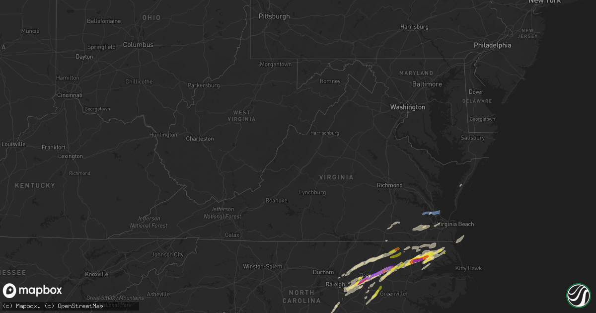
Hail Map in Virginia on April 7, 2022
Get this storm
April 7 map
$229
one time, instant access
Download today. No call, no setup
Keep the $229
Bought the map and want the full workflow? Apply the entire $229 to a subscription within 7 days. None of it is wasted.
Every map, not just this one
This buys you this map. Subscription and you get every map we run, in the markets you choose from a few cities to whole states to nationwide. Plus real-time alerts the moment a storm fires.
Contact data
Name, contact info, occupancy, even credit band for addresses in the footprint. You go from where it hit to who to call.
Become the source they trust
Unlimited branding weather history reports on demand. You already have the documented answer ready for the property owner, and you are the one who showed up with it.
Property data and RoofTrace estimates
Pull up any address you have got, its value and the exact code rules for that jurisdiction, straight from One Click Code. Then RoofTrace estimates the squares, pitch, and roof value, priced the way you price.
Storm reports in Virginia
Virginia
| Date | Description |
|---|---|
| 04/07/20225:44 PM CDT | Mesonet station xodu lafayette river. |
| 04/07/20225:28 PM CDT | Trees down near hampton coliseum. |
| 04/07/20224:45 PM CDT | Tree down. |
| 04/07/20222:06 AM CDT | At 705 PM EDT, severe thunderstorms were located along a line extending from near Fentress to Moyock to Burgess, moving east at 50 mph. HAZARD...Ping pong ball size hail and 60 mph wind gusts. SOURCE...Radar indicated. IMPACT...People and animals outdoors will be injured. Expect hail damage to roofs, siding, windows, and vehicles. Expect wind damage to trees and powerlines. Severe thunderstorms will be near... Princess Anne, Moyock, Back Bay and Fentress around 710 PM EDT. Currituck around 715 PM EDT. Weeksville and Knotts Island around 720 PM EDT. Old Trap and Shiloh around 730 PM EDT. Grandy around 745 PM EDT. Sanderling around 750 PM EDT.Other locations impacted by these severe thunderstorms include PoplarBranch, Spot, Saint Johns, Pungo, Jacocks, Light Nixon Fork, SpencesCorner, Goose Creek, Harvey Point and Taylors Beach. |
| 04/07/20221:12 AM CDT | At 612 PM EDT, severe thunderstorms were located along a line extending from near Holland to 7 miles north of Windsor, moving east at 40 mph. HAZARD...Ping pong ball size hail and 60 mph wind gusts. SOURCE...Radar indicated. IMPACT...People and animals outdoors will be injured. Expect hail damage to roofs, siding, windows, and vehicles. Expect wind damage to trees and powerlines. Severe thunderstorms will be near... Holland and Whaleyville around 615 PM EDT. Colerain around 625 PM EDT. Valhalla and Rockyhock around 630 PM EDT. Tyner around 635 PM EDT. Chesapeake around 640 PM EDT. Belvidere around 645 PM EDT. Hertford and Winfall around 650 PM EDT. Chapanoke around 655 PM EDT.Other locations impacted by these severe thunderstorms include GoosePond, Whites Crossroads, Tunis, Pierceville, Newsome Store, Savage,Arrowhead Beach, Chowan Beach, Topsy and Parkville. |
| 04/07/20221:09 AM CDT | At 608 PM EDT, a severe thunderstorm was located over Windsor, moving east at 35 mph. HAZARD...60 mph wind gusts and quarter size hail. SOURCE...Radar indicated. IMPACT...Minor damage to vehicles is possible. Expect wind damage to trees and powerlines. This severe thunderstorm will be near... Kings Fork around 615 PM EDT. Downtown Suffolk around 620 PM EDT. Suffolk, Driver and Crittenden around 630 PM EDT. Chesapeake, Western Branch and Bowers Hill around 635 PM EDT. Churchland and Deep Creek around 640 PM EDT. Downtown Portsmouth, Old Dominion University, Portsmouth, Ghent and Cradock around 645 PM EDT. Norfolk State University, Downtown Norfolk, Norview and Norfolk NAS around 650 PM EDT. Virginia Wesleyan University, Regent University, Ocean View and Norfolk International around 655 PM EDT.Other locations impacted by this severe thunderstorm include SouthNorfolk, Portlock, Longview, Mount Pleasant, Lummis, Suffolk Airport,Huntersville, Wills Corner, Herberts Corner and Magnolia. |
| 04/07/202212:50 AM CDT | At 550 PM EDT, a severe thunderstorm was located near Ivor, or 8 miles east of Wakefield, moving east at 50 mph. HAZARD...60 mph wind gusts and penny size hail. SOURCE...Radar indicated. IMPACT...Expect damage to trees and powerlines. This severe thunderstorm will be near... Isle Of Wight around 555 PM EDT. Smithfield around 600 PM EDT. Rescue and Fort Eustis around 610 PM EDT. Christopher Newport University, Patrick Henry Field, Beaconsdale and Denbigh around 615 PM EDT. Hampton, Northampton and Tabb around 620 PM EDT. Langley AFB, Hampton University, Buckroe Beach and Fort Monroe around 625 PM EDT. Grand View around 630 PM EDT.Other locations impacted by this severe thunderstorm includeRushmere, Pons, Carrollton, Chippokes State Park, Longview, BennsChurch, Oriana, Bethel Church, Ellis Fork and Hilton Village. |
| 04/07/202212:29 AM CDT | At 529 PM EDT, a severe thunderstorm was located 7 miles southwest of Conway, or 7 miles north of Rich Square, moving northeast at 40 mph. HAZARD...Golf ball size hail and 60 mph wind gusts. SOURCE...Radar indicated. IMPACT...People and animals outdoors will be injured. Expect hail damage to roofs, siding, windows, and vehicles. Expect wind damage to trees and powerlines. This severe thunderstorm will be near... Woodland around 535 PM EDT. Conway around 540 PM EDT. Murfreesboro and Chowan University around 550 PM EDT. Como around 600 PM EDT. Roduco around 610 PM EDT. Holland and Gates around 615 PM EDT.Other locations impacted by this severe thunderstorm includeMilwaukee, Tunis, Menola, Chowan Beach, Topsy, Mapleton, Buckland,Jackson, Dort and Bryantown. |
| 04/07/202212:12 AM CDT | At 511 PM EDT, a severe thunderstorm was located 7 miles east of Jarratt, or 13 miles northeast of Emporia, moving east at 40 mph. HAZARD...60 mph wind gusts and quarter size hail. SOURCE...Radar indicated. IMPACT...Minor damage to vehicles is possible. Expect wind damage to trees and powerlines. This severe thunderstorm will be near... Sussex around 520 PM EDT. Homeville around 530 PM EDT. Wakefield around 545 PM EDT. Ivor, Dendron and Zuni around 550 PM EDT.Other locations impacted by this severe thunderstorm includeVicksville, Booth Fork, Gray, Berlin, Booker, Yale, Lumberton, EllisFork, Manry and Huske. |
| 04/06/202211:52 PM CDT | At 451 PM EDT, a severe thunderstorm was located 8 miles southwest of Halifax, moving east at 55 mph. HAZARD...Golf ball size hail and 60 mph wind gusts. SOURCE...Radar indicated. IMPACT...People and animals outdoors will be injured. Expect hail damage to roofs, siding, windows, and vehicles. Expect wind damage to trees and powerlines. This severe thunderstorm will be near... Woodland around 520 PM EDT. Conway around 525 PM EDT.Other locations impacted by this severe thunderstorm includeEagletown, Mud Castle, Milwaukee, Pendleton, Potecasi, Lasker,Jackson, Bryantown, Boones Crossroads and Pleasant Grove. |
All States Impacted by Hail Map on April 7, 2022
Cities Impacted by Hail Map on April 7, 2022
- Belvidere, NC
- Tyner, NC
- Loris, SC
- Hobbsville, NC
- Colerain, NC
- Harrellsville, NC
- South Mills, NC
- Edenton, NC
- Cofield, NC
- Hertford, NC
- Ahoskie, NC
- Windsor, NC
- Elizabeth City, NC
- Aulander, NC
- Whitakers, NC
- Middlesex, NC
- Spring Hope, NC
- Scotland Neck, NC
- Elm City, NC
- Hobgood, NC
- Battleboro, NC
- Rocky Mount, NC
- Wilson, NC
- Bailey, NC
- Nashville, NC
- Tarboro, NC
- Galivants Ferry, SC
- Yankeetown, FL
- Inglis, FL
- Crystal River, FL
- Green Sea, SC
- Tabor City, NC
- Nichols, SC
- Kenly, NC
- Sims, NC
- Conway, SC
- Aynor, SC
- Hemingway, SC
- Wendell, NC
- Zebulon, NC
- Clayton, NC
- Selma, NC
- Linden, NC
- Fayetteville, NC
- Dunn, NC
- Erwin, NC
- Cuttyhunk, MA
- Fremont, NC
- Clarendon, NC
- Halifax, NC
- Hollister, NC
- Enfield, NC
- Louisburg, NC
- Castalia, NC
- Stantonsburg, NC
- Coats, NC
- Wake Forest, NC
- Rolesville, NC
- Greenville, NC
- Emporia, VA
- Black Creek, NC
- Dania, FL
- Fort Lauderdale, FL
- Murfreesboro, NC
- Marion, SC
- Yale, VA
- Waverly, VA
- Stony Creek, VA
- Raleigh, NC
- Rio Grande City, TX
- Knotts Island, NC
- Corolla, NC
- Virginia Beach, VA
- Walstonburg, NC
- Snow Hill, NC
- Gresham, SC
- Elkton, FL
- Saint Augustine, FL
- Newport News, VA
- Smithfield, NC
- Lucama, NC
- Georgetown, SC
- Pikeville, NC
- Goldsboro, NC
- Fountain, NC
- Merry Hill, NC
- Benson, NC
- Mount Olive, NC
- Sunbury, NC
- Windsor, VA
- Suffolk, VA
- Hawthorne, FL
- Micanopy, FL
- Pinetops, NC
- Gatesville, NC
- Camden, NC
- Lewiston Woodville, NC
- Oak City, NC
- Kelford, NC
- Faison, NC
- Jackson, NC
- Rich Square, NC
- Conway, NC
- Nakina, NC
- Whiteville, NC
- Chesapeake, VA
- Portsmouth, VA
- Youngsville, NC
- Jarratt, VA
- Zuni, VA
- Carrsville, VA
- Franklin, VA
- Crystal Beach, FL
- Palm Harbor, FL
- Andrews, SC
- Gates, NC
- Corapeake, NC
- Eure, NC
- Jacksonville, FL
- Exmore, VA
- Saint Marys, GA
- Kingsland, GA
- Patrick Afb, FL
- Fort Pierce, FL
- Woodland, NC
- Macclesfield, NC
- Smithfield, VA
- Hampton, VA


