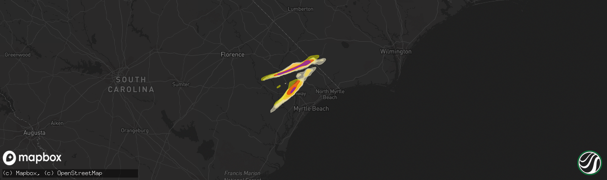
Hail Map in Conway, SC on April 7, 2022
The weather event in Conway, SC on April 7, 2022 includes Hail and Wind maps. 7 states and 128 cities were impacted and suffered possible damage. The total estimated number of properties impacted is 6,102.
Hail
Wind
6,102
Estimated number of impacted properties by a 1.00" hail or larger3,425
Estimated number of impacted properties by a 1.75" hail or larger0
Estimated number of impacted properties by a 2.50" hail or largerStorm reports in Conway, SC
Conway, SC
| Date | Description |
|---|---|
| 04/07/20223:14 PM CDT | Horry county em reported hail in the homewood area on u.s. 701. |
| 04/07/20223:12 PM CDT | Public reported quarter-sized hail in the keighley estates neighborhood near aynor... Sc. Report was sent to nws via media and social media. Time estimated via radar. |
| 04/07/20223:07 PM CDT | Public reported 2-inch hail near homewood... Sc along sc-319. Photos were provided via social media and relayed to nws via media. |
| 04/07/20223:06 PM CDT | Media reported ping-pong sized hail near conway... Sc. Pictures provided via social media. Time estimated via radar. |
| 04/07/20223:06 PM CDT | Media relayed report from individual located on el bethel rd. |
| 04/07/20223:03 PM CDT | Quarter size hail reported on pee dee rd... South of us highway 378. |
| 04/07/20223:03 PM CDT | Golf ball sized hail reported at conway-horry county airport. |
| 04/07/20223:03 PM CDT | Public reported quarter-sized hail along dunn shortcut rd. In conway... Sc. Time estimated via radar. |
| 04/07/20223:03 PM CDT | Reported near intersection of pee dee rd. And jordanville rd. |
| 04/07/20223:03 PM CDT | Sc highway patrol reports tree down on roadway near the intersection of pee dee highway and hendricks short-cut rd. |
All States Impacted by Hail Map on April 7, 2022
All Cities Impacted by Hail Map on April 7, 2022
- Belvidere, NC
- Tyner, NC
- Loris, SC
- Hobbsville, NC
- Colerain, NC
- Harrellsville, NC
- South Mills, NC
- Edenton, NC
- Cofield, NC
- Hertford, NC
- Ahoskie, NC
- Windsor, NC
- Elizabeth City, NC
- Aulander, NC
- Whitakers, NC
- Middlesex, NC
- Spring Hope, NC
- Scotland Neck, NC
- Elm City, NC
- Hobgood, NC
- Battleboro, NC
- Rocky Mount, NC
- Wilson, NC
- Bailey, NC
- Nashville, NC
- Tarboro, NC
- Galivants Ferry, SC
- Yankeetown, FL
- Inglis, FL
- Crystal River, FL
- Green Sea, SC
- Tabor City, NC
- Nichols, SC
- Kenly, NC
- Sims, NC
- Conway, SC
- Aynor, SC
- Hemingway, SC
- Wendell, NC
- Zebulon, NC
- Clayton, NC
- Selma, NC
- Linden, NC
- Fayetteville, NC
- Dunn, NC
- Erwin, NC
- Cuttyhunk, MA
- Fremont, NC
- Clarendon, NC
- Halifax, NC
- Hollister, NC
- Enfield, NC
- Louisburg, NC
- Castalia, NC
- Stantonsburg, NC
- Coats, NC
- Wake Forest, NC
- Rolesville, NC
- Greenville, NC
- Emporia, VA
- Black Creek, NC
- Dania, FL
- Fort Lauderdale, FL
- Murfreesboro, NC
- Marion, SC
- Yale, VA
- Waverly, VA
- Stony Creek, VA
- Raleigh, NC
- Rio Grande City, TX
- Knotts Island, NC
- Corolla, NC
- Virginia Beach, VA
- Walstonburg, NC
- Snow Hill, NC
- Gresham, SC
- Elkton, FL
- Saint Augustine, FL
- Newport News, VA
- Smithfield, NC
- Lucama, NC
- Georgetown, SC
- Pikeville, NC
- Goldsboro, NC
- Fountain, NC
- Merry Hill, NC
- Benson, NC
- Mount Olive, NC
- Sunbury, NC
- Windsor, VA
- Suffolk, VA
- Hawthorne, FL
- Micanopy, FL
- Pinetops, NC
- Gatesville, NC
- Camden, NC
- Lewiston Woodville, NC
- Oak City, NC
- Kelford, NC
- Faison, NC
- Jackson, NC
- Rich Square, NC
- Conway, NC
- Nakina, NC
- Whiteville, NC
- Chesapeake, VA
- Portsmouth, VA
- Youngsville, NC
- Jarratt, VA
- Zuni, VA
- Carrsville, VA
- Franklin, VA
- Crystal Beach, FL
- Palm Harbor, FL
- Andrews, SC
- Gates, NC
- Corapeake, NC
- Eure, NC
- Jacksonville, FL
- Exmore, VA
- Saint Marys, GA
- Kingsland, GA
- Patrick Afb, FL
- Fort Pierce, FL
- Woodland, NC
- Macclesfield, NC
- Smithfield, VA
- Hampton, VA


