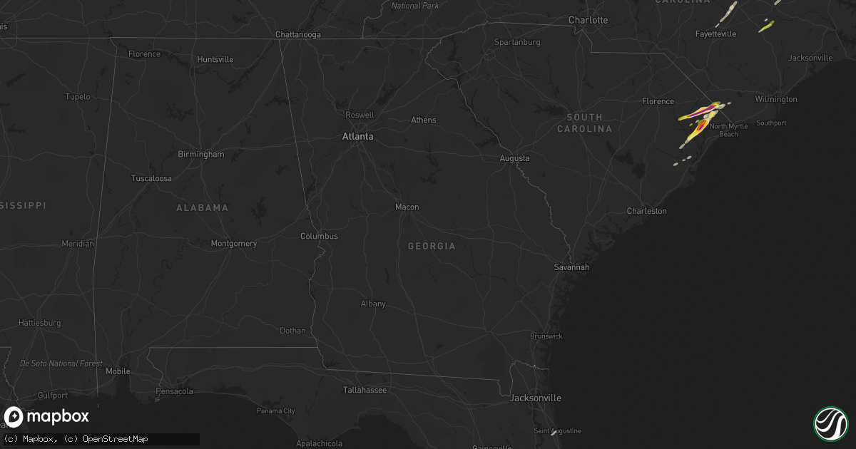
Hail Map in Georgia on April 7, 2022
Get this storm
April 7 map
$229
one time, instant access
Download today. No call, no setup
Keep the $229
Bought the map and want the full workflow? Apply the entire $229 to a subscription within 7 days. None of it is wasted.
Every map, not just this one
This buys you this map. Subscription and you get every map we run, in the markets you choose from a few cities to whole states to nationwide. Plus real-time alerts the moment a storm fires.
Contact data
Name, contact info, occupancy, even credit band for addresses in the footprint. You go from where it hit to who to call.
Become the source they trust
Unlimited branding weather history reports on demand. You already have the documented answer ready for the property owner, and you are the one who showed up with it.
Property data and RoofTrace estimates
Pull up any address you have got, its value and the exact code rules for that jurisdiction, straight from One Click Code. Then RoofTrace estimates the squares, pitch, and roof value, priced the way you price.
Storm reports in Georgia
Georgia
| Date | Description |
|---|---|
| 04/07/20221:45 PM CDT | Estimated quarter size hail report. |
| 04/06/202210:14 PM CDT | At 314 AM EDT, a severe thunderstorm was located over Dock Junction, moving east at 30 mph. HAZARD...60 mph wind gusts and quarter size hail. SOURCE...Radar indicated. IMPACT...Hail damage to vehicles is expected. Expect wind damage to roofs, siding, and trees. Locations impacted include... Brunswick, St. Simons Island, Dock Junction, Country Club Estates and Sea Island. |
| 04/06/202210:03 PM CDT | At 303 AM EDT, a severe thunderstorm was located 5 miles north of Hartwell, or near Reed Creek, moving northeast at 50 mph. HAZARD...60 mph wind gusts and quarter size hail. SOURCE...Radar indicated. IMPACT...Minor hail damage to vehicles is expected. Expect wind damage to trees and power lines. Locations impacted include... Anderson, Hartwell, Homeland Park, Belton, Northlake, Reed Creek, Starr, Anderson Airport, Lake Hartwell and Sandy Springs. |
| 04/06/20229:49 PM CDT | At 248 AM EDT, severe thunderstorms were located along a line extending from Waverly to 6 miles east of Kings Ferry to St. George, moving east at 45 mph. HAZARD...70 mph wind gusts. SOURCE...Radar indicated. IMPACT...Expect considerable tree damage. Damage is likely to mobile homes, roofs, and outbuildings. Locations impacted include... St. Marys, Kingsland, Fernandina Beach, Woodbine, Callahan, Jacksonville International Arpt, Kings Bay Base, Yulee, Kings Ferry and St. George. |
| 04/06/20229:23 PM CDT | At 223 AM EDT, severe thunderstorms were located along a line extending from near Race Pond to 7 miles southwest of Folkston to 6 miles north of Taylor, moving east at 50 mph. HAZARD...70 mph wind gusts. SOURCE...Radar indicated. IMPACT...Expect considerable tree damage. Damage is likely to mobile homes, roofs, and outbuildings. Locations impacted include... Kingsland, Hilliard, Folkston, Woodbine, Homeland, Kings Ferry, Tarboro and Colesburg. |
| 04/06/20228:37 PM CDT | At 137 AM EDT, severe thunderstorms were located along a line extending from 7 miles northwest of Fargo to near Needmore to near Jasper, moving east at 35 mph. HAZARD...60 mph wind gusts. SOURCE...Radar indicated. IMPACT...Expect damage to roofs, siding, and trees. Locations impacted include... Fargo, Stephen Foster State Park and Needmore. |
All States Impacted by Hail Map on April 7, 2022
Cities Impacted by Hail Map on April 7, 2022
- Belvidere, NC
- Tyner, NC
- Loris, SC
- Hobbsville, NC
- Colerain, NC
- Harrellsville, NC
- South Mills, NC
- Edenton, NC
- Cofield, NC
- Hertford, NC
- Ahoskie, NC
- Windsor, NC
- Elizabeth City, NC
- Aulander, NC
- Whitakers, NC
- Middlesex, NC
- Spring Hope, NC
- Scotland Neck, NC
- Elm City, NC
- Hobgood, NC
- Battleboro, NC
- Rocky Mount, NC
- Wilson, NC
- Bailey, NC
- Nashville, NC
- Tarboro, NC
- Galivants Ferry, SC
- Yankeetown, FL
- Inglis, FL
- Crystal River, FL
- Green Sea, SC
- Tabor City, NC
- Nichols, SC
- Kenly, NC
- Sims, NC
- Conway, SC
- Aynor, SC
- Hemingway, SC
- Wendell, NC
- Zebulon, NC
- Clayton, NC
- Selma, NC
- Linden, NC
- Fayetteville, NC
- Dunn, NC
- Erwin, NC
- Cuttyhunk, MA
- Fremont, NC
- Clarendon, NC
- Halifax, NC
- Hollister, NC
- Enfield, NC
- Louisburg, NC
- Castalia, NC
- Stantonsburg, NC
- Coats, NC
- Wake Forest, NC
- Rolesville, NC
- Greenville, NC
- Emporia, VA
- Black Creek, NC
- Dania, FL
- Fort Lauderdale, FL
- Murfreesboro, NC
- Marion, SC
- Yale, VA
- Waverly, VA
- Stony Creek, VA
- Raleigh, NC
- Rio Grande City, TX
- Knotts Island, NC
- Corolla, NC
- Virginia Beach, VA
- Walstonburg, NC
- Snow Hill, NC
- Gresham, SC
- Elkton, FL
- Saint Augustine, FL
- Newport News, VA
- Smithfield, NC
- Lucama, NC
- Georgetown, SC
- Pikeville, NC
- Goldsboro, NC
- Fountain, NC
- Merry Hill, NC
- Benson, NC
- Mount Olive, NC
- Sunbury, NC
- Windsor, VA
- Suffolk, VA
- Hawthorne, FL
- Micanopy, FL
- Pinetops, NC
- Gatesville, NC
- Camden, NC
- Lewiston Woodville, NC
- Oak City, NC
- Kelford, NC
- Faison, NC
- Jackson, NC
- Rich Square, NC
- Conway, NC
- Nakina, NC
- Whiteville, NC
- Chesapeake, VA
- Portsmouth, VA
- Youngsville, NC
- Jarratt, VA
- Zuni, VA
- Carrsville, VA
- Franklin, VA
- Crystal Beach, FL
- Palm Harbor, FL
- Andrews, SC
- Gates, NC
- Corapeake, NC
- Eure, NC
- Jacksonville, FL
- Exmore, VA
- Saint Marys, GA
- Kingsland, GA
- Patrick Afb, FL
- Fort Pierce, FL
- Woodland, NC
- Macclesfield, NC
- Smithfield, VA
- Hampton, VA


