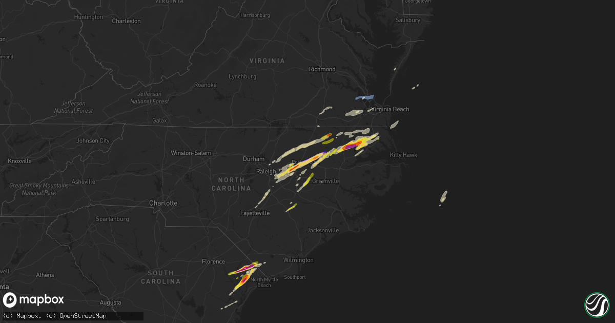
Hail Map on April 7, 2022
Get this storm
April 7 map
$229
one time, instant access
Download today. No call, no setup
Keep the $229
Bought the map and want the full workflow? Apply the entire $229 to a subscription within 7 days. None of it is wasted.
Every map, not just this one
This buys you this map. Subscription and you get every map we run, in the markets you choose from a few cities to whole states to nationwide. Plus real-time alerts the moment a storm fires.
Contact data
Name, contact info, occupancy, even credit band for addresses in the footprint. You go from where it hit to who to call.
Become the source they trust
Unlimited branding weather history reports on demand. You already have the documented answer ready for the property owner, and you are the one who showed up with it.
Property data and RoofTrace estimates
Pull up any address you have got, its value and the exact code rules for that jurisdiction, straight from One Click Code. Then RoofTrace estimates the squares, pitch, and roof value, priced the way you price.
States Impacted by Hail Map on April 7, 2022
Storm reports
Virginia
| Date | Description |
|---|---|
| 04/07/20225:44 PM CDT | Mesonet station xodu lafayette river. |
| 04/07/20225:28 PM CDT | Trees down near hampton coliseum. |
| 04/07/20224:45 PM CDT | Tree down. |
| 04/07/20222:06 AM CDT | At 705 PM EDT, severe thunderstorms were located along a line extending from near Fentress to Moyock to Burgess, moving east at 50 mph. HAZARD...Ping pong ball size hail and 60 mph wind gusts. SOURCE...Radar indicated. IMPACT...People and animals outdoors will be injured. Expect hail damage to roofs, siding, windows, and vehicles. Expect wind damage to trees and powerlines. Severe thunderstorms will be near... Princess Anne, Moyock, Back Bay and Fentress around 710 PM EDT. Currituck around 715 PM EDT. Weeksville and Knotts Island around 720 PM EDT. Old Trap and Shiloh around 730 PM EDT. Grandy around 745 PM EDT. Sanderling around 750 PM EDT.Other locations impacted by these severe thunderstorms include PoplarBranch, Spot, Saint Johns, Pungo, Jacocks, Light Nixon Fork, SpencesCorner, Goose Creek, Harvey Point and Taylors Beach. |
| 04/07/20221:12 AM CDT | At 612 PM EDT, severe thunderstorms were located along a line extending from near Holland to 7 miles north of Windsor, moving east at 40 mph. HAZARD...Ping pong ball size hail and 60 mph wind gusts. SOURCE...Radar indicated. IMPACT...People and animals outdoors will be injured. Expect hail damage to roofs, siding, windows, and vehicles. Expect wind damage to trees and powerlines. Severe thunderstorms will be near... Holland and Whaleyville around 615 PM EDT. Colerain around 625 PM EDT. Valhalla and Rockyhock around 630 PM EDT. Tyner around 635 PM EDT. Chesapeake around 640 PM EDT. Belvidere around 645 PM EDT. Hertford and Winfall around 650 PM EDT. Chapanoke around 655 PM EDT.Other locations impacted by these severe thunderstorms include GoosePond, Whites Crossroads, Tunis, Pierceville, Newsome Store, Savage,Arrowhead Beach, Chowan Beach, Topsy and Parkville. |
| 04/07/20221:09 AM CDT | At 608 PM EDT, a severe thunderstorm was located over Windsor, moving east at 35 mph. HAZARD...60 mph wind gusts and quarter size hail. SOURCE...Radar indicated. IMPACT...Minor damage to vehicles is possible. Expect wind damage to trees and powerlines. This severe thunderstorm will be near... Kings Fork around 615 PM EDT. Downtown Suffolk around 620 PM EDT. Suffolk, Driver and Crittenden around 630 PM EDT. Chesapeake, Western Branch and Bowers Hill around 635 PM EDT. Churchland and Deep Creek around 640 PM EDT. Downtown Portsmouth, Old Dominion University, Portsmouth, Ghent and Cradock around 645 PM EDT. Norfolk State University, Downtown Norfolk, Norview and Norfolk NAS around 650 PM EDT. Virginia Wesleyan University, Regent University, Ocean View and Norfolk International around 655 PM EDT.Other locations impacted by this severe thunderstorm include SouthNorfolk, Portlock, Longview, Mount Pleasant, Lummis, Suffolk Airport,Huntersville, Wills Corner, Herberts Corner and Magnolia. |
| 04/07/202212:50 AM CDT | At 550 PM EDT, a severe thunderstorm was located near Ivor, or 8 miles east of Wakefield, moving east at 50 mph. HAZARD...60 mph wind gusts and penny size hail. SOURCE...Radar indicated. IMPACT...Expect damage to trees and powerlines. This severe thunderstorm will be near... Isle Of Wight around 555 PM EDT. Smithfield around 600 PM EDT. Rescue and Fort Eustis around 610 PM EDT. Christopher Newport University, Patrick Henry Field, Beaconsdale and Denbigh around 615 PM EDT. Hampton, Northampton and Tabb around 620 PM EDT. Langley AFB, Hampton University, Buckroe Beach and Fort Monroe around 625 PM EDT. Grand View around 630 PM EDT.Other locations impacted by this severe thunderstorm includeRushmere, Pons, Carrollton, Chippokes State Park, Longview, BennsChurch, Oriana, Bethel Church, Ellis Fork and Hilton Village. |
| 04/07/202212:29 AM CDT | At 529 PM EDT, a severe thunderstorm was located 7 miles southwest of Conway, or 7 miles north of Rich Square, moving northeast at 40 mph. HAZARD...Golf ball size hail and 60 mph wind gusts. SOURCE...Radar indicated. IMPACT...People and animals outdoors will be injured. Expect hail damage to roofs, siding, windows, and vehicles. Expect wind damage to trees and powerlines. This severe thunderstorm will be near... Woodland around 535 PM EDT. Conway around 540 PM EDT. Murfreesboro and Chowan University around 550 PM EDT. Como around 600 PM EDT. Roduco around 610 PM EDT. Holland and Gates around 615 PM EDT.Other locations impacted by this severe thunderstorm includeMilwaukee, Tunis, Menola, Chowan Beach, Topsy, Mapleton, Buckland,Jackson, Dort and Bryantown. |
| 04/07/202212:12 AM CDT | At 511 PM EDT, a severe thunderstorm was located 7 miles east of Jarratt, or 13 miles northeast of Emporia, moving east at 40 mph. HAZARD...60 mph wind gusts and quarter size hail. SOURCE...Radar indicated. IMPACT...Minor damage to vehicles is possible. Expect wind damage to trees and powerlines. This severe thunderstorm will be near... Sussex around 520 PM EDT. Homeville around 530 PM EDT. Wakefield around 545 PM EDT. Ivor, Dendron and Zuni around 550 PM EDT.Other locations impacted by this severe thunderstorm includeVicksville, Booth Fork, Gray, Berlin, Booker, Yale, Lumberton, EllisFork, Manry and Huske. |
| 04/06/202211:52 PM CDT | At 451 PM EDT, a severe thunderstorm was located 8 miles southwest of Halifax, moving east at 55 mph. HAZARD...Golf ball size hail and 60 mph wind gusts. SOURCE...Radar indicated. IMPACT...People and animals outdoors will be injured. Expect hail damage to roofs, siding, windows, and vehicles. Expect wind damage to trees and powerlines. This severe thunderstorm will be near... Woodland around 520 PM EDT. Conway around 525 PM EDT.Other locations impacted by this severe thunderstorm includeEagletown, Mud Castle, Milwaukee, Pendleton, Potecasi, Lasker,Jackson, Bryantown, Boones Crossroads and Pleasant Grove. |
Florida
| Date | Description |
|---|---|
| 04/07/20223:50 PM CDT | Corrects previous tstm wnd dmg report from 1 s arlington. Large tree down on road. |
| 04/07/20223:40 PM CDT | Large tree down on road. |
| 04/07/20223:35 PM CDT | Corrects previous tstm wnd gst report from 4 ssw fort caroline. Asos station kcrg jacksonvil craig. |
| 04/07/20223:33 PM CDT | Asos station kcrg jacksonvil craig. |
| 04/07/20223:08 PM CDT | Awos station knrb mayport naval station. |
| 04/07/20223:00 PM CDT | Large tree down along fort caroline road near the intersection of harbour cove dr s. Radar estimated time. |
| 04/07/202212:47 PM CDT | Kfpr asos measures wind gust of 71kt/82mph |
| 04/07/202211:38 AM CDT | Broadcast media relays photos of a metal roof ripped off a portion of a home on gladwin ave in fern park. Time estimated from radar. |
| 04/07/202211:35 AM CDT | Pictures shared via social media of large trees and limbs down near gatlin and orange ave. Time estimated from radar. |
| 04/07/202211:21 AM CDT | Trained spotter reported large branches down on lauren beth ave and nicole ave in ocoee. Estimated winds up to 60 mph. Time estimated by radar. |
| 04/07/20227:13 AM CDT | At 1212 PM EDT, severe thunderstorms were located along a line extending from near Ferndale to near Lake Apopka to near Oakland to near Four Corners to 9 miles northwest of Combee Settlement, moving east at 45 mph. HAZARD...60 mph wind gusts and penny size hail. SOURCE...Radar indicated. IMPACT...Expect damage to roofs, siding, and trees. Locations impacted include... Orlando, Kissimmee, Sanford, Apopka and Altamonte Springs. |
| 04/07/20226:57 AM CDT | At 1152 AM EDT, severe thunderstorms were located along a line extending from near Mascotte to Groveland to Hillsborough River State Park, moving east at 45 mph. HAZARD...60 mph wind gusts and penny size hail. SOURCE...Radar indicated. IMPACT...Expect damage to roofs, siding, and trees. Locations impacted include... Apopka, Ocoee, Winter Garden, Groveland and Mascotte. |
| 04/07/20225:15 AM CDT | At 1014 AM EDT, a severe thunderstorm was located near Andalusia, moving east at 30 mph. HAZARD...60 mph wind gusts and penny size hail. SOURCE...Radar indicated. IMPACT...Expect damage to roofs, siding, and trees. Locations impacted include... Palm Coast, Flagler Beach, Bunnell, Beverly Beach and Espanola. |
| 04/07/20224:22 AM CDT | At 922 AM EDT, a severe thunderstorm was located near Lake Delancy, or near Salt Springs, moving east at 55 mph. HAZARD...60 mph wind gusts and nickel size hail. SOURCE...Radar indicated. IMPACT...Expect damage to roofs, siding, and trees. Locations impacted include... Palatka, Crescent City, Pomona Park, Salt Springs, East Palatka, Andalusia, Lake Delancy, Fruitland, San Mateo and Satsuma. |
| 04/07/20224:00 AM CDT | At 900 AM EDT, a severe thunderstorm was located 18 miles northwest of Crystal River Airport, or 22 miles northwest of Homosassa Springs, moving east at 35 mph. HAZARD...60 mph wind gusts and quarter size hail. SOURCE...Radar indicated. IMPACT...Hail damage to vehicles is expected. Expect wind damage to roofs, siding, and trees. Locations impacted include... Inglis, Lebanon, Citronelle, Crystal Manor and Citrus Springs. |
| 04/07/20223:47 AM CDT | At 847 AM EDT, a severe thunderstorm was located over Cross Creek, or 8 miles northwest of Citra, moving east at 45 mph. HAZARD...60 mph wind gusts. SOURCE...Radar indicated. IMPACT...Expect damage to roofs, siding, and trees. Locations impacted include... Citra, Hawthorne, Cross Creek, Orange Springs, Micanopy, McIntosh, Johnson, Lochloosa and Grove Park. |
| 04/07/20222:04 AM CDT | At 704 AM EDT, a severe thunderstorm was located near Picolata, or 11 miles southeast of Green Cove Springs, moving east at 25 mph. HAZARD...60 mph wind gusts. SOURCE...Radar indicated. IMPACT...Expect damage to roofs, siding, and trees. Locations impacted include... Saint Augustine, World Golf Village, Saint Augustine Beach, South Ponte Vedra, Vilano Beach, Saint Augustine South, Picolata, Saint Augustine Shores, Anastasia and Bakersville. |
| 04/06/202211:45 PM CDT | At 445 PM EDT, a severe thunderstorm was located near Baymeadows, or near Arlington, moving east at 35 mph. HAZARD...60 mph wind gusts and quarter size hail. SOURCE...Radar indicated. IMPACT...Hail damage to vehicles is expected. Expect wind damage to roofs, siding, and trees. Locations impacted include... Unf, Neptune Beach, Craig Field, San Pablo and Baymeadows. |
| 04/06/202211:35 PM CDT | At 435 PM EDT, a severe thunderstorm was located over Craig Field, or near Unf, moving east at 35 mph. HAZARD...60 mph wind gusts and quarter size hail. SOURCE...Radar indicated. IMPACT...Hail damage to vehicles is expected. Expect wind damage to roofs, siding, and trees. Locations impacted include... Neptune Beach, Fort Caroline and Craig Field. |
| 04/06/202211:26 PM CDT | At 426 AM EDT, a severe thunderstorm was located near Little Talbot Island, or 10 miles south of Fernandina Beach, moving east at 20 mph. HAZARD...60 mph wind gusts and quarter size hail. SOURCE...Radar indicated. IMPACT...Hail damage to vehicles is expected. Expect wind damage to roofs, siding, and trees. Locations impacted include... Neptune Beach, Oceanway, Craig Field, Little Talbot Island and Fort Caroline. |
| 04/06/20229:13 PM CDT | At 212 PM EDT, a severe thunderstorm was located near Fort Pierce North, or near Fort Pierce, moving northeast at 30 mph. HAZARD...60 mph wind gusts and penny size hail. SOURCE...Radar indicated. IMPACT...Expect damage to roofs, siding, and trees. Locations impacted include... Fort Pierce, Indrio, Fort Pierce Inlet, Queens Cove and Fort Pierce North. |
| 04/06/20229:07 PM CDT | At 207 AM EDT, severe thunderstorms were located along a line extending from 6 miles northeast of Stephen Foster State Park to 18 miles north of Taylor to 10 miles south of Fargo, moving east at 50 mph. HAZARD...60 mph wind gusts. SOURCE...Radar indicated. IMPACT...Expect damage to roofs, siding, and trees. Locations impacted include... Folkston, Stephen Foster State Park and Homeland. |
| 04/06/20229:02 PM CDT | At 202 PM EDT, a severe thunderstorm was located over Federal Point, or near Hastings, moving northeast at 45 mph. HAZARD...60 mph wind gusts and quarter size hail. SOURCE...Radar indicated. IMPACT...Hail damage to vehicles is expected. Expect wind damage to roofs, siding, and trees. Locations impacted include... Saint Augustine, Hastings, Saint Augustine Beach, Vilano Beach, Federal Point, Saint Augustine Shores, Butler Beach, Saint Augustine South, Crescent Beach and Spuds. |
| 04/06/20229:01 PM CDT | At 201 PM EDT, a severe thunderstorm was located over Twin Lakes, or near Lauderdale-By-The-Sea, moving east at 35 mph. HAZARD...60 mph wind gusts and quarter size hail. SOURCE...Radar indicated. IMPACT...Hail damage to vehicles is expected. Expect wind damage to roofs, siding, and trees. Locations impacted include... Fort Lauderdale, Coral Springs, Pompano Beach, Plantation and Sunrise. |
| 04/06/20228:48 PM CDT | At 148 PM EDT, a severe thunderstorm was located over Lakewood Park, or over Indrio, moving northeast at 30 mph. HAZARD...60 mph wind gusts and penny size hail. SOURCE...Radar indicated. IMPACT...Expect damage to roofs, siding, and trees. Locations impacted include... Fort Pierce, Indrio, Queens Cove, Vero Beach Highland and Fort Pierce North. |
| 04/06/20228:43 PM CDT | At 143 PM EDT, a severe thunderstorm was located over Sunrise, moving northeast at 25 mph. HAZARD...60 mph wind gusts and quarter size hail. SOURCE...Radar indicated. IMPACT...Hail damage to vehicles is expected. Expect wind damage to roofs, siding, and trees. Locations impacted include... Fort Lauderdale, Coral Springs, Pompano Beach, Davie and Plantation. |
| 04/06/20228:00 PM CDT | At 100 AM EDT, a severe thunderstorm was located over Lake Park, moving east at 35 mph. HAZARD...60 mph wind gusts. SOURCE...Radar indicated. IMPACT...Expect damage to roofs, siding, and trees. Locations impacted include... Lake Park, Dasher, I-75 At Exit 5 and Twin Lakes. |
South Carolina
| Date | Description |
|---|---|
| 04/07/20223:34 PM CDT | Sc highway patrol reports power lines down near the intersection of green sea rd and west dogwood rd. |
| 04/07/20223:26 PM CDT | Public reported quarter-sized hail along sc-9 west of loris... Sc. Video shared via social media and relayed to nws via media. |
| 04/07/20223:16 PM CDT | Public reported golf ball sized hail near loris... Sc. Time estimated via radar and pictuers were proivded via social media. |
| 04/07/20223:14 PM CDT | Horry county em reported hail in the homewood area on u.s. 701. |
| 04/07/20223:12 PM CDT | Public reported quarter-sized hail in the keighley estates neighborhood near aynor... Sc. Report was sent to nws via media and social media. Time estimated via radar. |
| 04/07/20223:07 PM CDT | Public reported 2-inch hail near homewood... Sc along sc-319. Photos were provided via social media and relayed to nws via media. |
| 04/07/20223:06 PM CDT | Media reported ping-pong sized hail near conway... Sc. Pictures provided via social media. Time estimated via radar. |
| 04/07/20223:06 PM CDT | Public reported baseball-sized hail and damage to a vehicle near galivants ferry... Sc. Report was sent to nws via media and social media |
| 04/07/20223:06 PM CDT | Media relayed report from individual located on el bethel rd. |
| 04/07/20223:03 PM CDT | Reported near intersection of pee dee rd. And jordanville rd. |
| 04/07/20223:03 PM CDT | Quarter size hail reported on pee dee rd... South of us highway 378. |
| 04/07/20223:03 PM CDT | Golf ball sized hail reported at conway-horry county airport. |
| 04/07/20223:03 PM CDT | Public reported quarter-sized hail along dunn shortcut rd. In conway... Sc. Time estimated via radar. |
| 04/07/20223:03 PM CDT | Sc highway patrol reports tree down on roadway near the intersection of pee dee highway and hendricks short-cut rd. |
| 04/06/202211:22 PM CDT | At 422 PM EDT, a severe thunderstorm was located over Tabor City, or 18 miles southwest of Whiteville, moving east at 45 mph. HAZARD...Two inch hail and 60 mph wind gusts. SOURCE...Radar indicated. IMPACT...People and animals outdoors will be injured. Expect hail damage to roofs, siding, windows, and vehicles. Expect wind damage to trees and power lines. Locations impacted include... Whiteville, Tabor City, Bethel, Lake Waccamaw, Hallsboro, Honey Island, Nakina, Redbug, Old Dock, Mollie, Sidney, Clarendon, Williams, Crusoe Island, Brunswick and Bolton. |
| 04/06/202210:46 PM CDT | At 345 PM EDT, a severe thunderstorm was located near Outland, or 16 miles southwest of Conway, moving northeast at 45 mph. HAZARD...60 mph wind gusts and quarter size hail. SOURCE...Radar indicated. IMPACT...Minor hail damage to vehicles is possible. Expect wind damage to trees and power lines. Locations impacted include... Myrtle Beach, Conway, North Myrtle Beach, Surfside Beach, Myrtle Beach Airport, Socastee, Red Hill, Springmaid Pier, Garden City, North Myrtle Beach Airport, Murrells Inlet, Horry, Loris, Hickory Grove, Homewood, Horry Georgetown Technical College Conway Campus, Adrian, Pee Dee Crossroads, Oatland and Nixonville. |
| 04/06/202210:29 PM CDT | At 329 AM EDT, a severe thunderstorm was located 6 miles northeast of Anderson, or 4 miles northwest of Belton, moving northeast at 55 mph. HAZARD...60 mph wind gusts and quarter size hail. SOURCE...Radar indicated. IMPACT...Minor hail damage to vehicles is expected. Expect wind damage to trees and power lines. Locations impacted include... Anderson, Mauldin, Simpsonville, Fountain Inn, Homeland Park, Piedmont, Belton, Williamston, Northlake and West Pelzer. |
| 04/06/202210:25 PM CDT | At 325 PM EDT, a severe thunderstorm was located near Lambert, or 13 miles west of Georgetown, moving northeast at 40 mph. HAZARD...60 mph wind gusts and quarter size hail. SOURCE...Radar indicated. IMPACT...Minor hail damage to vehicles is possible. Expect wind damage to trees and power lines. Locations impacted include... Georgetown, DeBordieu Colony, Pawleys Island, Andrews, Lambert, Sampit, Plantersville, Graves, Oatland, Litchfield Beach and Georgetown Memorial Hospital. |
| 04/06/202210:20 PM CDT | At 320 AM EDT, a severe thunderstorm was located near Walhalla, moving northeast at 45 mph. HAZARD...60 mph wind gusts and quarter size hail. SOURCE...Radar indicated. IMPACT...Minor hail damage to vehicles is expected. Expect wind damage to trees and power lines. Locations impacted include... Seneca, Walhalla, Central, Liberty, Westminster, Norris, Six Mile, Salem, Lake Keowee and Jocassee Gorges. |
| 04/06/20229:38 PM CDT | At 238 PM EDT, a severe thunderstorm was located near Magnolia Gardens, moving northeast at 55 mph. HAZARD...60 mph wind gusts and quarter size hail. SOURCE...Radar indicated. IMPACT...Minor hail damage to vehicles is possible. Expect wind damage to trees and powerlines. Locations impacted include: North Charleston, Mount Pleasant, Summerville, Goose Creek, Hanahan, McClellanville, Fort Sumter, Downtown Charleston, West Ashley, Daniel Island, Naval Weapons Station Charleston, Johns Island, Ladson, I-26/I-526 Interchange and Hollywood.This warning includes the following interstates: I-26 between mile markers 198 and 221. I-526 between mile markers 11 and 31. |
Georgia
| Date | Description |
|---|---|
| 04/07/20221:45 PM CDT | Estimated quarter size hail report. |
| 04/06/202210:14 PM CDT | At 314 AM EDT, a severe thunderstorm was located over Dock Junction, moving east at 30 mph. HAZARD...60 mph wind gusts and quarter size hail. SOURCE...Radar indicated. IMPACT...Hail damage to vehicles is expected. Expect wind damage to roofs, siding, and trees. Locations impacted include... Brunswick, St. Simons Island, Dock Junction, Country Club Estates and Sea Island. |
| 04/06/202210:03 PM CDT | At 303 AM EDT, a severe thunderstorm was located 5 miles north of Hartwell, or near Reed Creek, moving northeast at 50 mph. HAZARD...60 mph wind gusts and quarter size hail. SOURCE...Radar indicated. IMPACT...Minor hail damage to vehicles is expected. Expect wind damage to trees and power lines. Locations impacted include... Anderson, Hartwell, Homeland Park, Belton, Northlake, Reed Creek, Starr, Anderson Airport, Lake Hartwell and Sandy Springs. |
| 04/06/20229:49 PM CDT | At 248 AM EDT, severe thunderstorms were located along a line extending from Waverly to 6 miles east of Kings Ferry to St. George, moving east at 45 mph. HAZARD...70 mph wind gusts. SOURCE...Radar indicated. IMPACT...Expect considerable tree damage. Damage is likely to mobile homes, roofs, and outbuildings. Locations impacted include... St. Marys, Kingsland, Fernandina Beach, Woodbine, Callahan, Jacksonville International Arpt, Kings Bay Base, Yulee, Kings Ferry and St. George. |
| 04/06/20229:23 PM CDT | At 223 AM EDT, severe thunderstorms were located along a line extending from near Race Pond to 7 miles southwest of Folkston to 6 miles north of Taylor, moving east at 50 mph. HAZARD...70 mph wind gusts. SOURCE...Radar indicated. IMPACT...Expect considerable tree damage. Damage is likely to mobile homes, roofs, and outbuildings. Locations impacted include... Kingsland, Hilliard, Folkston, Woodbine, Homeland, Kings Ferry, Tarboro and Colesburg. |
| 04/06/20228:37 PM CDT | At 137 AM EDT, severe thunderstorms were located along a line extending from 7 miles northwest of Fargo to near Needmore to near Jasper, moving east at 35 mph. HAZARD...60 mph wind gusts. SOURCE...Radar indicated. IMPACT...Expect damage to roofs, siding, and trees. Locations impacted include... Fargo, Stephen Foster State Park and Needmore. |
North Carolina
| Date | Description |
|---|---|
| 04/07/20226:00 PM CDT | Time estimated from radar. |
| 04/07/20225:45 PM CDT | Tree down. Time estimated from radar. |
| 04/07/20225:38 PM CDT | Trees and power lines down near corapeake. |
| 04/07/20225:31 PM CDT | Public reported up to a 10 minute period of hail... Putting about 50 holes in the vinyl siding. Largest hail size was estimated to be the size of a quarter. Location wa |
| 04/07/20225:25 PM CDT | A local report indicates 1.75 inch wind near 2 SSW NEWSOME STORE |
| 04/07/20225:22 PM CDT | Damage to maintenance buildings at gatesville elementary. |
| 04/07/20225:22 PM CDT | Report from mping: quarter |
| 04/07/20225:20 PM CDT | *** 1 inj *** corrects previous tstm wnd dmg report from 3 sw powellsville. Mobile home blown over... Multiple trees down. Time estimated from radar. |
| 04/07/20225:20 PM CDT | Mobile home blown over... Multiple trees down. Time estimated from radar. |
| 04/07/20225:18 PM CDT | Hail lasted for 5 minutes. |
| 04/07/20225:01 PM CDT | Quarter size hail reported on hoyt rd near middlesex... Nc. |
| 04/07/20224:39 PM CDT | Tree down in roadway. |
| 04/07/20224:37 PM CDT | Quarter size hail reported on elevation road near benson... Nc. |
| 04/07/20224:37 PM CDT | Tree down on roadway. |
| 04/07/20224:35 PM CDT | A local report indicates 1.00 inch wind near RICH SQUARE |
| 04/07/20224:30 PM CDT | 2 trees down blocking roadway on nc hwy 97. |
| 04/07/20224:30 PM CDT | Quarter size hail reported near i-95 just south of nashville... Nc. |
| 04/07/20224:24 PM CDT | Trees down blocking roadway along nc97e. |
| 04/07/20224:21 PM CDT | Tree down on draughn rd. |
| 04/07/20224:20 PM CDT | Golf ball size hail reported between 530pm and 540pm. |
| 04/07/20224:20 PM CDT | Report via facebook. |
| 04/07/20224:14 PM CDT | Tree down on dunbar woods rd and new hope church rd. |
| 04/07/20224:10 PM CDT | Tree down on house on wiggins lake road... No injuries. |
| 04/07/20223:56 PM CDT | Storm spotter reports ping pong size hail just north of new hope... Nc. |
| 04/07/20223:48 PM CDT | Tree down near mary shearin rd. |
| 04/07/20223:45 PM CDT | Public report. |
| 04/07/20223:41 PM CDT | Tree down on hwy 158. |
| 04/07/20223:25 PM CDT | Thunderstorm produced 1.50inch hail |
| 04/07/20223:25 PM CDT | Thunderstorm produced ping pong ball size hail. |
| 04/07/20223:23 PM CDT | Pine tree down on chambee road southeast of zebulon. |
| 04/07/20222:14 AM CDT | At 713 PM EDT, a severe thunderstorm was located over Stokes, or 11 miles northeast of Greenville, moving northeast at 55 mph. HAZARD...60 mph wind gusts and nickel size hail. SOURCE...Radar indicated. IMPACT...Expect damage to roofs, siding, and trees. Locations impacted include... Greenville, Williamston, Stokes, Robersonville, Pactolus, Jamesville, Simpson, Smithwick, Everetts, Dardens and Beargrass. |
| 04/07/20221:28 AM CDT | At 627 PM EDT, severe thunderstorms were located along a line extending from 8 miles northwest of Bruce to near Kinston, moving northeast at 75 mph. HAZARD...60 mph wind gusts and nickel size hail. SOURCE...Radar indicated. IMPACT...Expect damage to roofs, siding, and trees. Locations impacted include... Greenville, Washington, Winterville, Williamston, Ayden, Farmville, Bethel, Grifton, Stokes, Bell Arthur, Robersonville, Pactolus, House, Black Jack, Bruce, Graingers, Maury, Ormondsville, Roundtree and Lizzie. |
| 04/07/20221:05 AM CDT | At 604 PM EDT, a severe thunderstorm was located near Bowdens, or 7 miles northeast of Clinton, moving northeast at 45 mph. HAZARD...60 mph wind gusts and nickel size hail. SOURCE...Radar indicated. IMPACT...Expect damage to roofs, siding, and trees. Locations impacted include... Kinston, Warsaw, La Grange, Mount Olive, Snow Hill, Bowdens, Beautancus, Dawson, Institute, Jason, Kinston Regional Jetport, Faison, Calypso, Sandy Bottom, Shine, Fort Run VFD and Bull Head VFD. |
| 04/07/202212:57 AM CDT | At 557 PM EDT, a severe thunderstorm was located near Smithfield, moving northeast at 50 mph. HAZARD...60 mph wind gusts and quarter size hail. SOURCE...Radar indicated. IMPACT...Hail damage to vehicles is expected. Expect wind damage to roofs, siding, and trees. Locations impacted include... Rocky Mount, Tarboro, Smithfield, Nashville, Wilson, Clayton, Scotland Neck, Elm City, Dortches and Bailey. |
| 04/07/202212:33 AM CDT | At 532 PM EDT, a severe thunderstorm was located near Scotland Neck, or 13 miles south of Rich Square, moving northeast at 60 mph. HAZARD...Golf ball size hail and 60 mph wind gusts. SOURCE...Radar indicated. IMPACT...People and animals outdoors will be injured. Expect hail damage to roofs, siding, windows, and vehicles. Expect wind damage to trees and powerlines. This severe thunderstorm will be near.<!-- <WEItem parmID="WBGT_SFC:AKQ_GRID__Fcst_00000000_0000" relativeCycleNumber="-1"/> --> <!-- <WEItem parmID="MaxWBGT_SFC:AKQ_GRID__Fcst_00000000_0000" relativeCycleNumber="-1"/> -->.. Roxobel around 540 PM EDT. Lewiston Woodville around 545 PM EDT. Aulander around 550 PM EDT. Ahoskie and Powellsville around 600 PM EDT. Winton and Cofield around 605 PM EDT. Harrellsville around 610 PM EDT.Other locations impacted by this severe thunderstorm include GoosePond, Eagletown, Whites Crossroads, Tunis, Kelford, Earleys, Menola,Newsome Store, Connaritsa and Republican. |
| 04/07/202212:16 AM CDT | At 515 PM EDT, a severe thunderstorm was located near Tarboro, moving east at 60 mph. HAZARD...Ping pong ball size hail and 60 mph wind gusts. SOURCE...Radar indicated. IMPACT...People and animals outdoors will be injured. Expect hail damage to roofs, siding, windows, and vehicles. Expect wind damage to roofs, siding, and trees. Locations impacted include... Gold Point, Hamilton, Oak City and Hassell. |
| 04/07/202212:16 AM CDT | At 515 PM EDT, a severe thunderstorm was located near Godwin, or 11 miles southeast of Lillington, moving northeast at 50 mph. HAZARD...60 mph wind gusts and quarter size hail. SOURCE...Radar indicated. IMPACT...Hail damage to vehicles is expected. Expect wind damage to roofs, siding, and trees. Locations impacted include... Smithfield, Lillington, Clayton, Dunn, Benson, Bailey, Godwin, Micro, Selma and Erwin. |
| 04/07/202212:09 AM CDT | At 508 PM EDT, severe thunderstorms were located along a line extending from near Halifax to near Rocky Mount, moving east at 60 mph. HAZARD...Golf ball size hail and 60 mph wind gusts. SOURCE...Radar indicated. IMPACT...People and animals outdoors will be injured. Expect hail damage to roofs, siding, windows, and vehicles. Expect wind damage to roofs, siding, and trees. Locations impacted include... Tarboro, Scotland Neck, Princeville, Hobgood, Conetoe, Speed, Leggett, Tillery and Kingsboro. |
| 04/07/202212:03 AM CDT | At 502 PM EDT, a severe thunderstorm was located near Lake Waccamaw, or 15 miles east of Whiteville, moving northeast at 45 mph. HAZARD...Quarter size hail. SOURCE...Radar indicated. IMPACT...Minor damage to vehicles is possible. Locations impacted include... Rowan, Lake Waccamaw, Northwest, Sandyfield, Point Caswell, Hallsboro, Long Creek, Cape Fear Community College North Campus, Redbug, Council, Currie, Castle Hayne, Wards Corner, The Borough, Phoenix, Riegelwood, Carvers, Old Dock, Wrightsboro and Montague. |
| 04/06/202211:37 PM CDT | At 437 PM EDT, a severe thunderstorm was located 7 miles southwest of Bailey, or 16 miles northeast of Smithfield, moving east at 45 mph. HAZARD...60 mph wind gusts and quarter size hail. SOURCE...Radar indicated. IMPACT...Hail damage to vehicles is expected. Expect wind damage to roofs, siding, and trees. Locations impacted include... Rocky Mount, Tarboro, Nashville, Wilson, Elm City, Bailey, Princeville, Sharpsburg, Pinetops and Spring Hope. |
| 04/06/202211:33 PM CDT | At 433 PM EDT, a severe thunderstorm was located near Myrtle Beach, moving northeast at 45 mph. HAZARD...Quarter size hail. SOURCE...Radar indicated. IMPACT...Minor damage to vehicles is possible. Locations impacted include... Myrtle Beach, North Myrtle Beach, Oak Island, Shallotte, Sunset Beach, Holden Beach, Ocean Isle Beach, North Myrtle Beach Airport, Little River, Iredell, Carolina Shores, Calabash, Civie Town, Grissettown, Seaside, Barefoot Landing Area Of North Myrtle Beach, Russtown, Brooksville, Varnamtown and Briarcliffe Acres. |
| 04/06/202211:27 PM CDT | At 426 PM EDT, a severe thunderstorm was located 8 miles east of Louisburg, moving northeast at 50 mph. HAZARD...60 mph wind gusts and quarter size hail. SOURCE...Radar indicated. IMPACT...Hail damage to vehicles is expected. Expect wind damage to roofs, siding, and trees. Locations impacted include... Rocky Mount, Roanoke Rapids, Nashville, Halifax, Scotland Neck, Dortches, Littleton, Red Oak, Enfield and Weldon. |
| 04/06/202211:24 PM CDT | At 424 PM EDT, a severe thunderstorm was located over Loris, or 17 miles northeast of Conway, moving northeast at 60 mph. HAZARD...Golf ball size hail. SOURCE...Emergency management. IMPACT...People and animals outdoors will be injured. Expect damage to roofs, siding, windows, and vehicles. Locations impacted include... Loris, Dulah, Goretown, Bughill, Bayboro, Allsbrook, Green Sea and Loris Community Hospital. |
| 04/06/202211:01 PM CDT | At 400 PM EDT, a severe thunderstorm was located near Garner, or 9 miles southeast of Raleigh, moving northeast at 40 mph. HAZARD...60 mph wind gusts and quarter size hail. SOURCE...Radar indicated. IMPACT...Hail damage to vehicles is expected. Expect wind damage to roofs, siding, and trees. Locations impacted include... Raleigh, Garner, Clayton, Zebulon, Bailey, Bunn, Knightdale, Wendell, Spring Hope and Middlesex. |
| 04/06/202210:50 PM CDT | At 350 PM EDT, a severe thunderstorm was located over Galivants Ferry, or 13 miles south of Mullins, moving east at 50 mph. HAZARD...60 mph wind gusts and quarter size hail. SOURCE...Radar indicated. IMPACT...Minor hail damage to vehicles is possible. Expect wind damage to trees and power lines. Locations impacted include... Whiteville, Tabor City, Loris, Bethel, Galivants Ferry, Nakina, Mollie, Bughill, Sidney, Clarendon, Williams, Pireway, Dulah, Goretown, Bayboro, Allsbrook, Green Sea, Brunswick, Aynor and Columbus Regional Healthcare System. |
| 04/06/202210:43 PM CDT | At 343 PM EDT, a severe thunderstorm was located near Cary, moving northeast at 50 mph. HAZARD...60 mph wind gusts and quarter size hail. SOURCE...Radar indicated. IMPACT...Hail damage to vehicles is expected. Expect wind damage to roofs, siding, and trees. Locations impacted include... Raleigh, Cary, Henderson, Creedmoor, Louisburg, Wake Forest, Franklinton, Kittrell, RDU International and Morrisville. |
| 04/06/202210:25 PM CDT | At 324 PM EDT, a severe thunderstorm was located 7 miles west of Lillington, moving northeast at 40 mph. HAZARD...60 mph wind gusts and quarter size hail. SOURCE...Radar indicated. IMPACT...Hail damage to vehicles is expected. Expect wind damage to roofs, siding, and trees. Locations impacted include... Smithfield, Lillington, Fuquay-Varina, Clayton, Angier, Coats, Four Oaks, Seminole, Raven Rock State Park and Coats Crossroads. |
Nebraska
| Date | Description |
|---|---|
| 04/07/20226:45 PM CDT | 64 mph winds... Report via social media. |
Cities Impacted by Hail Map on April 7, 2022
- Belvidere, NC
- Tyner, NC
- Loris, SC
- Hobbsville, NC
- Colerain, NC
- Harrellsville, NC
- South Mills, NC
- Edenton, NC
- Cofield, NC
- Hertford, NC
- Ahoskie, NC
- Windsor, NC
- Elizabeth City, NC
- Aulander, NC
- Whitakers, NC
- Middlesex, NC
- Spring Hope, NC
- Scotland Neck, NC
- Elm City, NC
- Hobgood, NC
- Battleboro, NC
- Rocky Mount, NC
- Wilson, NC
- Bailey, NC
- Nashville, NC
- Tarboro, NC
- Galivants Ferry, SC
- Yankeetown, FL
- Inglis, FL
- Crystal River, FL
- Green Sea, SC
- Tabor City, NC
- Nichols, SC
- Kenly, NC
- Sims, NC
- Conway, SC
- Aynor, SC
- Hemingway, SC
- Wendell, NC
- Zebulon, NC
- Clayton, NC
- Selma, NC
- Linden, NC
- Fayetteville, NC
- Dunn, NC
- Erwin, NC
- Cuttyhunk, MA
- Fremont, NC
- Clarendon, NC
- Halifax, NC
- Hollister, NC
- Enfield, NC
- Louisburg, NC
- Castalia, NC
- Stantonsburg, NC
- Coats, NC
- Wake Forest, NC
- Rolesville, NC
- Greenville, NC
- Emporia, VA
- Black Creek, NC
- Dania, FL
- Fort Lauderdale, FL
- Murfreesboro, NC
- Marion, SC
- Yale, VA
- Waverly, VA
- Stony Creek, VA
- Raleigh, NC
- Rio Grande City, TX
- Knotts Island, NC
- Corolla, NC
- Virginia Beach, VA
- Walstonburg, NC
- Snow Hill, NC
- Gresham, SC
- Elkton, FL
- Saint Augustine, FL
- Newport News, VA
- Smithfield, NC
- Lucama, NC
- Georgetown, SC
- Pikeville, NC
- Goldsboro, NC
- Fountain, NC
- Merry Hill, NC
- Benson, NC
- Mount Olive, NC
- Sunbury, NC
- Windsor, VA
- Suffolk, VA
- Hawthorne, FL
- Micanopy, FL
- Pinetops, NC
- Gatesville, NC
- Camden, NC
- Lewiston Woodville, NC
- Oak City, NC
- Kelford, NC
- Faison, NC
- Jackson, NC
- Rich Square, NC
- Conway, NC
- Nakina, NC
- Whiteville, NC
- Chesapeake, VA
- Portsmouth, VA
- Youngsville, NC
- Jarratt, VA
- Zuni, VA
- Carrsville, VA
- Franklin, VA
- Crystal Beach, FL
- Palm Harbor, FL
- Andrews, SC
- Gates, NC
- Corapeake, NC
- Eure, NC
- Jacksonville, FL
- Exmore, VA
- Saint Marys, GA
- Kingsland, GA
- Patrick Afb, FL
- Fort Pierce, FL
- Woodland, NC
- Macclesfield, NC
- Smithfield, VA
- Hampton, VA