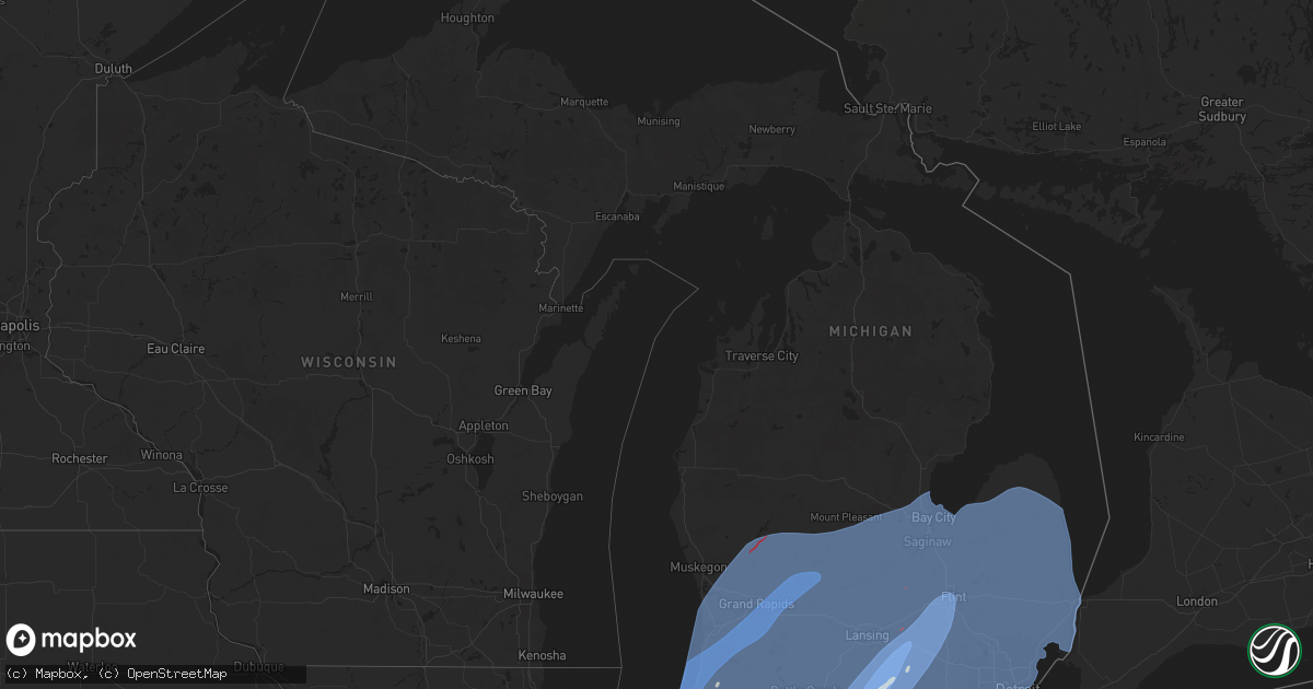
Hail Map in Michigan on March 30, 2025
Get this storm
March 30 map
$229
one time, instant access
Download today. No call, no setup
Keep the $229
Bought the map and want the full workflow? Apply the entire $229 to a subscription within 7 days. None of it is wasted.
Every map, not just this one
This buys you this map. Subscription and you get every map we run, in the markets you choose from a few cities to whole states to nationwide. Plus real-time alerts the moment a storm fires.
Contact data
Name, contact info, occupancy, even credit band for addresses in the footprint. You go from where it hit to who to call.
Become the source they trust
Unlimited branding weather history reports on demand. You already have the documented answer ready for the property owner, and you are the one who showed up with it.
Property data and RoofTrace estimates
Pull up any address you have got, its value and the exact code rules for that jurisdiction, straight from One Click Code. Then RoofTrace estimates the squares, pitch, and roof value, priced the way you price.
Storm reports in Michigan
Michigan
| Date | Description |
|---|---|
| 03/30/20256:52 PM CDT | Dispatch reports trees down |
| 03/30/20256:49 PM CDT | Tree fell on mobile home. |
| 03/30/20256:47 PM CDT | Power lines down and roof blown off. |
| 03/30/20256:38 PM CDT | Dispatch reports trees down near jewell and 27 mile road |
| 03/30/20256:33 PM CDT | Dispatch reports trees and wires down throughout area |
| 03/30/20256:30 PM CDT | Tree down on wires near livernois and wendelton roads |
| 03/30/20256:18 PM CDT | Dispatch reports multiple trees down on houses in the southern part of the county. |
| 03/30/20256:17 PM CDT | A local report indicates 63 MPH wind near Detroit Metro Intl Airp |
| 03/30/20256:12 PM CDT | Report of numerous 8 to 10 inch diameter tree limbs down across grand blanc... Downed power lines... And a few flooded roads. A few smaller trees were also uprooted. Es |
| 03/30/20256:12 PM CDT | Also reported quarter sized hail |
| 03/30/20256:11 PM CDT | Pictures of damaged fencing... Shredded netting... And snapped poles at powers catholic high school baseball fields |
| 03/30/20256:10 PM CDT | Measured on private weather station |
| 03/30/20256:09 PM CDT | A local report indicates 61 MPH wind near Flint Bishop Intl Airpo |
| 03/30/20256:07 PM CDT | Emergency management reports mobile homes damaged in the holiday estates mobile home park. |
| 03/30/20256:07 PM CDT | Spotter reported trees uprooted near the intersection of morrish adn lennon roads and on van vleet road. |
| 03/30/20256:07 PM CDT | A local report indicates 63 MPH wind near Willow Run Airport |
| 03/30/20256:07 PM CDT | Delayed report. Numerous large trees uprooted... All were blown down in the same direction. One tree fell on a home and caused significant damage. A nearby large shed o |
| 03/30/20256:05 PM CDT | Large pine snapped and partially uprooted |
| 03/30/20256:05 PM CDT | Video of large tree uprooted |
| 03/30/20255:59 PM CDT | Large pine uprooted and down on a garage |
| 03/30/20255:57 PM CDT | Trees down including one partially uprooted taking the sidewalk with it on broadway av. |
| 03/30/20255:57 PM CDT | Tree uprooted and street sign bent |
| 03/30/20255:54 PM CDT | Estimated wind gusts with pea to half inch sized hail |
| 03/30/20255:53 PM CDT | A local report indicates 75 MPH wind near 1 NE Howell |
| 03/30/20255:51 PM CDT | 2 foot diameter tree down near liberty and dornoch rds. |
| 03/30/20255:40 PM CDT | An ef1 tornado caused damage to multiple houses including a two story home that lost its roof. Several other homes had roof and siding damage. There was also damage to |
| 03/30/20255:37 PM CDT | Roof blown off an assisted living center. All 7 residents safe. |
| 03/30/20255:32 PM CDT | Asos station klan lansing. |
| 03/30/20255:30 PM CDT | Report from mping: quarter time estimated via radar. |
| 03/30/20255:30 PM CDT | Report from mping: quarter |
| 03/30/20255:28 PM CDT | Delayed report. Time estimated via radar. Barn with roof partially removed. |
| 03/30/20255:28 PM CDT | Delayed report. Time estimated via radar. Large tree down over dexter trail. |
| 03/30/20255:24 PM CDT | Delayed report. Time estimated via radar. Several photos of social media on downed trees. |
| 03/30/20255:22 PM CDT | Delayed report. Time estimated via radar. Several downed trees and large limbs in grand ledge area. |
| 03/30/20255:20 PM CDT | Ef0 began at olds road south of leslie... Mi. Caused tree damage along the path as well as minor damage to homes and resulted in the loss of several outbuildings. Total |
| 03/30/20255:20 PM CDT | Delayed report. Time estimated via radar. Wire down on grand ledge hwy. |
| 03/30/20255:17 PM CDT | Delayed report. Time estimated via radar and asos observation. Numerous large trees and branches down in the jackson area. |
| 03/30/20255:17 PM CDT | Asos station kjxn jackson county-reynolds field airport. |
| 03/30/20255:13 PM CDT | Pictures of large tree limbs down and multiple trees down on roads or partially uprooted. |
| 03/30/20255:11 PM CDT | Report of 62 mph winds via trained spotter. Numerous trees down. |
| 03/30/20255:10 PM CDT | Mesonet station mc151 us-131 mile marker 104.7. |
| 03/30/20255:05 PM CDT | Multiple public reports of a tornado on the ground... Observed at oak and 104th. Time 605 pm estimated via radar. |
| 03/30/20255:04 PM CDT | Partial barn collapse. Barn looks old and dilapidated. |
| 03/30/20255:02 PM CDT | Delayed report. Time estimated via radar. Garage doors blown out at ionia co road dept. Building. |
| 03/30/20255:00 PM CDT | Trees down. |
| 03/30/20255:00 PM CDT | Corrects previous non-tstm wnd gst report from 2 nw sparta. Mesonet station mispn 2.0 nw sparta |
| 03/30/20255:00 PM CDT | Trees and power lines down throughout the county. |
| 03/30/20255:00 PM CDT | Delayed report. Time estimated via radar. One electric transmission tower downed and another bent. Possible tornado. |
| 03/30/20254:55 PM CDT | 72 mph gust reported by trainer spotter. Time estimated via radar. Delayed report. |
| 03/30/20254:50 PM CDT | Delayed report. Time estimated via radar and asos observation. Numerous trees downed. |
| 03/30/20254:50 PM CDT | Roof blown off a barn. Also a tree on a house. |
| 03/30/20254:50 PM CDT | Asos station kgrr gerald r ford intl. |
| 03/30/20254:49 PM CDT | Delayed report. Time estimated via radar. Several reports of trees and wires down. |
| 03/30/20254:47 PM CDT | Asos station kbtl battle creek executive airport. |
| 03/30/20254:45 PM CDT | Trained spotter reports significant tree damage... A flattened barn... And debris spread. Delayed report. |
| 03/30/20254:44 PM CDT | Delayed report. Time estimated via radar. Photos on social media show bricks blown off of a roof parapet wall... Two barns damaged... And several trees down. |
| 03/30/20254:42 PM CDT | Delayed report. Time estimated via radar. Numerous large trees down. Steeple removed from church building. |
| 03/30/20254:42 PM CDT | Ef0 with winds up to 80 mph. Tornado path was 4.2 miles and ended at lat/lon 42.814/-85.575. |
| 03/30/20254:40 PM CDT | Awos station koeb coldwater. |
| 03/30/20254:32 PM CDT | Minor roof damage as storms went through. |
| 03/30/20254:31 PM CDT | Asos station kazo kalamazoo/bc intl airport. |
| 03/30/20254:30 PM CDT | Tree branches down... Barn is leaning. 72 mph wind gust from public report... Time estimated via radar. |
| 03/30/20254:30 PM CDT | Delayed report. Time estimated via radar. Numerous reports of downed trees across portage and kalamazoo. |
| 03/30/20254:29 PM CDT | Delayed report. Time estimated by radar. School district reports gymnasium roof blown off. |
| 03/30/20254:29 PM CDT | Delayed report... Photos of gas station canopy blown over. |
| 03/30/20254:25 PM CDT | Huge tree down on powerlines. Via nwschat. Time estimated by radar. |
| 03/30/20254:25 PM CDT | Corrects previous non-tstm wnd gst report from 1 e lawton. Mesonet station ew6899 lawton. |
| 03/30/20254:23 PM CDT | Measured at holland asos |
| 03/30/20254:22 PM CDT | Corrects previous non-tstm wnd gst report from 1 w sturgis. Awos station kirs sturgis kirsch. |
| 03/30/20254:22 PM CDT | Report of thunderstorm damage in the vicinity of 5th and pq ave. Time estimated via radar. Delayed report. |
| 03/30/20254:20 PM CDT | Corrects previous tstm wnd dmg report from 2 ene three rivers. No power at three rivers airport. Multiple trees down in the area including near andrews elementary. |
| 03/30/20254:20 PM CDT | Photos of numerous... Large glass panes blown out of a tire shop. Seme trailer blown over in parking lot. Some roof damage is possible. |
| 03/30/20254:20 PM CDT | Numerous reports of trees and branches down at various locations around sturgis. |
| 03/30/20254:20 PM CDT | No power at three rivers airport. Multiple trees down in the area. |
| 03/30/20254:17 PM CDT | Delayed report. Time estimated via radar. Several photos of downed trees across lawton. |
| 03/30/20254:15 PM CDT | Trained spotter reports numerous trees or limbs down around the areas of us 131 and sr 216. |
| 03/30/20254:14 PM CDT | Backyard weather station reported peak wind gust of 68 mph at 514 pm. |
| 03/30/20254:11 PM CDT | Pictures shared on twitter of a barn suffering damage at bradt rd and w main st |
| 03/30/20254:00 PM CDT | A local report indicates 64 MPH wind near South Haven |
| 03/30/20253:56 PM CDT | Picture posted on facebook of a barn with some roof damage. |
| 03/30/20253:56 PM CDT | Facebook picture of roof damage to a barn on m 62... South of monette st. |
| 03/30/20253:54 PM CDT | Corrects previous non-tstm wnd gst report from 1 n benton heights. Asos station kbeh benton harbor. |
| 03/30/20253:54 PM CDT | Roof blown off building. |
| 03/30/20253:54 PM CDT | Tree down on house. |
| 03/30/20253:52 PM CDT | Nws survey confirms an ef-1 tornado developed just southwest of edwardsburg. The tornado tracked 2.1 miles northeast along the east side of edwardsburg before dissipati |
| 03/30/20253:51 PM CDT | Downed power poles across the road near the intersection of may st. And conrad rd. Some of the poles were snapped at the base... And others were snapped about 3 to 4 ft |
| 03/30/20253:51 PM CDT | Grain bin damaged... Possibly completely down in edwardsburg. Additional information not available. Time estimated by radar. |
| 03/30/20253:51 PM CDT | Power poles snapped and laying across the road near the intersection of may street and conrad rd. Some poles were snapped at the base... Others about 3-4 feet off the g |
| 03/30/20253:50 PM CDT | Barn roof ripped off. Multiple trees uprooted. Tree tops broken. |
| 03/30/20253:50 PM CDT | Tree down on garage and tree down over the road on elkhart rd just east of m62. Power lines down at redfield st and conrad rd intersection. Agriculture irrigation flipp |
| 03/30/20253:50 PM CDT | Two big oak trees down... Trampoline thrown at least 50 feet into 2 houses... And roof damage to some buildings. |
| 03/30/20253:43 PM CDT | Several large trees down in and around buchanan. Power is out. |
| 03/30/20253:40 PM CDT | Large pine tree fell on a garage and crushed it. The garage at the house was moved off its foundation. There were shepherds hooks in the hard bent over. There is siding |
| 03/30/20253:37 PM CDT | Several large trees down in and around new troy. Power is out. |
| 03/29/20257:15 PM CDT | 2 foot diameter tree down on griswold and oak roads. |
All States Impacted by Hail Map on March 30, 2025
Cities Impacted by Hail Map on March 30, 2025
- Coolidge, TX
- Dawson, TX
- Valley Mills, TX
- Clifton, TX
- Mexia, TX
- Wortham, TX
- Comanche, TX
- Streetman, TX
- Fairfield, TX
- San Saba, TX
- Lampasas, TX
- Foley, AL
- Kempner, TX
- Burnet, TX
- Florence, TX
- Bertram, TX
- Briggs, TX
- Copperas Cove, TX
- Jarrell, TX
- Georgetown, TX
- Bartlett, TX
- Liberty Hill, TX
- Granger, TX
- Vancleave, MS
- Moss Point, MS
- Holland, TX
- Buckholts, TX
- Thorndale, TX
- Breese, IL
- Germantown, IL
- Aviston, IL
- Albers, IL
- Cameron, TX
- Sainte Genevieve, MO
- Saint Mary, MO
- Bartelso, IL
- Chester, IL
- Ellis Grove, IL
- Walsh, IL
- Wasola, MO
- Brixey, MO
- Altamont, IL
- Windsor, IL
- Findlay, IL
- Salem, MO
- Thornfield, MO
- Sullivan, IL
- Dora, MO
- Drury, MO
- Gainesville, MO
- Cherryville, MO
- Festus, MO
- Mason, IL
- Mattoon, IL
- Beecher City, IL
- Valmeyer, IL
- Columbia, IL
- Millstadt, IL
- Davisville, MO
- Steelville, MO
- Viburnum, MO
- Potosi, MO
- Tuscola, IL
- Atwood, IL
- Hammond, IL
- Lovington, IL
- Ivesdale, IL
- Charleston, IL
- Greenup, IL
- Lerna, IL
- Toledo, IL
- Washington, MO
- Watson, IL
- Effingham, IL
- Teutopolis, IL
- Philo, IL
- Tolono, IL
- Urbana, IL
- Arcola, IL
- Humboldt, IL
- Bement, IL
- Sadorus, IL
- Pesotum, IL
- Champaign, IL
- Villa Grove, IL
- Savoy, IL
- Sidney, IL
- Saint Joseph, IL
- Ogden, IL
- Fithian, IL
- Homer, IL
- Royal, IL
- Armstrong, IL
- Belleville, IL
- Fisher, IL
- Foosland, IL
- Mahomet, IL
- Dewey, IL
- Rantoul, IL
- Ludlow, IL
- Paxton, IL
- Gibson City, IL
- Loda, IL
- Buckley, IL
- Melvin, IL
- Rankin, IL
- Cissna Park, IL
- Onarga, IL
- Gilman, IL
- Collison, IL
- Muncie, IL
- Penfield, IL
- Potomac, IL
- Danville, IL
- Rossville, IL
- Hoopeston, IL
- Oakwood, IL
- O'Fallon, IL
- Fairview Heights, IL
- Fults, IL
- Smithton, IL
- New Athens, IL
- Westfield, IL
- Ashmore, IL
- Cabool, MO
- Waterloo, IL
- Pinckneyville, IL
- Coulterville, IL
- Freeburg, IL
- Kansas, IL
- Sigel, IL
- Belgrade, MO
- Mineral Point, MO
- Houston, MO
- Watseka, IL
- Crescent City, IL
- Milford, IL
- Ashkum, IL
- Clifton, IL
- Martinton, IL
- Saint Anne, IL
- Papineau, IL
- Beaverville, IL
- Alvin, IL
- Henning, IL
- Wellington, IL
- Sheldon, IL
- Gifford, IL
- Thomasboro, IL
- Williamsport, IN
- Stockland, IL
- Ambia, IN
- West Lebanon, IN
- Bismarck, IL
- Defiance, MO
- Boss, MO
- Red Bud, IL
- Valles Mines, MO
- Bonne Terre, MO
- Nashville, IL
- Oakdale, IL
- Augusta, MO
- Saint Charles, MO
- Brooksville, FL
- De Soto, MO
- Cadet, MO
- Elk Creek, MO
- Eunice, MO
- Raymondville, MO
- Yukon, MO
- Solo, MO
- Stewardson, IL
- Shumway, IL
- Montrose, IL
- Edgewood, IL
- Tamaroa, IL
- Ashley, IL
- French Village, MO
- Bloomsdale, MO
- Harrison, AR
- Licking, MO
- Key Biscayne, FL
- Summersville, MO
- O'Fallon, MO
- Saint Peters, MO
- Blackwell, MO
- Alpena, AR
- Bixby, MO
- Cayuga, IN
- Perrysville, IN
- Frankfort, IL
- Mokena, IL
- New Lenox, IL
- Tinley Park, IL
- Orland Park, IL
- Oak Forest, IL
- Crestwood, IL
- Midlothian, IL
- Chicago, IL
- Alsip, IL
- Robbins, IL
- Palos Heights, IL
- Oak Lawn, IL
- Chicago Ridge, IL
- Burbank, IL
- Worth, IL
- Hazel Crest, IL
- Homewood, IL
- Country Club Hills, IL
- Hometown, IL
- Markham, IL
- Blue Island, IL
- Evergreen Park, IL
- Posen, IL
- Harvey, IL
- Riverdale, IL
- South Holland, IL
- Dolton, IL
- Lowell, IN
- Cedar Lake, IN
- Pembroke Township, IL
- Grant Park, IL
- Beecher, IL
- Momence, IL
- Lake Village, IN
- Schneider, IN
- Shelby, IN
- Demotte, IN
- Thayer, IN
- Hebron, IN
- Crown Point, IN
- Morocco, IN
- Donovan, IL
- Goodland, IN
- Kentland, IN
- Fowler, IN
- Boswell, IN
- Brook, IN
- Earl Park, IN
- Oxford, IN
- Pine Village, IN
- Remington, IN
- Rensselaer, IN
- Templeton, IN
- West Lafayette, IN
- Wolcott, IN
- Attica, IN
- Westpoint, IN
- Brookston, IN
- Chalmers, IN
- Lafayette, IN
- Otterbein, IN
- Lenzburg, IL
- Mascoutah, IL
- Calumet City, IL
- Hammond, IN
- Marissa, IL
- Addieville, IL
- Saint Libory, IL
- Chicago Heights, IL
- Steger, IL
- Crete, IL
- Schererville, IN
- Highland, IN
- Dyer, IN
- Munster, IN
- Lansing, IL
- Glenwood, IL
- Roby, MO
- Woodlawn, IL
- New Baden, IL
- Hartshorn, MO
- Eminence, MO
- Walnut Hill, IL
- Centralia, IL
- Yellville, AR
- Lead Hill, AR
- Park Hills, MO
- Plato, MO
- Miami, FL
- Miami Beach, FL
- Green Forest, AR
- Covington, IN
- Belleview, MO
- Caledonia, MO
- Casey, IL
- Kouts, IN
- Wheatfield, IN
- Monon, IN
- Reynolds, IN
- Francesville, IN
- Okawville, IL
- Monticello, IN
- Delphi, IN
- Battle Ground, IN
- Rockville, IN
- Bloomingdale, IN
- Marshall, IN
- Carbon, IN
- Waveland, IN
- Mecca, IN
- Hillsdale, IN
- Montezuma, IN
- Clinton, IN
- Dana, IN
- Crawfordsville, IN
- Greencastle, IN
- New Market, IN
- Roachdale, IN
- Ladoga, IN
- Russellville, IN
- Dix, IL
- Irondale, MO
- Salem, IL
- Kell, IL
- Iuka, IL
- Hoyleton, IL
- Prairie Du Rocher, IL
- Alhambra, IL
- Pocahontas, IL
- Highland, IL
- New Douglas, IL
- Mountain Home, AR
- Mount Vernon, IL
- Cantonment, FL
- Saint Louis, MO
- Pontiac, MO
- Farmington, MO
- Molino, FL
- Texico, IL
- Marine, IL
- Bismarck, MO
- Sparta, IL
- Baldwin, IL
- Bull Shoals, AR
- Flippin, AR
- Clarkridge, AR
- East Chicago, IN
- Griffith, IN
- Gary, IN
- Whiting, IN
- Boone Grove, IN
- Lake Station, IN
- Portage, IN
- Hobart, IN
- Valparaiso, IN
- Merrillville, IN
- La Crosse, IN
- Wanatah, IN
- Knox, IN
- Hanna, IN
- Modoc, IL
- Evansville, IL
- Tilden, IL
- Star City, IN
- North Judson, IN
- Buffalo, IN
- Yeoman, IN
- Medaryville, IN
- Winamac, IN
- San Pierre, IN
- Elizabeth, AR
- Kewanna, IN
- Monterey, IN
- Burnettsville, IN
- Ora, IN
- Rochester, IN
- Lucerne, IN
- Royal Center, IN
- Idaville, IN
- Logansport, IN
- Galveston, IN
- Twelve Mile, IN
- Walton, IN
- Flora, IN
- Camden, IN
- New Richmond, IN
- Peel, AR
- Marble Falls, AR
- Linden, IN
- Romney, IN
- Bunker, MO
- Centerville, MO
- Newton, IL
- Patoka, IL
- Oakland, AR
- Richview, IL
- Lesterville, MO
- Xenia, IL
- Seligman, MO
- Washburn, MO
- Kinmundy, IL
- Gassville, AR
- Cotter, AR
- Carlyle, IL
- Paris, IL
- Vernon, IL
- Henderson, AR
- Bainbridge, IN
- Colfax, IN
- Darlington, IN
- New Ross, IN
- Frankfort, IN
- Thorntown, IN
- Clarks Hill, IN
- Jamestown, IN
- Advance, IN
- Lebanon, IN
- North Salem, IN
- Johnsonville, IL
- Rinard, IL
- Odin, IL
- Black, MO
- Michigan City, IN
- Kingsford Heights, IN
- Hamlet, IN
- Beverly Shores, IN
- Westville, IN
- La Porte, IN
- Chesterton, IN
- Union Mills, IN
- New Buffalo, MI
- Rolling Prairie, IN
- Grovertown, IN
- Culver, IN
- Plymouth, IN
- Walkerton, IN
- North Liberty, IN
- Mill Creek, IN
- Argos, IN
- Tippecanoe, IN
- Macy, IN
- Peru, IN
- Grissom Arb, IN
- New Waverly, IN
- Denver, IN
- Bunker Hill, IN
- Onward, IN
- Akron, IN
- Mexico, IN
- Kirklin, IN
- Russiaville, IN
- Michigantown, IN
- Forest, IN
- Annapolis, IL
- Oblong, IL
- Martinsville, IL
- Yale, IL
- Everton, AR
- Willow Hill, IL
- Marshall, IL
- Dennison, IL
- Du Bois, IL
- Protem, MO
- Theodosia, MO
- Udall, MO
- Bakersfield, MO
- Sorento, IL
- Cassville, MO
- Aurora, MO
- Cape Fair, MO
- Shell Knob, MO
- Viola, AR
- Ellington, MO
- Galena, MO
- Moody, MO
- Louisville, IL
- Flora, IL
- Omaha, AR
- Caulfield, MO
- Midway, AR
- Mountain View, MO
- Lakeview, AR
- Isabella, MO
- West York, IL
- Clay City, IL
- Fort Worth, TX
- Naval Air Station Jrb, TX
- West Plains, MO
- Ironton, MO
- Fredericktown, MO
- Bourbon, IN
- Eagle Rock, MO
- Mammoth Spring, AR
- Salem, AR
- Arcadia, MO
- Lakeville, IN
- South Bend, IN
- Donnellson, IL
- Hillsboro, IL
- Gamaliel, AR
- Ingraham, IL
- Reeds Spring, MO
- Birch Tree, MO
- Saint Peter, IL
- Vandalia, IL
- Dieterich, IL
- Campbell Hill, IL
- Coffeen, IL
- Sturkie, AR
- Rockwood, IL
- Cutler, IL
- Gepp, AR
- Greenville, IL
- Ava, IL
- Du Quoin, IL
- Bridgman, MI
- Lakeside, MI
- New Carlisle, IN
- Saint Joseph, MI
- Baroda, MI
- Union Pier, MI
- Stevensville, MI
- Harbert, MI
- Three Oaks, MI
- Galien, MI
- Buchanan, MI
- Bremen, IN
- Sawyer, MI
- New Troy, MI
- Cassopolis, MI
- Sodus, MI
- Granger, IN
- Eau Claire, MI
- Wakarusa, IN
- Berrien Center, MI
- Berrien Springs, MI
- Niles, MI
- Mishawaka, IN
- Elkhart, IN
- Osceola, IN
- Dowagiac, MI
- Edwardsburg, MI
- Notre Dame, IN
- New Paris, IN
- Goshen, IN
- Bristol, IN
- Milford, IN
- Middlebury, IN
- Etna Green, IN
- Nappanee, IN
- Roann, IN
- Atwood, IN
- Leesburg, IN
- Claypool, IN
- Burket, IN
- Mentone, IN
- Syracuse, IN
- Winona Lake, IN
- North Webster, IN
- Pierceton, IN
- North Manchester, IN
- Millersburg, IN
- Warsaw, IN
- Silver Lake, IN
- Cromwell, IN
- Columbia City, IN
- South Whitley, IN
- Larwill, IN
- Laketon, IN
- Liberty Mills, IN
- Huntington, IN
- Wabash, IN
- Servia, IN
- Urbana, IN
- Lagro, IN
- Kempton, IN
- Sharpsville, IN
- Tipton, IN
- Kokomo, IN
- Vergennes, IL
- West Union, IL
- Spokane, MO
- Chestnutridge, MO
- Walnut Shade, MO
- Elkville, IL
- Dowell, IL
- Koshkonong, MO
- Thayer, MO
- Noble, IL
- Dundas, IL
- Golden, MO
- Shubuta, MS
- Farina, IL
- Terre Haute, IN
- Pyatt, AR
- West Terre Haute, IN
- Olney, IL
- West Liberty, IL
- Sesser, IL
- Scheller, IL
- Mulkeytown, IL
- Waltonville, IL
- Bonnie, IL
- Arlington, TX
- Opdyke, IL
- Belle Rive, IL
- Bluford, IL
- Keenes, IL
- Kimberling City, MO
- Berryville, AR
- Lampe, MO
- Norwood, MO
- Couch, MO
- Wiggins, MS
- Vanzant, MO
- Mountain Grove, MO
- Hartford, MI
- Squires, MO
- Fremont, MO
- Winona, MO
- Alton, MO
- Eureka Springs, AR
- Steeleville, IL
- Percy, IL
- Pensacola, FL
- Kimmell, IN
- Churubusco, IN
- Laotto, IN
- Avilla, IN
- Albion, IN
- Wawaka, IN
- Ligonier, IN
- Kendallville, IN
- Howe, IN
- Wolcottville, IN
- Topeka, IN
- Lagrange, IN
- Shipshewana, IN
- South Milford, IN
- Rome City, IN
- Constantine, MI
- Burr Oak, MI
- White Pigeon, MI
- Jones, MI
- Sturgis, MI
- Union, MI
- Benton Harbor, MI
- Lawton, MI
- Three Rivers, MI
- Decatur, MI
- Marcellus, MI
- Centreville, MI
- Mendon, MI
- Vandalia, MI
- Schoolcraft, MI
- Vicksburg, MI
- Kalamazoo, MI
- Watervliet, MI
- South Haven, MI
- Mattawan, MI
- Gobles, MI
- Douglas, MI
- Coloma, MI
- Grand Junction, MI
- Bloomingdale, MI
- Covert, MI
- Fennville, MI
- Lawrence, MI
- Pullman, MI
- Allegan, MI
- Saugatuck, MI
- Bangor, MI
- Portage, MI
- Paw Paw, MI
- Holland, MI
- Hamilton, MI
- Macatawa, MI
- Grand Haven, MI
- West Olive, MI
- Otsego, MI
- Wayne City, IL
- Robinson, IL
- Sumner, IL
- Palestine, IL
- Stoy, IL
- Branson, MO
- Brazil, IN
- Cory, IN
- Ravenden, AR
- Williamsville, MO
- Rosedale, IN
- Doniphan, MO
- Gatewood, MO
- Myrtle, MO
- Van Buren, MO
- Blue Eye, MO
- Quitman, MS
- Ava, MO
- Kirbyville, MO
- Hollister, MO
- Ridgedale, MO
- Hutsonville, IL
- Oak Grove, AR
- Staunton, IN
- Dorr, MI
- Allendale, MI
- Zeeland, MI
- Hudsonville, MI
- Hopkins, MI
- Coopersville, MI
- Byron Center, MI
- Jenison, MI
- Martin, MI
- Plainwell, MI
- Grandville, MI
- Wayland, MI
- Shelbyville, MI
- Leonidas, MI
- Scotts, MI
- Colon, MI
- Climax, MI
- Fulton, MI
- Athens, MI
- Galesburg, MI
- Sherwood, MI
- East Leroy, MI
- Battle Creek, MI
- Richland, MI
- Augusta, MI
- Hudson, IN
- Corunna, IN
- Butler, IN
- Auburn, IN
- Pleasant Lake, IN
- Waterloo, IN
- Garrett, IN
- Angola, IN
- Ashley, IN
- Pomona, MO
- Murphysboro, IL
- Fremont, IN
- Bronson, MI
- Hamilton, IN
- Orland, IN
- Montgomery, MI
- Coldwater, MI
- Union City, MI
- Perryville, MO
- Sullivan, IN
- Merom, IN
- Claremont, IL
- Bridgeport, IL
- Flat Rock, IL
- Reelsville, IN
- Greenville, MO
- Pocahontas, AR
- Grandin, MO
- Bradleyville, MO
- Cedarcreek, MO
- Milton, FL
- Poplar Bluff, MO
- Ellsinore, MO
- Mill Spring, MO
- Centerpoint, IN
- Farmersburg, IN
- Kissimmee, FL
- Camp, AR
- Glencoe, AR
- Shelburn, IN
- Fairbanks, IN
- Frohna, MO
- Wyoming, MI
- Caledonia, MI
- Marne, MI
- Grand Rapids, MI
- Comstock Park, MI
- Hickory Corners, MI
- Delton, MI
- Middleville, MI
- Alto, MI
- Ada, MI
- Hastings, MI
- Freeport, MI
- Dowling, MI
- Ceresco, MI
- Nashville, MI
- Bellevue, MI
- Homer, MI
- Marshall, MI
- Tekonsha, MI
- Reading, MI
- Quincy, MI
- Burlington, MI
- Allen, MI
- Camden, MI
- Hillsdale, MI
- Litchfield, MI
- Montpelier, OH
- Edon, OH
- Jonesville, MI
- Waldron, MI
- Pioneer, OH
- Osseo, MI
- Edgerton, OH
- Alvordton, OH
- Bryan, OH
- Lewis, IN
- Hymera, IN
- Jasonville, IN
- Coalmont, IN
- Saint Francisville, IL
- Lawrenceville, IL
- Vincennes, IN
- Oaktown, IN
- Silva, MO
- Carlisle, IN
- Hardy, AR
- Saint Joe, AR
- Western Grove, AR
- Valley Springs, AR
- Redford, MO
- Patton, MO
- Sedgewickville, MO
- Farrar, MO
- Cherokee Village, AR
- Rueter, MO
- Gulf Breeze, FL
- Poland, IN
- Noble, MO
- Kissee Mills, MO
- Jacob, IL
- Newaygo, MI
- Conklin, MI
- Ravenna, MI
- Grant, MI
- Nunica, MI
- Casnovia, MI
- Bailey, MI
- Spring Lake, MI
- Sparta, MI
- Cedar Springs, MI
- Sand Lake, MI
- Belmont, MI
- Kent City, MI
- Rockford, MI
- Howard City, MI
- Greenville, MI
- Belding, MI
- Lowell, MI
- Lake Odessa, MI
- Saranac, MI
- Clarksville, MI
- Woodland, MI
- Charlotte, MI
- Vermontville, MI
- Olivet, MI
- Eaton Rapids, MI
- Springport, MI
- Hanover, MI
- Horton, MI
- Albion, MI
- Spring Arbor, MI
- Concord, MI
- Parma, MI
- Edwardsport, IN
- Freelandville, IN
- Sandborn, IN
- Jerome, MI
- North Adams, MI
- Pittsford, MI
- Hudson, MI
- West Unity, OH
- Stryker, OH
- Gorham, IL
- Royalton, IL
- Warm Springs, AR
- Bruceville, IN
- Wheatland, IN
- Bicknell, IN
- Monroe City, IN
- Ragsdale, IN
- Fairdealing, MO
- Zeigler, IL
- Ash Flat, AR
- Westphalia, IN
- Williford, AR
- Friedheim, MO
- Oxly, MO
- Naylor, MO
- Clubb, MO
- Ravenden Springs, AR
- Neelyville, MO
- Harviell, MO
- Zalma, MO
- McGee, MO
- Glenallen, MO
- Marquand, MO
- Russellville, AR
- Wappapello, MO
- Linton, IN
- Clay City, IN
- Uniontown, MO
- Washington, IN
- Gowen, MI
- Morley, MI
- Stanton, MI
- Coral, MI
- Trufant, MI
- Pierson, MI
- Lakeview, MI
- Sidney, MI
- Crystal, MI
- Sheridan, MI
- Ionia, MI
- Fenwick, MI
- Orleans, MI
- Six Lakes, MI
- Carson City, MI
- Sunfield, MI
- Fowler, MI
- Pewamo, MI
- Lyons, MI
- Portland, MI
- Hubbardston, MI
- Westphalia, MI
- Muir, MI
- De Soto, IL
- Eagle, MI
- Potterville, MI
- Mulliken, MI
- Grand Ledge, MI
- Dimondale, MI
- Benton, IL
- Lansing, MI
- Mason, MI
- Pleasant Lake, MI
- Stockbridge, MI
- Holt, MI
- Jackson, MI
- Leslie, MI
- Rives Junction, MI
- Onondaga, MI
- Cement City, MI
- Brooklyn, MI
- Somerset Center, MI
- Napoleon, MI
- Adrian, MI
- Onsted, MI
- Michigan Center, MI
- Manitou Beach, MI
- Clarklake, MI
- Munith, MI
- Grass Lake, MI
- Clayton, MI
- Morenci, MI
- Fayette, OH
- Addison, MI
- Archbold, OH
- Powersite, MO
- Lyons, IN
- Elnora, IN
- Newberry, IN
- Bloomfield, IN
- Switz City, IN
- Plainville, IN
- Montgomery, IN
- Carbondale, IL
- Carterville, IL
- Hurst, IL
- Damascus, AR
- Springfield, AR
- Moore Haven, FL
- Okeechobee, FL
- West Frankfort, IL
- Norfork, AR
- Dugger, IN
- Qulin, MO
- Worthington, IN
- Broseley, MO
- Willow Springs, MO
- Calico Rock, AR
- Jerusalem, AR
- Hattieville, AR
- Imboden, AR
- Tecumseh, MO
- Zanoni, MO
- Bexar, AR
- Bowling Green, IN
- Coal City, IN
- Shoals, IN
- Mitchell, IN
- Maynard, AR
- Princeton, IN
- Francisco, IN
- Manchester, MI
- Tecumseh, MI
- Chelsea, MI
- Tipton, MI
- Britton, MI
- Clinton, MI
- Norvell, MI
- East Lansing, MI
- Williamston, MI
- Webberville, MI
- Gregory, MI
- Saline, MI
- Dansville, MI
- Okemos, MI
- Dexter, MI
- Howell, MI
- Pinckney, MI
- Ann Arbor, MI
- Dewitt, MI
- Bath, MI
- Perry, MI
- Haslett, MI
- Fowlerville, MI
- Saint Johns, MI
- Herrin, IL
- Owosso, MI
- Ovid, MI
- Perrinton, MI
- Maple Rapids, MI
- Laingsburg, MI
- Middleton, MI
- Riverdale, MI
- Alma, MI
- Elsie, MI
- Vestaburg, MI
- Ashley, MI
- Ithaca, MI
- Bannister, MI
- Pompeii, MI
- Blanchard, MI
- Edmore, MI
- Elwell, MI
- Sumner, MI
- North Star, MI
- Biggers, AR
- Corning, AR
- Datto, AR
- Bernie, MO
- Campbell, MO
- Fisk, MO
- Malden, MO
- Dexter, MO
- West Baden Springs, IN
- Quincy, IN
- Altenburg, MO
- Old Appleton, MO
- Oak Ridge, MO
- Melbourne, AR
- Pindall, AR
- Brownwood, MO
- Oran, MO
- Sturdivant, MO
- Advance, MO
- Pineville, AR
- Peace Valley, MO
- Saint Cloud, FL
- Gosport, IN
- Solsberry, IN
- Freedom, IN
- Spencer, IN
- Bee Branch, AR
- Buckner, IL
- Puxico, MO
- Dudley, MO
- Brockwell, AR
- Odon, IN
- Bell City, MO
- Orient, IL
- Christopher, IL
- Martinsville, IN
- Morgantown, IN
- Heltonville, IN
- Bedford, IN
- Norman, IN
- Nashville, IN
- Saint Louis, MI
- Shepherd, MI
- Midland, MI
- Mount Pleasant, MI
- Knobel, AR
- Saint Charles, MI
- Henderson, MI
- Wheeler, MI
- Oakley, MI
- Chesaning, MI
- Merrill, MI
- Breckenridge, MI
- Brant, MI
- Hemlock, MI
- Evansville, IN
- Chandler, IN
- Fenton, MI
- Corunna, MI
- Morrice, MI
- Lennon, MI
- Swartz Creek, MI
- Durand, MI
- Bancroft, MI
- Linden, MI
- Gaines, MI
- Byron, MI
- Vernon, MI
- Hartland, MI
- Holly, MI
- Highland, MI
- Brighton, MI
- Milford, MI
- South Lyon, MI
- Wixom, MI
- Northville, MI
- Plymouth, MI
- New Hudson, MI
- Milan, MI
- Whitmore Lake, MI
- Hamburg, MI
- Elberfeld, IN
- Willis, MI
- Canton, MI
- Maybee, MI
- Carleton, MI
- Ypsilanti, MI
- Belleville, MI
- New Boston, MI
- Logan, IL
- Thompsonville, IL
- Bloomington, IN
- Wadesville, IN
- Poseyville, IN
- New Harmony, IN
- Quitman, AR
- Lynnville, IN
- Clinton, AR
- Jackson, MO
- Cape Girardeau, MO
- Chaffee, MO
- Peach Orchard, AR
- Horseshoe Bend, AR
- Bloomfield, MO
- Sage, AR
- Mount Pleasant, AR
- Jasper, AR
- Guion, AR
- Franklin, AR
- Violet Hill, AR
- Freeman Spur, IL
- Tennyson, IN
- Essex, MO
- Broughton, IL
- McLeansboro, IL
- Rector, AR
- Piggott, AR
- Medora, IN
- Romulus, MI
- Westland, MI
- Wayne, MI
- Detroit, MI
- Novi, MI
- Garden City, MI
- Commerce Township, MI
- Walled Lake, MI
- Inkster, MI
- Livonia, MI
- Farmington, MI
- Oakland City, IN
- White Lake, MI
- Taylor, MI
- Waterford, MI
- West Bloomfield, MI
- Clarkston, MI
- Davisburg, MI
- Flushing, MI
- Grand Blanc, MI
- New Lothrop, MI
- Flint, MI
- Davison, MI
- Goodrich, MI
- Ortonville, MI
- Burton, MI
- Montrose, MI
- Burt, MI
- Clio, MI
- Freeland, MI
- Saginaw, MI
- Birch Run, MI
- Mount Morris, MI
- Columbus, IN
- Auburn, MI
- Bridgeport, MI
- Compton, AR
- Mountain View, AR
- Evening Shade, AR
- Sidney, AR
- Stendal, IN
- Heber Springs, AR
- Wilburn, AR
- Cave City, AR
- Wolf Lake, IL
- Cynthiana, IN
- Fort Branch, IN
- Haubstadt, IN
- Benton, MO
- Scott City, MO
- Velpen, IN
- Winslow, IN
- Parma, MO
- Batesville, AR
- Enfield, IL
- Poughkeepsie, AR
- Sikeston, MO
- Marion, IL
- Makanda, IL
- Alto Pass, IL
- Trafalgar, IN
- Mount Vernon, IN
- Thebes, IL
- Vanduser, MO
- Macedonia, IL
- Smithville, AR
- Sulphur Rock, AR
- Strawberry, AR
- Tamms, IL
- Cord, AR
- Alicia, AR
- Lynn, AR
- Saffell, AR
- Pollard, AR
- Greenway, AR
- Whitewater, MO
- Marble Hill, MO
- Canalou, MO
- Catron, MO
- Matthews, MO
- New Madrid, MO
- Cairo, IL
- Miller City, IL
- Charleston, MO
- Bertrand, MO
- Jonesboro, IL
- Ullin, IL
- McClure, IL
- Olive Branch, IL
- Dongola, IL
- Bringhurst, IN
- Buck Creek, IN
- Locust Grove, AR
- Marcella, AR
- Jasper, IN
- Holland, IN
- Huntingburg, IN
- Bay City, MI
- Carrollton, MI
- Munger, MI
- Pinconning, MI
- Kawkawlin, MI
- Millington, MI
- Essexville, MI
- University Center, MI
- Linwood, MI
- Frankenmuth, MI
- Reese, MI
- Vassar, MI
- Genesee, MI
- Metamora, MI
- Troy, MI
- Redford, MI
- Rochester, MI
- Berkley, MI
- Birmingham, MI
- Huntington Woods, MI
- Atlas, MI
- Columbiaville, MI
- Keego Harbor, MI
- Royal Oak, MI
- Otter Lake, MI
- Dearborn Heights, MI
- Lake Orion, MI
- Oak Park, MI
- Franklin, MI
- Utica, MI
- Southfield, MI
- Hadley, MI
- Leonard, MI
- Oakland, MI
- Clawson, MI
- Pontiac, MI
- Auburn Hills, MI
- Dryden, MI
- Bloomfield Hills, MI
- Lapeer, MI
- Oxford, MI
- Dearborn, MI
- Fostoria, MI
- Otisville, MI
- Riverview, MI
- Hazel Park, MI
- Hamtramck, MI
- Wyandotte, MI
- Warren, MI
- Ferndale, MI
- Allen Park, MI
- Ecorse, MI
- Southgate, MI
- Pleasant Ridge, MI
- Madison Heights, MI
- Lincoln Park, MI
- Trenton, MI
- Highland Park, MI
- Melvindale, MI
- Sterling Heights, MI
- River Rouge, MI
- Villa Ridge, IL
- Eldorado, IL
- Galatia, IL
- Raleigh, IL
- Dale, IL
- Pangburn, AR
- Judsonia, AR
- Floral, AR
- Pulaski, IL
- Nineveh, IN
- Taylorsville, IN
- Edinburgh, IN
- Drasco, AR
- Goreville, IL
- Palestine, TX
- Pittsburg, IL
- Mounds, IL
- La Center, KY
- Belknap, IL
- Barlow, KY
- Olmsted, IL
- Grand Chain, IL
- Karnak, IL
- Metropolis, IL
- Kevil, KY
- East Prairie, MO
- Cypress, IL
- Mound City, IL
- Saint Anthony, IN
- Dubois, IN
- Birdseye, IN
- Bardwell, KY
- Wickliffe, KY
- Anniston, MO
- Celestine, IN
- Holcomb, MO
- Saint Francis, AR
- Loogootee, IN
- Seymour, IN
- Owensburg, IN
- Springville, IN
- Avoca, IN
- Crane, IN
- Freetown, IN
- Williams, IN
- Oolitic, IN
- Scotland, IN
- Unionville, IN
- Franklin, IN
- Swifton, AR
- Eastpointe, MI
- Fraser, MI
- Grosse Pointe, MI
- Center Line, MI
- Clinton Township, MI
- Harper Woods, MI
- Saint Clair Shores, MI
- Roseville, MI
- Frankston, TX
- Capac, MI
- Mayville, MI
- Silverwood, MI
- Armada, MI
- Macomb, MI
- Attica, MI
- Imlay City, MI
- Allenton, MI
- Brown City, MI
- Kingston, MI
- Almont, MI
- North Branch, MI
- Caro, MI
- Washington, MI
- Clifford, MI
- Romeo, MI
- Ray, MI
- Fairgrove, MI
- Akron, MI
- Elizabethtown, IN
- Jonesville, IN
- Scipio, IN
- Saint Paul, IN
- Flat Rock, IN
- Manilla, IN
- Hope, IN
- Greensburg, IN
- Hartsville, IN
- Shelbyville, IN
- Clifford, IN
- Waldron, IN
- Rushville, IN
- Homer, IN
- Milroy, IN
- French Lick, IN
- Eckerty, IN
- Grantsburg, IL
- Golconda, IL
- Vienna, IL
- West Paducah, KY
- Owensville, IN
- Bradford, AR
- Brownstown, IN
- Hoxie, AR
- Powhatan, AR
- Ozark, IL
- Bald Knob, AR
- Tumbling Shoals, AR
- Delaplaine, AR
- Creal Springs, IL
- Walnut Ridge, AR
- Portia, AR
- Pleasant Plains, AR
- Thida, AR
- Oil Trough, AR
- Cash, AR
- Richmond, MI
- New Baltimore, MI
- New Haven, MI
- Memphis, MI
- Harrison Township, MI
- Mount Clemens, MI
- Emmett, MI
- Melvin, MI
- Marlette, MI
- Yale, MI
- Unionville, MI
- Cass City, MI
- Deford, MI
- Sebewaing, MI
- Gagetown, MI
- Gibson, MO
- Clarkton, MO
- Gideon, MO
- Laurel, IN
- Grammer, IN
- Glenwood, IN
- Westport, IN
- Connersville, IN
- Metamora, IN
- Batesville, IN
- Oldenburg, IN
- Osgood, IN
- Boonville, IN
- Bono, AR
- Smithland, KY
- Hampton, KY
- Paducah, KY
- Brookport, IL
- Tuckerman, AR
- Jacksonville, TX
- Branchville, IN
- Beech Grove, AR
- Fredericksburg, IN
- Hardinsburg, IN
- Milltown, IN
- Depauw, IN
- Paragould, AR
- Newark, AR
- Dale, IN
- Cannelburg, IN
- Newburgh, IN
- Bristow, IN
- Saint Meinrad, IN
- Newport, AR
- Rusk, TX
- Marengo, IN
- Lilbourn, MO
- Jonesboro, AR
- Portageville, MO
- Ubly, MI
- Elkton, MI
- Sandusky, MI
- Pigeon, MI
- Owendale, MI
- Peck, MI
- Snover, MI
- Decker, MI
- Bad Axe, MI
- Carsonville, MI
- Avoca, MI
- Applegate, MI
- Goodells, MI
- Croswell, MI
- North Street, MI
- Smiths Creek, MI
- East China, MI
- Saint Clair, MI
- Fair Haven, MI
- Columbus, MI
- Jeddo, MI
- Casco, MI
- Brookville, IN
- Sunman, IN
- Algonac, MI
- Harsens Island, MI
- Marine City, MI
- Liberty, IN
- Brownsville, IN
- Marion, KY
- Burna, KY
- Salem, KY
- Amagon, AR
- Gentryville, IN
- Ferdinand, IN
- Salem, IN
- English, IN
- Dupont, IN
- Butlerville, IN
- Lafe, AR
- Marmaduke, AR
- Pekin, IN
- Hanson, KY
- Deckerville, MI
- Minden City, MI
- Palms, MI
- Ruth, MI
- Forestville, MI
- Fort Gratiot, MI
- Port Sanilac, MI
- Lexington, MI
- Port Huron, MI
- Marysville, MI
- Brookland, AR
- Bath, IN
- Eaton, OH
- Cedar Grove, IN
- Camden, OH
- College Corner, OH
- New Trenton, IN
- West Harrison, IN
- West College Corner, IN
- Oxford, OH
- Weiner, AR
- Fisher, AR
- Sturgis, KY
- Rosiclare, IL
- Cave In Rock, IL
- Elizabethtown, IL
- Morganfield, KY
- Harrisburg, AR
- State University, AR
- Lake City, AR
- Bay, AR
- Henderson, KY
- Clinton, KY
- Philpot, KY
- Utica, KY
- Lincoln City, IN
- Columbus, KY
- Manitou, KY
- Madisonville, KY
- Arlington, KY
- Kennett, MO
- Somerville, OH
- West Alexandria, OH
- Lewisburg, OH
- Okeana, OH
- Hamilton, OH
- Middletown, OH
- New Lebanon, OH
- Brookville, OH
- Farmersville, OH
- Harrison, OH
- Clay, KY
- Trumann, AR
- Black Oak, AR
- Reed, KY
- Spottsville, KY
- Monette, AR
- Leachville, AR
- Manila, AR
- Owensboro, KY
- Rockport, IN
- Grandview, IN
- Santa Claus, IN
- Chrisney, IN
- Richland, IN
- Rumsey, KY
- Vero Beach, FL
- Beebe, AR
- Whitesville, KY
- Austin, AR
- Saint Croix, IN
- Bragg City, MO
- Hawesville, KY
- Reynolds Station, KY
- Caraway, AR
- Maceo, KY
- Lewisport, KY
- Fancy Farm, KY
- Mayfield, KY
- Wingo, KY
- Princeton, KY
- Providence, KY
- Nebo, KY
- Dixon, KY
- Corydon, KY
- Robards, KY
- Calhoun, KY
- Sebree, KY
- Slaughters, KY
- Waverly, KY
- Island, KY
- Bremen, KY
- Central City, KY
- Livermore, KY
- Sacramento, KY
- Centertown, KY
- Hebron, KY
- Addyston, OH
- Cincinnati, OH
- North Bend, OH
- Lamar, IN
- Evanston, IN
- Tell City, IN
- Troy, IN
- Cannelton, IN
- Hartford, KY
- Reklaw, TX
- Henderson, TX
- Laneville, TX
- Hickory, KY
- Seven Mile, OH
- Trenton, OH
- Melber, KY
- Boaz, KY
- Centerville, TX
- Schnellville, IN
- Marston, MO
- Hayti, MO
- McRae, AR
- Dell, AR
- Lepanto, AR
- Dyess, AR
- Etowah, AR
- Osceola, AR
- Marked Tree, AR
- Monroe, OH
- Mason, OH
- South Lebanon, OH
- Morrow, OH
- Kings Mills, OH
- Blanchester, OH
- West Chester, OH
- Lebanon, OH
- Maineville, OH
- Fairfield, OH
- Franklin, OH
- Oregonia, OH
- Clarksville, OH
- Springboro, OH
- Waynesville, OH
- Harveysburg, OH
- Wilmington, OH
- Midland, OH
- Pleasant Plain, OH
- Cushing, TX
- Cloverport, KY
- Union Star, KY
- Derby, IN
- Hardinsburg, KY
- Leopold, IN
- Stephensport, KY
- Battletown, KY
- Rhodelia, KY
- Payneville, KY
- Rome, IN
- Leavenworth, IN
- Fordsville, KY
- Falls Of Rough, KY
- Dundee, KY
- Webster, KY
- Augusta, AR
- Ridgely, TN
- Tiptonville, TN
- Cunningham, KY
- Symsonia, KY
- Dayton, OH
- Blytheville, AR
- Keiser, AR
- Des Arc, AR
- Luxora, AR
- Ripley, TN
- Wilson, AR
- Carthage, AR
- Tyronza, AR
- Mount Enterprise, TX
- Miamisburg, OH
- Bellbrook, OH
- Spring Valley, OH
- West Milton, OH
- Vandalia, OH
- Englewood, OH
- Clayton, OH
- Tipp City, OH
- Germantown, OH
- New Carlisle, OH
- Xenia, OH
- Medway, OH
- Troy, OH
- Springfield, OH
- North Hampton, OH
- Donnelsville, OH
- Alpha, OH
- Yellow Springs, OH
- Enon, OH
- Fairborn, OH
- Cedarville, OH
- Wilberforce, OH
- Joiner, AR
- South Charleston, OH
- Jamestown, OH
- Martinsville, OH
- Port William, OH
- New Vienna, OH
- Sabina, OH
- Obion, TN
- Hornbeak, TN
- Blevins, AR
- Ward, AR
- Griffithville, AR
- Guston, KY
- Laconia, IN
- Elizabeth, IN
- Mauckport, IN
- Central, IN
- Corydon, IN
- Brandenburg, KY
- Irvington, KY
- Harned, KY
- McDaniels, KY
- Elizabethtown, KY
- Rineyville, KY
- Cecilia, KY
- Hudson, KY
- Garfield, KY
- Leitchfield, KY
- Westview, KY
- Custer, KY
- West Point, KY
- Radcliff, KY
- Vine Grove, KY
- Fort Knox, KY
- Muldraugh, KY
- Ekron, KY
- Benton, KY
- Murray, KY
- Hardin, KY
- Dexter, KY
- Kirksey, KY
- Almo, KY
- Farmington, KY
- Hornersville, MO
- Long Branch, TX
- Rives, TN
- Troy, TN
- McCrory, AR
- Union City, TN
- Dyersburg, TN
- Newbern, TN
- Gilmore, AR
- Frenchmans Bayou, AR
- Bassett, AR
- Turrell, AR
- Fairdale, KY
- Cotton Plant, AR
- Louisville, KY
- Drummonds, TN
- Millington, TN
- Munford, TN
- Greenfield, OH
- Leesburg, OH
- Jeffersonville, OH
- Washington Court House, OH
- Hillsboro, OH
- South Solon, OH
- London, OH
- Mount Sterling, OH
- Bloomingburg, OH
- New Holland, OH
- South Vienna, OH
- West Jefferson, OH
- Mechanicsburg, OH
- Cadiz, KY
- Dover, TN
- Henning, TN
- Dyer, TN
- Kenton, TN
- Rutherford, TN
- Troup, TX
- Nacogdoches, TX
- Springville, TN
- Buchanan, TN
- Garrison, TX
- Timpson, TX
- Grove City, OH
- Orient, OH
- Ashville, OH
- Lockbourne, OH
- Commercial Point, OH
- Frankfort, OH
- Clarksburg, OH
- Harrisburg, OH
- Williamsport, OH
- Galloway, OH
- Columbus, OH
- Circleville, OH
- Mount Washington, KY
- Lebanon Junction, KY
- Shepherdsville, KY
- Brooks, KY
- Taylorsville, KY
- Boston, KY
- Bardstown, KY
- Coxs Creek, KY
- Clermont, KY
- Bumpus Mills, TN
- Herndon, KY
- La Fayette, KY
- Big Rock, TN
- Fort Campbell, KY
- Covington, TN
- Greenfield, TN
- Bradford, TN
- Brinkley, AR
- Mansfield, TN
- Bruceton, TN
- Hollow Rock, TN
- Earle, AR
- Gates, TN
- Burlison, TN
- Alto, TX
- Crockett, TX
- Wheatley, AR
- Big Sandy, TN
- Brighton, TN
- Atoka, TN
- Groveport, OH
- Canal Winchester, OH
- Goodwin, AR
- Palestine, AR
- Bloomfield, KY
- Fairfield, KY
- Willisburg, KY
- Springfield, KY
- Finchville, KY
- Fisherville, KY
- Shelbyville, KY
- Simpsonville, KY
- Mount Eden, KY
- Indian Mound, TN
- Woodlawn, TN
- Camden, TN
- Cub Run, KY
- Munfordville, KY
- Stewart, TN
- Bells, TN
- Oak Grove, KY
- McKenzie, TN
- Huntingdon, TN
- Brownsville, TN
- Forrest City, AR
- Gary, TX
- Marianna, AR
- Haynes, AR
- Dublin, OH
- Hilliard, OH
- Powell, OH
- Westerville, OH
- Elkton, KY
- Jackson, TN
- Crawfordsville, AR
- Prescott, AR
- Gadsden, TN
- Humboldt, TN
- Douglass, TX
- Eva, TN
- Cumberland City, TN
- Tennessee Ridge, TN
- Big Flat, AR
- Galena, OH
- Erin, TN
- Palmyra, TN
- Cumberland Furnace, TN
- Oakfield, TN
- Clarksville, TN
- Cunningham, TN
- Southside, TN
- Charlotte, TN
- Waverly, TN
- Denmark, TN
- Moro, AR
- Alamo, TN
- Sparkman, AR
- Buena Vista, TN
- Mason, TN
- Memphis, TN
- Arlington, TN
- Beech Bluff, TN
- McEwen, TN
- Cordova, TN
- Chapmansboro, TN
- Pleasant View, TN
- Ashland City, TN
- Adams, TN
- Springfield, TN
- Cedar Hill, TN
- Marion, AR
- Westport, TN
- Holladay, TN
- Tenaha, TX
- Stanton, TN
- Eads, TN
- Collierville, TN
- Luray, TN
- Lexington, TN
- Huron, TN
- Brickeys, AR
- Oakland, TN
- Somerville, TN
- Rossville, TN
- Lewisburg, KY
- Hurricane Mills, TN
- Crofton, KY
- Hopkinsville, KY
- Lobelville, TN
- Sugar Tree, TN
- Greenville, KY
- Hughes, AR
- Joaquin, TX
- Orlinda, TN
- Portland, TN
- Franklin, KY
- Cross Plains, TN
- Cottontown, TN
- Altheimer, AR
- Casscoe, AR
- Marvell, AR
- Humphrey, AR
- Lexa, AR
- Stuttgart, AR
- Almyra, AR
- Holly Grove, AR
- Aubrey, AR
- Germantown, TN
- Lake Cormorant, MS
- Southaven, MS
- Pine Bluff, AR
- Horn Lake, MS
- Walls, MS
- Grapevine, AR
- Scotts Hill, TN
- Williston, TN
- Darden, TN
- Parsons, TN
- Decaturville, TN
- White House, TN
- Moscow, TN
- Gallatin, TN
- Greenbrier, TN
- Dawson Springs, KY
- Medon, TN
- Pinson, TN
- Center, TX
- New Johnsonville, TN
- Tunica, MS
- Robinsonville, MS
- Linden, TN
- Trimble, TN
- Dickson, TN
- Whiteville, TN
- Bolivar, TN
- Henderson, TN
- Only, TN
- Nunnelly, TN
- Lyles, TN
- Bon Aqua, TN
- Fairview, TN
- Primm Springs, TN
- Adolphus, KY
- Scottsville, KY
- Westmoreland, TN
- Bethpage, TN
- Logansport, LA
- Reagan, TN
- Hornsby, TN
- Toone, TN
- Burns, TN
- Pegram, TN
- Nashville, TN
- Converse, LA
- Centerville, TN
- Hickory Valley, TN
- Bethel Springs, TN
- Finger, TN
- Grand Junction, TN
- Saulsbury, TN
- Franklin, TN
- Byhalia, MS
- Holly Springs, MS
- Coldwater, MS
- Center Ridge, AR
- Sarah, MS
- Michigan City, MS
- Lamar, MS
- Middleton, TN
- Hernando, MS
- Brentwood, TN
- Dundee, MS
- La Grange, TN
- Senatobia, MS
- Hohenwald, TN
- Pocahontas, TN
- Selmer, TN
- Walnut, MS
- Ashland, MS
- Mansfield, LA
- Nolensville, TN
- Arrington, TN
- College Grove, TN
- Smyrna, TN
- La Vergne, TN
- Annville, KY
- Falkner, MS
- Antioch, TN
- Mount Pleasant, TN
- Columbia, TN
- Shelbyville, TX
- Tiplersville, MS
- Thompsons Station, TN
- Manchester, KY
- Murfreesboro, TN
- Cotton Valley, LA
- Sarepta, LA
- Minden, LA
- Grapeland, TX
- Eagleville, TN
- Corinth, MS
- Sandoval, IL
- Ramer, TN
- O'Kean, AR
- Shongaloo, LA
- Pleasant Hill, LA
- Haynesville, LA
- Strong, AR
- Guys, TN
- Michie, TN
- Lebanon, TN
- Mount Juliet, TN
- Milton, TN
- Readyville, TN
- Woodbury, TN
- Lascassas, TN
- Liberty, TN
- Smithville, TN
- Dowelltown, TN
- Mcminnville, TN
- Emerson, AR
- Coushatta, LA
- Marthaville, LA
- Robeline, LA
- Pelican, LA
- Rockvale, TN
- Ripley, MS
- Gunlock, KY
- Hueysville, KY
- Prestonsburg, KY
- Langley, KY
- Garrett, KY
- Drift, KY
- Eastern, KY
- Printer, KY
- Banner, KY
- Dana, KY
- Martin, KY
- Harold, KY
- Natchitoches, LA
- Crossett, AR
- Shelbyville, TN
- El Dorado, AR
- Hickory Flat, MS
- Blue Mountain, MS
- Bell Buckle, TN
- Jersey, AR
- Burnsville, MS
- Counce, TN
- Hermitage, AR
- Campti, LA
- Walling, TN
- Rock Island, TN
- Pikeville, KY
- Kimper, KY
- Ivel, KY
- Grethel, KY
- Stanville, KY
- Betsy Layne, KY
- Sidney, KY
- Raccoon, KY
- Winnfield, LA
- Wartrace, TN
- Dumas, MS
- Wilmar, AR
- Fountain Hill, AR
- Kennard, TX
- Hamburg, AR
- Rienzi, MS
- Phyllis, KY
- Adamsville, TN
- Shiloh, TN
- Morris Chapel, TN
- Iuka, MS
- Saline, LA
- Goldonna, LA
- Booneville, MS
- Tillar, AR
- Monticello, AR
- Montgomery, LA
- Atlanta, LA
- Waterloo, AL
- Glen, MS
- Baldwyn, MS
- Cherokee, AL
- Savannah, TN
- Sparta, TN
- Quebeck, TN
- Doyle, TN
- Crossville, TN
- Natchez, LA
- Cloutierville, LA
- Dry Prong, LA
- Georgetown, LA
- Bon Wier, TX
- Many, LA
- Montrose, AR
- Zwolle, LA
- Noble, LA
- Dermott, AR
- Dodson, LA
- Colfax, LA
- McGehee, AR
- Tullos, LA
- Fisher, LA
- Florien, LA
- Sikes, LA
- Benoit, MS
- Olla, LA
- Merryville, LA
- Burkeville, TX
- Newton, TX
- Beulah, MS
- Apple Springs, TX
- Dry Creek, LA
- Lena, LA
- Shaw, MS
- Cleveland, MS
- Boyle, MS
- Pitkin, LA
- Mittie, LA
- Oakdale, LA
- Ragley, LA
- Reeves, LA
- Tishomingo, MS
- Grayson, LA
- Killen, AL
- Deridder, LA
- New Site, MS
- Marietta, MS
- Bentley, LA
- Dennis, MS
- Kelly, LA
- Kinder, LA
- Provencal, LA
- Pollock, LA
- Glenmora, LA
- Elmer, LA
- Belmont, MS
- Russellville, AL
- Oberlin, LA
- Melrose, LA
- Doddsville, MS
- Indianola, MS
- Lufkin, TX
- Pineville, LA
- Ball, LA
- Portland, AR
- Lake Village, AR
- Ruleville, MS
- Forest Hill, LA
- Buna, TX
- Groveton, TX
- Winnsboro, LA
- Columbia, LA
- Jena, LA
- Trout, LA
- Harrisonburg, LA
- Alexandria, LA
- Lecompte, LA
- Sunflower, MS
- Ville Platte, LA
- Gilbert, LA
- Schlater, MS
- Fort Necessity, LA
- Enterprise, LA
- Deville, LA
- Tuscumbia, AL
- Charleston, MS
- Philipp, MS
- Itta Bena, MS
- Moorhead, MS
- Hollandale, MS
- Jonesville, LA
- Boyce, LA
- Saint Joseph, LA
- Wisner, LA
- Greenwood, MS
- Greenville, MS
- Holcomb, MS
- Cascilla, MS
- Sugartown, LA
- Coffeeville, MS
- Mamou, LA
- Carrollton, MS
- Newellton, LA
- Hineston, LA
- Sicily Island, LA
- Grenada, MS
- Scobey, MS
- Belmont, LA
- Tillatoba, MS
- Singer, LA
- Dequincy, LA
- Westlake, LA
- Bruce, MS
- Isola, MS
- Belzoni, MS
- Sidon, MS
- Sulphur, LA
- Monterey, LA
- Longville, LA
- Hornbeck, LA
- Cameron, LA
- Red Bay, AL
- Opelousas, LA
- Woodworth, LA
- Washington, LA
- Lake Charles, LA
- Eunice, LA
- Basile, LA
- Coila, MS
- Water Valley, MS
- McCarley, MS
- Iowa, LA
- Bunkie, LA
- Tchula, MS
- Winona, MS
- Olive Branch, MS
- Church Point, LA
- Port Gibson, MS
- Hermanville, MS
- North Carrollton, MS
- Lexington, MS
- Plantersville, MS
- Tupelo, MS
- Pattison, MS
- Pittsboro, MS
- Calhoun City, MS
- Big Creek, MS
- Grand Chenier, LA
- Creole, LA
- Starks, LA
- Saltillo, MS
- Guntown, MS
- Mantachie, MS
- Leighton, AL
- Spencer, TN
- Plaucheville, LA
- Palmetto, LA
- Kilmichael, MS
- Vaiden, MS
- West, MS
- Vardaman, MS
- Houlka, MS
- Mooreville, MS
- Port Barre, LA
- Fulton, MS
- Mount Hope, AL
- Town Creek, AL
- Pleasant Hill, TN
- Mantee, MS
- Woodland, MS
- Eupora, MS
- Stewart, MS
- Maben, MS
- Mathiston, MS
- Okolona, MS
- Houston, MS
- Jennings, LA
- Durant, MS
- French Camp, MS
- Morganza, LA
- Melville, LA
- Fordoche, LA
- Como, MS
- Duck Hill, MS
- Canada, KY
- McAndrews, KY
- Ethel, MS
- Wesson, MS
- Hazlehurst, MS
- Egan, LA
- Evangeline, LA
- Iota, LA
- Pontotoc, MS
- West Point, MS
- Cedarbluff, MS
- Prairie, MS
- Shannon, MS
- Verona, MS
- Gueydan, LA
- Lake Arthur, LA
- Woodville, MS
- Kaplan, LA
- Jackson, MS
- Flowood, MS
- Richland, MS
- Pearl, MS
- Ecru, MS
- Belden, MS
- Blue Springs, MS
- Golden, MS
- Vina, AL
- Tremont, MS
- Nettleton, MS
- Aberdeen, MS
- Amory, MS
- Pheba, MS
- Abbeville, LA
- Tutwiler, MS
- Duson, LA
- Scott, LA
- Weir, MS
- Lacassine, LA
- Crowley, LA
- Ackerman, MS
- Louisville, MS
- McCool, MS
- Georgetown, MS
- Crystal Springs, MS
- Harrisville, MS
- Pinola, MS
- Hamilton, MS
- Braxton, MS
- Morse, LA
- Monticello, MS
- Jayess, MS
- Sturgis, MS
- Lafayette, LA
- Kosciusko, MS
- New Roads, LA
- Oscar, LA
- Jarreau, LA
- Ventress, LA
- Livonia, LA
- Carencro, LA
- Arnaudville, LA
- Lowndes, MO
- White Castle, LA
- Rayne, LA
- Branch, LA
- Plaquemine, LA
- Carville, LA
- Saint Gabriel, LA
- Baton Rouge, LA
- Prairieville, LA
- Caledonia, MS
- Greenwood Springs, MS
- Gattman, MS
- Sulligent, AL
- Youngsville, LA
- Maurice, LA
- Oak Vale, MS
- Glynn, LA
- Lakeland, LA
- Rougon, LA
- Erwinville, LA
- Zachary, LA
- Breaux Bridge, LA
- Silver Creek, MS
- Liberty, MS
- Greensburg, LA
- Osyka, MS
- Kentwood, LA
- Amite, LA
- Columbia, MS
- Clinton, LA
- Slaughter, LA
- Pride, LA
- Saint Martinville, LA
- Baker, LA
- Port Allen, LA
- Denham Springs, LA
- Madison, AL
- Kennedy, AL
- Huntsville, AL
- Broussard, LA
- Fayette, AL
- Greenwell Springs, LA
- Fluker, LA
- Roseland, LA
- Bankston, AL
- Berry, AL
- Owens Cross Roads, AL
- Walker, LA
- Pine Grove, LA
- Holden, LA
- New Iberia, LA
- Erath, LA
- Gurley, AL
- Brownsboro, AL
- Sunshine, LA
- Castalian Springs, TN
- Hendersonville, TN
- Old Hickory, TN
- Madison, TN
- Goodlettsville, TN
- Summertown, TN
- Hampshire, TN
- Culleoka, TN
- Lynnville, TN
- Lewisburg, TN
- Clifton, TN
- Waynesboro, TN
- Bath Springs, TN
- Cynthiana, KY
- Paris, KY
- Jeffersonville, IN
- Clarksville, IN
- New Middletown, IN
- Lanesville, IN
- New Albany, IN
- Masonic Home, KY
- Cerulean, KY
- Gracey, KY
- Belton, KY
- Dunmor, KY
- Morgantown, KY
- Sharon Grove, KY
- Pembroke, KY
- Trenton, KY
- Russellville, KY
- Auburn, KY
- Bowling Green, KY
- Rockfield, KY
- Jetson, KY
- Roundhill, KY
- Brownsville, KY
- Oakland, KY
- Smiths Grove, KY
- Alvaton, KY
- Woodburn, KY
- Urbana, OH
- Plain City, OH
- Catawba, OH
- Amlin, OH
- Reynoldsburg, OH
- Blacklick, OH


