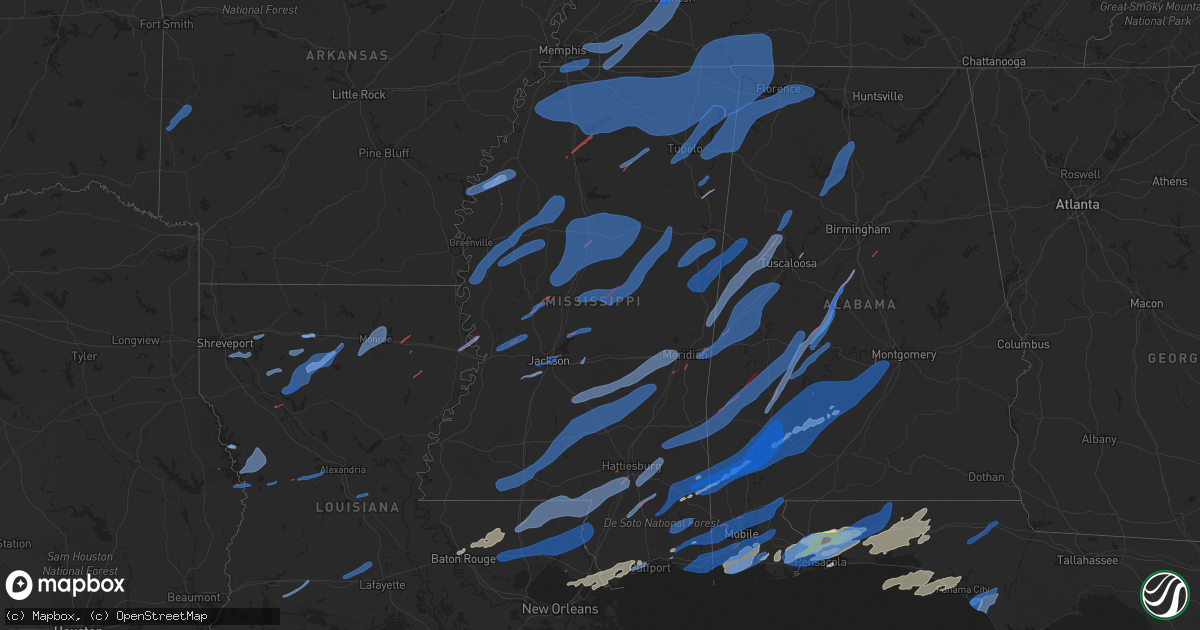
Hail Map in Mississippi on March 30, 2022
Get this storm
March 30 map
$229
one time, instant access
Download today. No call, no setup
Keep the $229
Bought the map and want the full workflow? Apply the entire $229 to a subscription within 7 days. None of it is wasted.
Every map, not just this one
This buys you this map. Subscription and you get every map we run, in the markets you choose from a few cities to whole states to nationwide. Plus real-time alerts the moment a storm fires.
Contact data
Name, contact info, occupancy, even credit band for addresses in the footprint. You go from where it hit to who to call.
Become the source they trust
Unlimited branding weather history reports on demand. You already have the documented answer ready for the property owner, and you are the one who showed up with it.
Property data and RoofTrace estimates
Pull up any address you have got, its value and the exact code rules for that jurisdiction, straight from One Click Code. Then RoofTrace estimates the squares, pitch, and roof value, priced the way you price.
Storm reports in Mississippi
Mississippi
| Date | Description |
|---|---|
| 03/30/20226:52 PM CDT | Trees downed on betheden rd. |
| 03/30/20226:45 PM CDT | Tree down along hwy 25 near the oktibbeha/winston county line. |
| 03/30/20226:43 PM CDT | Tree fell on a home on caldwell st. |
| 03/30/20226:30 PM CDT | Multiple trees down. |
| 03/30/20226:28 PM CDT | Large tree snapped in okalona. |
| 03/30/20226:20 PM CDT | Report of trees down in the silver creek area. |
| 03/30/20226:05 PM CDT | Very large tree down on country club road. |
| 03/30/20226:00 PM CDT | Social media report of a tree down across power lines in the forkville area. |
| 03/30/20225:40 PM CDT | Social media report of a tree across power lines near pelahatchie. |
| 03/30/20225:34 PM CDT | Trees downed across ms hwy 35 near singleton. |
| 03/30/20225:32 PM CDT | Tree downed on a power line north of bellefontaine. Possible tornado. |
| 03/30/20225:30 PM CDT | Several large trees down on hwy 9 near sarepta. |
| 03/30/20225:25 PM CDT | Numerous trees down and shingles missing from home. |
| 03/30/20225:25 PM CDT | Several large tree branches snapped in calhoun county. Also structural damage to buildings on hwy 271... 331... And 253. |
| 03/30/20225:20 PM CDT | Large trees down and roof torn off a shed on hwy 9. |
| 03/30/20225:19 PM CDT | Tree downed across ms hwy 468. |
| 03/30/20225:17 PM CDT | Large trees down across holly springs. |
| 03/30/20225:15 PM CDT | Trees down along monterey rd. |
| 03/30/20225:14 PM CDT | Social media report of trees down in the camden area. |
| 03/30/20225:12 PM CDT | Trees and power lines reported down in the florence area. |
| 03/30/20225:10 PM CDT | Trees were reported down in the gore springs area. |
| 03/30/20225:00 PM CDT | Oliver farm roof lifted off. |
| 03/30/20224:57 PM CDT | Picture of a power line down in the sallis area. |
| 03/30/20224:54 PM CDT | A few trees downed in grenada. |
| 03/30/20224:50 PM CDT | Several large trees down at hwy 315 and hwy 6. Also a roof torn off a shed. |
| 03/30/20224:49 PM CDT | Corrects previous tstm wnd dmg report from 1 n southaven. A roof collapsed on a warehouse at i-55 and stateline rd. |
| 03/30/20224:49 PM CDT | Damage to a warehouse at i-55 and stateline rd. |
| 03/30/20224:48 PM CDT | Report from mping of wind damage similar to broken 1 inch tree limbs... Or shingles blown off. |
| 03/30/20224:48 PM CDT | Fencing blown down at a home in ridgeland. |
| 03/30/20224:45 PM CDT | Power lines... Telephones... And fences blown down on rasco road. |
| 03/30/20224:45 PM CDT | Grain bins that were approximately 200 yards south of hwy 310 destroyed and blown across the road. Broken tree limbs also apparent. Damage is about 100 yards west of th |
| 03/30/20224:45 PM CDT | Estimated wind gust 60mph 3 mi north of sardis lake. Also has trees down around the area. |
| 03/30/20224:44 PM CDT | Tree downed on the central fire station. |
| 03/30/20224:44 PM CDT | Tin from a roof was blown into the road at congress and tombigbee. |
| 03/30/20224:44 PM CDT | Updates previous tornado report from 1 sse jackson. Building damage at silas brown and jefferson... Trees down on commerce st... Large tree down at silas brown and cong |
| 03/30/20224:44 PM CDT | Building damage at silas brown and jefferson. |
| 03/30/20224:43 PM CDT | Utility pole downed at university and daun. |
| 03/30/20224:43 PM CDT | Tree downed on a house on campbell st. |
| 03/30/20224:43 PM CDT | Tree downed on a house on campbell st. |
| 03/30/20224:42 PM CDT | Observed at the jan asos. |
| 03/30/20224:40 PM CDT | Reports of someone trapped in a house... As well as trees and power lines down throughout the county. |
| 03/30/20224:40 PM CDT | A steeple was blown off a church at robinson and ellis. |
| 03/30/20224:39 PM CDT | Large pine tree down at n livingston rd and rouser rd. |
| 03/30/20224:39 PM CDT | Tree downed at lindsey and mccain. |
| 03/30/20224:39 PM CDT | Tree snapped along dorgan st. |
| 03/30/20224:37 PM CDT | Tree downed at robinson rd and colony square. |
| 03/30/20224:37 PM CDT | Tornado confirmed by sky camera on the southwest side of jackson and also heard in the area. |
| 03/30/20224:37 PM CDT | Roof damage to structures on nicholson dr and moncure marble. |
| 03/30/20224:37 PM CDT | Trees were blown down in the vaughan area. |
| 03/30/20224:37 PM CDT | Roof damage to multiple homes on plummer cir. Possible tornado. |
| 03/30/20224:35 PM CDT | Minor roof damage on carriage hills dr and cedarwood dr. |
| 03/30/20224:34 PM CDT | Roof damage to homes on green gable rd... Greystone point... And brookside cove. |
| 03/30/20224:33 PM CDT | Utility poles and a tree downed at davis rd park. Possible tornado. |
| 03/30/20224:31 PM CDT | Report from mping of wind damage similar to broken 3 inch tree limbs... Or power poles broken. Possible tornado damage. |
| 03/30/20224:28 PM CDT | Tree downed at kimbell and mcwilliams. Possible tornado. |
| 03/30/20224:28 PM CDT | Large pine tree across jackson raymond rd on a vehicle. Possible tornado. |
| 03/30/20224:21 PM CDT | Trees downed along dry grove rd between myers and parsons and along myers rd. Possible tornado. |
| 03/30/20224:20 PM CDT | An ag weather site near sidon recorded a 62 mph gust from the wnw. |
| 03/30/20224:13 PM CDT | Social media report of a tree down on power lines in the tchula area. |
| 03/30/20224:11 PM CDT | Several trees and powerlines down in marks and lambert. |
| 03/30/20224:10 PM CDT | Ms hwy 16 blocked by trees with structural damage in benton. |
| 03/30/20224:09 PM CDT | Numerous trees downed at ms hwy 16 and redbud dr. Possible tornado. |
| 03/30/20224:06 PM CDT | Several limbs and trees down along hwy 16 and chew forks rd. |
| 03/30/20224:05 PM CDT | Large tree blocking rusche road near bentonia. |
| 03/30/20224:01 PM CDT | Corrects previous non-tstm wnd dmg report from 4 n little yazoo to tstm wind dmg. Multiple trees downed in the vicinity of us 49 and castle chapel rd. Possible tornado. |
| 03/30/20224:00 PM CDT | Building with roof torn off... Widespread power outages. |
| 03/30/20224:00 PM CDT | Hwy 61 & josephine rd... Power pole snapped and overturned center pivot. |
| 03/30/20223:55 PM CDT | Large treed down on ms hwy 22 west of cox ferry rd. |
| 03/30/20223:54 PM CDT | Tree downed on john warren rd. |
| 03/30/20223:54 PM CDT | Report of multiple trees and powerlines down near the neighborhood of stovall rd. And reservation rd. Trees uprooted and snapped as well as damage to houses and vehicle |
| 03/30/20223:53 PM CDT | Tree and powerline downed at cox ferry and farr. |
| 03/30/20223:48 PM CDT | Trees and power lines downed along askew rd. |
| 03/30/20223:36 PM CDT | Numerous trees and powerlines down around cleveland. Several roads were blocked by trees including yale... Memorial lane and leflore. Roof was blown off of a building. |
| 03/30/20223:28 PM CDT | Person trapped in a mobile in shelby. |
| 03/30/20223:25 PM CDT | Trees across highway 61 near shelby. |
| 03/30/20223:25 PM CDT | Report from mping of wind damage similar to broken 1 inch tree limbs... Or shingles blown off. |
| 03/30/20223:24 PM CDT | Large limbs down near the intersection of reed rd and hwy. 1. |
| 03/30/20223:21 PM CDT | Recorded at cwop site near shelby. Sustained 52 mph... Gusting to 83 mph. Possible tornado. |
| 03/30/20223:14 PM CDT | Trees and powerlines down in gunnison. |
| 03/30/20223:05 PM CDT | Roof blown off a house on lo sto rd on eagle lake. |
| 03/30/20223:04 PM CDT | Trees and powerlines down in rosedale. |
| 03/30/20223:04 PM CDT | 2 trees downed along sea island dr on eagle lake. |
| 03/30/20223:00 PM CDT | Tree uprooted and fell on house. |
| 03/30/20222:15 PM CDT | Roof ripped off hotel. |
| 03/30/20225:49 AM CDT | At 1049 PM CDT, severe thunderstorms were located along a line extending from Calvert to near Grand Bay, moving east at 30 mph. HAZARD...70 mph wind gusts. SOURCE...Radar indicated. IMPACT...Expect considerable tree damage. Damage is likely to mobile homes, roofs, and outbuildings. Locations impacted include... Midtown Mobile, Downtown Mobile, Prichard, Daphne, Tillmans Corner, Fairhope, Saraland, Bay Minette, Atmore, Theodore, Chickasaw, Satsuma, Spanish Fort, Grand Bay, Robertsdale, Creola, Loxley, Stockton, Stapleton and Axis. |
| 03/30/20225:40 AM CDT | At 1039 PM CDT, severe thunderstorms were located along a line extending from 4 miles east of Big Point to 9 miles northeast of Petit Bois Island to 23 miles south of Gautier, moving east at 35 mph. HAZARD...70 mph wind gusts. SOURCE...Radar indicated. IMPACT...Expect considerable tree damage. Damage is likely to mobile homes, roofs, and outbuildings. Locations impacted include... Daphne, Fairhope, Gulf Shores, Foley, Orange Beach, Robertsdale, Bayou La Batre, Point Clear, Dauphin Island, Loxley, Magnolia Springs, Bon Secour, Summerdale, Silverhill, Elberta, Coden, Fort Morgan and Alabama Port. |
| 03/30/20224:53 AM CDT | At 951 PM CDT, severe thunderstorms were located along a line extending from McIntosh to 4 miles east of Lucedale to 5 miles northwest of Vancleave, moving east at 55 mph. THESE ARE DESTRUCTIVE STORMS FOR AGRICOLA...CITRONELLE...WEST MOBILE... HAZARD...80 mph wind gusts. SOURCE...Radar indicated. IMPACT...Flying debris will be dangerous to those caught without shelter. Mobile homes will be heavily damaged. Expect considerable damage to roofs, windows, and vehicles. Extensive tree damage and power outages are likely. Locations impacted include... Midtown Mobile, Downtown Mobile, Prichard, Tillmans Corner, Saraland, Bay Minette, Theodore, Chickasaw, Satsuma, Spanish Fort, Citronelle, Lucedale, Creola, Chunchula, Stockton, McCullough, Stapleton, Gulfcrest, Axis and Mount Vernon. |
| 03/30/20224:25 AM CDT | At 923 PM CDT, severe thunderstorms were located along a line extending from 6 miles east of Millry to near Fruitdale to 8 miles southeast of Leakesville to 10 miles west of Lucedale to 10 miles east of McHenry, moving east at 30 mph. THESE ARE DESTRUCTIVE STORMS FOR CHATOM...FRUITDALE...VINEGAR BEND...LOCAITONS NEAR LEAKESVILLE HAZARD...80 mph wind gusts. SOURCE...Radar indicated. IMPACT...Flying debris will be dangerous to those caught without shelter. Mobile homes will be heavily damaged. Expect considerable damage to roofs, windows, and vehicles. Extensive tree damage and power outages are likely. Locations impacted include... Jackson, Citronelle, Lucedale, Chatom, Leakesville, Saint Stephens, Wagarville, Leroy, McHenry, Gulfcrest, Deer Park, Tibbie, Calvert, Mount Vernon, McLain, Fruitdale, McIntosh and Movico. |
| 03/30/20224:02 AM CDT | At 902 PM CDT, a severe thunderstorm was located near Bay St. Louis, moving east at 45 mph. HAZARD...60 mph wind gusts and nickel size hail. SOURCE...Radar indicated. IMPACT...Expect damage to roofs, siding, and trees. Locations impacted include... Gulfport, Biloxi, Ocean Springs, Long Beach, Bay St. Louis, Waveland, St. Martin, Diamondhead, D'iberville, Latimer, Lyman, Gulf Hills, Shoreline Park and Gulfport Airport.This includes the following Interstates... Interstate 10 in Mississippi between mile markers 16 and 51. Interstate 110 in Mississippi between mile markers 3 and 4. |
| 03/30/20223:06 AM CDT | At 805 PM CDT, a severe thunderstorm was located over New Orleans, moving east at 40 mph. HAZARD...70 mph wind gusts. SOURCE...Radar indicated. IMPACT...Expect considerable tree damage. Damage is likely to mobile homes, roofs, and outbuildings. Locations impacted include... New Orleans, Chalmette, Avondale, Marrero, Harvey, East New Orleans, Timberlane, Belle Chasse, Metairie, Jefferson, Gretna, Harahan, Westwego, Lake Catherine, Luling, Poydras, Estelle, Woodmere, Elmwood and Violet.This includes the following Interstates... Interstate 10 in Louisiana between mile markers 232 and 254. Interstate 510 between mile markers 1 and 3. Interstate 610 between mile markers 1 and 4. |
| 03/30/20223:00 AM CDT | At 800 PM CDT, a severe thunderstorm was located 8 miles east of Poplarville, moving northeast at 50 mph. HAZARD...60 mph wind gusts. SOURCE...Radar indicated. IMPACT...Expect damage to roofs, siding, and trees. Locations impacted include... Brooklyn and Maxie. |
| 03/30/20222:50 AM CDT | At 749 PM CDT, severe thunderstorms were located along a line extending from West Hattiesburg to 5 miles southeast of Lumberton to 6 miles south of Poplarville to 3 miles northwest of Picayune to 6 miles northwest of Lacombe, moving northeast at 55 mph. HAZARD...60 mph wind gusts. SOURCE...Radar indicated. IMPACT...Expect damage to roofs, siding, and trees. Locations impacted include... Wiggins, Richton, Perkinston, McHenry, Beaumont, New Augusta and McLain. |
| 03/30/20222:30 AM CDT | At 730 PM CDT, a severe thunderstorm was located near Forestdale, or 11 miles east of Philadelphia, moving northeast at 70 mph. HAZARD...60 mph wind gusts. SOURCE...Radar indicated. IMPACT...Expect damage to roofs, siding, and trees. This severe thunderstorm will be near... Bluff Springs around 735 PM CDT. Preston around 740 PM CDT. Gholson around 745 PM CDT. Macon and Paulette around 800 PM CDT. Prairie Point around 810 PM CDT.Other locations impacted by this severe thunderstorm includeShuqualak and Scooba. |
| 03/30/20222:22 AM CDT | At 721 PM CDT, severe thunderstorms were located along a line extending from near New Salem to Sessums, moving northeast at 60 mph. HAZARD...60 mph wind gusts. SOURCE...Radar indicated. IMPACT...Expect damage to roofs, siding, and trees. Locations impacted include... Amory, Aberdeen, Fulton, Smithville, Tremont, Prairie, Fairview, New Salem, Sandy Springs, New Wren, Evergreen, Clay, Hatley, Gattman, Abney, Eastman, Quincy, Turon, Wise Gap and Wren. |
| 03/30/20222:18 AM CDT | At 718 PM CDT, severe thunderstorms were located along a line extending from near Smithville to 6 miles southwest of Brooksville, moving northeast at 55 mph. HAZARD...60 mph wind gusts. SOURCE...Radar indicated. IMPACT...Expect damage to roofs, siding, and trees. Locations impacted include... Hamilton, Winfield, Vernon, Sulligent, Millport, Guin, Hackleburg, Kennedy, Detroit, Belk, Beaverton, Gu- Win, Weston, Bluff, Blooming Grove, Lamar County Airport, Brinn, Crews, Bedford and Bear Creek. |
| 03/30/20222:16 AM CDT | At 716 PM CDT, a severe thunderstorm was located 7 miles southeast of Taylorsville, or 9 miles southwest of Stringer, moving east at 40 mph. HAZARD...60 mph wind gusts. SOURCE...Radar indicated. IMPACT...Expect damage to roofs, siding, and trees. This severe thunderstorm will be near... Sandersville around 745 PM CDT.Other locations impacted by this severe thunderstorm include Soso. |
| 03/30/20222:04 AM CDT | At 704 PM CDT, severe thunderstorms were located along a line extending from near Roberts to near Taylorsville, moving east at 45 mph. HAZARD...60 mph wind gusts. SOURCE...Radar indicated. IMPACT...Expect damage to roofs, siding, and trees. Severe thunderstorms will be near... Lawrence and Roberts around 710 PM CDT. Garlandville around 715 PM CDT. Newton around 720 PM CDT. Stringer and Bay Springs around 725 PM CDT. Vernon, Moss and Turnerville around 730 PM CDT. Heidelberg, Stafford Springs and Paulding around 745 PM CDT.Other locations impacted by these severe thunderstorms includeSylvarena, Chunky, Lake, Montrose, Louin and Hickory. |
| 03/30/20221:53 AM CDT | At 653 PM CDT, severe thunderstorms were located along a line extending from near Prairie to near Millcreek, moving northeast at 60 mph. HAZARD...60 mph wind gusts. SOURCE...Radar indicated. IMPACT...Expect damage to roofs, siding, and trees. Severe thunderstorms will be near... Crawford and Oktoc around 710 PM CDT. Sessums around 715 PM CDT. Bent Oak around 720 PM CDT. Tibbee around 725 PM CDT. Columbus and Waverly around 730 PM CDT. Columbus AFB and Steens around 735 PM CDT. Caledonia and Kolola Springs around 740 PM CDT.Other locations impacted by these severe thunderstorms includeArtesia. |
| 03/30/20221:53 AM CDT | At 653 PM CDT, severe thunderstorms were located along a line extending from near Enon to 6 miles northwest of Covington to 7 miles south of Ponchatoula, moving east at 35 mph. HAZARD...60 mph wind gusts. SOURCE...Radar indicated. IMPACT...Expect damage to roofs, siding, and trees. Locations impacted include... Slidell, Picayune, Covington, Pearl River, Abita Springs, Madisonville, Folsom, Sun, Bush, Lacombe, Mcneil and Slidell Airport.This includes the following Interstates... Interstate 12 between mile markers 49 and 82. Interstate 55 in Louisiana between mile markers 15 and 23. Interstate 59 in Louisiana between mile markers 5 and 11. Interstate 59 in Mississippi between mile markers 1 and 11. |
| 03/30/20221:49 AM CDT | At 649 PM CDT, severe thunderstorms were located along a line extending from 6 miles south of Raleigh to near Lone Star to near Society Hill, moving east at 35 mph. HAZARD...60 mph wind gusts. SOURCE...Radar indicated. IMPACT...Expect damage to roofs, siding, and trees. Severe thunderstorms will be near... Center Ridge around 700 PM CDT. Collins around 705 PM CDT. Melba around 710 PM CDT. Sanford around 730 PM CDT.Other locations impacted by these severe thunderstorms includeBassfield, Seminary and Mize. |
| 03/30/20221:47 AM CDT | At 646 PM CDT, severe thunderstorms were located along a line extending from near Adamsville to near Evergreen, moving northeast at 55 mph. HAZARD...60 mph wind gusts. SOURCE...Radar indicated. IMPACT...Expect damage to roofs, siding, and trees. Locations impacted include... Florence, Muscle Shoals, Russellville, Sheffield, Tuscumbia, Red Bay, Phil Campbell, Cherokee, Underwood-Petersville and Belgreen. |
| 03/30/20221:42 AM CDT | At 642 PM CDT, severe thunderstorms were located along a line extending from 6 miles northeast of Mount Herman to 7 miles northwest of Folsom, moving east at 45 mph. HAZARD...60 mph wind gusts. SOURCE...Radar indicated. IMPACT...Expect damage to roofs, siding, and trees. Locations impacted include... Bogalusa, Franklinton, Varnado, Enon, Crossroads, Dexter, Mount Herman and Angie. |
| 03/30/20221:39 AM CDT | At 638 PM CDT, severe thunderstorms were located along a line extending from 7 miles southwest of Shiloh to Thrashers to near Mantachie, moving northeast at 50 mph. HAZARD...60 mph wind gusts. SOURCE...Radar indicated. IMPACT...Expect damage to roofs, siding, and trees. Locations impacted include... Corinth, Booneville, Savannah, Selmer, Baldwyn, Iuka, Pickwick Landing State Park, J P Coleman State Park, Tishomingo State Park, Adamsville, Belmont, Burnsville, Jumpertown, Glen, Tishomingo, Pickwick Dam, Pineflat, Hinkle, Wheeler and Thrashers. |
| 03/30/20221:37 AM CDT | At 636 PM CDT, severe thunderstorms were located along a line extending from near Saltillo to near Shannon to Griffith, moving northeast at 55 mph. HAZARD...60 mph wind gusts. SOURCE...Radar indicated. IMPACT...Expect damage to roofs, siding, and trees. Locations impacted include... Tupelo, Amory, Aberdeen, Fulton, Baldwyn, Verona, Okolona, Tombigbee State Park, Saltillo, Guntown, Shannon, Plantersville, Mantachie, Smithville, Tremont, Prairie, Fairview, Pratts Friendship, New Salem and Sandy Springs. |
| 03/30/20221:29 AM CDT | At 627 PM CDT, severe thunderstorms were located along a line extending from Steele to near Martinville, moving east at 30 mph. HAZARD...60 mph wind gusts. SOURCE...Radar indicated. IMPACT...Expect damage to roofs, siding, and trees. Severe thunderstorms will be near... Harperville and Steele around 635 PM CDT. Conehatta around 645 PM CDT. Prospect around 650 PM CDT. Raleigh and Burns around 655 PM CDT. Stratton around 700 PM CDT. Pineville around 715 PM CDT.Other locations impacted by these severe thunderstorms includeSylvarena, Polkville, Lake, Sebastopol and Puckett. |
| 03/30/20221:14 AM CDT | At 613 PM CDT, severe thunderstorms were located along a line extending from near Pinola to near Hebron to near Topeka, moving east at 30 mph. HAZARD...60 mph wind gusts. SOURCE...Radar indicated. IMPACT...Expect damage to roofs, siding, and trees. Severe thunderstorms will be near... Pinola and Shivers around 620 PM CDT. Sanatorium around 630 PM CDT. Magee around 635 PM CDT. Clem and Progress around 640 PM CDT. Prentiss, Society Hill and Lone Star around 645 PM CDT. Mount Olive and Carson around 655 PM CDT.Other locations impacted by these severe thunderstorms include NewHebron and Silver Creek. |
| 03/30/20221:05 AM CDT | At 605 PM CDT, severe thunderstorms were located along a line extending from near Houston to 7 miles west of Center Ridge, moving northeast at 60 mph. HAZARD...60 mph wind gusts. SOURCE...Radar indicated. IMPACT...Expect damage to roofs, siding, and trees. Severe thunderstorms will be near... Millcreek around 620 PM CDT. Betheden around 625 PM CDT. Craig Springs around 630 PM CDT. Oktoc and Longview around 635 PM CDT. Starkville around 640 PM CDT. Sessums around 645 PM CDT. Tibbee and Muldrow around 650 PM CDT. West Point around 655 PM CDT.Other locations impacted by these severe thunderstorms include Manteeand Sturgis. |
| 03/30/202212:59 AM CDT | At 559 PM CDT, severe thunderstorms were located along a line extending from 8 miles south of Bolivar to New Albany, moving northeast at 55 mph. HAZARD...60 mph wind gusts. SOURCE...Radar indicated. IMPACT...Expect damage to roofs, siding, and trees. Locations impacted include... Corinth, Booneville, New Albany, Henderson, Bolivar, Ripley, Selmer, Baldwyn, Big Hill Pond State Park, Adamsville, Blue Mountain, Jumpertown, Glen, Snow Lake Shores, Silerton, Masseyville, Theo, Canaan, Pocahontas and Hinkle. |
| 03/30/202212:56 AM CDT | At 556 PM CDT, severe thunderstorms were located along a line extending from near Ecru to near Houlka to 8 miles west of Montpelier, moving northeast at 55 mph. HAZARD...60 mph wind gusts. SOURCE...Radar indicated. IMPACT...Expect damage to roofs, siding, and trees. Locations impacted include... Tupelo, Pontotoc, Houston, Baldwyn, Verona, Okolona, Trace State Park, Tombigbee State Park, Saltillo, Guntown, Shannon, Plantersville, Ecru, New Harmony, Pratts Friendship, Troy, Pyland, New Wren, Trebloc and Blair. |
| 03/30/202212:44 AM CDT | At 543 PM CDT, severe thunderstorms were located along a line extending from near Smithdale to near Gillsberg, moving east at 45 mph. HAZARD...60 mph wind gusts. SOURCE...Radar indicated. IMPACT...Expect damage to roofs, siding, and trees. Locations impacted include... Mccomb, Magnolia, Summit, Tylertown, Osyka, Smithdale, Salem, Gillsberg and Mccomb Airport.This includes Interstate 55 in Mississippi between mile markers 1 and24. |
| 03/30/202212:44 AM CDT | At 544 PM CDT, severe thunderstorms were located along a line extending from near Leesburg to near Harrisville, moving east at 40 mph. HAZARD...60 mph wind gusts. SOURCE...Radar indicated. IMPACT...Expect damage to roofs, siding, and trees. Severe thunderstorms will be near... Forkville, Ludlow, Branch and Leesburg around 550 PM CDT. Cato around 600 PM CDT. Harperville and Hillsboro around 605 PM CDT. Martinville and Steele around 610 PM CDT. White Oak around 620 PM CDT. Burns around 630 PM CDT.Other locations impacted by these severe thunderstorms includePolkville, D'Lo, Sebastopol, Braxton and Puckett. |
| 03/30/202212:25 AM CDT | At 525 PM CDT, severe thunderstorms were located along a line extending from near Hopewell to near West Lincoln, moving east at 35 mph. HAZARD...60 mph wind gusts. SOURCE...Radar indicated. IMPACT...Expect damage to roofs, siding, and trees. Severe thunderstorms will be near... Union around 540 PM CDT. East Lincoln around 545 PM CDT. Pinola around 555 PM CDT. Sontag around 600 PM CDT. Monticello and Wanilla around 605 PM CDT.Other locations impacted by these severe thunderstorms includeBeauregard, New Hebron and Georgetown. |
| 03/30/202212:23 AM CDT | At 523 PM CDT, severe thunderstorms were located along a line extending from near Hesterville to 6 miles west of Carthage, moving northeast at 50 mph. HAZARD...60 mph wind gusts. SOURCE...Radar indicated. IMPACT...Expect damage to roofs, siding, and trees. Severe thunderstorms will be near... Renfroe around 540 PM CDT. Smyrna around 545 PM CDT. Zama around 550 PM CDT. Ackerman around 600 PM CDT. Mcmillan around 615 PM CDT.Other locations impacted by these severe thunderstorms includeMccool, Weir and Ethel. |
| 03/30/202212:21 AM CDT | At 520 PM CDT, severe thunderstorms were located along a line extending from near Wall Doxey State Park to near Denmark to 7 miles west of Pittsboro, moving northeast at 60 mph. HAZARD...70 mph wind gusts. SOURCE...Radar indicated. IMPACT...Expect considerable tree damage. Damage is likely to mobile homes, roofs, and outbuildings. Locations impacted include... Tupelo, New Albany, Pontotoc, Houston, Baldwyn, Verona, Okolona, Trace State Park, Saltillo, Guntown, Bruce, Calhoun City, Shannon, Vardaman, Plantersville, Derma, Ecru, Pittsboro, Slate Springs and Cambridge. |
| 03/30/202212:18 AM CDT | At 518 PM CDT, a severe thunderstorm was located near Baker, moving northeast at 60 mph. HAZARD...60 mph wind gusts. SOURCE...Radar indicated. IMPACT...Expect damage to roofs, siding, and trees. Locations impacted include... Baton Rouge, Zachary, Baker, Denham Springs, Port Allen, Clinton, Greensburg, Addis, Brusly, Slaughter, Montpelier, Merrydale, Watson, Darlington, Pride, Brownfields, Greenwell Spring, Easleyville and Baton Rouge Airport.This includes the following Interstates... Interstate 10 in Louisiana between mile markers 148 and 160. Interstate 12 near mile marker 1. Interstate 110 in Louisiana between mile markers 1 and 8. |
| 03/29/202211:45 PM CDT | At 444 PM CDT, severe thunderstorms were located along a line extending from near Como to near George Payne State Park to near Bew Springs, moving east at 50 mph. HAZARD...60 mph wind gusts. SOURCE...Radar indicated. IMPACT...Expect damage to roofs, siding, and trees. Locations impacted include... Oxford, Batesville, Water Valley, George Payne State Park, Holly Springs National Forest, John W Kyle State Park, Bruce, Calhoun City, Sardis, Vardaman, Como, Derma, Coffeeville, Pope, Pittsboro, Slate Springs, Enid, Sabougla, Cambridge and Harmontown. |
| 03/29/202211:42 PM CDT | At 442 PM CDT, severe thunderstorms were located along a line extending from near T O Fuller State Park to near Eudora to near Senatobia, moving northeast at 45 mph. HAZARD...60 mph wind gusts. SOURCE...Radar indicated. IMPACT...Expect damage to roofs, siding, and trees. Locations impacted include... Bartlett, Southaven, Collierville, Germantown, Olive Branch, West Memphis, Horn Lake, Hernando, Marion, Millington, Senatobia, T O Fuller State Park, Meeman Shelby Forest State Park, Cordova, Memphis, Lakeland, Arlington, Coldwater, Byhalia and Walls. |
| 03/29/202211:38 PM CDT | At 438 PM CDT, severe thunderstorms were located along a line extending from near Scobey to near Coila, moving northeast at 45 mph. HAZARD...60 mph wind gusts. SOURCE...Radar indicated. IMPACT...Expect damage to roofs, siding, and trees. Severe thunderstorms will be near... Duck Hill around 505 PM CDT. Misterton around 515 PM CDT. |
| 03/29/202211:30 PM CDT | At 430 PM CDT, severe thunderstorms were located along a line extending from near Fayette to near Bude, moving east at 45 mph. HAZARD...60 mph wind gusts. SOURCE...Radar indicated. IMPACT...Expect damage to roofs, siding, and trees. Locations impacted include... Brookhaven, Hazlehurst, Wesson, Bude, Enterprise, Union Church, Caseyville, Peyton, Mccall Creek, Bogue Chitto, West Lincoln, Little Springs, Red Lick, Center Point, Kirby, Martinsville, New Hope, Blue Hill, Allen and Vaughn. |
| 03/29/202211:24 PM CDT | At 424 PM CDT, severe thunderstorms were located along a line extending from near Ebenezer to 6 miles southeast of Myrleville to near Annandale, moving northeast at 40 mph. HAZARD...60 mph wind gusts. SOURCE...Radar indicated. IMPACT...Expect damage to roofs, siding, and trees. Severe thunderstorms will be near... Canton around 435 PM CDT. Way around 440 PM CDT. Sharon around 450 PM CDT. Cameron and Camden around 455 PM CDT. Farmhaven around 500 PM CDT. |
| 03/29/202211:13 PM CDT | At 412 PM CDT, a severe thunderstorm was located near Morganza, or 7 miles northeast of Melville, moving northeast at 55 mph. HAZARD...60 mph wind gusts. SOURCE...Radar indicated. IMPACT...Expect damage to roofs, siding, and trees. Locations impacted include... New Roads, Jackson, St. Francisville, Centreville, Livonia, Woodville, Slaughter, Fordoche, Morganza, Wilson, Norwood, Wakefield, Spillman, Batchelor and Lottie. |
| 03/29/202210:59 PM CDT | At 359 PM CDT, severe thunderstorms were located along a line extending from near Brownsville to near Peyton, moving east at 25 mph. HAZARD...60 mph wind gusts. SOURCE...Radar indicated. IMPACT...Expect damage to roofs, siding, and trees. Severe thunderstorms will be near... Bolton around 405 PM CDT. Brownsville around 410 PM CDT. Clinton around 425 PM CDT. Pocahontas around 430 PM CDT. Dentville around 435 PM CDT. Annandale around 445 PM CDT. Madison and Ridgeland around 455 PM CDT. Crystal Springs, Gallman and Gluckstadt around 500 PM CDT.Other locations impacted by these severe thunderstorms includeLearned. |
| 03/29/202210:57 PM CDT | At 357 PM CDT, severe thunderstorms were located along a line extending from near Dublin to near Sumner to 6 miles east of Drew, moving northeast at 60 mph. HAZARD...70 mph wind gusts. SOURCE...Radar indicated. IMPACT...Expect considerable tree damage. Damage is likely to mobile homes, roofs, and outbuildings. Locations impacted include... Batesville, Charleston, George Payne State Park, Tutwiler, Marks, Sardis, Lambert, Como, Crowder, Webb, Sledge, Sumner, Pope, Belen, Enid, Paynes, Pleasant Grove, Curtis Station, Vance and Darling. |
| 03/29/202210:47 PM CDT | At 347 PM CDT, severe thunderstorms were located along a line extending from Sunflower to near Midnight, moving northeast at 45 mph. HAZARD...60 mph wind gusts. SOURCE...Radar indicated. IMPACT...Expect damage to roofs, siding, and trees. Severe thunderstorms will be near... Swiftown around 405 PM CDT. Tchula around 410 PM CDT. Money around 415 PM CDT. Sidon around 425 PM CDT. Black Hawk and Seven Pines around 430 PM CDT. Coila around 440 PM CDT. Malmaison around 445 PM CDT. North Carrollton around 450 PM CDT.Other locations impacted by these severe thunderstorms include MorganCity, Cruger and Carrollton. |
| 03/29/202210:20 PM CDT | At 320 PM CDT, severe thunderstorms were located along a line extending from near Sherard to near Holly Ridge, moving northeast at 50 mph. HAZARD...60 mph wind gusts. SOURCE...Radar indicated. IMPACT...Expect damage to roofs, siding, and trees. Severe thunderstorms will be near... Sunflower around 340 PM CDT. Blaine around 345 PM CDT. Ruleville around 350 PM CDT. Drew around 355 PM CDT. Sunnyside around 400 PM CDT. Minter City around 405 PM CDT.Other locations impacted by these severe thunderstorms includeSchlater and Doddsville. |
| 03/29/202210:09 PM CDT | At 308 PM CDT, severe thunderstorms were located along a line extending from near Monterey to near Whiteville, moving east at 25 mph. HAZARD...60 mph wind gusts. SOURCE...Radar indicated. IMPACT...Expect damage to roofs, siding, and trees. Locations impacted include... Morganza, Fort Adams, Dolorosa, Lettsworth and Batchelor. |
| 03/29/202210:04 PM CDT | At 303 PM CDT, severe thunderstorms were located along a line extending from near Spokane to 6 miles northwest of Black Hawk, moving northeast at 40 mph. HAZARD...60 mph wind gusts. SOURCE...Radar indicated. IMPACT...Expect damage to roofs, siding, and trees. Locations impacted include... Natchez, Vidalia, Waterproof, Stanton, Kingston, Black Hawk, Lorman, Sibley, Slocum, Spokane, Cranfield, Stampley, Deer Park, Church Hill and Ridgecrest. |
| 03/29/20229:55 PM CDT | Reports of damage to a roof. *possible tornado damage*. |
| 03/29/20229:53 PM CDT | Reports of two houses damaged. *possible tornado damage*. |
| 03/29/20229:21 PM CDT | At 221 PM CDT, severe thunderstorms were located along a line extending from near Bakers to Larto, moving east at 45 mph. HAZARD...60 mph wind gusts. SOURCE...Radar indicated. IMPACT...Expect damage to roofs, siding, and trees. Severe thunderstorms will be near... Bakers around 225 PM CDT. Monterey and Tendal around 235 PM CDT. Deer Park and Afton around 245 PM CDT. Tallulah and Mansford around 250 PM CDT.Other locations impacted by these severe thunderstorms include Mound,Gilbert, Sicily Island, Delta, Ridgecrest and Richmond. |
| 03/29/20229:17 PM CDT | Reports of trees down. |
| 03/29/20228:46 PM CDT | Numerous power lines and trees down in the mclain community. Reports of trees and debris over old highway 24. Tds observed on radar. Time estimated. |
| 03/29/20228:42 PM CDT | Multiple homes were reported to have roof damage in mclain. Roof damage also reported in nearby perry county. |
| 03/29/20228:33 PM CDT | Trees and power lines downed on shelby gressett. |
| 03/29/20228:18 PM CDT | A mobile home was damaged on tom bennett rd. |
| 03/29/20228:15 PM CDT | Report from mping of wind damage similar to trees snapped or uprooted... Or roof blown off. Possible tornado damage. |
| 03/29/20228:12 PM CDT | Powerlines downed near prairie point rd. |
| 03/29/20228:05 PM CDT | Few trees down on highway 26 at lake toc-o-leen and highway 26 at magnolia road. Time estimated. |
| 03/29/20228:03 PM CDT | There was some shingle damage and a snapped tree near a house in the basic city to enterprise area. Possible tornado damage. |
| 03/29/20228:00 PM CDT | Minor street flooding off royal oak road. |
| 03/29/20227:54 PM CDT | A tree fell into the road along us highway 49... And a driver was later injured after crashing into the fallen tree. |
| 03/29/20227:49 PM CDT | Wcbi article reports several trees down in the columbus area. |
| 03/29/20227:45 PM CDT | Significant line wind damage... Possible tornado track. |
| 03/29/20227:44 PM CDT | Several trees snapped... Including a tree on a home... And power lines downed on ford loop. Trees also down along ms hwy 589. Possible tornado. |
| 03/29/20227:30 PM CDT | Significant wind damage. Possible tornado track. |
| 03/29/20227:30 PM CDT | Vehicle trapped beneath trees and power lines on hwy 178 near nita lake road west of tremont. |
| 03/29/20227:20 PM CDT | Large tree down |
| 03/29/20227:17 PM CDT | Radar indicated brief tornado touchdown. Very small circulation but confirmed tds on radar. |
| 03/29/20227:15 PM CDT | Roof partially lifted off house. |
| 03/29/20227:00 PM CDT | Power line poles snapped in half. |
| 03/29/20227:00 PM CDT | Tree downed on church. |
| 03/29/20227:00 PM CDT | Tree downed on apartment 103. |
| 03/29/20227:00 PM CDT | Oak tree downed on trailer. |
| 03/29/20227:00 PM CDT | Tree downed on house. |
| 03/29/20227:00 PM CDT | Tree downed on mobile home. |
| 03/29/20227:00 PM CDT | Downed trees and powerlines. |
All States Impacted by Hail Map on March 30, 2022
Cities Impacted by Hail Map on March 30, 2022
- Milton, FL
- Cantonment, FL
- Diamondhead, MS
- Port Allen, LA
- Baton Rouge, LA
- Defuniak Springs, FL
- Panama City Beach, FL
- Panama City, FL
- Inlet Beach, FL
- Santa Rosa Beach, FL
- Summerdale, AL
- Vredenburgh, AL
- Franklin, AL
- Peterman, AL
- Beatrice, AL
- Pass Christian, MS
- Bagdad, FL
- Robertsdale, AL
- Holt, FL
- Pensacola, FL
- Elberta, AL
- Lillian, AL
- Seminole, AL
- Eglin Afb, FL
- Whatley, AL
- Jackson, AL
- Grove Hill, AL
- Gainestown, AL
- Theriot, LA
- Freeport, FL
- Ponce De Leon, FL
- Foley, AL
- Pine Apple, AL
- Leakesville, MS
- Niceville, FL
- Westville, FL
- Valparaiso, FL
- Crestview, FL
- Moss Point, MS
- Citronelle, AL
- Deer Park, AL
- Zachary, LA
- Holden, LA
- Greenwell Springs, LA
- Pride, LA
- Amite, LA
- Pine Grove, LA
- Walker, LA
- Denham Springs, LA
- Baker, LA
- Fairhope, AL
- Vancleave, MS
- Gulf Breeze, FL
- Coden, AL
- Bayou La Batre, AL
- Daphne, AL
- Theodore, AL
- Irvington, AL
- Long Beach, MS
- Gulfport, MS
- Waveland, MS
- Kiln, MS
- Pearlington, MS
- Bay Saint Louis, MS
- Slidell, LA
- New Orleans, LA
- Lucedale, MS
- McIntosh, AL
- Sunflower, AL
- Tibbie, AL
- Wagarville, AL
- Vinegar Bend, AL
- Echola, AL
- Eutaw, AL
- Berry, AL
- Aliceville, AL
- Porterville, MS
- Coker, AL
- Northport, AL
- Buhl, AL
- Elrod, AL
- Scooba, MS
- Carrollton, AL
- Gordo, AL
- Emelle, AL
- Epes, AL
- Cuba, AL
- Meridian, MS
- Forkland, AL
- Boligee, AL
- Akron, AL
- Livingston, AL
- Knoxville, AL
- Gainesville, AL
- Moundville, AL
- Toomsuba, MS
- York, AL
- Fosters, AL
- Lawley, AL
- Selma, AL
- Uniontown, AL
- Thomasville, AL
- Randolph, AL
- Marion, AL
- Thomaston, AL
- Marion Junction, AL
- Centreville, AL
- Montevallo, AL
- Brierfield, AL
- Safford, AL
- Catherine, AL
- Arlington, AL
- Pine Hill, AL
- Reform, AL
- Ethelsville, AL
- Shuqualak, MS
- Brooksville, MS
- Macon, MS
- Dennis, MS
- Mantachie, MS
- Tremont, MS
- Vina, AL
- Russellville, AL
- Cherokee, AL
- Muscle Shoals, AL
- Golden, MS
- Belmont, MS
- Town Creek, AL
- Courtland, AL
- Tuscumbia, AL
- Rogersville, AL
- Hillsboro, AL
- Red Bay, AL
- Sheffield, AL
- Fulton, MS
- Killen, AL
- Leighton, AL
- Nettleton, MS
- Dixons Mills, AL
- Campbell, AL
- Faunsdale, AL
- Coffeeville, AL
- Butler, AL
- Buckatunna, MS
- Gilbertown, AL
- Richton, MS
- Toxey, AL
- Magnolia, AL
- Millry, AL
- Waynesboro, MS
- Linden, AL
- Sweet Water, AL
- Newbern, AL
- Silas, AL
- Laurel, MS
- Bremen, AL
- Arley, AL
- Logan, AL
- Falkville, AL
- Cullman, AL
- Jasper, AL
- Vinemont, AL
- Crane Hill, AL
- Alberta, AL
- Orrville, AL
- Wilmer, AL
- Creola, AL
- Semmes, AL
- Eight Mile, AL
- Satsuma, AL
- Mobile, AL
- Bay Minette, AL
- Saraland, AL
- Perdido, AL
- Pascagoula, MS
- Stapleton, AL
- Loxley, AL
- Ocean Springs, MS
- Grand Bay, AL
- Gautier, MS
- Elm Grove, LA
- Shreveport, LA
- Bossier City, LA
- Doyline, LA
- Minden, LA
- Castor, LA
- Ringgold, LA
- Coushatta, LA
- Hall Summit, LA
- Burkeville, TX
- Anacoco, LA
- Florien, LA
- Hornbeck, LA
- Bienville, LA
- Jonesboro, LA
- Ruston, LA
- Choudrant, LA
- Saline, LA
- Quitman, LA
- Chatham, LA
- Eros, LA
- Goldonna, LA
- Simsboro, LA
- Arcadia, LA
- Leesville, LA
- Sieper, LA
- Elmer, LA
- Otis, LA
- Boyce, LA
- West Monroe, LA
- Monroe, LA
- Iowa, LA
- Bell City, LA
- Welsh, LA
- Cheneyville, LA
- Tallulah, LA
- Vicksburg, MS
- Church Point, LA
- Crowley, LA
- Sunset, LA
- Branch, LA
- Rayne, LA
- Iota, LA
- Covington, LA
- Folsom, LA
- Carriere, MS
- Albany, LA
- Springfield, LA
- Poplarville, MS
- Livingston, LA
- Bush, LA
- Hammond, LA
- Ponchatoula, LA
- Picayune, MS
- Franklinton, LA
- Bogalusa, LA
- Tickfaw, LA
- Loranger, LA
- Robert, LA
- Abita Springs, LA
- Roseland, LA
- Columbia, MS
- Mount Hermon, LA
- Purvis, MS
- Hattiesburg, MS
- Independence, LA
- Angie, LA
- Kentwood, LA
- Lumberton, MS
- Tylertown, MS
- Sandy Hook, MS
- Many, LA
- Oakfield, TN
- Mercer, TN
- Lavinia, TN
- Jackson, TN
- Denmark, TN
- Toone, TN
- Moscow, TN
- Arlington, TN
- Milan, TN
- Eads, TN
- Somerville, TN
- Whiteville, TN
- Holly Springs, MS
- Williston, TN
- Rossville, TN
- Cordova, TN
- Medina, TN
- Collierville, TN
- Humboldt, TN
- Oakland, TN
- Byhalia, MS
- Bolivar, TN
- Medon, TN
- Olive Branch, MS
- Memphis, TN
- Germantown, TN
- Horn Lake, MS
- Southaven, MS
- Walls, MS
- Gracey, KY
- Fort Campbell, KY
- Cadiz, KY
- Bumpus Mills, TN
- Cerulean, KY
- Hopkinsville, KY
- Springville, TN
- Herndon, KY
- Crofton, KY
- Stewart, TN
- Paris, TN
- La Fayette, KY
- Big Sandy, TN
- Dover, TN
- Big Rock, TN
- Linden, TN
- Eva, TN
- Waverly, TN
- Sugar Tree, TN
- Holladay, TN
- Lobelville, TN
- Hollow Rock, TN
- New Johnsonville, TN
- Woodlawn, TN
- Cunningham, TN
- Parsons, TN
- Erin, TN
- Vanleer, TN
- Dickson, TN
- Palmyra, TN
- Bruceton, TN
- McEwen, TN
- Nunnelly, TN
- Buena Vista, TN
- Only, TN
- Cumberland City, TN
- Hurricane Mills, TN
- Indian Mound, TN
- Centerville, TN
- Cumberland Furnace, TN
- Tennessee Ridge, TN
- Camden, TN
- Charlotte, TN
- Thompsons Station, TN
- Brentwood, TN
- Franklin, TN
- Minter City, MS
- Itta Bena, MS
- Holcomb, MS
- Greenwood, MS
- Leland, MS
- Charleston, MS
- Philipp, MS
- Chatham, MS
- Sunflower, MS
- Glen Allan, MS
- Inverness, MS
- Schlater, MS
- Hollandale, MS
- Moorhead, MS
- Indianola, MS
- Greenville, MS
- Belzoni, MS
- Sidon, MS
- Isola, MS
- Duncan, MS
- Rosedale, MS
- Mound Bayou, MS
- Tutwiler, MS
- Watson, AR
- Shelby, MS
- Clarksdale, MS
- Gunnison, MS
- Bolton, MS
- Flora, MS
- Bentonia, MS
- Yazoo City, MS
- Benton, MS
- Byram, MS
- Raymond, MS
- Utica, MS
- Terry, MS
- West, MS
- French Camp, MS
- Kilmichael, MS
- Coila, MS
- Durant, MS
- Eupora, MS
- Walthall, MS
- Duck Hill, MS
- Vaiden, MS
- Stewart, MS
- Cruger, MS
- Ackerman, MS
- Ethel, MS
- Winona, MS
- Lexington, MS
- Mathiston, MS
- McCarley, MS
- North Carrollton, MS
- Weir, MS
- Carrollton, MS
- Jackson, MS
- Flowood, MS
- Pearl, MS
- Lena, MS
- Canton, MS
- Brandon, MS
- Stantonville, TN
- Tupelo, MS
- Crump, TN
- Olivehill, TN
- Crenshaw, MS
- Hickory Flat, MS
- Glen, MS
- Thaxton, MS
- Batesville, MS
- Abbeville, MS
- Iuka, MS
- Iron City, TN
- Ecru, MS
- Sardis, MS
- Adamsville, TN
- Burnsville, MS
- Myrtle, MS
- Lutts, TN
- Lamar, MS
- Dundee, MS
- Hernando, MS
- Michigan City, MS
- Ripley, MS
- Selmer, TN
- Shiloh, TN
- Etta, MS
- Blue Springs, MS
- Blue Mountain, MS
- Cypress Inn, TN
- Falkner, MS
- Tiplersville, MS
- Savannah, TN
- Dumas, MS
- Counce, TN
- Senatobia, MS
- Waynesboro, TN
- Baldwyn, MS
- Rienzi, MS
- Florence, AL
- Michie, TN
- Como, MS
- Potts Camp, MS
- Waterford, MS
- Red Banks, MS
- Saltillo, MS
- Coldwater, MS
- Booneville, MS
- Ashland, MS
- Marietta, MS
- Oxford, MS
- Guys, TN
- Sarah, MS
- Waterloo, AL
- Tunica, MS
- Tishomingo, MS
- Ramer, TN
- New Albany, MS
- Collinwood, TN
- Corinth, MS
- Walnut, MS
- Guntown, MS
- McCool, MS
- Sallis, MS
- Carthage, MS
- Starkville, MS
- Kosciusko, MS
- Goodman, MS
- Noxapater, MS
- Philadelphia, MS
- Camden, MS
- Louisville, MS
- Sturgis, MS
- Bruce, MS
- Banner, MS
- Pontotoc, MS
- Randolph, MS
- Mccomb, MS
- Collins, MS
- Taylorsville, MS
- Monticello, MS
- Mendenhall, MS
- Rose Hill, MS
- Bay Springs, MS
- Louin, MS
- Pinola, MS
- Mize, MS
- Oak Vale, MS
- Ruth, MS
- Smithdale, MS
- Soso, MS
- Prentiss, MS
- Mount Olive, MS
- Summit, MS
- Liberty, MS
- Newhebron, MS
- Stringer, MS
- Magee, MS
- Paulding, MS
- Magnolia, MS
- Silver Creek, MS
- Jayess, MS
- Shannon, MS
- Verona, MS
- Mooreville, MS
- Plantersville, MS
- New Site, MS
- Hickory, MS
- Chunky, MS
- Raleigh, MS
- Lawrence, MS
- Enterprise, MS
- Forest, MS
- Newton, MS
- Braxton, MS
- Aberdeen, MS
- Crawford, MS
- Columbus, MS
- Amory, MS
- Brooklyn, MS
- Wiggins, MS
- Petal, MS
- New Augusta, MS
- Fort Deposit, AL
- Lower Peach Tree, AL
- Hayneville, AL
- Minter, AL
- Monroeville, AL
- Letohatchee, AL
- Leroy, AL
- Coy, AL
- Beaumont, MS
- McLain, MS
- Saint Stephens, AL
- Hope Hull, AL
- Fruitdale, AL
- Lowndesboro, AL
- Camden, AL
- Greenville, AL
- Little River, AL
- Frisco City, AL
- Prattville, AL
- Uriah, AL
- Montgomery, AL
- Tyler, AL
- State Line, MS
- Neely, MS
- Dickinson, AL
- Forest Home, AL
- Perkinston, MS
- Rayville, LA
- Lacombe, LA
- Cottondale, AL
- Tuscaloosa, AL
- Columbiana, AL
- Chipley, FL
- Alford, FL
- Cottondale, FL
- Hemphill, TX
- Natchitoches, LA
- Campti, LA
- Winnsboro, LA
- Cleveland, MS
- Courtland, MS
- Pope, MS
- Enid, MS
- Huntingdon, TN
- Thompsonville, IL
- Macedonia, IL
- Carmi, IL
- Evansville, IN
- Fairfield, IL
- Crossville, IL
- Norris City, IL
- Cove, AR
- Hatfield, AR
- Mena, AR
- Paragould, AR
- Bono, AR
- Ripley, TN
- Luxora, AR
- Finley, TN
- Dyersburg, TN
- Lenox, TN
- Halls, TN
- Blytheville, AR
- Henning, TN
- Osceola, AR
- Baker, FL
- Laurel Hill, FL
- Marianna, FL
- Wewahitchka, FL
- Port Saint Joe, FL
- Kevil, KY
- West Paducah, KY
- Paducah, KY
- Boaz, KY
- Hickory, KY
- Fancy Farm, KY
- Melber, KY
- Mayfield, KY
- Uniontown, KY
- Corydon, KY
- Waverly, KY
- Henderson, KY
- Morganfield, KY
- Sturgis, KY
- Owensboro, KY
- Calhoun, KY
- Madisonville, KY
- Sebree, KY
- Rockport, IN
- Hanson, KY
- Slaughters, KY
- Nebo, KY
- Rumsey, KY
- Manitou, KY
- Utica, KY
- Dawson Springs, KY
- Robards, KY
- Richland, IN


