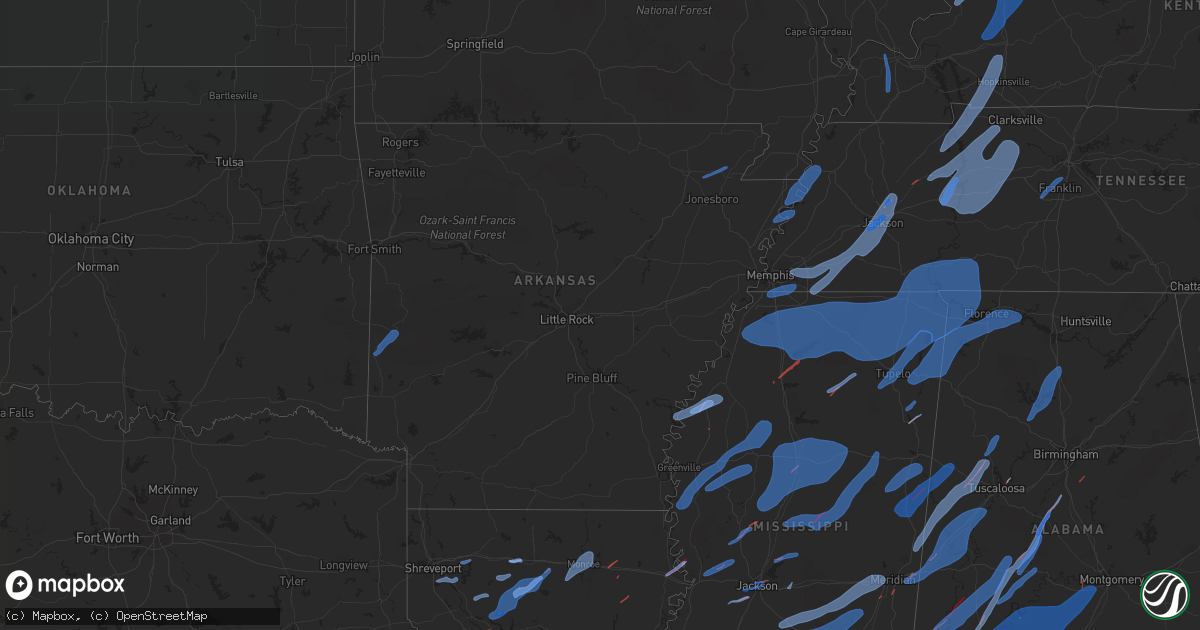
Hail Map in Arkansas on March 30, 2022
Get this storm
March 30 map
$229
one time, instant access
Download today. No call, no setup
Keep the $229
Bought the map and want the full workflow? Apply the entire $229 to a subscription within 7 days. None of it is wasted.
Every map, not just this one
This buys you this map. Subscription and you get every map we run, in the markets you choose from a few cities to whole states to nationwide. Plus real-time alerts the moment a storm fires.
Contact data
Name, contact info, occupancy, even credit band for addresses in the footprint. You go from where it hit to who to call.
Become the source they trust
Unlimited branding weather history reports on demand. You already have the documented answer ready for the property owner, and you are the one who showed up with it.
Property data and RoofTrace estimates
Pull up any address you have got, its value and the exact code rules for that jurisdiction, straight from One Click Code. Then RoofTrace estimates the squares, pitch, and roof value, priced the way you price.
Storm reports in Arkansas
Arkansas
| Date | Description |
|---|---|
| 03/30/20224:00 PM CDT | Overturned center pivot on 946 rd. |
| 03/30/20223:53 PM CDT | Damage to home with siding off home in marie. |
| 03/30/20223:45 PM CDT | Telephone pole down near s&l irrigation. |
| 03/30/20223:38 PM CDT | Semi blown off the road on i-55 at the 58 mile marker. |
| 03/30/20223:30 PM CDT | Several broken utility poles on chestnut st in marianna. |
| 03/30/20223:15 PM CDT | Roof blown off the lepanto museum. |
| 03/30/20223:05 PM CDT | Corrects previous tstm wnd dmg report from 6 se marmaduke. Overturned center pivot on 946 rd. |
| 03/30/20223:00 PM CDT | Roof torn off a mobile home. |
| 03/30/20223:00 PM CDT | Corrects previous tstm wnd dmg report from dyess. Roof torn off a mobile home along with tree damage in dyess... A pivot flipped over... And siding off the side of the |
| 03/30/20222:50 PM CDT | Large tree branch down. |
| 03/30/20222:45 PM CDT | Corrects previous tstm wnd dmg report from 1 n corning. Telephone pole down near s&l irrigation. |
| 03/30/20222:31 PM CDT | Recorded by a private weather station. |
| 03/30/20227:53 AM CDT | Numerous trees blown down...along with an old chicken house damaged. |
| 03/30/20227:46 AM CDT | A survey team from the nws in little rock found damage consistent with an ef1 tornado near harmony in johnson county. More information will be forthcoming once the team |
| 03/30/20227:38 AM CDT | Tree blown down on us hwy 71 north of mena. |
| 03/30/20227:36 AM CDT | A tree fell onto a mobile home. |
| 03/30/20224:58 AM CDT | At 957 AM CDT, a severe thunderstorm was located near Gainesville, or 23 miles north of Mountain Home, moving northeast at 60 mph. HAZARD...60 mph wind gusts. SOURCE...Radar indicated. IMPACT...Expect damage to roofs, siding, and trees. Locations impacted include... Gainesville... Hardenville... Brixey... Sycamore... Tecumseh... Dora... Rockbridge... Zanoni... |
| 03/30/20224:28 AM CDT | At 927 AM CDT, severe thunderstorms were located along a line extending from near Point Peter to Witts Spring to near Solo, moving northeast at 60 mph. HAZARD...60 mph wind gusts. SOURCE...Radar indicated. IMPACT...Expect damage to roofs, siding, and trees. Locations impacted include... Marshall... Norfork... Salesville... Briarcliff... Marsena... Witts Spring... Rocky Hill... Duff... Dabney... Point Peter... Herron... Maumee... Advance... Cartney... Bohannon... Imo... Culp... Elberta... Watts... Blanchard Springs Campground... |
| 03/30/20223:42 AM CDT | At 841 AM CDT, severe thunderstorms were located along a line extending from 8 miles north of Danville to 10 miles southeast of Fourche Valley, moving northeast at 55 mph. HAZARD...60 mph wind gusts. SOURCE...Radar indicated. IMPACT...Expect damage to roofs, siding, and trees. Locations impacted include... Russellville... Danville... Dardanelle... Atkins... Pottsville... Ola... Adona... Lake Dardanelle State Park... Petit Jean River WMA... Mosley... Carden Bottoms... Mt Nebo State Park... Petit Jean State Park... Plainview in Yell County... Galla Creek WMA... Lake Dardanelle... Belleville... Casa... Aplin... Corinth...This includes Interstate 40 between mile markers 81 and 93. |
| 03/30/20223:39 AM CDT | At 838 AM CDT, severe thunderstorms were located along a line extending from near Walnut to near Dillen to Holman, moving northeast at 55 mph. HAZARD...60 mph wind gusts. SOURCE...Radar indicated. IMPACT...Expect damage to roofs, siding, and trees. Locations impacted include... Marshall... Marsena... Witts Spring... Rocky Hill... Duff... Moore... Dabney... Point Peter... Maumee... Bohannon... Imo... Watts... Holman... Kay... Dillen... Solo... Smyrna... Rush... Eula... Woolum... |
| 03/30/20223:28 AM CDT | At 827 AM CDT, severe thunderstorms were located along a line extending from near Hartman to near Subiaco to near Mount Magazine, moving northeast at 55 mph. HAZARD...60 mph wind gusts. SOURCE...Radar indicated. IMPACT...Expect damage to roofs, siding, and trees. Locations impacted include... Russellville... Clarksville... Paris... Lamar... Dover... London... Knoxville... Subiaco... Hartman... Scranton... Blue Mountain... Devils Knob... Hoyt... Midway in Logan County... Taral... Holman... Rosetta... Dillen... Woodland... Hinkle...This includes Interstate 40 between mile markers 44 and 80. |
| 03/30/20223:01 AM CDT | At 800 AM CDT, severe thunderstorms were located along a line extending from near Cardiff to near Opal, moving northeast at 55 mph. HAZARD...60 mph wind gusts and quarter size hail. SOURCE...Radar indicated. IMPACT...Hail damage to vehicles is expected. Expect wind damage to roofs, siding, and trees. Locations impacted include... Mount Ida... Glenwood... Norman... Oden... Blue Mountain... Cardiff... Little Missouri Falls Recreatio... Bard Springs Recreation Area... Mauldin... Albert Pike Recreation Area... Muddy Creek WMA... Stonehouse Recreation Area... Opal... Mimosa... Gravelly... Fourche Valley... Mount Magazine... Belleville... Havana... Black Springs... |
| 03/30/20222:57 AM CDT | At 757 AM CDT, severe thunderstorms were located along a line extending from 6 miles west of Walnut to near Devils Knob to 6 miles northeast of Woodland to Clarksville, moving northeast at 50 mph. HAZARD...60 mph wind gusts and quarter size hail. SOURCE...Radar indicated. IMPACT...Hail damage to vehicles is expected. Expect wind damage to roofs, siding, and trees. Locations impacted include... Clarksville... Jasper... Dillen... Carver... Woodland... Moore... Devils Knob... Eula... Piercetown... Walnut... Bertha... Rosetta... Upper Buffalo Wilderness Area... Ben Hur... Bass... Catalpa... Fort Douglas... Fallsville... Crossroad... Swain...This includes Interstate 40 between mile markers 53 and 58. |
| 03/30/20222:44 AM CDT | At 743 AM CDT, severe thunderstorms were located along a line extending from near Fort Chaffee to Booneville to 7 miles north of Cardiff to near Waldron, moving northeast at 45 mph. HAZARD...60 mph wind gusts and quarter size hail. SOURCE...Radar indicated. IMPACT...Hail damage to vehicles is expected. Expect wind damage to roofs, siding, and trees. Locations impacted include... Clarksville... Booneville... Paris... Lamar... Magazine... Knoxville... Subiaco... Hartman... Scranton... Ratcliff... Blue Mountain... Hinkle... Hoyt... Mount Magazine... Midway in Logan County... Spadra... Tokalon... Coal Hill... Caulksville... Morrison Bluff...This includes Interstate 40 between mile markers 63 and 64. |
| 03/30/20222:26 AM CDT | At 726 AM CDT, a severe thunderstorm was located over Denning, or near Ozark, moving northeast at 50 mph. HAZARD...60 mph wind gusts and quarter size hail. SOURCE...Radar indicated. IMPACT...Hail damage to vehicles is expected. Expect wind damage to roofs, siding, and trees. Locations impacted include... Clarksville... Subiaco... Hartman... Scranton... Woodland... Hinkle... Devils Knob... Hoyt... Spadra... Rosetta... Coal Hill... Morrison Bluff... Oak Grove in Johnson County... Catalpa... Roseville... Fort Douglas... Yale... Fallsville... Haw Creek Falls Campground... Union City...This includes Interstate 40 between mile markers 45 and 59. |
| 03/30/20222:05 AM CDT | At 704 AM CDT, severe thunderstorms were located along a line extending from 6 miles north of Charleston to 3 miles southeast of Washburn, moving northeast at 55 mph. HAZARD...60 mph wind gusts. SOURCE...Radar indicated. IMPACT...Expect damage to roofs, siding, and trees. Locations in or near the path include... Ozark... Charleston... Mulberry... Altus... Branch... Denning... Wiederkehr Village... Fort Chaffee... Etna... Alix... Watalula... Meg... Toney... Peter Pender... Vesta... Cecil... Lonelm... Taft... Cravens... This includes Interstate 40 in Arkansas between mile markers 25 and42. |
| 03/30/20221:53 AM CDT | At 653 AM CDT, severe thunderstorms were located along a line extending from Echo to 8 miles south of Washburn to near Mansfield, moving northeast at 55 mph. HAZARD...70 mph wind gusts and quarter size hail. SOURCE...Radar indicated. IMPACT...Hail damage to vehicles is expected. Expect considerable tree damage. Wind damage is also likely to mobile homes, roofs, and outbuildings. Locations impacted include... Booneville... Waldron... Paris... Mansfield... Magazine... Ratcliff... Cardiff... Echo... Oliver... Caulksville... Barber... Winfield... Olio... Hon... Lucas... Chismville... Carbon City... Sugar Grove... Driggs... Carolan... |
| 03/30/20221:27 AM CDT | At 627 AM CDT, a severe thunderstorm was located over Octavia, moving northeast at 55 mph. HAZARD...60 mph wind gusts. SOURCE...Radar indicated. IMPACT...Expect damage to roofs, siding, and trees. Locations in or near the path include... Octavia... Muse... Big Cedar... |
| 03/30/202212:41 AM CDT | At 541 AM CDT, a severe thunderstorm was located 7 miles east of Cloudy, moving northeast at 65 mph. HAZARD...60 mph wind gusts. SOURCE...Radar indicated. IMPACT...Expect damage to roofs, siding, and trees. Locations in or near the path include... Whitesboro... Octavia... Muse... Big Cedar... Nashoba... Honobia... |
| 03/30/202212:38 AM CDT | At 537 AM CDT, severe thunderstorms were located along a line extending from near Oleta to near Cloudy to near Fort Towson to near Raymond Gary State Park, moving northeast at 65 mph. HAZARD...60 mph wind gusts and penny size hail. SOURCE...Radar indicated. IMPACT...Expect damage to roofs, siding, and trees. Locations impacted include... Wright City, Valliant, Plunketville, Rufe, Smithville, Hochatown, Watson, Battiest, Pickens, Mount Herman, Sherwood, Glover, Slim, Bethel and Ringold. |
| 03/30/202212:30 AM CDT | At 530 AM CDT, severe thunderstorms were located along a line extending from 6 miles northeast of Bokoshe to 5 miles south of Fanshawe, moving northeast at 30 mph. HAZARD...60 mph wind gusts. SOURCE...Radar indicated. IMPACT...Expect damage to roofs, siding, and trees. Locations in or near the path include... Poteau... Pocola... Muldrow... Roland... Spiro... Arkoma... Panama... Wister... Howe... Bokoshe... Fanshawe... Gans... Cameron... Moffett... Lake Wister State Park... Shady Point... Rock Island... Cowlington... Scullyville... Summerfield...This includes Interstate 40 in Oklahoma between mile markers 314 and328. |
| 03/29/202211:17 PM CDT | At 416 PM CDT, a severe thunderstorm was located over Dixonville, or 8 miles northwest of Millington, moving east at 30 mph. HAZARD...60 mph wind gusts. SOURCE...Radar indicated. IMPACT...Expect damage to roofs, siding, and trees. Locations impacted include... Millington, Covington, Wilson, Meeman Shelby Forest State Park, Munford, Brighton, Dixonville, Tipton, Atoka, Gilt Edge, Burlison, Garland, Barretville, Egypt, Griffin Corner, Quito, Golden Lake, Redwood, Rosemark and Idaville. |
| 03/29/202210:26 PM CDT | At 326 PM CDT, severe thunderstorms were located along a line extending from near Elaine to 6 miles south of Sherard to Mound Bayou, moving northeast at 55 mph. HAZARD...60 mph wind gusts. SOURCE...Radar indicated. IMPACT...Expect damage to roofs, siding, and trees. Locations impacted include... Clarksdale, Elaine, Helena-West Helena, St Francis National Park, Marks, Lambert, Jonestown, Friars Point, Tunica, Sledge, Belen, Dublin, Dubbs, North Tunica, Dundee, Darling, Kings, Sherard, Lake View and Coahoma. |
| 03/29/202210:06 PM CDT | At 306 PM CDT, a severe thunderstorm was located over Moro, or 10 miles west of Marianna, moving northeast at 60 mph. HAZARD...60 mph wind gusts. SOURCE...Radar indicated. IMPACT...Expect damage to roofs, siding, and trees. Locations impacted include... Forrest City, Marianna, Hughes, Marvell, Madison, Palestine, Caldwell, Colt, Lexa, Widener, Moro, Rondo, Aubrey, Haynes, Garret Grove, Brickeys, Watkins Corner, New Salem, New Home and Lake View. |
| 03/29/202210:03 PM CDT | At 302 AM CDT, severe thunderstorms were located along a line extending from 2 miles east of Cleora to 4 miles northwest of Jay to 5 miles southeast of Chloeta, moving northeast at 50 mph. HAZARD...60 mph wind gusts. SOURCE...Radar indicated. IMPACT...Expect damage to roofs, siding, and trees. Locations in or near the path include... Jay... Grove... Fairland... Afton... Bernice... Wyandotte... Cleora... Chloeta... Honey Creek State Park... Bernice State Park... Zena... Twin Bridges State Park... |
| 03/29/20229:56 PM CDT | At 255 PM CDT, a severe thunderstorm was located near Palmer, or 10 miles northwest of Marvell, moving northeast at 55 mph. HAZARD...60 mph wind gusts and penny size hail. SOURCE...Radar indicated. IMPACT...Expect damage to roofs, siding, and trees. Locations impacted include... Holly Grove... Palmer... Blackton... Pine City... Monroe... Ragtown... Louisiana Purchase State Park... |
| 03/29/20229:55 PM CDT | At 255 PM CDT, severe thunderstorms were located along a line extending from 6 miles east of Neelyville to near Oak Grove Heights, moving east at 45 mph. HAZARD...60 mph wind gusts. SOURCE...Radar indicated. IMPACT...Expect damage to roofs, siding, and trees. Locations impacted include... Paragould, Kennett, Malden, Piggott, Hayti, Steele, Campbell, Rector, Senath, Marmaduke, Chalk Bluff Natural Area, Clarkton, Oak Grove Heights, Cardwell, Holcomb, Hayti Heights, Arbyrd, Lafe, Wardell and St. Francis. |
| 03/29/20229:31 PM CDT | At 230 PM CDT, severe thunderstorms were located along a line extending from 7 miles southwest of Merrisach Lake to 6 miles north of Mcmillan Corner to near Millikin, moving northeast at 65 mph. HAZARD...60 mph wind gusts. SOURCE...Radar indicated. IMPACT...Expect damage to roofs, siding, and trees. Severe thunderstorms will be near... Scott around 245 PM CDT. Benoit around 250 PM CDT. Greenville, Leland, Metcalfe and Gunnison around 305 PM CDT. Shelby around 310 PM CDT. Deeson around 315 PM CDT. Shaw around 320 PM CDT. Cleveland, Renova and Boyle around 330 PM CDT.Other locations impacted by these severe thunderstorms includeAlligator, Winstonville, Beulah, Duncan, Pace and Merigold. |
| 03/29/20229:28 PM CDT | At 228 PM CDT, severe thunderstorms were located along a line extending from near Oxly to near Walcott, moving northeast at 60 mph. HAZARD...60 mph wind gusts. SOURCE...Radar indicated. IMPACT...Expect damage to roofs, siding, and trees. Locations impacted include... Paragould, Piggott, Corning, Campbell, Rector, Marmaduke, Chalk Bluff Natural Area, Crowleys Ridge State Park, Oak Grove Heights, Lafe, Reyno, Knobel, St. Francis, Pollard, Greenway, O'Kean, McDougal, Success, Peach Orchard and Delaplaine. |
| 03/29/20229:13 PM CDT | At 212 PM CDT, a severe thunderstorm was located near Weiner, or 14 miles northwest of Harrisburg, moving northeast at 40 mph. HAZARD...60 mph wind gusts. SOURCE...Radar indicated. IMPACT...Expect damage to roofs, siding, and trees. Locations impacted include... Jonesboro, Trumann, Bay, Brookland, Weiner, Greenfield, Pitts, Hergett, Needham, Apt, Lunsford, Valley View, Davis Spur, Elm Grove, Gum Point, Farrville, Gilkerson, Uno, Otwell and Cary. |
All States Impacted by Hail Map on March 30, 2022
Cities Impacted by Hail Map on March 30, 2022
- Milton, FL
- Cantonment, FL
- Diamondhead, MS
- Port Allen, LA
- Baton Rouge, LA
- Defuniak Springs, FL
- Panama City Beach, FL
- Panama City, FL
- Inlet Beach, FL
- Santa Rosa Beach, FL
- Summerdale, AL
- Vredenburgh, AL
- Franklin, AL
- Peterman, AL
- Beatrice, AL
- Pass Christian, MS
- Bagdad, FL
- Robertsdale, AL
- Holt, FL
- Pensacola, FL
- Elberta, AL
- Lillian, AL
- Seminole, AL
- Eglin Afb, FL
- Whatley, AL
- Jackson, AL
- Grove Hill, AL
- Gainestown, AL
- Theriot, LA
- Freeport, FL
- Ponce De Leon, FL
- Foley, AL
- Pine Apple, AL
- Leakesville, MS
- Niceville, FL
- Westville, FL
- Valparaiso, FL
- Crestview, FL
- Moss Point, MS
- Citronelle, AL
- Deer Park, AL
- Zachary, LA
- Holden, LA
- Greenwell Springs, LA
- Pride, LA
- Amite, LA
- Pine Grove, LA
- Walker, LA
- Denham Springs, LA
- Baker, LA
- Fairhope, AL
- Vancleave, MS
- Gulf Breeze, FL
- Coden, AL
- Bayou La Batre, AL
- Daphne, AL
- Theodore, AL
- Irvington, AL
- Long Beach, MS
- Gulfport, MS
- Waveland, MS
- Kiln, MS
- Pearlington, MS
- Bay Saint Louis, MS
- Slidell, LA
- New Orleans, LA
- Lucedale, MS
- McIntosh, AL
- Sunflower, AL
- Tibbie, AL
- Wagarville, AL
- Vinegar Bend, AL
- Echola, AL
- Eutaw, AL
- Berry, AL
- Aliceville, AL
- Porterville, MS
- Coker, AL
- Northport, AL
- Buhl, AL
- Elrod, AL
- Scooba, MS
- Carrollton, AL
- Gordo, AL
- Emelle, AL
- Epes, AL
- Cuba, AL
- Meridian, MS
- Forkland, AL
- Boligee, AL
- Akron, AL
- Livingston, AL
- Knoxville, AL
- Gainesville, AL
- Moundville, AL
- Toomsuba, MS
- York, AL
- Fosters, AL
- Lawley, AL
- Selma, AL
- Uniontown, AL
- Thomasville, AL
- Randolph, AL
- Marion, AL
- Thomaston, AL
- Marion Junction, AL
- Centreville, AL
- Montevallo, AL
- Brierfield, AL
- Safford, AL
- Catherine, AL
- Arlington, AL
- Pine Hill, AL
- Reform, AL
- Ethelsville, AL
- Shuqualak, MS
- Brooksville, MS
- Macon, MS
- Dennis, MS
- Mantachie, MS
- Tremont, MS
- Vina, AL
- Russellville, AL
- Cherokee, AL
- Muscle Shoals, AL
- Golden, MS
- Belmont, MS
- Town Creek, AL
- Courtland, AL
- Tuscumbia, AL
- Rogersville, AL
- Hillsboro, AL
- Red Bay, AL
- Sheffield, AL
- Fulton, MS
- Killen, AL
- Leighton, AL
- Nettleton, MS
- Dixons Mills, AL
- Campbell, AL
- Faunsdale, AL
- Coffeeville, AL
- Butler, AL
- Buckatunna, MS
- Gilbertown, AL
- Richton, MS
- Toxey, AL
- Magnolia, AL
- Millry, AL
- Waynesboro, MS
- Linden, AL
- Sweet Water, AL
- Newbern, AL
- Silas, AL
- Laurel, MS
- Bremen, AL
- Arley, AL
- Logan, AL
- Falkville, AL
- Cullman, AL
- Jasper, AL
- Vinemont, AL
- Crane Hill, AL
- Alberta, AL
- Orrville, AL
- Wilmer, AL
- Creola, AL
- Semmes, AL
- Eight Mile, AL
- Satsuma, AL
- Mobile, AL
- Bay Minette, AL
- Saraland, AL
- Perdido, AL
- Pascagoula, MS
- Stapleton, AL
- Loxley, AL
- Ocean Springs, MS
- Grand Bay, AL
- Gautier, MS
- Elm Grove, LA
- Shreveport, LA
- Bossier City, LA
- Doyline, LA
- Minden, LA
- Castor, LA
- Ringgold, LA
- Coushatta, LA
- Hall Summit, LA
- Burkeville, TX
- Anacoco, LA
- Florien, LA
- Hornbeck, LA
- Bienville, LA
- Jonesboro, LA
- Ruston, LA
- Choudrant, LA
- Saline, LA
- Quitman, LA
- Chatham, LA
- Eros, LA
- Goldonna, LA
- Simsboro, LA
- Arcadia, LA
- Leesville, LA
- Sieper, LA
- Elmer, LA
- Otis, LA
- Boyce, LA
- West Monroe, LA
- Monroe, LA
- Iowa, LA
- Bell City, LA
- Welsh, LA
- Cheneyville, LA
- Tallulah, LA
- Vicksburg, MS
- Church Point, LA
- Crowley, LA
- Sunset, LA
- Branch, LA
- Rayne, LA
- Iota, LA
- Covington, LA
- Folsom, LA
- Carriere, MS
- Albany, LA
- Springfield, LA
- Poplarville, MS
- Livingston, LA
- Bush, LA
- Hammond, LA
- Ponchatoula, LA
- Picayune, MS
- Franklinton, LA
- Bogalusa, LA
- Tickfaw, LA
- Loranger, LA
- Robert, LA
- Abita Springs, LA
- Roseland, LA
- Columbia, MS
- Mount Hermon, LA
- Purvis, MS
- Hattiesburg, MS
- Independence, LA
- Angie, LA
- Kentwood, LA
- Lumberton, MS
- Tylertown, MS
- Sandy Hook, MS
- Many, LA
- Oakfield, TN
- Mercer, TN
- Lavinia, TN
- Jackson, TN
- Denmark, TN
- Toone, TN
- Moscow, TN
- Arlington, TN
- Milan, TN
- Eads, TN
- Somerville, TN
- Whiteville, TN
- Holly Springs, MS
- Williston, TN
- Rossville, TN
- Cordova, TN
- Medina, TN
- Collierville, TN
- Humboldt, TN
- Oakland, TN
- Byhalia, MS
- Bolivar, TN
- Medon, TN
- Olive Branch, MS
- Memphis, TN
- Germantown, TN
- Horn Lake, MS
- Southaven, MS
- Walls, MS
- Gracey, KY
- Fort Campbell, KY
- Cadiz, KY
- Bumpus Mills, TN
- Cerulean, KY
- Hopkinsville, KY
- Springville, TN
- Herndon, KY
- Crofton, KY
- Stewart, TN
- Paris, TN
- La Fayette, KY
- Big Sandy, TN
- Dover, TN
- Big Rock, TN
- Linden, TN
- Eva, TN
- Waverly, TN
- Sugar Tree, TN
- Holladay, TN
- Lobelville, TN
- Hollow Rock, TN
- New Johnsonville, TN
- Woodlawn, TN
- Cunningham, TN
- Parsons, TN
- Erin, TN
- Vanleer, TN
- Dickson, TN
- Palmyra, TN
- Bruceton, TN
- McEwen, TN
- Nunnelly, TN
- Buena Vista, TN
- Only, TN
- Cumberland City, TN
- Hurricane Mills, TN
- Indian Mound, TN
- Centerville, TN
- Cumberland Furnace, TN
- Tennessee Ridge, TN
- Camden, TN
- Charlotte, TN
- Thompsons Station, TN
- Brentwood, TN
- Franklin, TN
- Minter City, MS
- Itta Bena, MS
- Holcomb, MS
- Greenwood, MS
- Leland, MS
- Charleston, MS
- Philipp, MS
- Chatham, MS
- Sunflower, MS
- Glen Allan, MS
- Inverness, MS
- Schlater, MS
- Hollandale, MS
- Moorhead, MS
- Indianola, MS
- Greenville, MS
- Belzoni, MS
- Sidon, MS
- Isola, MS
- Duncan, MS
- Rosedale, MS
- Mound Bayou, MS
- Tutwiler, MS
- Watson, AR
- Shelby, MS
- Clarksdale, MS
- Gunnison, MS
- Bolton, MS
- Flora, MS
- Bentonia, MS
- Yazoo City, MS
- Benton, MS
- Byram, MS
- Raymond, MS
- Utica, MS
- Terry, MS
- West, MS
- French Camp, MS
- Kilmichael, MS
- Coila, MS
- Durant, MS
- Eupora, MS
- Walthall, MS
- Duck Hill, MS
- Vaiden, MS
- Stewart, MS
- Cruger, MS
- Ackerman, MS
- Ethel, MS
- Winona, MS
- Lexington, MS
- Mathiston, MS
- McCarley, MS
- North Carrollton, MS
- Weir, MS
- Carrollton, MS
- Jackson, MS
- Flowood, MS
- Pearl, MS
- Lena, MS
- Canton, MS
- Brandon, MS
- Stantonville, TN
- Tupelo, MS
- Crump, TN
- Olivehill, TN
- Crenshaw, MS
- Hickory Flat, MS
- Glen, MS
- Thaxton, MS
- Batesville, MS
- Abbeville, MS
- Iuka, MS
- Iron City, TN
- Ecru, MS
- Sardis, MS
- Adamsville, TN
- Burnsville, MS
- Myrtle, MS
- Lutts, TN
- Lamar, MS
- Dundee, MS
- Hernando, MS
- Michigan City, MS
- Ripley, MS
- Selmer, TN
- Shiloh, TN
- Etta, MS
- Blue Springs, MS
- Blue Mountain, MS
- Cypress Inn, TN
- Falkner, MS
- Tiplersville, MS
- Savannah, TN
- Dumas, MS
- Counce, TN
- Senatobia, MS
- Waynesboro, TN
- Baldwyn, MS
- Rienzi, MS
- Florence, AL
- Michie, TN
- Como, MS
- Potts Camp, MS
- Waterford, MS
- Red Banks, MS
- Saltillo, MS
- Coldwater, MS
- Booneville, MS
- Ashland, MS
- Marietta, MS
- Oxford, MS
- Guys, TN
- Sarah, MS
- Waterloo, AL
- Tunica, MS
- Tishomingo, MS
- Ramer, TN
- New Albany, MS
- Collinwood, TN
- Corinth, MS
- Walnut, MS
- Guntown, MS
- McCool, MS
- Sallis, MS
- Carthage, MS
- Starkville, MS
- Kosciusko, MS
- Goodman, MS
- Noxapater, MS
- Philadelphia, MS
- Camden, MS
- Louisville, MS
- Sturgis, MS
- Bruce, MS
- Banner, MS
- Pontotoc, MS
- Randolph, MS
- Mccomb, MS
- Collins, MS
- Taylorsville, MS
- Monticello, MS
- Mendenhall, MS
- Rose Hill, MS
- Bay Springs, MS
- Louin, MS
- Pinola, MS
- Mize, MS
- Oak Vale, MS
- Ruth, MS
- Smithdale, MS
- Soso, MS
- Prentiss, MS
- Mount Olive, MS
- Summit, MS
- Liberty, MS
- Newhebron, MS
- Stringer, MS
- Magee, MS
- Paulding, MS
- Magnolia, MS
- Silver Creek, MS
- Jayess, MS
- Shannon, MS
- Verona, MS
- Mooreville, MS
- Plantersville, MS
- New Site, MS
- Hickory, MS
- Chunky, MS
- Raleigh, MS
- Lawrence, MS
- Enterprise, MS
- Forest, MS
- Newton, MS
- Braxton, MS
- Aberdeen, MS
- Crawford, MS
- Columbus, MS
- Amory, MS
- Brooklyn, MS
- Wiggins, MS
- Petal, MS
- New Augusta, MS
- Fort Deposit, AL
- Lower Peach Tree, AL
- Hayneville, AL
- Minter, AL
- Monroeville, AL
- Letohatchee, AL
- Leroy, AL
- Coy, AL
- Beaumont, MS
- McLain, MS
- Saint Stephens, AL
- Hope Hull, AL
- Fruitdale, AL
- Lowndesboro, AL
- Camden, AL
- Greenville, AL
- Little River, AL
- Frisco City, AL
- Prattville, AL
- Uriah, AL
- Montgomery, AL
- Tyler, AL
- State Line, MS
- Neely, MS
- Dickinson, AL
- Forest Home, AL
- Perkinston, MS
- Rayville, LA
- Lacombe, LA
- Cottondale, AL
- Tuscaloosa, AL
- Columbiana, AL
- Chipley, FL
- Alford, FL
- Cottondale, FL
- Hemphill, TX
- Natchitoches, LA
- Campti, LA
- Winnsboro, LA
- Cleveland, MS
- Courtland, MS
- Pope, MS
- Enid, MS
- Huntingdon, TN
- Thompsonville, IL
- Macedonia, IL
- Carmi, IL
- Evansville, IN
- Fairfield, IL
- Crossville, IL
- Norris City, IL
- Cove, AR
- Hatfield, AR
- Mena, AR
- Paragould, AR
- Bono, AR
- Ripley, TN
- Luxora, AR
- Finley, TN
- Dyersburg, TN
- Lenox, TN
- Halls, TN
- Blytheville, AR
- Henning, TN
- Osceola, AR
- Baker, FL
- Laurel Hill, FL
- Marianna, FL
- Wewahitchka, FL
- Port Saint Joe, FL
- Kevil, KY
- West Paducah, KY
- Paducah, KY
- Boaz, KY
- Hickory, KY
- Fancy Farm, KY
- Melber, KY
- Mayfield, KY
- Uniontown, KY
- Corydon, KY
- Waverly, KY
- Henderson, KY
- Morganfield, KY
- Sturgis, KY
- Owensboro, KY
- Calhoun, KY
- Madisonville, KY
- Sebree, KY
- Rockport, IN
- Hanson, KY
- Slaughters, KY
- Nebo, KY
- Rumsey, KY
- Manitou, KY
- Utica, KY
- Dawson Springs, KY
- Robards, KY
- Richland, IN


