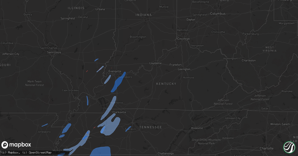
Hail Map in Kentucky on March 30, 2022
Get this storm
March 30 map
$229
one time, instant access
Download today. No call, no setup
Keep the $229
Bought the map and want the full workflow? Apply the entire $229 to a subscription within 7 days. None of it is wasted.
Every map, not just this one
This buys you this map. Subscription and you get every map we run, in the markets you choose from a few cities to whole states to nationwide. Plus real-time alerts the moment a storm fires.
Contact data
Name, contact info, occupancy, even credit band for addresses in the footprint. You go from where it hit to who to call.
Become the source they trust
Unlimited branding weather history reports on demand. You already have the documented answer ready for the property owner, and you are the one who showed up with it.
Property data and RoofTrace estimates
Pull up any address you have got, its value and the exact code rules for that jurisdiction, straight from One Click Code. Then RoofTrace estimates the squares, pitch, and roof value, priced the way you price.
Storm reports in Kentucky
Kentucky
| Date | Description |
|---|---|
| 03/30/20226:52 PM CDT | Tree blocking road. |
| 03/30/20226:48 PM CDT | Large tree limbs down... High winds. |
| 03/30/20226:40 PM CDT | Mesonet station frny morganfield ky 4 e. |
| 03/30/20226:32 PM CDT | A local report indicates 75 MPH wind near 1 WNW GRACEY |
| 03/30/20226:20 PM CDT | Several trees down and a few power lines and a couple of power poles down. |
| 03/30/20226:12 PM CDT | Trees down on old salem road. |
| 03/30/20226:05 PM CDT | Corrects previous tstm wnd dmg report from 2 ne lynn grove. Trees down on thurman road. |
| 03/30/20226:05 PM CDT | Trees down on thurmond road. |
| 03/30/20225:55 PM CDT | Trees down on faxon road. |
| 03/30/20225:25 PM CDT | Approximately 975 customers without power in paducah. |
| 03/30/20225:10 PM CDT | Trees down in kevil. |
| 03/30/20225:10 PM CDT | Several trees down in the benton area. |
| 03/30/20225:10 PM CDT | Power pole down at intersection of mt. Mariah rd and us68 west. |
| 03/30/20224:59 PM CDT | A local report indicates 60 MPH wind near 2 SE HEATH |
| 03/30/20224:29 AM CDT | At 928 PM CDT, a severe thunderstorm was located over Old Hickory, or 10 miles northeast of Nashville, moving northeast at 70 mph. HAZARD...60 mph wind gusts. SOURCE...Radar indicated. IMPACT...Expect damage to roofs, siding, and trees. Locations impacted include... Gallatin, Madison, Hendersonville, Mount Juliet, Goodlettsville, White House, Millersville, Lakewood, Westmoreland, Portland, Hermitage, Old Hickory, Mitchellville, Green Hill, Bethpage, Oak Grove, Bledsoe Creek State Park, Cottontown and Percy Priest Lake.This includes the following highways... Interstate 40 between mile markers 215 and 225. Interstate 65 between mile markers 88 and 101. Interstate 24 between mile markers 42 and 44. |
| 03/30/20222:50 AM CDT | At 749 PM CDT, severe thunderstorms were located along a line extending from near Fort Campbell to 9 miles northeast of McEwen, moving northeast at 60 mph. HAZARD...60 mph wind gusts. SOURCE...Radar indicated. IMPACT...Expect damage to roofs, siding, and trees. Severe thunderstorms will be near... Oak Grove and Fort Campbell around 755 PM CDT. Pembroke around 805 PM CDT.Other locations in the path of these severe thunderstorms includeElkton, Clarksville and Guthrie.This includes the following highways... Interstate 24 in Kentucky between Mile Markers 81 and 92. Pennyrile Parkway between Mile Markers 1 and 2. |
| 03/30/20222:45 AM CDT | At 745 PM CDT, severe thunderstorms were located along a line extending from Big Rock to near McEwen, moving northeast at 55 mph. HAZARD...60 mph wind gusts. SOURCE...Radar indicated. IMPACT...Expect damage to roofs, siding, and trees. Locations impacted include... Clarksville, Vanleer, Slayden, Cheatham Dam, Palmyra, Cunningham and Woodlawn.This includes Interstate 24 between mile markers 1 and 16. |
| 03/30/20222:19 AM CDT | At 719 PM CDT, severe thunderstorms were located along a line extending from near Paris Landing State Park to near New Johnsonville, moving northeast at 70 mph. HAZARD...60 mph wind gusts. SOURCE...Radar indicated. IMPACT...Expect damage to roofs, siding, and trees. Locations impacted include... Waverly, Dover, Erin, New Johnsonville, McEwen, Tennessee Ridge, Big Rock, Cumberland City, Land Between The Lakes, Houston County Airport and Indian Mound. |
| 03/30/20222:09 AM CDT | At 708 PM CDT, a severe thunderstorm was located near Livermore, moving northeast at 85 mph. HAZARD...70 mph wind gusts. SOURCE...Radar indicated. IMPACT...Expect considerable tree damage. Damage is likely to mobile homes, roofs, and outbuildings. This severe thunderstorm will remain over mainly rural areas of southwestern Ohio County, including the following locations... Centertown, Nineteen, Scottown, Matanzas, Buford, No Creek, Heflin, Coffman, Mchenry and Rockport. |
| 03/30/20221:54 AM CDT | At 652 PM CDT, severe thunderstorms were located along a line extending from near Mount Carmel to near Morganfield, moving northeast at 35 mph. HAZARD...70 mph wind gusts. SOURCE...Trained weather spotters. Winds to 70 mph have been measured along this line. IMPACT...Expect considerable tree damage. Damage is likely to mobile homes, roofs, and outbuildings. Severe thunderstorms will be near... Owensville around 710 PM CDT.Other locations in the path of these severe thunderstorms includeFort Branch, Princeton, Patoka, Henderson, Oakland City, Newburgh,Winslow, Stanley, Petersburg, Boonville and Eureka.This includes the following highways... Interstate 69 in Kentucky between Mile Markers 141 and 148. Interstate 69 in Indiana between Mile Markers 1 and 52. Interstate 64 in Indiana between Mile Markers 18 and 60. Audubon Parkway between Mile Markers 1 and 14. |
| 03/30/20221:40 AM CDT | At 640 PM CDT, severe thunderstorms were located along a line extending from 6 miles west of Madisonville to near Crofton to near Hopkinsville, moving northeast at 85 mph. HAZARD...70 mph wind gusts. SOURCE...Trained weather spotters. IMPACT...Expect considerable tree damage. Damage is likely to mobile homes, roofs, and outbuildings. Severe thunderstorms will be near... Nortonville and Mortons Gap around 645 PM CDT. Madisonville and Earlington around 650 PM CDT. Beech Grove around 655 PM CDT. St. Joseph and Weir around 700 PM CDT.Other locations in the path of these severe thunderstorms includeCalhoun, Powderly, Graham, Greenville, Central City, Owensboro,Livermore and Masonville.This includes the following highways... Interstate 165 between Mile Markers 65 and 69. Interstate 69 in Kentucky between Mile Markers 94 and 135. Western Kentucky Parkway between Mile Markers 39 and 64. Pennyrile Parkway between Mile Markers 25 and 34. Audubon Parkway between Mile Markers 15 and 21. |
| 03/30/20221:00 AM CDT | At 600 PM CDT, a severe thunderstorm was located near Paris Landing State Park, moving northeast at 70 mph. HAZARD...60 mph wind gusts and penny size hail. SOURCE...Radar indicated. IMPACT...Expect damage to roofs, siding, and trees. Locations impacted include... Dover, Big Rock and Land Between The Lakes. |
| 03/30/202212:10 AM CDT | At 509 PM CDT, severe thunderstorms were located along a line extending from near West City to near Karnak, moving east at 30 mph. HAZARD...70 mph wind gusts. SOURCE...Radar indicated. IMPACT...Expect considerable tree damage. Damage is likely to mobile homes, roofs, and outbuildings. Locations impacted include... Marion, Mcleansboro, Benton, and Vienna.This includes the following highways... Interstate 24 in Illinois between Mile Markers 1 and 23. Interstate 57 in Illinois between Mile Markers 40 and 80. |
| 03/29/202211:15 PM CDT | Multiple trees down across the road and on property in muddy ford rd/double culvert rd area north of georgetown. Time estimated using peak winds at surrounding weather |
| 03/29/202210:39 PM CDT | At 339 PM CDT, severe thunderstorms were located along a line extending from near Risco to near Bolton to near Steele, moving northeast at 50 mph. HAZARD...60 mph wind gusts. SOURCE...Radar indicated. IMPACT...Expect damage to roofs, siding, and trees. Locations impacted include... Union City, Caruthersville, Portageville, Hayti, Steele, Reelfoot Lake State Park, Tiptonville, Newbern, Ridgely, Troy, Obion, Hayti Heights, Wardell, Clayton, Bolton, Cloverdale, Miston, Cottonwood Grove, Trimble and Hornbeak. |
| 03/29/202210:09 PM CDT | At 309 PM CDT, severe thunderstorms were located along a line extending from near Wappapello to Qulin to near Pollard, moving northeast at 45 to 50 mph. HAZARD...60 mph wind gusts. SOURCE...Radar indicated. IMPACT...Expect damage to roofs, siding, and trees. Severe thunderstorms will be near... Puxico around 320 PM CDT.Other locations in the path of these severe thunderstorms includeBernie, Dudley, Dexter, Malden, Bloomfield, Advance, Essex, BellCity, Risco, Parma, Sikeston and Morehouse.This includes Interstate 55 between Mile Markers 33 and 65. |
| 03/29/20228:04 PM CDT | Large tree limbs down. |
| 03/29/20227:15 PM CDT | 2100 customers without power in henderson county. |
| 03/29/20227:10 PM CDT | Tree down along hwy 56. |
All States Impacted by Hail Map on March 30, 2022
Cities Impacted by Hail Map on March 30, 2022
- Milton, FL
- Cantonment, FL
- Diamondhead, MS
- Port Allen, LA
- Baton Rouge, LA
- Defuniak Springs, FL
- Panama City Beach, FL
- Panama City, FL
- Inlet Beach, FL
- Santa Rosa Beach, FL
- Summerdale, AL
- Vredenburgh, AL
- Franklin, AL
- Peterman, AL
- Beatrice, AL
- Pass Christian, MS
- Bagdad, FL
- Robertsdale, AL
- Holt, FL
- Pensacola, FL
- Elberta, AL
- Lillian, AL
- Seminole, AL
- Eglin Afb, FL
- Whatley, AL
- Jackson, AL
- Grove Hill, AL
- Gainestown, AL
- Theriot, LA
- Freeport, FL
- Ponce De Leon, FL
- Foley, AL
- Pine Apple, AL
- Leakesville, MS
- Niceville, FL
- Westville, FL
- Valparaiso, FL
- Crestview, FL
- Moss Point, MS
- Citronelle, AL
- Deer Park, AL
- Zachary, LA
- Holden, LA
- Greenwell Springs, LA
- Pride, LA
- Amite, LA
- Pine Grove, LA
- Walker, LA
- Denham Springs, LA
- Baker, LA
- Fairhope, AL
- Vancleave, MS
- Gulf Breeze, FL
- Coden, AL
- Bayou La Batre, AL
- Daphne, AL
- Theodore, AL
- Irvington, AL
- Long Beach, MS
- Gulfport, MS
- Waveland, MS
- Kiln, MS
- Pearlington, MS
- Bay Saint Louis, MS
- Slidell, LA
- New Orleans, LA
- Lucedale, MS
- McIntosh, AL
- Sunflower, AL
- Tibbie, AL
- Wagarville, AL
- Vinegar Bend, AL
- Echola, AL
- Eutaw, AL
- Berry, AL
- Aliceville, AL
- Porterville, MS
- Coker, AL
- Northport, AL
- Buhl, AL
- Elrod, AL
- Scooba, MS
- Carrollton, AL
- Gordo, AL
- Emelle, AL
- Epes, AL
- Cuba, AL
- Meridian, MS
- Forkland, AL
- Boligee, AL
- Akron, AL
- Livingston, AL
- Knoxville, AL
- Gainesville, AL
- Moundville, AL
- Toomsuba, MS
- York, AL
- Fosters, AL
- Lawley, AL
- Selma, AL
- Uniontown, AL
- Thomasville, AL
- Randolph, AL
- Marion, AL
- Thomaston, AL
- Marion Junction, AL
- Centreville, AL
- Montevallo, AL
- Brierfield, AL
- Safford, AL
- Catherine, AL
- Arlington, AL
- Pine Hill, AL
- Reform, AL
- Ethelsville, AL
- Shuqualak, MS
- Brooksville, MS
- Macon, MS
- Dennis, MS
- Mantachie, MS
- Tremont, MS
- Vina, AL
- Russellville, AL
- Cherokee, AL
- Muscle Shoals, AL
- Golden, MS
- Belmont, MS
- Town Creek, AL
- Courtland, AL
- Tuscumbia, AL
- Rogersville, AL
- Hillsboro, AL
- Red Bay, AL
- Sheffield, AL
- Fulton, MS
- Killen, AL
- Leighton, AL
- Nettleton, MS
- Dixons Mills, AL
- Campbell, AL
- Faunsdale, AL
- Coffeeville, AL
- Butler, AL
- Buckatunna, MS
- Gilbertown, AL
- Richton, MS
- Toxey, AL
- Magnolia, AL
- Millry, AL
- Waynesboro, MS
- Linden, AL
- Sweet Water, AL
- Newbern, AL
- Silas, AL
- Laurel, MS
- Bremen, AL
- Arley, AL
- Logan, AL
- Falkville, AL
- Cullman, AL
- Jasper, AL
- Vinemont, AL
- Crane Hill, AL
- Alberta, AL
- Orrville, AL
- Wilmer, AL
- Creola, AL
- Semmes, AL
- Eight Mile, AL
- Satsuma, AL
- Mobile, AL
- Bay Minette, AL
- Saraland, AL
- Perdido, AL
- Pascagoula, MS
- Stapleton, AL
- Loxley, AL
- Ocean Springs, MS
- Grand Bay, AL
- Gautier, MS
- Elm Grove, LA
- Shreveport, LA
- Bossier City, LA
- Doyline, LA
- Minden, LA
- Castor, LA
- Ringgold, LA
- Coushatta, LA
- Hall Summit, LA
- Burkeville, TX
- Anacoco, LA
- Florien, LA
- Hornbeck, LA
- Bienville, LA
- Jonesboro, LA
- Ruston, LA
- Choudrant, LA
- Saline, LA
- Quitman, LA
- Chatham, LA
- Eros, LA
- Goldonna, LA
- Simsboro, LA
- Arcadia, LA
- Leesville, LA
- Sieper, LA
- Elmer, LA
- Otis, LA
- Boyce, LA
- West Monroe, LA
- Monroe, LA
- Iowa, LA
- Bell City, LA
- Welsh, LA
- Cheneyville, LA
- Tallulah, LA
- Vicksburg, MS
- Church Point, LA
- Crowley, LA
- Sunset, LA
- Branch, LA
- Rayne, LA
- Iota, LA
- Covington, LA
- Folsom, LA
- Carriere, MS
- Albany, LA
- Springfield, LA
- Poplarville, MS
- Livingston, LA
- Bush, LA
- Hammond, LA
- Ponchatoula, LA
- Picayune, MS
- Franklinton, LA
- Bogalusa, LA
- Tickfaw, LA
- Loranger, LA
- Robert, LA
- Abita Springs, LA
- Roseland, LA
- Columbia, MS
- Mount Hermon, LA
- Purvis, MS
- Hattiesburg, MS
- Independence, LA
- Angie, LA
- Kentwood, LA
- Lumberton, MS
- Tylertown, MS
- Sandy Hook, MS
- Many, LA
- Oakfield, TN
- Mercer, TN
- Lavinia, TN
- Jackson, TN
- Denmark, TN
- Toone, TN
- Moscow, TN
- Arlington, TN
- Milan, TN
- Eads, TN
- Somerville, TN
- Whiteville, TN
- Holly Springs, MS
- Williston, TN
- Rossville, TN
- Cordova, TN
- Medina, TN
- Collierville, TN
- Humboldt, TN
- Oakland, TN
- Byhalia, MS
- Bolivar, TN
- Medon, TN
- Olive Branch, MS
- Memphis, TN
- Germantown, TN
- Horn Lake, MS
- Southaven, MS
- Walls, MS
- Gracey, KY
- Fort Campbell, KY
- Cadiz, KY
- Bumpus Mills, TN
- Cerulean, KY
- Hopkinsville, KY
- Springville, TN
- Herndon, KY
- Crofton, KY
- Stewart, TN
- Paris, TN
- La Fayette, KY
- Big Sandy, TN
- Dover, TN
- Big Rock, TN
- Linden, TN
- Eva, TN
- Waverly, TN
- Sugar Tree, TN
- Holladay, TN
- Lobelville, TN
- Hollow Rock, TN
- New Johnsonville, TN
- Woodlawn, TN
- Cunningham, TN
- Parsons, TN
- Erin, TN
- Vanleer, TN
- Dickson, TN
- Palmyra, TN
- Bruceton, TN
- McEwen, TN
- Nunnelly, TN
- Buena Vista, TN
- Only, TN
- Cumberland City, TN
- Hurricane Mills, TN
- Indian Mound, TN
- Centerville, TN
- Cumberland Furnace, TN
- Tennessee Ridge, TN
- Camden, TN
- Charlotte, TN
- Thompsons Station, TN
- Brentwood, TN
- Franklin, TN
- Minter City, MS
- Itta Bena, MS
- Holcomb, MS
- Greenwood, MS
- Leland, MS
- Charleston, MS
- Philipp, MS
- Chatham, MS
- Sunflower, MS
- Glen Allan, MS
- Inverness, MS
- Schlater, MS
- Hollandale, MS
- Moorhead, MS
- Indianola, MS
- Greenville, MS
- Belzoni, MS
- Sidon, MS
- Isola, MS
- Duncan, MS
- Rosedale, MS
- Mound Bayou, MS
- Tutwiler, MS
- Watson, AR
- Shelby, MS
- Clarksdale, MS
- Gunnison, MS
- Bolton, MS
- Flora, MS
- Bentonia, MS
- Yazoo City, MS
- Benton, MS
- Byram, MS
- Raymond, MS
- Utica, MS
- Terry, MS
- West, MS
- French Camp, MS
- Kilmichael, MS
- Coila, MS
- Durant, MS
- Eupora, MS
- Walthall, MS
- Duck Hill, MS
- Vaiden, MS
- Stewart, MS
- Cruger, MS
- Ackerman, MS
- Ethel, MS
- Winona, MS
- Lexington, MS
- Mathiston, MS
- McCarley, MS
- North Carrollton, MS
- Weir, MS
- Carrollton, MS
- Jackson, MS
- Flowood, MS
- Pearl, MS
- Lena, MS
- Canton, MS
- Brandon, MS
- Stantonville, TN
- Tupelo, MS
- Crump, TN
- Olivehill, TN
- Crenshaw, MS
- Hickory Flat, MS
- Glen, MS
- Thaxton, MS
- Batesville, MS
- Abbeville, MS
- Iuka, MS
- Iron City, TN
- Ecru, MS
- Sardis, MS
- Adamsville, TN
- Burnsville, MS
- Myrtle, MS
- Lutts, TN
- Lamar, MS
- Dundee, MS
- Hernando, MS
- Michigan City, MS
- Ripley, MS
- Selmer, TN
- Shiloh, TN
- Etta, MS
- Blue Springs, MS
- Blue Mountain, MS
- Cypress Inn, TN
- Falkner, MS
- Tiplersville, MS
- Savannah, TN
- Dumas, MS
- Counce, TN
- Senatobia, MS
- Waynesboro, TN
- Baldwyn, MS
- Rienzi, MS
- Florence, AL
- Michie, TN
- Como, MS
- Potts Camp, MS
- Waterford, MS
- Red Banks, MS
- Saltillo, MS
- Coldwater, MS
- Booneville, MS
- Ashland, MS
- Marietta, MS
- Oxford, MS
- Guys, TN
- Sarah, MS
- Waterloo, AL
- Tunica, MS
- Tishomingo, MS
- Ramer, TN
- New Albany, MS
- Collinwood, TN
- Corinth, MS
- Walnut, MS
- Guntown, MS
- McCool, MS
- Sallis, MS
- Carthage, MS
- Starkville, MS
- Kosciusko, MS
- Goodman, MS
- Noxapater, MS
- Philadelphia, MS
- Camden, MS
- Louisville, MS
- Sturgis, MS
- Bruce, MS
- Banner, MS
- Pontotoc, MS
- Randolph, MS
- Mccomb, MS
- Collins, MS
- Taylorsville, MS
- Monticello, MS
- Mendenhall, MS
- Rose Hill, MS
- Bay Springs, MS
- Louin, MS
- Pinola, MS
- Mize, MS
- Oak Vale, MS
- Ruth, MS
- Smithdale, MS
- Soso, MS
- Prentiss, MS
- Mount Olive, MS
- Summit, MS
- Liberty, MS
- Newhebron, MS
- Stringer, MS
- Magee, MS
- Paulding, MS
- Magnolia, MS
- Silver Creek, MS
- Jayess, MS
- Shannon, MS
- Verona, MS
- Mooreville, MS
- Plantersville, MS
- New Site, MS
- Hickory, MS
- Chunky, MS
- Raleigh, MS
- Lawrence, MS
- Enterprise, MS
- Forest, MS
- Newton, MS
- Braxton, MS
- Aberdeen, MS
- Crawford, MS
- Columbus, MS
- Amory, MS
- Brooklyn, MS
- Wiggins, MS
- Petal, MS
- New Augusta, MS
- Fort Deposit, AL
- Lower Peach Tree, AL
- Hayneville, AL
- Minter, AL
- Monroeville, AL
- Letohatchee, AL
- Leroy, AL
- Coy, AL
- Beaumont, MS
- McLain, MS
- Saint Stephens, AL
- Hope Hull, AL
- Fruitdale, AL
- Lowndesboro, AL
- Camden, AL
- Greenville, AL
- Little River, AL
- Frisco City, AL
- Prattville, AL
- Uriah, AL
- Montgomery, AL
- Tyler, AL
- State Line, MS
- Neely, MS
- Dickinson, AL
- Forest Home, AL
- Perkinston, MS
- Rayville, LA
- Lacombe, LA
- Cottondale, AL
- Tuscaloosa, AL
- Columbiana, AL
- Chipley, FL
- Alford, FL
- Cottondale, FL
- Hemphill, TX
- Natchitoches, LA
- Campti, LA
- Winnsboro, LA
- Cleveland, MS
- Courtland, MS
- Pope, MS
- Enid, MS
- Huntingdon, TN
- Thompsonville, IL
- Macedonia, IL
- Carmi, IL
- Evansville, IN
- Fairfield, IL
- Crossville, IL
- Norris City, IL
- Cove, AR
- Hatfield, AR
- Mena, AR
- Paragould, AR
- Bono, AR
- Ripley, TN
- Luxora, AR
- Finley, TN
- Dyersburg, TN
- Lenox, TN
- Halls, TN
- Blytheville, AR
- Henning, TN
- Osceola, AR
- Baker, FL
- Laurel Hill, FL
- Marianna, FL
- Wewahitchka, FL
- Port Saint Joe, FL
- Kevil, KY
- West Paducah, KY
- Paducah, KY
- Boaz, KY
- Hickory, KY
- Fancy Farm, KY
- Melber, KY
- Mayfield, KY
- Uniontown, KY
- Corydon, KY
- Waverly, KY
- Henderson, KY
- Morganfield, KY
- Sturgis, KY
- Owensboro, KY
- Calhoun, KY
- Madisonville, KY
- Sebree, KY
- Rockport, IN
- Hanson, KY
- Slaughters, KY
- Nebo, KY
- Rumsey, KY
- Manitou, KY
- Utica, KY
- Dawson Springs, KY
- Robards, KY
- Richland, IN


