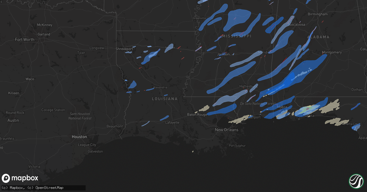
Hail Map in Louisiana on March 30, 2022
Get this storm
March 30 map
$229
one time, instant access
Download today. No call, no setup
Keep the $229
Bought the map and want the full workflow? Apply the entire $229 to a subscription within 7 days. None of it is wasted.
Every map, not just this one
This buys you this map. Subscription and you get every map we run, in the markets you choose from a few cities to whole states to nationwide. Plus real-time alerts the moment a storm fires.
Contact data
Name, contact info, occupancy, even credit band for addresses in the footprint. You go from where it hit to who to call.
Become the source they trust
Unlimited branding weather history reports on demand. You already have the documented answer ready for the property owner, and you are the one who showed up with it.
Property data and RoofTrace estimates
Pull up any address you have got, its value and the exact code rules for that jurisdiction, straight from One Click Code. Then RoofTrace estimates the squares, pitch, and roof value, priced the way you price.
Storm reports in Louisiana
Louisiana
| Date | Description |
|---|---|
| 03/30/20226:42 PM CDT | Report from mping: 1-inch tree limbs broken; shingles blown off. |
| 03/30/20226:23 PM CDT | Corrects previous tstm wnd dmg report from roseland. Trees down a mobile home... Roof ripped off... And trees down in area. *possible tornado damage* *corrected time*. |
| 03/30/20225:30 PM CDT | 1-inch tree limbs broken; shingles blown off. |
| 03/30/20225:23 PM CDT | Trees down a mobile home... Roof ripped off... And trees down in area. *possible tornado damage*. |
| 03/30/20224:29 PM CDT | 1-inch tree limbs broken; shingles blown off. |
| 03/30/20224:12 PM CDT | 1-inch tree limbs broken; shingles blown off. |
| 03/30/20223:22 PM CDT | Picture of trees and power lines down. |
| 03/30/20222:51 PM CDT | Structural damage to tallulah academy. Possible tornado. |
| 03/30/20222:16 PM CDT | Power poles down across the road. Possible tornado. |
| 03/30/20222:15 PM CDT | Roof blown off a mobile home along la hwy 555 near crowville. |
| 03/30/20222:10 PM CDT | A roof awning was blown away from a structure on hw armstrong loop. |
| 03/30/20221:55 PM CDT | Tornado at us 80 and gin rd... Relayed from both trained spotters and law enforcement. |
| 03/30/20221:54 PM CDT | Two semi trucks blown on their sides along i-20 in richland parish. |
| 03/30/20221:52 PM CDT | Tree downed on a law enforcement vehicle. |
| 03/30/20221:23 PM CDT | Tree limbs and power poles broken. Possible tornado. |
| 03/30/202212:48 PM CDT | Tree and utility line down on franklin lane southeast of natchitoches... Road blocked by tree. |
| 03/30/202212:32 PM CDT | Dollar general damaged. |
| 03/30/202212:32 PM CDT | Hodge damage large tree through structure appears to be garage and large tractor trailer without cab overturned. |
| 03/30/202212:32 PM CDT | Report of roof of a medical building in hodge. |
| 03/30/202212:25 PM CDT | Multiple trees uprooted 2.5 north of grambling off of la 544. |
| 03/30/202212:22 PM CDT | Substantial damage to carport or garage in simsboro. |
| 03/30/202212:22 PM CDT | Large tree down across the road... Also large tree fell on carport and car causing significant damage. |
| 03/30/202212:07 PM CDT | Observer reports that storm damage is reported south of readhimer on hwy 479 near hwy 9... Road is blocked with fallen trees... Transformers and power poles. |
| 03/30/202212:07 PM CDT | La. Department of transportation & development continue to clear trees from la. Hwy 479 near chestnut... Natchitoches parish sheriffs deputies and the goldonna marshall |
| 03/30/202212:02 PM CDT | Sheriff dept reports damage to trees... Snapped and broken as well as shed or outbuilding substantially damaged and or destroyed. |
| 03/30/202211:56 AM CDT | Large tree down blocking pilgrim rest road in doyline. |
| 03/30/202211:54 AM CDT | Tree fell on home on 100 block of 485 trapping family in home. Injuries unknown at this time. |
| 03/30/202211:44 AM CDT | South toledo bend fire department reports significant structural damage in the pirates cove area. One residence with heavy damage to the front side of the residence. Th |
| 03/30/202211:35 AM CDT | Desoto parish reports several trees down across the parish. |
| 03/30/202211:23 AM CDT | Large old oak tree had large tree size limb split and break off at la state building on fairfield. |
| 03/30/202211:20 AM CDT | Large pine trees snapped and damage to fencing for batting area where fences pieces blown off at ford park south end of cross lake. |
| 03/30/202211:18 AM CDT | 5500 block of greenwood road down to one lane due to a tree falling in westbound lane. |
| 03/30/202210:53 AM CDT | Tree down. |
| 03/30/20227:48 AM CDT | At 1248 PM CDT, severe thunderstorms were located along a line extending from Cooley to near Ruston to 8 miles east of Jonesboro, moving east at 65 mph. A tornado warning is also currently in effect for some parishes in this severe thunderstorm warning. HAZARD...60 mph wind gusts and quarter size hail. SOURCE...Radar indicated. IMPACT...Hail damage to vehicles is expected. Expect wind damage to roofs, siding, and trees. Locations impacted include... Monroe, Ruston, Claiborne, West Monroe, Huttig, Swartz, Brownsville-Bawcom, Brownsville-Bawcomville, Farmerville, Richwood, Bernice, Sterlington, Cooley, Dubach, Choudrant, Marion, Chatham, Vienna, Eros and Felsenthal. |
| 03/30/20227:44 AM CDT | At 1243 PM CDT, severe thunderstorms were located along a line extending from 12 miles south of Jonesboro to near Winnfield to 20 miles north of Colfax to 9 miles northeast of Montgomery, moving east at 35 mph. HAZARD...60 mph wind gusts. SOURCE...Radar indicated. IMPACT...Expect damage to roofs, siding, and trees. Locations impacted include... Winnfield, Atlanta, Joyce and Hudson. |
| 03/30/20227:35 AM CDT | At 1235 PM CDT, severe thunderstorms were located along a line extending from 14 miles southwest of Winnfield to 7 miles south of Montgomery to near Hutton, moving northeast at 35 mph. HAZARD...60 mph wind gusts. SOURCE...Radar indicated. IMPACT...Expect damage to roofs, siding, and trees. Locations impacted include... Colfax, Montgomery, Cloutierville, Lake Iatt, Chopin, Aloha, Williana and Gorum. |
| 03/30/20226:23 AM CDT | At 1123 AM CDT, a severe thunderstorm was located near Mayflower, or 13 miles northwest of Burkeville, moving northeast at 35 mph. HAZARD...60 mph wind gusts. SOURCE...Radar indicated. IMPACT...Expect damage to roofs, siding, and trees. This severe thunderstorm will remain over mainly rural areas of north central Newton County. |
| 03/30/20221:54 AM CDT | At 653 PM CDT, a severe thunderstorm was located near Kokomo, moving northeast at 40 mph. HAZARD...60 mph wind gusts. SOURCE...Radar indicated. IMPACT...Expect damage to roofs, siding, and trees. This severe thunderstorm will be near... Pickwick and Morgantown around 710 PM CDT. Columbia around 715 PM CDT. Improve around 730 PM CDT. |
| 03/30/20221:08 AM CDT | At 608 PM CDT, a severe thunderstorm was located near Port Vincent, or 8 miles southeast of Denham Springs, moving east at 50 mph. HAZARD...70 mph wind gusts. SOURCE...Radar indicated. IMPACT...Expect considerable tree damage. Damage is likely to mobile homes, roofs, and outbuildings. Locations impacted include... Hammond, Ponchatoula, Livingston, Albany, Port Vincent, Springfield, Natalbany, Robert, Killian and Tickfaw.This includes the following Interstates... Interstate 12 between mile markers 19 and 52. Interstate 55 in Louisiana between mile markers 22 and 38. |
| 03/30/20221:07 AM CDT | At 607 PM CDT, a severe thunderstorm was located over Amite City, or near Amite, moving northeast at 55 mph. HAZARD...60 mph wind gusts. SOURCE...Radar indicated. IMPACT...Expect damage to roofs, siding, and trees. Locations impacted include... Franklinton, Amite, Amite City, Roseland, Mount Herman and Wilmer. This includes Interstate 55 in Louisiana between mile markers 42 and53. |
| 03/30/202212:12 AM CDT | At 511 PM CDT, a severe thunderstorm was located near Centreville, or 13 miles southwest of Liberty, moving northeast at 55 mph. HAZARD...60 mph wind gusts. SOURCE...Radar indicated. IMPACT...Expect damage to roofs, siding, and trees. Locations impacted include... Clinton, Liberty, Centreville, Gloster, Wilson, Norwood, Smithdale, Felps and Gillsberg. |
| 03/29/202211:18 PM CDT | At 418 PM CDT, severe thunderstorms were located along a line extending from near St. Martinville to Henry, moving east at 40 mph. HAZARD...60 mph wind gusts and quarter size hail. SOURCE...Radar indicated. IMPACT...Hail damage to vehicles is expected. Expect wind damage to roofs, siding, and trees. Locations impacted include... New Iberia, St. Martinville, Broussard, Youngsville, Erath, Delcambre, Loreauville, Cade, Acadiana Regional Airport, Jefferson Island, Coteau, Lake Fausse Pointe and Lydia. |
| 03/29/202210:43 PM CDT | At 341 PM CDT, severe thunderstorms were located along a line extending from near Slocum to near Palmetto to Ridge, moving east at 45 mph. HAZARD...60 mph wind gusts. SOURCE...Radar indicated. IMPACT...Expect damage to roofs, siding, and trees. Locations impacted include... Lafayette, Opelousas, Catahoula, Scott, Breaux Bridge, Carencro, Simmesport, Krotz Springs, Leonville, Arnaudville, Melville, Palmetto, Bayou Current, Sunset, Port Barre, Duson, Henderson, Washington, Grand Coteau and Cankton.This includes the following highways... Interstate 10 in Louisiana between mile markers 92 and 126. Interstate 49 between mile markers 1 and 26. |
| 03/29/202210:31 PM CDT | At 331 PM CDT, severe thunderstorms were located along a line extending from near Red Lick to Sibley, moving east at 40 mph. HAZARD...60 mph wind gusts. SOURCE...Radar indicated. IMPACT...Expect damage to roofs, siding, and trees. Severe thunderstorms will be near... Fayette, Red Lick and Lorman around 335 PM CDT. Pattison and Blue Hill around 345 PM CDT. Peyton, Mcbride and Cranfield around 350 PM CDT. Garden City around 355 PM CDT. Hamburg around 405 PM CDT. Kirby around 410 PM CDT. Bude and New Hope around 415 PM CDT.Other locations impacted by these severe thunderstorms include Roxieand Meadville. |
| 03/29/20229:57 PM CDT | At 257 PM CDT, severe thunderstorms were located along a line extending from near Afton to near St. Joseph, moving northeast at 55 mph. HAZARD...60 mph wind gusts. SOURCE...Radar indicated. IMPACT...Expect damage to roofs, siding, and trees. Severe thunderstorms will be near... Port Gibson around 310 PM CDT. Bovina and Hermanville around 320 PM CDT. Rocky Springs, Oak Ridge and Flowers around 325 PM CDT. Reganton, Youngton and Carpenter around 330 PM CDT. Utica and Newman around 335 PM CDT. Dry Grove around 345 PM CDT. Raymond around 350 PM CDT. Bolton around 355 PM CDT.Other locations impacted by these severe thunderstorms include Mound,Learned and Delta. |
| 03/29/20229:42 PM CDT | At 241 PM CDT, severe thunderstorms were located along a line extending from near Lee Bayou to Lake Ophelia National Wildlife Refuge to near Jennings, moving east at 45 mph. HAZARD...60 mph wind gusts. SOURCE...Radar indicated. IMPACT...Expect damage to roofs, siding, and trees. Locations impacted include... Lafayette, Opelousas, Crowley, Eunice, Jennings, Scott, Breaux Bridge, Rayne, Carencro, Ville Platte, Marksville, Church Point, Bunkie, Mamou, Simmesport, Basile, Iota, Krotz Springs, Leonville and Arnaudville.This includes the following highways... Interstate 10 in Louisiana between mile markers 62 and 113. Interstate 49 between mile markers 1 and 54. |
| 03/29/20228:45 PM CDT | At 145 PM CDT, severe thunderstorms were located along a line extending from Buckner to 6 miles northwest of Enterprise to near Aimwell to 7 miles south of Midway to 8 miles northeast of Holloway to near Kolin, moving east at 50 mph. HAZARD...60 mph wind gusts. SOURCE...Radar indicated. IMPACT...Expect damage to roofs, siding, and trees. Locations impacted include... Jena, Midway, Nebo, Rogers and Catahoula Lake. |
| 03/29/20228:40 PM CDT | At 140 PM CDT, severe thunderstorms were located along a line extending from near Midway to near Glenmora to near Kinder, moving east at 45 mph. HAZARD...60 mph wind gusts. SOURCE...Radar indicated. IMPACT...Expect damage to roofs, siding, and trees. Locations impacted include... Alexandria, Pineville, Oakdale, Ville Platte, Marksville, Bunkie, Mamou, Simmesport, Oberlin, Glenmora, Moreauville, Cheneyville, Elizabeth, Turkey Creek, Bordelonville, Morrow, Effie, Ball, Cottonport and Pine Prairie.This includes Interstate 49 between mile markers 26 and 88. |
| 03/29/20228:38 PM CDT | At 137 PM CDT, severe thunderstorms were located along a line extending from near Columbia to 6 miles north of Holloway, moving east at 40 mph. HAZARD...60 mph wind gusts. SOURCE...Radar indicated. IMPACT...Expect damage to roofs, siding, and trees. Severe thunderstorms will be near... Liddieville around 155 PM CDT. Winnsboro and Archie around 205 PM CDT. Mayna around 210 PM CDT. Jonesville around 215 PM CDT. Crowville around 220 PM CDT.Other locations impacted by these severe thunderstorms includeHarrisonburg, Gilbert and Sicily Island. |
| 03/29/20228:04 PM CDT | At 104 PM CDT, severe thunderstorms were located along a line extending from 18 miles northwest of Clarks to 10 miles northeast of Colfax to near Boyce, moving east at 50 mph. HAZARD...60 mph wind gusts. SOURCE...Radar indicated. IMPACT...Expect damage to roofs, siding, and trees. Locations impacted include... Columbia, Ball, Jena, Olla, Clarks, Grayson, Midway, Urania, Pollock, Dry Prong, Tullos, Georgetown, Nebo, Rogers, Catahoula Lake, Riverton, Standard, Burlington, Williana and Spaulding. |
| 03/29/20228:04 PM CDT | At 104 PM CDT, severe thunderstorms were located along a line extending from near Moro Bay State Park to near Sterlington to 12 miles northwest of Clarks, moving northeast at 55 mph. HAZARD...60 mph wind gusts. SOURCE...Radar indicated. IMPACT...Expect damage to roofs, siding, and trees. Severe thunderstorms will be near... Bastrop around 120 PM CDT. Buckner and Beekman around 130 PM CDT. Alto and Galion around 135 PM CDT. Mangham, Start and Archibald around 140 PM CDT. Rayville and Jones around 145 PM CDT. Wilmot and Holly Ridge around 150 PM CDT. Parkdale around 155 PM CDT. Delhi and Warden around 200 PM CDT.Other locations impacted by these severe thunderstorms includeBaskin, Collinston, Mer Rouge, Pioneer, Bonita, Oak Ridge and Epps. |
| 03/29/20228:01 PM CDT | At 100 PM CDT, severe thunderstorms were located along a line extending from near Leander to near Sugartown to near Ragley, moving northeast at 55 mph. HAZARD...60 mph wind gusts. SOURCE...Radar indicated. IMPACT...Expect damage to roofs, siding, and trees. Locations impacted include... Oakdale, Kinder, Basile, Oberlin, Glenmora, Elton, Cheneyville, Elizabeth, Turkey Creek, Reeves, Dry Creek, Sugartown, Ragley, Hineston, Pitkin, Mittie, Grant, Pine Prairie, Lecompte and Bayou Chicot.This includes Interstate 49 between mile markers 55 and 71. |
| 03/29/20227:57 PM CDT | Lakefront airport measured a gust of 67 mph in association with a thunderstorm. |
| 03/29/20227:47 PM CDT | Nws survey confirms an ef-0 tornado with winds of 65 mph and path width of 50 yards and path length of 1.5 miles. |
| 03/29/20227:47 PM CDT | A few trees and a power line down. *possible tornado damage*. |
All States Impacted by Hail Map on March 30, 2022
Cities Impacted by Hail Map on March 30, 2022
- Milton, FL
- Cantonment, FL
- Diamondhead, MS
- Port Allen, LA
- Baton Rouge, LA
- Defuniak Springs, FL
- Panama City Beach, FL
- Panama City, FL
- Inlet Beach, FL
- Santa Rosa Beach, FL
- Summerdale, AL
- Vredenburgh, AL
- Franklin, AL
- Peterman, AL
- Beatrice, AL
- Pass Christian, MS
- Bagdad, FL
- Robertsdale, AL
- Holt, FL
- Pensacola, FL
- Elberta, AL
- Lillian, AL
- Seminole, AL
- Eglin Afb, FL
- Whatley, AL
- Jackson, AL
- Grove Hill, AL
- Gainestown, AL
- Theriot, LA
- Freeport, FL
- Ponce De Leon, FL
- Foley, AL
- Pine Apple, AL
- Leakesville, MS
- Niceville, FL
- Westville, FL
- Valparaiso, FL
- Crestview, FL
- Moss Point, MS
- Citronelle, AL
- Deer Park, AL
- Zachary, LA
- Holden, LA
- Greenwell Springs, LA
- Pride, LA
- Amite, LA
- Pine Grove, LA
- Walker, LA
- Denham Springs, LA
- Baker, LA
- Fairhope, AL
- Vancleave, MS
- Gulf Breeze, FL
- Coden, AL
- Bayou La Batre, AL
- Daphne, AL
- Theodore, AL
- Irvington, AL
- Long Beach, MS
- Gulfport, MS
- Waveland, MS
- Kiln, MS
- Pearlington, MS
- Bay Saint Louis, MS
- Slidell, LA
- New Orleans, LA
- Lucedale, MS
- McIntosh, AL
- Sunflower, AL
- Tibbie, AL
- Wagarville, AL
- Vinegar Bend, AL
- Echola, AL
- Eutaw, AL
- Berry, AL
- Aliceville, AL
- Porterville, MS
- Coker, AL
- Northport, AL
- Buhl, AL
- Elrod, AL
- Scooba, MS
- Carrollton, AL
- Gordo, AL
- Emelle, AL
- Epes, AL
- Cuba, AL
- Meridian, MS
- Forkland, AL
- Boligee, AL
- Akron, AL
- Livingston, AL
- Knoxville, AL
- Gainesville, AL
- Moundville, AL
- Toomsuba, MS
- York, AL
- Fosters, AL
- Lawley, AL
- Selma, AL
- Uniontown, AL
- Thomasville, AL
- Randolph, AL
- Marion, AL
- Thomaston, AL
- Marion Junction, AL
- Centreville, AL
- Montevallo, AL
- Brierfield, AL
- Safford, AL
- Catherine, AL
- Arlington, AL
- Pine Hill, AL
- Reform, AL
- Ethelsville, AL
- Shuqualak, MS
- Brooksville, MS
- Macon, MS
- Dennis, MS
- Mantachie, MS
- Tremont, MS
- Vina, AL
- Russellville, AL
- Cherokee, AL
- Muscle Shoals, AL
- Golden, MS
- Belmont, MS
- Town Creek, AL
- Courtland, AL
- Tuscumbia, AL
- Rogersville, AL
- Hillsboro, AL
- Red Bay, AL
- Sheffield, AL
- Fulton, MS
- Killen, AL
- Leighton, AL
- Nettleton, MS
- Dixons Mills, AL
- Campbell, AL
- Faunsdale, AL
- Coffeeville, AL
- Butler, AL
- Buckatunna, MS
- Gilbertown, AL
- Richton, MS
- Toxey, AL
- Magnolia, AL
- Millry, AL
- Waynesboro, MS
- Linden, AL
- Sweet Water, AL
- Newbern, AL
- Silas, AL
- Laurel, MS
- Bremen, AL
- Arley, AL
- Logan, AL
- Falkville, AL
- Cullman, AL
- Jasper, AL
- Vinemont, AL
- Crane Hill, AL
- Alberta, AL
- Orrville, AL
- Wilmer, AL
- Creola, AL
- Semmes, AL
- Eight Mile, AL
- Satsuma, AL
- Mobile, AL
- Bay Minette, AL
- Saraland, AL
- Perdido, AL
- Pascagoula, MS
- Stapleton, AL
- Loxley, AL
- Ocean Springs, MS
- Grand Bay, AL
- Gautier, MS
- Elm Grove, LA
- Shreveport, LA
- Bossier City, LA
- Doyline, LA
- Minden, LA
- Castor, LA
- Ringgold, LA
- Coushatta, LA
- Hall Summit, LA
- Burkeville, TX
- Anacoco, LA
- Florien, LA
- Hornbeck, LA
- Bienville, LA
- Jonesboro, LA
- Ruston, LA
- Choudrant, LA
- Saline, LA
- Quitman, LA
- Chatham, LA
- Eros, LA
- Goldonna, LA
- Simsboro, LA
- Arcadia, LA
- Leesville, LA
- Sieper, LA
- Elmer, LA
- Otis, LA
- Boyce, LA
- West Monroe, LA
- Monroe, LA
- Iowa, LA
- Bell City, LA
- Welsh, LA
- Cheneyville, LA
- Tallulah, LA
- Vicksburg, MS
- Church Point, LA
- Crowley, LA
- Sunset, LA
- Branch, LA
- Rayne, LA
- Iota, LA
- Covington, LA
- Folsom, LA
- Carriere, MS
- Albany, LA
- Springfield, LA
- Poplarville, MS
- Livingston, LA
- Bush, LA
- Hammond, LA
- Ponchatoula, LA
- Picayune, MS
- Franklinton, LA
- Bogalusa, LA
- Tickfaw, LA
- Loranger, LA
- Robert, LA
- Abita Springs, LA
- Roseland, LA
- Columbia, MS
- Mount Hermon, LA
- Purvis, MS
- Hattiesburg, MS
- Independence, LA
- Angie, LA
- Kentwood, LA
- Lumberton, MS
- Tylertown, MS
- Sandy Hook, MS
- Many, LA
- Oakfield, TN
- Mercer, TN
- Lavinia, TN
- Jackson, TN
- Denmark, TN
- Toone, TN
- Moscow, TN
- Arlington, TN
- Milan, TN
- Eads, TN
- Somerville, TN
- Whiteville, TN
- Holly Springs, MS
- Williston, TN
- Rossville, TN
- Cordova, TN
- Medina, TN
- Collierville, TN
- Humboldt, TN
- Oakland, TN
- Byhalia, MS
- Bolivar, TN
- Medon, TN
- Olive Branch, MS
- Memphis, TN
- Germantown, TN
- Horn Lake, MS
- Southaven, MS
- Walls, MS
- Gracey, KY
- Fort Campbell, KY
- Cadiz, KY
- Bumpus Mills, TN
- Cerulean, KY
- Hopkinsville, KY
- Springville, TN
- Herndon, KY
- Crofton, KY
- Stewart, TN
- Paris, TN
- La Fayette, KY
- Big Sandy, TN
- Dover, TN
- Big Rock, TN
- Linden, TN
- Eva, TN
- Waverly, TN
- Sugar Tree, TN
- Holladay, TN
- Lobelville, TN
- Hollow Rock, TN
- New Johnsonville, TN
- Woodlawn, TN
- Cunningham, TN
- Parsons, TN
- Erin, TN
- Vanleer, TN
- Dickson, TN
- Palmyra, TN
- Bruceton, TN
- McEwen, TN
- Nunnelly, TN
- Buena Vista, TN
- Only, TN
- Cumberland City, TN
- Hurricane Mills, TN
- Indian Mound, TN
- Centerville, TN
- Cumberland Furnace, TN
- Tennessee Ridge, TN
- Camden, TN
- Charlotte, TN
- Thompsons Station, TN
- Brentwood, TN
- Franklin, TN
- Minter City, MS
- Itta Bena, MS
- Holcomb, MS
- Greenwood, MS
- Leland, MS
- Charleston, MS
- Philipp, MS
- Chatham, MS
- Sunflower, MS
- Glen Allan, MS
- Inverness, MS
- Schlater, MS
- Hollandale, MS
- Moorhead, MS
- Indianola, MS
- Greenville, MS
- Belzoni, MS
- Sidon, MS
- Isola, MS
- Duncan, MS
- Rosedale, MS
- Mound Bayou, MS
- Tutwiler, MS
- Watson, AR
- Shelby, MS
- Clarksdale, MS
- Gunnison, MS
- Bolton, MS
- Flora, MS
- Bentonia, MS
- Yazoo City, MS
- Benton, MS
- Byram, MS
- Raymond, MS
- Utica, MS
- Terry, MS
- West, MS
- French Camp, MS
- Kilmichael, MS
- Coila, MS
- Durant, MS
- Eupora, MS
- Walthall, MS
- Duck Hill, MS
- Vaiden, MS
- Stewart, MS
- Cruger, MS
- Ackerman, MS
- Ethel, MS
- Winona, MS
- Lexington, MS
- Mathiston, MS
- McCarley, MS
- North Carrollton, MS
- Weir, MS
- Carrollton, MS
- Jackson, MS
- Flowood, MS
- Pearl, MS
- Lena, MS
- Canton, MS
- Brandon, MS
- Stantonville, TN
- Tupelo, MS
- Crump, TN
- Olivehill, TN
- Crenshaw, MS
- Hickory Flat, MS
- Glen, MS
- Thaxton, MS
- Batesville, MS
- Abbeville, MS
- Iuka, MS
- Iron City, TN
- Ecru, MS
- Sardis, MS
- Adamsville, TN
- Burnsville, MS
- Myrtle, MS
- Lutts, TN
- Lamar, MS
- Dundee, MS
- Hernando, MS
- Michigan City, MS
- Ripley, MS
- Selmer, TN
- Shiloh, TN
- Etta, MS
- Blue Springs, MS
- Blue Mountain, MS
- Cypress Inn, TN
- Falkner, MS
- Tiplersville, MS
- Savannah, TN
- Dumas, MS
- Counce, TN
- Senatobia, MS
- Waynesboro, TN
- Baldwyn, MS
- Rienzi, MS
- Florence, AL
- Michie, TN
- Como, MS
- Potts Camp, MS
- Waterford, MS
- Red Banks, MS
- Saltillo, MS
- Coldwater, MS
- Booneville, MS
- Ashland, MS
- Marietta, MS
- Oxford, MS
- Guys, TN
- Sarah, MS
- Waterloo, AL
- Tunica, MS
- Tishomingo, MS
- Ramer, TN
- New Albany, MS
- Collinwood, TN
- Corinth, MS
- Walnut, MS
- Guntown, MS
- McCool, MS
- Sallis, MS
- Carthage, MS
- Starkville, MS
- Kosciusko, MS
- Goodman, MS
- Noxapater, MS
- Philadelphia, MS
- Camden, MS
- Louisville, MS
- Sturgis, MS
- Bruce, MS
- Banner, MS
- Pontotoc, MS
- Randolph, MS
- Mccomb, MS
- Collins, MS
- Taylorsville, MS
- Monticello, MS
- Mendenhall, MS
- Rose Hill, MS
- Bay Springs, MS
- Louin, MS
- Pinola, MS
- Mize, MS
- Oak Vale, MS
- Ruth, MS
- Smithdale, MS
- Soso, MS
- Prentiss, MS
- Mount Olive, MS
- Summit, MS
- Liberty, MS
- Newhebron, MS
- Stringer, MS
- Magee, MS
- Paulding, MS
- Magnolia, MS
- Silver Creek, MS
- Jayess, MS
- Shannon, MS
- Verona, MS
- Mooreville, MS
- Plantersville, MS
- New Site, MS
- Hickory, MS
- Chunky, MS
- Raleigh, MS
- Lawrence, MS
- Enterprise, MS
- Forest, MS
- Newton, MS
- Braxton, MS
- Aberdeen, MS
- Crawford, MS
- Columbus, MS
- Amory, MS
- Brooklyn, MS
- Wiggins, MS
- Petal, MS
- New Augusta, MS
- Fort Deposit, AL
- Lower Peach Tree, AL
- Hayneville, AL
- Minter, AL
- Monroeville, AL
- Letohatchee, AL
- Leroy, AL
- Coy, AL
- Beaumont, MS
- McLain, MS
- Saint Stephens, AL
- Hope Hull, AL
- Fruitdale, AL
- Lowndesboro, AL
- Camden, AL
- Greenville, AL
- Little River, AL
- Frisco City, AL
- Prattville, AL
- Uriah, AL
- Montgomery, AL
- Tyler, AL
- State Line, MS
- Neely, MS
- Dickinson, AL
- Forest Home, AL
- Perkinston, MS
- Rayville, LA
- Lacombe, LA
- Cottondale, AL
- Tuscaloosa, AL
- Columbiana, AL
- Chipley, FL
- Alford, FL
- Cottondale, FL
- Hemphill, TX
- Natchitoches, LA
- Campti, LA
- Winnsboro, LA
- Cleveland, MS
- Courtland, MS
- Pope, MS
- Enid, MS
- Huntingdon, TN
- Thompsonville, IL
- Macedonia, IL
- Carmi, IL
- Evansville, IN
- Fairfield, IL
- Crossville, IL
- Norris City, IL
- Cove, AR
- Hatfield, AR
- Mena, AR
- Paragould, AR
- Bono, AR
- Ripley, TN
- Luxora, AR
- Finley, TN
- Dyersburg, TN
- Lenox, TN
- Halls, TN
- Blytheville, AR
- Henning, TN
- Osceola, AR
- Baker, FL
- Laurel Hill, FL
- Marianna, FL
- Wewahitchka, FL
- Port Saint Joe, FL
- Kevil, KY
- West Paducah, KY
- Paducah, KY
- Boaz, KY
- Hickory, KY
- Fancy Farm, KY
- Melber, KY
- Mayfield, KY
- Uniontown, KY
- Corydon, KY
- Waverly, KY
- Henderson, KY
- Morganfield, KY
- Sturgis, KY
- Owensboro, KY
- Calhoun, KY
- Madisonville, KY
- Sebree, KY
- Rockport, IN
- Hanson, KY
- Slaughters, KY
- Nebo, KY
- Rumsey, KY
- Manitou, KY
- Utica, KY
- Dawson Springs, KY
- Robards, KY
- Richland, IN


