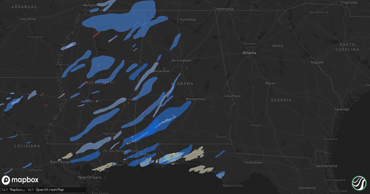
Hail Map in Alabama on March 30, 2022
Get this storm
March 30 map
$229
one time, instant access
Download today. No call, no setup
Keep the $229
Bought the map and want the full workflow? Apply the entire $229 to a subscription within 7 days. None of it is wasted.
Every map, not just this one
This buys you this map. Subscription and you get every map we run, in the markets you choose from a few cities to whole states to nationwide. Plus real-time alerts the moment a storm fires.
Contact data
Name, contact info, occupancy, even credit band for addresses in the footprint. You go from where it hit to who to call.
Become the source they trust
Unlimited branding weather history reports on demand. You already have the documented answer ready for the property owner, and you are the one who showed up with it.
Property data and RoofTrace estimates
Pull up any address you have got, its value and the exact code rules for that jurisdiction, straight from One Click Code. Then RoofTrace estimates the squares, pitch, and roof value, priced the way you price.
Storm reports in Alabama
Alabama
| Date | Description |
|---|---|
| 03/30/202210:23 AM CDT | Two homes were reported to have damage on allen walker road. |
| 03/30/202210:06 AM CDT | Public report of several trees down in a swath over 100 yds wide along bibb cr 29 a mile south of us hwy 82. Less damage observed north of u.s. Hwy 82 but some trees do |
| 03/30/20226:39 AM CDT | At 1138 PM CDT, severe thunderstorms were located along a line extending from near Maylene to near Jemison to near Pooles Crossroads, moving northeast at 55 mph. HAZARD...60 mph wind gusts. SOURCE...Radar indicated. IMPACT...Expect damage to roofs, siding, and trees. Locations impacted include... Hoover, Alabaster, Pelham, Helena, Leeds, Calera, Chelsea, Clanton, Montevallo, Columbiana, Jemison, Wilsonville, Indian Springs Village, Vincent, Thorsby, Harpersville, Westover, Wilton, Gap Of The Mountain and American Village. |
| 03/30/20226:26 AM CDT | At 1125 PM CDT, severe thunderstorms were located along a line extending from 10 miles northeast of Pine Apple to 11 miles west of Poarch Creek Reservation, moving east at 30 mph. HAZARD...60 mph wind gusts. SOURCE...Radar indicated. IMPACT...Expect damage to roofs, siding, and trees. Locations impacted include... Greenville, Monroeville, Evergreen, Frisco City, McCullough, Peterman, Georgiana, Uriah, Castleberry, Excel, Beatrice, Repton, Pine Apple, I65 And US 84, I65 And AL 113, I65 And AL 21 and Poarch Creek Reservation. |
| 03/30/20226:23 AM CDT | At 1122 PM CDT, severe thunderstorms were located along a line extending from near Stapleton to Point Clear to Fort Morgan, moving east at 40 mph. HAZARD...70 mph wind gusts. SOURCE...Radar indicated. IMPACT...Expect considerable tree damage. Damage is likely to mobile homes, roofs, and outbuildings. Locations impacted include... Pensacola, Ferry Pass, Brent, West Pensacola, Ensley, Warrington, Fairhope, Gonzalez, Gulf Shores, Foley, Orange Beach, Goulding, Robertsdale, Point Clear, Lillian, Myrtle Grove, Magnolia Springs, Bon Secour, Summerdale and Silverhill. |
| 03/30/20225:36 AM CDT | At 1036 PM CDT, severe thunderstorms were located along a line extending from 6 miles south of Yellow Bluff to 11 miles southeast of Whatley to 3 miles west of Calvert, moving east at 35 mph. HAZARD...70 mph wind gusts. SOURCE...Radar indicated. IMPACT...Expect considerable tree damage. Damage is likely to mobile homes, roofs, and outbuildings. Locations impacted include... Monroeville, Frisco City, McCullough, Peterman, Uriah, Calvert, Excel, Beatrice, Vredenburgh, Repton, Pine Apple, I65 And US 84, I65 And AL 113, I65 And AL 21 and Poarch Creek Reservation. |
| 03/30/20225:26 AM CDT | At 1024 PM CDT, severe thunderstorms were located along a line extending from near Hazel Green to 7 miles southeast of Helicon, moving east at 40 mph. HAZARD...60 mph wind gusts. SOURCE...Radar indicated. IMPACT...Expect damage to roofs, siding, and trees. Locations impacted include... Huntsville, Madison, Cullman, Hartselle, Winchester, Guntersville, Arab, Fayetteville, Moores Mill and Meridianville. |
| 03/30/20225:17 AM CDT | At 1017 PM CDT, severe thunderstorms were located along a line extending from Consul to 5 miles northeast of Magnolia to 3 miles northeast of Thomasville, moving northeast at 60 mph. HAZARD...70 mph wind gusts. SOURCE...Radar indicated. IMPACT...Expect considerable tree damage. Damage is likely to mobile homes, roofs, and outbuildings. Locations impacted include... Pine Hill. |
| 03/30/20225:11 AM CDT | At 1011 PM CDT, a severe thunderstorm was located near Wade, or near Escatawpa, moving northeast at 35 mph. HAZARD...60 mph wind gusts and quarter size hail. SOURCE...Radar indicated. IMPACT...Hail damage to vehicles is expected. Expect wind damage to roofs, siding, and trees. Locations impacted include... Ocean Springs, Moss Point, Escatawpa, Gautier, Wade, Helena, Big Point, Hurley, Vancleave, Gulf Park Estates, Hickory Hills and Gulf Hills.This includes Interstate 10 in Mississippi between mile markers 54and 76. |
| 03/30/20224:48 AM CDT | At 946 PM CDT, a severe thunderstorm was located 4 miles southwest of Wagarville, or 12 miles southeast of Chatom, moving northeast at 50 mph. THIS IS A DESTRUCTIVE STORM FOR MCINTOSH...HAWTHORN...WAGARVILLE... HAZARD...80 mph wind gusts. SOURCE...Radar indicated. IMPACT...Flying debris will be dangerous to those caught without shelter. Mobile homes will be heavily damaged. Expect considerable damage to roofs, windows, and vehicles. Extensive tree damage and power outages are likely. Locations impacted include... Jackson, Frisco City, Chatom, Saint Stephens, Wagarville, Leroy, Uriah, Whatley, Tibbie, Calvert and McIntosh. |
| 03/30/20224:46 AM CDT | At 946 PM CDT, severe thunderstorms were located along a line extending from near Coker to near Greensboro Municipal Airport, moving northeast at 45 mph. HAZARD...60 mph wind gusts. SOURCE...Radar indicated. IMPACT...Expect damage to roofs, siding, and trees. Locations impacted include... Tuscaloosa, Northport, Brent, Centreville, Greensboro, Holt, Moundville, Lake View, Brookwood, Coaling, Vance, Woodstock, West Blocton, Akron, McFarland Mall, Tuscaloosa Amphitheater, Tuscaloosa Regional Airport, Lake Wildwood, Low Gap and Mertz. |
| 03/30/20224:37 AM CDT | At 936 PM CDT, severe thunderstorms were located along a line extending from 4 miles west of Putnam to 5 miles south of Coffeeville, moving east at 50 mph. HAZARD...70 mph wind gusts. SOURCE...Radar indicated. IMPACT...Expect considerable tree damage. Damage is likely to mobile homes, roofs, and outbuildings. Locations impacted include... Thomasville, Grove Hill, Pine Hill, Coffeeville, Fulton and Yellow Bluff. |
| 03/30/20224:35 AM CDT | At 935 PM CDT, a severe thunderstorm was located 7 miles west of Ardmore, or 12 miles south of Pulaski, moving east at 50 mph. HAZARD...60 mph wind gusts. SOURCE...Radar indicated. IMPACT...Expect damage to roofs, siding, and trees. Locations impacted include... Pulaski, Ardmore, Elkton, Prospect and Frankewing. This includes Interstate 65 between mile markers 1 and 16. |
| 03/30/20224:27 AM CDT | At 926 PM CDT, severe thunderstorms were located along a line extending from Pulaski to near Poplar Springs, moving northeast at 55 mph. HAZARD...60 mph wind gusts. SOURCE...Radar indicated. IMPACT...Expect damage to roofs, siding, and trees. Locations impacted include... Decatur, Madison, Athens, Hartselle, Fayetteville, Moulton, Priceville, Trinity, Falkville and Ardmore. |
| 03/30/20224:01 AM CDT | At 901 PM CDT, severe thunderstorms were located along a line extending from near Belk to near Mantua, moving northeast at 40 mph. HAZARD...60 mph wind gusts. SOURCE...Radar indicated. IMPACT...Expect damage to roofs, siding, and trees. Locations impacted include... Northern Tuscaloosa, Northport, Fayette, Berry, Coker, Belk, Bankston, Samantha, Lake Lurleen State Park, Tuscaloosa Regional Airport, Ashcraft Corner, Boley Springs, Binion Creek Landing, Stone Wall, Whitson, Lake Tuscaloosa, Moores Bridge, Richard Arthur Field, Windham Springs and Flatwoods. |
| 03/30/20223:42 AM CDT | At 841 PM CDT, severe thunderstorms were located along a line extending from 4 miles east of Alamucha to near Crandall to 3 miles west of Waynesboro, moving east at 45 mph. HAZARD...70 mph wind gusts. SOURCE...Radar indicated. IMPACT...Expect considerable tree damage. Damage is likely to mobile homes, roofs, and outbuildings. Locations impacted include... Waynesboro, Butler, Clara, Lisman, State Line, Buckatunna, Silas, Coffeeville, Pennington, Gilbertown and Toxey. |
| 03/30/20223:39 AM CDT | At 838 PM CDT, severe thunderstorms were located along a line extending from near Clara to 7 miles southwest of McLain to 9 miles north of Kiln, moving northeast at 60 mph. HAZARD...70 mph wind gusts. SOURCE...Radar indicated. IMPACT...Expect considerable tree damage. Damage is likely to mobile homes, roofs, and outbuildings. Locations impacted include... Wiggins, Citronelle, Lucedale, Chatom, Richton, Leakesville, Saint Stephens, Wagarville, Clara, Perkinston, McHenry, Gulfcrest, Deer Park, Tibbie, Beaumont, Calvert, Mount Vernon, New Augusta, Millry and McLain. |
| 03/30/20223:38 AM CDT | At 838 PM CDT, severe thunderstorms were located along a line extending from near Loretto to near Brinn, moving northeast at 55 mph. HAZARD...60 mph wind gusts. SOURCE...Radar indicated. IMPACT...Expect damage to roofs, siding, and trees. Locations impacted include... Moulton, Rogersville, Killen, Town Creek, Lexington, Leighton, Courtland, North Courtland, Hillsboro and Anderson. |
| 03/30/20223:25 AM CDT | At 825 PM CDT, a severe thunderstorm was located over De Soto, or near Quitman, moving northeast at 50 mph. HAZARD...60 mph wind gusts. SOURCE...Radar indicated. IMPACT...Expect damage to roofs, siding, and trees. This severe thunderstorm will be near... Sykes and Crandall around 835 PM CDT.Other locations impacted by this severe thunderstorm include Shubuta. |
| 03/30/20223:00 AM CDT | Tree down near highway 167. |
| 03/30/20223:00 AM CDT | At 800 PM CDT, severe thunderstorms were located along a line extending from near Deerbrook to near Stonewall, moving northeast at 55 mph. HAZARD...60 mph wind gusts. SOURCE...Radar indicated. IMPACT...Expect damage to roofs, siding, and trees. Locations impacted include... Demopolis, Livingston, Eutaw, York, Aliceville, Gordo, Reform, Carrollton, Pickensville, Cuba, Forkland, Boligee, Union, Gainesville, Epes, Ethelsville, Emelle, McMullen, Panola and West Greene. |
| 03/30/20222:52 AM CDT | At 752 PM CDT, severe thunderstorms were located along a line extending from near Orange to Heidelberg to 3 miles southwest of Ellisville, moving east at 40 mph. HAZARD...60 mph wind gusts. SOURCE...Radar indicated. IMPACT...Expect damage to roofs, siding, and trees. Locations impacted include... Waynesboro, Butler, Clara, Lisman, State Line, Buckatunna, Silas, Gilbertown and Toxey. |
| 03/30/20222:51 AM CDT | At 751 PM CDT, a severe thunderstorm was located near Red Bay, moving northeast at 60 mph. HAZARD...60 mph wind gusts. SOURCE...Radar indicated. IMPACT...Expect damage to roofs, siding, and trees. Locations impacted include... Red Bay, Vina, Pleasant Site, Pogo, Mynot, Atwood, Maud, Halltown, Little Bear Creek Reservoir and Cedar Creek Reservoir. |
| 03/30/20222:50 AM CDT | Tree down on pool rd. |
| 03/30/20222:40 AM CDT | At 740 PM CDT, severe thunderstorms were located along a line extending from 8 miles southeast of Olive Hill to 6 miles southeast of Red Bay, moving northeast at 40 mph. HAZARD...60 mph wind gusts. SOURCE...Radar indicated. IMPACT...Expect damage to roofs, siding, and trees. Locations impacted include... Florence, Muscle Shoals, Russellville, Sheffield, Tuscumbia, Phil Campbell, Killen, Littleville, Leighton and St. Florian. |
| 03/30/20222:32 AM CDT | At 732 PM CDT, a severe thunderstorm was located near Duffee, or 13 miles west of Meridian, moving northeast at 60 mph. HAZARD...60 mph wind gusts. SOURCE...Radar indicated. IMPACT...Expect damage to roofs, siding, and trees. This severe thunderstorm will be near... Meridian, Suqualena, Martin and Nellieburg around 740 PM CDT. Daleville and Prismatic around 750 PM CDT. Meridian Station and Blackwater around 755 PM CDT. Tamola around 800 PM CDT. Porterville around 805 PM CDT. |
| 03/30/20222:12 AM CDT | At 711 PM CDT, severe thunderstorms were located along a line extending from Decaturville to near Walnut Grove, moving northeast at 70 mph. HAZARD...60 mph wind gusts. SOURCE...Radar indicated. IMPACT...Expect damage to roofs, siding, and trees. Locations impacted include... Hohenwald, Waynesboro, Linden, McEwen, Collinwood, Hurricane Mills, Clifton, Lobelville, Cypress Inn, Flatwoods, I-40 Near The Tennessee River, Bucksnort, Lutts, Mousetail Landing State Park and Pleasantville.This includes Interstate 40 between mile markers 136 and 157. |
| 03/30/20221:40 AM CDT | At 640 PM CDT, a severe thunderstorm was located near Stallo, or 7 miles northwest of Nanih Waiya, moving northeast at 50 mph. HAZARD...60 mph wind gusts. SOURCE...Radar indicated. IMPACT...Expect damage to roofs, siding, and trees. This severe thunderstorm will be near... Mashulaville around 705 PM CDT. Brooksville around 720 PM CDT. Deerbrook around 725 PM CDT.Other locations impacted by this severe thunderstorm includeShuqualak and Noxapater. |
| 03/30/202212:11 AM CDT | Tree and home damage in area associated with tornado debris signature on radar. |
| 03/30/202212:02 AM CDT | Multiple photos and video of timber damage and damage to a portion of a roof on a home. Possible tornado. |
| 03/30/202212:00 AM CDT | Tornado confirmed with radar tds near cr 69 and cr 74. Additional damage was reported along cr 47. |
| 03/30/202212:00 AM CDT | Tornado confirmed with radar tds near cr 69 and cr 74. Additional damage was reported along cr 47. One home had its roof removed. |
| 03/29/202211:58 PM CDT | Tornado confirmed with radar tds. Several home sustained damage... Numerous softwoods were snapped and uprooted... And other barn and small building damage. Path length |
| 03/29/202211:07 PM CDT | Public report of several trees down in a swath over 100 yds wide along bibb cr 29 a mile south of us hwy 82. Less damage observed north of u.s. Hwy 82 but some trees do |
| 03/29/202211:05 PM CDT | Trees and power lines down along with several reports of roof damage in and around camden. |
| 03/29/202210:58 PM CDT | Reports relayed via social media of trees/power lines down near hamilton blvd and rangeline rd in theodore... Al. |
| 03/29/202210:54 PM CDT | Numerous reports of downed power lines and structural damage near rangeline rd. |
| 03/29/202210:40 PM CDT | Photos from broadcast media shared on social media of damage to a barn near safford in dallas county. |
| 03/29/202210:34 PM CDT | Reports of trees down and damaged structures near wulff road south and howells ferry road. |
| 03/29/202210:27 PM CDT | Marengo county ema reports a roof removed from a cafã©... Sidewall removed from a coop building... Other businesses damaged in the faunsdale area. Possible tornado. |
| 03/29/202210:27 PM CDT | Marengo county ema reports a roof removed from a café... Sidewall removed from a coop building... Other businesses damaged in the faunsdale area. Possible tornado. |
| 03/29/202210:27 PM CDT | Roof damage to brooke hall on university of montevallo campus. Windows were blown out of a residence hall. A few trees were also blown down in the same area. Possible t |
| 03/29/202210:27 PM CDT | Roof damage to brooke hall on montevallo campus. Apparent latter portion of a tornado track. |
| 03/29/202210:27 PM CDT | Roof damage to brooke hall on montevallo campus. Possible latter portion of a tornado track. |
| 03/29/202210:27 PM CDT | Roof damage to brooke hall on university of montevallo campus. Possible associated with latter part of tornado track. |
| 03/29/202210:25 PM CDT | Public report of a roof removed that was covering a drop-off point at the wilton bible baptist church in wilton... Southwest of montevallo. |
| 03/29/202210:23 PM CDT | Small trees blocking one lane of hwy 80 and reports of other damage in faunsdale. |
| 03/29/202210:23 PM CDT | Corrects previous tstm wnd dmg report from 1 ne faunsdale. Several trees down in the area... Some blocking roadways. Faunsdale bar and grill and faunsdale coop sustaine |
| 03/29/202210:23 PM CDT | Several trees down in the area... Some blocking roadways. Faunsdale bar and grill and faunsdale coop sustained roof damage. Possible tornado. |
| 03/29/202210:18 PM CDT | *** 1 inj *** trees down on ashby road and nearby roads. One manufactured home overturned near booth lane were an injury occurred. Tornado confirmed due to tds on radar |
| 03/29/202210:18 PM CDT | Trees down on west ashby road and nearby roads. In line with tornado track. |
| 03/29/202210:18 PM CDT | Trees down on ashby road and nearby roads. One manufactured home overturned near booth lane. Possible tornado. |
| 03/29/202210:18 PM CDT | Trees down on ashby road and nearby roads. Likely part of a tornado track. |
| 03/29/202210:11 PM CDT | Tds noted on radar. |
| 03/29/202210:10 PM CDT | Continuing tds. |
| 03/29/202210:07 PM CDT | Corrects previous tornado report from trio. Public report of several trees down in a swath over 100 yds wide along bibb cr 29 a mile south of us hwy 82. Less damage obs |
| 03/29/20229:54 PM CDT | Tds noted on radar reaching at least 13...000 feet in the next few scans. Either a new tornado or continuation of the prior. |
| 03/29/20229:49 PM CDT | Report from broadcast media and from the public about wind damage to the 69 south flea market in moundville. Several trees nearby reported to be uprooted. |
| 03/29/20229:45 PM CDT | Photos from broadcast media shared via social media of a large tree on a house... Significant damage to a structure... With a mobile/manufactured home removed from its |
| 03/29/20229:44 PM CDT | Marengo county ema reports damage to several houses and mobile homes. 2 houses and 4 mobile homes with significant damage. Awaiting additional more detailed information |
| 03/29/20229:44 PM CDT | Social media posts from multiple broadcast media sources showing multiple mobile homes damaged... Over 50 trees reported down with highway 10 and cr 9 roads blocked. Po |
| 03/29/20229:42 PM CDT | Corrects previous report from 4 n putnam for event type. Tds noted on radar. |
| 03/29/20229:42 PM CDT | Tds noted on radar. |
| 03/29/20229:34 PM CDT | Corrects previous tstm wnd dmg report from 4 ssw knoxville. Public report of several housed damaged... Trees down on the cloverdale hardware store and additional struct |
| 03/29/20229:34 PM CDT | Tds noted on radar. |
| 03/29/20229:34 PM CDT | Public report of several housed damaged... Trees down on the cloverdale hardware store and additional structural damage in the area. Time and location approximate. |
| 03/29/20229:18 PM CDT | Tds noted on radar. |
| 03/29/20229:17 PM CDT | Reports of tree damage a few miles south of gilbertown... Al. |
| 03/29/20229:15 PM CDT | Emergency management reported structural damage at southern choctaw high school including a smashed scoreboard... Shifted poles... And roof/awning damage. A school bus |
| 03/29/20229:15 PM CDT | Corrects previous tstm wnd dmg report from 1 se echola. Public report of damage to trees close to the intersection of boyd road and upper columbus rd. Updated: damage t |
| 03/29/20229:15 PM CDT | Public report of damage to trees close to the intersection of boyd road and upper columbus rd. Possible tornado. |
| 03/29/20229:11 PM CDT | Tornado debris signature noted on radar. |
| 03/29/20229:11 PM CDT | Greene county ema reports 13 mobile/manufactured homes damaged and at least 3 destroyed. Multiple trees down in the area and power remains out. Awaiting additional deta |
| 03/29/20229:03 PM CDT | Damage to a mobile/manufactured home. Two barns were destroyed and another building was destroyed. Vehicles were also damaged. Possible tornado. |
| 03/29/20229:03 PM CDT | Damage to a mobile/manufactured home. Possible extension of the tds track noted to the northeast. |
| 03/29/20228:58 PM CDT | A tree was reported down at the intersection of wheeler view dr and river road. |
| 03/29/20228:54 PM CDT | Trees and powerlines down on cr 12 just off 11. |
| 03/29/20228:53 PM CDT | Tornado debris signature noted on radar. Damage reported including snapped trees and structural damage. |
| 03/29/20228:47 PM CDT | Trees down on cr2. |
| 03/29/20228:22 PM CDT | A roof was blown off of a church... Unknown damage to a home... And numerous trees down in the central heights community. |
| 03/29/20228:06 PM CDT | Trees and powerlines down near colbert ferry boat ramp. |
| 03/29/20228:04 PM CDT | Trees and powerlines down along north pike in cherokee. |
| 03/29/20228:00 PM CDT | Scattered trees and power lines down across the western part of the county. |
| 03/29/20227:59 PM CDT | Several trees were down in the western part of the county as line of storms moved through. |
| 03/29/20227:41 PM CDT | A tree was reported down at 6220 north pike road. |
| 03/29/20227:28 PM CDT | A tree was reported down on milk springs road. |
All States Impacted by Hail Map on March 30, 2022
Cities Impacted by Hail Map on March 30, 2022
- Milton, FL
- Cantonment, FL
- Diamondhead, MS
- Port Allen, LA
- Baton Rouge, LA
- Defuniak Springs, FL
- Panama City Beach, FL
- Panama City, FL
- Inlet Beach, FL
- Santa Rosa Beach, FL
- Summerdale, AL
- Vredenburgh, AL
- Franklin, AL
- Peterman, AL
- Beatrice, AL
- Pass Christian, MS
- Bagdad, FL
- Robertsdale, AL
- Holt, FL
- Pensacola, FL
- Elberta, AL
- Lillian, AL
- Seminole, AL
- Eglin Afb, FL
- Whatley, AL
- Jackson, AL
- Grove Hill, AL
- Gainestown, AL
- Theriot, LA
- Freeport, FL
- Ponce De Leon, FL
- Foley, AL
- Pine Apple, AL
- Leakesville, MS
- Niceville, FL
- Westville, FL
- Valparaiso, FL
- Crestview, FL
- Moss Point, MS
- Citronelle, AL
- Deer Park, AL
- Zachary, LA
- Holden, LA
- Greenwell Springs, LA
- Pride, LA
- Amite, LA
- Pine Grove, LA
- Walker, LA
- Denham Springs, LA
- Baker, LA
- Fairhope, AL
- Vancleave, MS
- Gulf Breeze, FL
- Coden, AL
- Bayou La Batre, AL
- Daphne, AL
- Theodore, AL
- Irvington, AL
- Long Beach, MS
- Gulfport, MS
- Waveland, MS
- Kiln, MS
- Pearlington, MS
- Bay Saint Louis, MS
- Slidell, LA
- New Orleans, LA
- Lucedale, MS
- McIntosh, AL
- Sunflower, AL
- Tibbie, AL
- Wagarville, AL
- Vinegar Bend, AL
- Echola, AL
- Eutaw, AL
- Berry, AL
- Aliceville, AL
- Porterville, MS
- Coker, AL
- Northport, AL
- Buhl, AL
- Elrod, AL
- Scooba, MS
- Carrollton, AL
- Gordo, AL
- Emelle, AL
- Epes, AL
- Cuba, AL
- Meridian, MS
- Forkland, AL
- Boligee, AL
- Akron, AL
- Livingston, AL
- Knoxville, AL
- Gainesville, AL
- Moundville, AL
- Toomsuba, MS
- York, AL
- Fosters, AL
- Lawley, AL
- Selma, AL
- Uniontown, AL
- Thomasville, AL
- Randolph, AL
- Marion, AL
- Thomaston, AL
- Marion Junction, AL
- Centreville, AL
- Montevallo, AL
- Brierfield, AL
- Safford, AL
- Catherine, AL
- Arlington, AL
- Pine Hill, AL
- Reform, AL
- Ethelsville, AL
- Shuqualak, MS
- Brooksville, MS
- Macon, MS
- Dennis, MS
- Mantachie, MS
- Tremont, MS
- Vina, AL
- Russellville, AL
- Cherokee, AL
- Muscle Shoals, AL
- Golden, MS
- Belmont, MS
- Town Creek, AL
- Courtland, AL
- Tuscumbia, AL
- Rogersville, AL
- Hillsboro, AL
- Red Bay, AL
- Sheffield, AL
- Fulton, MS
- Killen, AL
- Leighton, AL
- Nettleton, MS
- Dixons Mills, AL
- Campbell, AL
- Faunsdale, AL
- Coffeeville, AL
- Butler, AL
- Buckatunna, MS
- Gilbertown, AL
- Richton, MS
- Toxey, AL
- Magnolia, AL
- Millry, AL
- Waynesboro, MS
- Linden, AL
- Sweet Water, AL
- Newbern, AL
- Silas, AL
- Laurel, MS
- Bremen, AL
- Arley, AL
- Logan, AL
- Falkville, AL
- Cullman, AL
- Jasper, AL
- Vinemont, AL
- Crane Hill, AL
- Alberta, AL
- Orrville, AL
- Wilmer, AL
- Creola, AL
- Semmes, AL
- Eight Mile, AL
- Satsuma, AL
- Mobile, AL
- Bay Minette, AL
- Saraland, AL
- Perdido, AL
- Pascagoula, MS
- Stapleton, AL
- Loxley, AL
- Ocean Springs, MS
- Grand Bay, AL
- Gautier, MS
- Elm Grove, LA
- Shreveport, LA
- Bossier City, LA
- Doyline, LA
- Minden, LA
- Castor, LA
- Ringgold, LA
- Coushatta, LA
- Hall Summit, LA
- Burkeville, TX
- Anacoco, LA
- Florien, LA
- Hornbeck, LA
- Bienville, LA
- Jonesboro, LA
- Ruston, LA
- Choudrant, LA
- Saline, LA
- Quitman, LA
- Chatham, LA
- Eros, LA
- Goldonna, LA
- Simsboro, LA
- Arcadia, LA
- Leesville, LA
- Sieper, LA
- Elmer, LA
- Otis, LA
- Boyce, LA
- West Monroe, LA
- Monroe, LA
- Iowa, LA
- Bell City, LA
- Welsh, LA
- Cheneyville, LA
- Tallulah, LA
- Vicksburg, MS
- Church Point, LA
- Crowley, LA
- Sunset, LA
- Branch, LA
- Rayne, LA
- Iota, LA
- Covington, LA
- Folsom, LA
- Carriere, MS
- Albany, LA
- Springfield, LA
- Poplarville, MS
- Livingston, LA
- Bush, LA
- Hammond, LA
- Ponchatoula, LA
- Picayune, MS
- Franklinton, LA
- Bogalusa, LA
- Tickfaw, LA
- Loranger, LA
- Robert, LA
- Abita Springs, LA
- Roseland, LA
- Columbia, MS
- Mount Hermon, LA
- Purvis, MS
- Hattiesburg, MS
- Independence, LA
- Angie, LA
- Kentwood, LA
- Lumberton, MS
- Tylertown, MS
- Sandy Hook, MS
- Many, LA
- Oakfield, TN
- Mercer, TN
- Lavinia, TN
- Jackson, TN
- Denmark, TN
- Toone, TN
- Moscow, TN
- Arlington, TN
- Milan, TN
- Eads, TN
- Somerville, TN
- Whiteville, TN
- Holly Springs, MS
- Williston, TN
- Rossville, TN
- Cordova, TN
- Medina, TN
- Collierville, TN
- Humboldt, TN
- Oakland, TN
- Byhalia, MS
- Bolivar, TN
- Medon, TN
- Olive Branch, MS
- Memphis, TN
- Germantown, TN
- Horn Lake, MS
- Southaven, MS
- Walls, MS
- Gracey, KY
- Fort Campbell, KY
- Cadiz, KY
- Bumpus Mills, TN
- Cerulean, KY
- Hopkinsville, KY
- Springville, TN
- Herndon, KY
- Crofton, KY
- Stewart, TN
- Paris, TN
- La Fayette, KY
- Big Sandy, TN
- Dover, TN
- Big Rock, TN
- Linden, TN
- Eva, TN
- Waverly, TN
- Sugar Tree, TN
- Holladay, TN
- Lobelville, TN
- Hollow Rock, TN
- New Johnsonville, TN
- Woodlawn, TN
- Cunningham, TN
- Parsons, TN
- Erin, TN
- Vanleer, TN
- Dickson, TN
- Palmyra, TN
- Bruceton, TN
- McEwen, TN
- Nunnelly, TN
- Buena Vista, TN
- Only, TN
- Cumberland City, TN
- Hurricane Mills, TN
- Indian Mound, TN
- Centerville, TN
- Cumberland Furnace, TN
- Tennessee Ridge, TN
- Camden, TN
- Charlotte, TN
- Thompsons Station, TN
- Brentwood, TN
- Franklin, TN
- Minter City, MS
- Itta Bena, MS
- Holcomb, MS
- Greenwood, MS
- Leland, MS
- Charleston, MS
- Philipp, MS
- Chatham, MS
- Sunflower, MS
- Glen Allan, MS
- Inverness, MS
- Schlater, MS
- Hollandale, MS
- Moorhead, MS
- Indianola, MS
- Greenville, MS
- Belzoni, MS
- Sidon, MS
- Isola, MS
- Duncan, MS
- Rosedale, MS
- Mound Bayou, MS
- Tutwiler, MS
- Watson, AR
- Shelby, MS
- Clarksdale, MS
- Gunnison, MS
- Bolton, MS
- Flora, MS
- Bentonia, MS
- Yazoo City, MS
- Benton, MS
- Byram, MS
- Raymond, MS
- Utica, MS
- Terry, MS
- West, MS
- French Camp, MS
- Kilmichael, MS
- Coila, MS
- Durant, MS
- Eupora, MS
- Walthall, MS
- Duck Hill, MS
- Vaiden, MS
- Stewart, MS
- Cruger, MS
- Ackerman, MS
- Ethel, MS
- Winona, MS
- Lexington, MS
- Mathiston, MS
- McCarley, MS
- North Carrollton, MS
- Weir, MS
- Carrollton, MS
- Jackson, MS
- Flowood, MS
- Pearl, MS
- Lena, MS
- Canton, MS
- Brandon, MS
- Stantonville, TN
- Tupelo, MS
- Crump, TN
- Olivehill, TN
- Crenshaw, MS
- Hickory Flat, MS
- Glen, MS
- Thaxton, MS
- Batesville, MS
- Abbeville, MS
- Iuka, MS
- Iron City, TN
- Ecru, MS
- Sardis, MS
- Adamsville, TN
- Burnsville, MS
- Myrtle, MS
- Lutts, TN
- Lamar, MS
- Dundee, MS
- Hernando, MS
- Michigan City, MS
- Ripley, MS
- Selmer, TN
- Shiloh, TN
- Etta, MS
- Blue Springs, MS
- Blue Mountain, MS
- Cypress Inn, TN
- Falkner, MS
- Tiplersville, MS
- Savannah, TN
- Dumas, MS
- Counce, TN
- Senatobia, MS
- Waynesboro, TN
- Baldwyn, MS
- Rienzi, MS
- Florence, AL
- Michie, TN
- Como, MS
- Potts Camp, MS
- Waterford, MS
- Red Banks, MS
- Saltillo, MS
- Coldwater, MS
- Booneville, MS
- Ashland, MS
- Marietta, MS
- Oxford, MS
- Guys, TN
- Sarah, MS
- Waterloo, AL
- Tunica, MS
- Tishomingo, MS
- Ramer, TN
- New Albany, MS
- Collinwood, TN
- Corinth, MS
- Walnut, MS
- Guntown, MS
- McCool, MS
- Sallis, MS
- Carthage, MS
- Starkville, MS
- Kosciusko, MS
- Goodman, MS
- Noxapater, MS
- Philadelphia, MS
- Camden, MS
- Louisville, MS
- Sturgis, MS
- Bruce, MS
- Banner, MS
- Pontotoc, MS
- Randolph, MS
- Mccomb, MS
- Collins, MS
- Taylorsville, MS
- Monticello, MS
- Mendenhall, MS
- Rose Hill, MS
- Bay Springs, MS
- Louin, MS
- Pinola, MS
- Mize, MS
- Oak Vale, MS
- Ruth, MS
- Smithdale, MS
- Soso, MS
- Prentiss, MS
- Mount Olive, MS
- Summit, MS
- Liberty, MS
- Newhebron, MS
- Stringer, MS
- Magee, MS
- Paulding, MS
- Magnolia, MS
- Silver Creek, MS
- Jayess, MS
- Shannon, MS
- Verona, MS
- Mooreville, MS
- Plantersville, MS
- New Site, MS
- Hickory, MS
- Chunky, MS
- Raleigh, MS
- Lawrence, MS
- Enterprise, MS
- Forest, MS
- Newton, MS
- Braxton, MS
- Aberdeen, MS
- Crawford, MS
- Columbus, MS
- Amory, MS
- Brooklyn, MS
- Wiggins, MS
- Petal, MS
- New Augusta, MS
- Fort Deposit, AL
- Lower Peach Tree, AL
- Hayneville, AL
- Minter, AL
- Monroeville, AL
- Letohatchee, AL
- Leroy, AL
- Coy, AL
- Beaumont, MS
- McLain, MS
- Saint Stephens, AL
- Hope Hull, AL
- Fruitdale, AL
- Lowndesboro, AL
- Camden, AL
- Greenville, AL
- Little River, AL
- Frisco City, AL
- Prattville, AL
- Uriah, AL
- Montgomery, AL
- Tyler, AL
- State Line, MS
- Neely, MS
- Dickinson, AL
- Forest Home, AL
- Perkinston, MS
- Rayville, LA
- Lacombe, LA
- Cottondale, AL
- Tuscaloosa, AL
- Columbiana, AL
- Chipley, FL
- Alford, FL
- Cottondale, FL
- Hemphill, TX
- Natchitoches, LA
- Campti, LA
- Winnsboro, LA
- Cleveland, MS
- Courtland, MS
- Pope, MS
- Enid, MS
- Huntingdon, TN
- Thompsonville, IL
- Macedonia, IL
- Carmi, IL
- Evansville, IN
- Fairfield, IL
- Crossville, IL
- Norris City, IL
- Cove, AR
- Hatfield, AR
- Mena, AR
- Paragould, AR
- Bono, AR
- Ripley, TN
- Luxora, AR
- Finley, TN
- Dyersburg, TN
- Lenox, TN
- Halls, TN
- Blytheville, AR
- Henning, TN
- Osceola, AR
- Baker, FL
- Laurel Hill, FL
- Marianna, FL
- Wewahitchka, FL
- Port Saint Joe, FL
- Kevil, KY
- West Paducah, KY
- Paducah, KY
- Boaz, KY
- Hickory, KY
- Fancy Farm, KY
- Melber, KY
- Mayfield, KY
- Uniontown, KY
- Corydon, KY
- Waverly, KY
- Henderson, KY
- Morganfield, KY
- Sturgis, KY
- Owensboro, KY
- Calhoun, KY
- Madisonville, KY
- Sebree, KY
- Rockport, IN
- Hanson, KY
- Slaughters, KY
- Nebo, KY
- Rumsey, KY
- Manitou, KY
- Utica, KY
- Dawson Springs, KY
- Robards, KY
- Richland, IN


