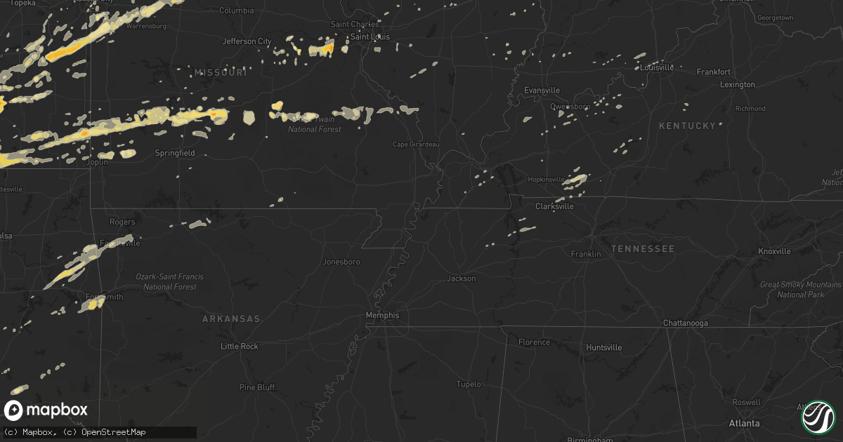
Hail Map in Missouri on February 27, 2011
Get this storm
February 27 map
$229
one time, instant access
Download today. No call, no setup
Keep the $229
Bought the map and want the full workflow? Apply the entire $229 to a subscription within 7 days. None of it is wasted.
Every map, not just this one
This buys you this map. Subscription and you get every map we run, in the markets you choose from a few cities to whole states to nationwide. Plus real-time alerts the moment a storm fires.
Contact data
Name, contact info, occupancy, even credit band for addresses in the footprint. You go from where it hit to who to call.
Become the source they trust
Unlimited branding weather history reports on demand. You already have the documented answer ready for the property owner, and you are the one who showed up with it.
Property data and RoofTrace estimates
Pull up any address you have got, its value and the exact code rules for that jurisdiction, straight from One Click Code. Then RoofTrace estimates the squares, pitch, and roof value, priced the way you price.
Storm reports in Missouri
Missouri
| Date | Description |
|---|---|
| 02/27/20115:45 PM CST | Hail covering highway 63 has caused car accidents |
| 02/27/20115:38 PM CST | Time estimated. |
| 02/27/20115:28 PM CST | A local report indicates 1.00 inch wind near GROVESPRING |
| 02/27/20114:35 PM CST | A local report indicates 1.00 inch wind near 3 NNE PITTSVILLE |
| 02/27/20114:18 PM CST | A local report indicates 1.00 inch wind near PLEASANT HILL |
| 02/27/20114:10 PM CST | A local report indicates 1.75 inch wind near RAYMORE |
| 02/27/20114:06 PM CST | A local report indicates 1.25 inch wind near 3 N HARRISONVILLE |
| 02/27/20114:01 PM CST | A local report indicates 1.00 inch wind near 3 W FREEMAN |
| 02/27/201110:28 AM CST | A local report indicates 1.00 inch wind near GROVESPRING |
| 02/27/20111:31 AM CST | Quarter size hail reported at the county sheriffs office. |
| 02/27/20111:15 AM CST | Power lines down...large tree snapped...roof blown off a barn. |
| 02/27/20111:02 AM CST | A local report indicates 1.00 inch wind near FARMINGTON |
| 02/26/201111:40 PM CST | A local report indicates 1.75 inch wind near LAKE SPRING |
| 02/26/201111:30 PM CST | On christopher dr... Large older tree down partially blocking road... And a car port blown over and collapsed. This damage viewed enroute to work this morning. |
| 02/26/201111:30 PM CST | Large pine tree 35 to 40 foot tall uprooted. Also one storage shed overturned. |
| 02/26/201111:29 PM CST | Pea sizee hail |
| 02/26/201111:28 PM CST | A local report indicates 1.00 inch wind near GROVESPRING |
| 02/26/201111:27 PM CST | Storm spotter reports funnel cloud near concord village causing power flashes |
| 02/26/201111:27 PM CST | I-44 closed in both directions between hampton and kings highway...debris in the highway. |
| 02/26/201111:25 PM CST | Big bend blvd closed in clayton due to numerous power poles down. |
| 02/26/201111:25 PM CST | A local report indicates 60 MPH wind near BALLWIN |
| 02/26/201111:25 PM CST | Numerous 4 to 5 inch diamter limbs down... Est 2 foot diameter tree branch down. |
| 02/26/201111:25 PM CST | Trees blown down in ballwin |
| 02/26/201111:22 PM CST | A local report indicates 67 MPH wind near 1 SSW HAZELWOOD |
| 02/26/201111:22 PM CST | 70 mph winds reported at 270 and 70 with large hail of unknown size |
| 02/26/201111:15 PM CST | Power lines down |
| 02/26/201111:15 PM CST | 3-5 inch diameter tree limbs broken...heavy lawn furniture blown into fence |
| 02/26/201111:15 PM CST | Shingles removed from house...chimney blown off nearby house |
| 02/26/201111:15 PM CST | Ronnies movie sign is blown down...street signs on lindburgh blown down...signs on i-270 between gravois and tesson ferrry are bent and twisted |
| 02/26/201111:15 PM CST | A local report indicates 60 MPH wind near ELLISVILLE |
| 02/26/201111:14 PM CST | Homes damaged in st. Albans |
| 02/26/201111:10 PM CST | One 4 to 5 inch diameter tree snapped off at nws st louis office. Time estimated from radar. |
| 02/26/201111:10 PM CST | A local report indicates 68 MPH wind near 3 W CHESTERFIELD |
| 02/26/201111:09 PM CST | A local report indicates 1.75 inch wind near 4 SW LEBANON |
| 02/26/201111:00 PM CST | Structural damage reported at balducci vineyards. |
| 02/26/201111:00 PM CST | A local report indicates 1.00 inch wind near BUFFALO |
| 02/26/201111:00 PM CST | A local report indicates 1.75 inch wind near VILLA RIDGE |
| 02/26/201111:00 PM CST | Large barn destroyed. Debris thrown several hundred yards. |
| 02/26/201110:55 PM CST | Pole barn flattened... Metal roof on a garage peeled back... Roof shingles blown off several houses... Several trees snapped off. Time approximate... 1050 to 1055 pm. |
| 02/26/201110:54 PM CST | Power lines down |
| 02/26/201110:53 PM CST | Several trees fell onto houses. Wires down and utility poles snapped. |
| 02/26/201110:50 PM CST | Tree limb blown through the side of a moble home...no injuries reported. |
| 02/26/201110:48 PM CST | A local report indicates 1.75 inch wind near 6 E DRAKE |
| 02/26/201110:46 PM CST | A local report indicates 1.50 inch wind near 4 SE LEBANON |
| 02/26/201110:43 PM CST | Correction for location. |
| 02/26/201110:35 PM CST | A local report indicates 1.00 inch wind near FRANKFORD |
| 02/26/201110:30 PM CST | Numerous power lines...trees and tree limbs blown down in owensville and rosebud. Also...a building in owensville had its awning blown off which damaged the facade. |
| 02/26/201110:30 PM CST | A local report indicates 60 MPH wind near OWENSVILLE |
| 02/26/201110:30 PM CST | Numerous trees uprooted. Time estimated by radar. |
| 02/26/201110:29 PM CST | Also measured 40 kt wind gust. |
| 02/26/201110:28 PM CST | A local report indicates 1.00 inch wind near GROVESPRING |
| 02/26/201110:25 PM CST | Law enforcement reports large tree down across missouri route cc north of stockton reservoir. |
| 02/26/201110:25 PM CST | A local report indicates 1.25 inch wind near 3 E BUFFALO |
| 02/26/201110:25 PM CST | Law enforcement reports large tree down across missouri route cc north of stockton reservoir...correction for location. |
| 02/26/201110:21 PM CST | Correction for time. |
| 02/26/201110:18 PM CST | Law enforcement reported half dollar sized hail...corrected hail size. |
| 02/26/201110:16 PM CST | A local report indicates 60 MPH wind near ASHBURN |
| 02/26/201110:16 PM CST | A local report indicates 1.00 inch wind near HALF WAY |
| 02/26/201110:15 PM CST | Several reports of high winds with no estimated speeds...carport blew into road...pea sized hail |
| 02/26/201110:15 PM CST | A local report indicates 1.00 inch wind near BENNETT SPRINGS |
| 02/26/201110:10 PM CST | Emergency manager reported trees down and power out in half way. Corrected time and event type. |
| 02/26/201110:06 PM CST | 1 ft diameter trees knocked down...sheds damaged |
| 02/26/201110:05 PM CST | A local report indicates 1.00 inch wind near FRANKFORD |
| 02/26/201110:00 PM CST | Spotter estimates winds were at least 60 mph with trees uprooted...shingles tore off of home...tin ripped from barn roofs and pea size hail 1 inch deep |
| 02/26/201110:00 PM CST | Law enforcement reports power polls/lines down in marys home. |
| 02/26/201110:00 PM CST | Tree damage...fence damaged |
| 02/26/20119:50 PM CST | Roof removed from house...several barns destroyed...billboards blown down...power poles blown down...stop signs snapped in half. |
| 02/26/20119:50 PM CST | Extensive roof damage to a home on hwy y |
| 02/26/20119:47 PM CST | A local report indicates 65 MPH wind near PERRY |
| 02/26/20119:30 PM CST | Public report of quarter sized hail. |
| 02/26/20119:25 PM CST | Roof off of a business. Report via morgan county 911. Time estimated. |
| 02/26/20119:21 PM CST | A local report indicates 1.50 inch wind near 2 W LONG LANE |
| 02/26/20118:52 PM CST | Law enforcement reported roof of hog barn removed. |
| 02/26/20118:05 PM CST | Smaller trees uprooted... Shingles torn off houses. |
| 02/26/20117:45 PM CST | 4 foot diameter tree blown down across roadway. Falling tree crushed car and took down power lines. |
| 02/26/20117:44 PM CST | Two reports of 24-36 inch diameter trees blown down. One was across a road. Officer reported that roots were pulled out of the ground. |
| 02/26/20117:40 PM CST | One plane flipped over at airport... Several other planes damaged... Minor structural damage to a hangar |
| 02/26/20117:40 PM CST | A local report indicates 70 MPH wind near 6 SE PALMYRA |
| 02/26/20117:39 PM CST | A local report indicates 87 MPH wind near 3 WNW HANNIBAL |
| 02/26/20117:35 PM CST | Dime to quarter sized hail reported |
| 02/26/20116:45 PM CST | Swing set blown 150 feet t to the southeast...along with damage to 4 to 5 inch limbs |
| 02/26/20116:45 PM CST | Confirmed ef0 tornado...wind estimated 90 mph. 0.5 mile south of shelbina missouri on hwy 15. Damage path 0.5 mile long 20 to 30 yds wide. Machine shed partially destro |
| 02/26/20116:45 PM CST | Barn blown down and trees damaged. Time corrected by spotter followup in area. |
| 02/26/20116:45 PM CST | Several barns with roofs blown off at county road ww and highway 15. Roofs also blown off 2 machine sheds and 3 grain bins blown over. Multiple power poles snapped and |
| 02/26/20116:25 PM CST | Possible tornado. Significant roof damage to home...destruction of garage...tractor trailer and cars blown off road. Time estimated. |
| 02/26/20116:05 PM CST | Relayed through media. Blew a lawn windmill through a residence window. |
| 02/26/20116:01 PM CST | Barn blown down and trees damaged. Time estimated from radar. |
| 02/26/20116:00 PM CST | Wooden fence blown down and debris scattered power pole also snapped. Time estimated from radar. |
All States Impacted by Hail Map on February 27, 2011
Cities Impacted by Hail Map on February 27, 2011
- Champaign, IL
- Howard, KS
- Eaton, OH
- Richmond, IN
- Higginsville, MO
- Stewart, TN
- Greenfield, MO
- Arcola, MO
- Lockwood, MO
- Goldthwaite, TX
- Hamilton, TX
- Frontenac, KS
- Pittsburg, KS
- East Saint Louis, IL
- Eureka, MO
- Pacific, MO
- Pleasant Hill, MO
- Harrisonville, MO
- Huntsville, MO
- Winchester, IN
- Greenview, IL
- Long Lane, MO
- Buffalo, MO
- Stuart, OK
- Climax Springs, MO
- Edwards, MO
- Wellsville, KS
- Ottawa, KS
- Edgerton, KS
- Boss, MO
- Bixby, MO
- Westville, OK
- Summers, AR
- Proctor, OK
- Nashoba, OK
- Yellville, AR
- Wichita, KS
- Winamac, IN
- Oblong, IL
- Willow Hill, IL
- West Liberty, IL
- Greenwood, IN
- Indianapolis, IN
- Green Valley, IL
- Ballwin, MO
- Chesterfield, MO
- Virgil, KS
- Fall River, KS
- Neal, KS
- Rosalia, KS
- Beaumont, KS
- Leon, KS
- Piedmont, KS
- Toronto, KS
- Severy, KS
- Eureka, KS
- La Grange, MO
- Harmony, IN
- Knightsville, IN
- Reelsville, IN
- Terre Haute, IN
- Cloverdale, IN
- Amo, IN
- Clayton, IN
- Greencastle, IN
- Carbon, IN
- Danville, IN
- Brazil, IN
- Fillmore, IN
- Rosedale, IN
- Coatesville, IN
- Putnamville, IN
- El Dorado, KS
- Cassoday, KS
- Burns, KS
- Princeton, IN
- Frost, TX
- Mcalester, OK
- Mount Sterling, MO
- Hermann, MO
- Linn, MO
- Bland, MO
- Owensville, MO
- Staunton, IL
- Valley Mills, TX
- Jonesboro, TX
- Gatesville, TX
- Mattoon, IL
- Lerna, IL
- Windsor, IL
- Gays, IL
- Cottonwood Falls, KS
- Elmdale, KS
- Gardner, KS
- Spring Hill, KS
- Shelbina, MO
- Deer Creek, OK
- Medford, OK
- Salem, MO
- West Salem, IL
- Avon, IN
- Brownsburg, IN
- Licking, MO
- Raymondville, MO
- Bowie, TX
- Montague, TX
- Meridian, TX
- Clifton, TX
- Petersburg, IL
- Cumby, TX
- Lone Oak, TX
- Brashear, TX
- Campbell, TX
- Benton, KS
- Valley Center, KS
- Centerville, KS
- Jerico Springs, MO
- Augusta, MO
- Coatsburg, IL
- Payson, IL
- Clayton, IL
- Paloma, IL
- Quincy, IL
- Camp Point, IL
- Fowler, IL
- Liberty, IL
- Palmyra, MO
- Lewisburg, OH
- Bolivar, MO
- Half Way, MO
- Bloomington, IL
- Italy, TX
- Milford, TX
- Sherman, TX
- Farmington, MO
- Ashmore, IL
- Charleston, IL
- Trilla, IL
- Neoga, IL
- Saint Louis, MO
- Columbus, KS
- Scammon, KS
- Mode, IL
- Cowden, IL
- Beecher City, IL
- Shelbyville, IL
- Colony, KS
- Westphalia, KS
- Stockton, MO
- Coffeyville, KS
- Dexter, KS
- Shidler, OK
- Maple City, KS
- Peru, KS
- Caney, KS
- Independence, KS
- Cedar Vale, KS
- Niotaze, KS
- Sedan, KS
- Havana, KS
- Lewistown, IL
- Lamar, MO
- Argonia, KS
- Washington, MO
- Labadie, MO
- Gray Summit, MO
- Union, MO
- Villa Ridge, MO
- Lincoln, IL
- New Holland, IL
- Stanford, IL
- Armstrong, MO
- Garnett, KS
- Salisbury, MO
- Bates City, MO
- Blackburn, MO
- Sweet Springs, MO
- Kingsville, MO
- Greenwood, MO
- Mayview, MO
- Freeman, MO
- Peculiar, MO
- Cleveland, MO
- Holden, MO
- Clifton Hill, MO
- Glasgow, MO
- Paola, KS
- Drexel, MO
- Concordia, MO
- Centerview, MO
- Higbee, MO
- Malta Bend, MO
- La Cygne, KS
- Warrensburg, MO
- Miami, MO
- Gilliam, MO
- Fontana, KS
- Raymore, MO
- Dalton, MO
- Greeley, KS
- Fayette, MO
- Parker, KS
- Marshall, MO
- Rantoul, KS
- Strasburg, MO
- Odessa, MO
- Lone Jack, MO
- Lane, KS
- Alma, MO
- Keytesville, MO
- Osawatomie, KS
- Slater, MO
- Richmond, KS
- Louisburg, KS
- Noblesville, IN
- Ashland, IL
- Tallula, IL
- Browning, IL
- Havana, IL
- Astoria, IL
- Rushville, IL
- Vermont, IL
- Kansas City, KS
- Clarksville, TN
- Mill Creek, OK
- Macomb, IL
- Cicero, IN
- Prairie Village, KS
- Madill, OK
- Delavan, IL
- Emden, IL
- Chrisman, IL
- Paris, IL
- Clinton, IN
- Milford Center, OH
- San Jose, IL
- Ipava, IL
- Rolla, MO
- Saint James, MO
- Welda, KS
- Le Roy, KS
- Neosho Falls, KS
- Kincaid, KS
- Girard, KS
- Cherokee, KS
- Liberal, MO
- Mindenmines, MO
- Arcanum, OH
- New Madison, OH
- Ellery, IL
- Albion, IL
- Park Hill, OK
- Vian, OK
- Bunch, OK
- Gore, OK
- Cookson, OK
- Stilwell, OK
- Elk Falls, KS
- Moline, KS
- Congerville, IL
- Antlers, OK
- Boswell, OK
- Rosebud, MO
- Cuba, MO
- Winchester, IL
- Lorena, TX
- Muskogee, OK
- Welling, OK
- Iola, KS
- Lebanon, MO
- Stoutland, MO
- Soper, OK
- Kemp, TX
- Loraine, IL
- Plymouth, IL
- Huntsville, IL
- Golden, IL
- Littleton, IL
- Augusta, IL
- Frederick, IL
- Camden, IL
- Timewell, IL
- La Prairie, IL
- Mendon, IL
- Mount Sterling, IL
- Bowen, IL
- Martinsville, IL
- Casey, IL
- Doe Run, MO
- Pocola, OK
- Arkoma, OK
- Fort Smith, AR
- Grandview, MO
- Kansas City, MO
- Belton, MO
- Midland, PA
- Negley, OH
- Darlington, PA
- East Liverpool, OH
- De Soto, KS
- Greenwich, KS
- Towanda, KS
- Colwich, KS
- Kechi, KS
- Garden Plain, KS
- Goddard, KS
- Maize, KS
- Potwin, KS
- Reeds, MO
- Sarcoxie, MO
- Joplin, MO
- Carthage, MO
- Webb City, MO
- Carterville, MO
- Sparta, IL
- Cutler, IL
- Coulterville, IL
- Boaz, KY
- Hickory, KY
- Symsonia, KY
- Union City, OH
- Greenville, OH
- Ansonia, OH
- Williamsburg, KS
- Waverly, KS
- Aline, OK
- Kenton, OH
- Stilesville, IN
- Burdick, KS
- Lincolnville, KS
- Madison, KS
- Whitney, TX
- Malone, TX
- Forreston, TX
- Itasca, TX
- Mertens, TX
- Abbott, TX
- Aquilla, TX
- Hillsboro, TX
- Penelope, TX
- Bynum, TX
- Shelbyville, MO
- Evant, TX
- McLean, IL
- Urbana, OH
- Russellville, KY
- Adairville, KY
- Hico, TX
- Alpena, AR
- Beaver, PA
- Rogers, OH
- Beaver Falls, PA
- Lisbon, OH
- Industry, PA
- Holliday, MO
- Lewisburg, KY
- Elkton, KY
- Atlanta, IL
- Elizabeth, IN
- Normal, IL
- Berger, MO
- New Haven, MO
- Sidney, OH
- Shirley, IL
- Dana, IN
- Ridge Farm, IL
- Cayuga, IN
- Fishers, IN
- Union City, IN
- Commercial Point, OH
- Orient, OH
- Marshall, IN
- Huntingdon, TN
- Braman, OK
- Goltry, OK
- Nash, OK
- Pond Creek, OK
- Jet, OK
- Crowley, TX
- Hardinsburg, KY
- Greenville, IL
- De Graff, OH
- Rensselaer, IN
- Lenox, MO
- Edgar Springs, MO
- Lampasas, TX
- Morgan, TX
- Lometa, TX
- Purmela, TX
- Star, TX
- Cranfills Gap, TX
- Dadeville, MO
- Aldrich, MO
- Lees Summit, MO
- Lentner, MO
- Excello, MO
- Cairo, MO
- Clarence, MO
- Macon, MO
- Jacksonville, MO
- Anabel, MO
- Nardin, OK
- Arkansas City, KS
- Blackwell, OK
- Newkirk, OK
- Stotts City, MO
- La Russell, MO
- Miller, MO
- Clay City, IN
- English, IN
- Bethalto, IL
- Moro, IL
- Edwardsville, IL
- Heyworth, IL
- Council Grove, KS
- Spiro, OK
- Cannelton, IN
- Cloverport, KY
- Winslow, IN
- Maplewood, OH
- Jackson Center, OH
- Anna, OH
- Marengo, OH
- Centerburg, OH
- Gerald, MO
- Geuda Springs, KS
- Valley View, TX
- Waverly, TN
- Erin, TN
- Tennessee Ridge, TN
- Virginia, IL
- Louisburg, MO
- Wapakoneta, OH
- Garland, KS
- Bronaugh, MO
- Dunnegan, MO
- Fair Play, MO
- Farmington, AR
- Fayetteville, AR
- Argos, IN
- Piqua, KS
- Yates Center, KS
- Tishomingo, OK
- Minier, IL
- Snow, OK
- Rattan, OK
- Mason City, IL
- Easton, IL
- Stringtown, OK
- Griggsville, IL
- Bluffs, IL
- Chambersburg, IL
- Meredosia, IL
- Neodesha, KS
- Erie, KS
- Dennis, KS
- Galesburg, KS
- Cherryvale, KS
- Thayer, KS
- Parsons, KS
- Saint Paul, KS
- Millstadt, IL
- Columbia, IL
- Saint Henry, OH
- Maria Stein, OH
- New Weston, OH
- North Salem, IN
- Ladoga, IN
- Jamestown, IN
- New Ross, IN
- Collinsville, TX
- Tioga, TX
- Atoka, OK
- Oakdale, IL
- Nashville, IL
- Pinckneyville, IL
- Westfield, IL
- Marshall, IL
- Kansas, IL
- Hopedale, IL
- Armington, IL
- Princeton, KS
- Edna, KS
- Baldwin City, KS
- Hamilton, KS
- Gridley, KS
- Peck, KS
- Haysville, KS
- Whitesboro, TX
- Gainesville, TX
- Chapin, IL
- Oswego, KS
- Kinta, OK
- Stigler, OK
- Rockbridge, OH
- Fairfield, IL
- Beardstown, IL
- Lamont, OK
- Elk City, KS
- Bartlett, KS
- Altamont, KS
- Longton, KS
- Liberty, KS
- Helena, OK
- Utica, KY
- Calhoun, KY
- Oronogo, MO
- McCune, KS
- Oglesby, TX
- McGregor, TX
- Osage City, KS
- Fair Grove, MO
- Garden City, MO
- Mays, IN
- Rushville, IN
- Knightstown, IN
- Lebanon, IN
- Madison, MO
- Warner, OK
- Webbers Falls, OK
- Kilbourne, IL
- Pembroke Township, IL
- Sheldon, MO
- Sunset, TX
- Lane, OK
- Richland, MO
- Windyville, MO
- Asbury, MO
- Flemington, MO
- Phillipsburg, MO
- Mound Valley, KS
- Golden City, MO
- Weir, KS
- Mulberry, KS
- Humansville, MO
- Elkland, MO
- Franklin, KS
- Tunas, MO
- Butler, IN
- Auburn, IN
- Industry, IL
- Lewis, IN
- Middle Brook, MO
- Bismarck, MO
- Ironton, MO
- Belleview, MO
- Avilla, MO
- Marion, KS
- Georgetown, IN
- Hartsburg, IL
- Mannsville, OK
- Ardmore, OK
- Lawrence, KS
- Winfield, KS
- Modoc, IN
- Losantville, IN
- Parker City, IN
- Bokoshe, OK
- Muldrow, OK
- Roland, OK
- Demotte, IN
- Wheatfield, IN
- Essex, IL
- Bonfield, IL
- Millersburg, OH
- Garfield, KY
- Harned, KY
- Irvington, KY
- Sunbury, OH
- Belle, MO
- Bluff City, KS
- New Paris, OH
- Depauw, IN
- Eldridge, MO
- Covington, IN
- Veedersburg, IN
- Adair, IL
- Tuscumbia, MO
- Niangua, MO
- Conway, MO
- Mccordsville, IN
- Greenfield, IN
- Albany, IN
- Muncie, IN
- Farmland, IN
- Selma, IN
- Mount Vernon, OH
- Bellville, OH
- Fredericktown, OH
- Butler, OH
- Hannibal, MO
- Celina, OH
- Delaware, OH
- Ashley, OH
- Ridgeville, IN
- Portland, IN
- Patoka, IN
- Clearwater, KS
- Wellington, KS
- Medaryville, IN
- North Judson, IN
- Whitewater, KS
- Andale, KS
- Calvin, OK
- Owensboro, KY
- Cambridge City, IN
- Greens Fork, IN
- Webster, KY
- Danvers, IL
- Trenton, KY
- Ivesdale, IL
- Mayfield, KY
- Cooksville, IL
- College Corner, OH
- Somerville, OH
- Camden, OH
- Westport, IN
- Sadler, TX
- Moundville, MO
- Hanson, KY
- Prairie Grove, AR
- Flora, IL
- Piqua, OH
- Simpson, IL
- Leslie, MO
- Beaufort, MO
- Lynn, IN
- Pomona, KS
- Quenemo, KS
- Melvern, KS
- Crofton, KY
- Kingman, KS
- Newton, KS
- Freeburg, MO
- La Harpe, KS
- Humboldt, KS
- Jacksonville, IL
- Honobia, OK
- Bath, IL
- Polk, MO
- Defiance, MO
- Sheridan, IN
- Westfield, IN
- Belleville, IL
- Freeburg, IL
- Mascoutah, IL
- Paris, MO
- Gravois Mills, MO
- Marysville, OH
- Vandalia, MO
- Roundhill, KY
- Brownsville, KY
- Hillsboro, IL
- Taylor Springs, IL
- Litchfield, IL
- Walshville, IL
- Irving, IL
- Witt, IL
- Reading, KS
- Lebo, KS
- Tahlequah, OK
- Springdale, AR
- Elkins, AR
- Lincoln, AR
- South Haven, KS
- Fredericktown, MO
- Park Hills, MO
- Matfield Green, KS
- Table Grove, IL
- Marietta, IL
- Topeka, IL
- Palestine, OH
- Hollansburg, OH
- Hermitage, MO
- New Castle, IN
- Mooreland, IN
- Monroe City, MO
- Maywood, MO
- Ursa, IL
- Taylor, MO
- Durant, OK
- Caddo, OK
- Maryland Heights, MO
- Carrollton, MO
- Nokomis, IL
- Pana, IL
- Oconee, IL
- Rosamond, IL
- Waxahachie, TX
- Midlothian, TX
- Croton, OH
- Pittsfield, IL
- Jeffersonville, IN
- Lewisville, IN
- Straughn, IN
- Eddy, TX
- Waco, TX
- Riesel, TX
- Bruceville, TX
- Marlin, TX
- Chilton, TX
- Crawford, TX
- Moody, TX
- Hewitt, TX
- Montezuma, IN
- Bloomingdale, IN
- Rockville, IN
- Russellville, IN
- Hillsdale, IN
- Krebs, OK
- Archie, MO
- Lewistown, OH
- Robertsville, MO
- Carl Junction, MO
- Anthony, KS
- Fortville, IN
- Alexandria, IN
- Groveport, OH
- Ashville, OH
- Canal Winchester, OH
- Shawnee, KS
- Fountain City, IN
- Kentland, IN
- Robinson, IL
- Palestine, IL
- Derby, KS
- Mayfield, KS
- Conway Springs, KS
- Milan, KS
- Mountain Grove, MO
- Hartville, MO
- Birdseye, IN
- Poland, IN
- Bowling Green, IN
- Urbana, IL
- Grenola, KS
- Plato, MO
- Waynesville, MO
- Duke, MO
- Fort Leonard Wood, MO
- Newburg, MO
- Burlington, KS
- Saint Paris, OH
- Houston, OH
- Russia, OH
- Koshkonong, MO
- West Plains, MO
- Reynolds Station, KY
- Fordsville, KY
- Bellefontaine, OH
- Cheney, KS
- Murdock, KS
- Mount Carmel, IL
- Fountaintown, IN
- Florence, KS
- Sedgwick, KS
- Reddick, IL
- Bowling Green, MO
- Middletown, MO
- Curryville, MO
- Anderson, IN
- Shirley, IN
- Hudson, IL
- Towanda, IL
- Hawesville, KY
- Mccurtain, OK
- Ashley, IL
- Du Bois, IL
- Russells Point, OH
- Quincy, OH
- Tyro, KS
- Norborne, MO
- Stonewall, OK
- Overland Park, KS
- Falcon, MO
- Jasper, MO
- Versailles, IL
- Augusta, KS
- Big Sandy, TN
- Wheatland, MO
- Lexington, MO
- Montezuma, OH
- Keota, OK
- Eckerty, IN
- Jacob, IL
- Perryville, MO
- Frohna, MO
- Gorham, IL
- Thorntown, IN
- Laura, OH
- Ludlow Falls, OH
- Pitsburg, OH
- Pottsboro, TX
- Denison, TX
- Pierceton, IN
- Warsaw, IN
- Marshfield, MO
- Roachdale, IN
- Saint Jo, TX
- Harrod, OH
- Alger, OH
- Peabody, KS
- Cedar Lake, IN
- New Bremen, OH
- Altamont, IL
- Fletcher, OH
- Emporia, KS
- Olpe, KS
- Huntsville, OH
- Chamois, MO
- Meta, MO
- Saint Elizabeth, MO
- Mound City, KS
- Pleasanton, KS
- Louisville, KY
- Simpsonville, KY
- Marengo, IN
- Fredonia, KS
- Mooresville, IN
- Bainbridge, IN
- Kopperl, TX
- Blum, TX
- Cumberland Furnace, TN
- Vanleer, TN
- Cumberland City, TN
- Highlandville, MO
- Urbana, MO
- Ennis, TX
- Middletown, IN
- Daleville, IN
- Saint Mary, MO
- Woodway, TX
- Laurel, IN
- Rockport, IL
- Munfordville, KY
- Wildwood, MO
- Saint Clair, MO
- Cartwright, OK
- Panama, IL
- Sorento, IL
- Huntsville, AR
- Hindsville, AR
- Danville, KY
- Stanford, KY
- Howe, TX
- Rose Hill, KS
- Ada, OH
- Churubusco, IN
- Albion, IN
- Versailles, OH
- Bradford, OH
- Covington, OH
- Brownstown, IL
- Saint Elmo, IL
- Strawn, IL
- Eudora, KS
- New Knoxville, OH
- Osceola, MO
- Quincy, MO
- Morganfield, KY
- Alton, MO
- Bruceton, TN
- Marthasville, MO
- Hepler, KS
- Uniontown, KS
- Guthrie, KY
- Allensville, KY
- Adams, TN
- Quinton, OK
- Hulbert, OK
- Centerpoint, IN
- Clark, MO
- Walnut, KS
- Manitou, KY
- Ellsworth, IL
- Pendleton, IN
- Jewett, IL
- Greenup, IL
- Fort Recovery, OH
- Coal City, IN
- Sainte Genevieve, MO
- Bunker, MO
- Seymour, MO
- Toledo, IL
- Macks Creek, MO
- Wellington, MO
- Spiceland, IN
- Dunkirk, OH
- Dola, OH
- Arcadia, KS
- Farlington, KS
- Arma, KS
- Woodburn, KY
- Hartford, KS
- Grant, OK
- Hugo, OK
- Williamsburg, IN
- Douglass, KS
- Caney, OK
- Newark, OH
- Granville, OH
- Gilman, IL
- Chatsworth, IL
- Onarga, IL
- Piper City, IL
- Stover, MO
- Lincoln, MO
- Ostrander, OH
- Botkins, OH
- Hartford, IL
- East Alton, IL
- Clarksville, IN
- Falls Of Rough, KY
- Moran, KS
- Heath, OH
- Loose Creek, MO
- New Albany, IN
- Maypearl, TX
- Venus, TX
- Moberly, MO
- Whitesville, KY
- Slaughters, KY
- Rumsey, KY
- Arenzville, IL
- Concord, IL
- New Salem, IL
- New Canton, IL
- Eldon, MO
- Shumway, IL
- Sigel, IL
- Stewardson, IL
- Rushsylvania, OH
- West Mansfield, OH
- Forest, OH
- Philpot, KY
- Conover, OH
- West Terre Haute, IN
- Springfield, KY
- Bardstown, KY
- Harrison, AR
- Lead Hill, AR
- Benton, KY
- Olmstead, KY
- Otwell, IN
- Borden, IN
- Greenville, IN
- Pekin, IN
- Palmyra, IN
- New Salisbury, IN
- Cross Timbers, MO
- Zanesville, OH
- Mount Perry, OH
- Roseville, OH
- Martinton, IL
- Bee Spring, KY
- Sweeden, KY
- Waverly, MO
- Ashkum, IL
- Danforth, IL
- Waveland, IN
- Crawfordsville, IN
- Rankin, IL
- Spivey, KS
- Ridgeway, OH
- Mount Victory, OH
- Coldwater, OH
- Stilwell, KS
- Grain Valley, MO
- Brunswick, MO
- Bucyrus, KS
- Oak Grove, MO
- West Liberty, OH
- Cable, OH
- Howard, OH
- Danville, OH
- Freeport, KS
- Clarkson, KY
- Clifton, IL
- Hagerstown, IN
- Economy, IN
- Corydon, IN
- Red Oak, TX
- Sullivan, MO
- Sparta, MO
- Downs, IL
- Le Roy, IL
- Beaverville, IL
- Saint Anne, IL
- Minster, OH
- Sharon Grove, KY
- Collins, MO
- Morocco, IN
- Lake Village, IN
- Killbuck, OH
- Glenmont, OH
- Yorktown, IN
- Willard, MO
- Walnut Grove, MO
- Morrisville, MO
- Petersburg, IN
- Tipp City, OH
- West Milton, OH
- Bourbonnais, IL
- Albers, IL
- Germantown, IL
- Emden, MO
- Monterey, IN
- Fort Worth, TX
- Galena, KS
- Wilkinson, IN
- Pawhuska, OK
- Checotah, OK
- Brook, IN
- Leawood, KS
- Knob Noster, MO
- Chetopa, KS
- Roundhead, OH
- Lakeview, OH
- Liberty, IN
- Saint Marys, OH
- Sugarcreek, OH
- Baltic, OH


