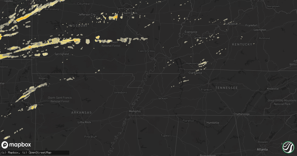
Hail Map in Kentucky on February 27, 2011
Get this storm
February 27 map
$229
one time, instant access
Download today. No call, no setup
Keep the $229
Bought the map and want the full workflow? Apply the entire $229 to a subscription within 7 days. None of it is wasted.
Every map, not just this one
This buys you this map. Subscription and you get every map we run, in the markets you choose from a few cities to whole states to nationwide. Plus real-time alerts the moment a storm fires.
Contact data
Name, contact info, occupancy, even credit band for addresses in the footprint. You go from where it hit to who to call.
Become the source they trust
Unlimited branding weather history reports on demand. You already have the documented answer ready for the property owner, and you are the one who showed up with it.
Property data and RoofTrace estimates
Pull up any address you have got, its value and the exact code rules for that jurisdiction, straight from One Click Code. Then RoofTrace estimates the squares, pitch, and roof value, priced the way you price.
Storm reports in Kentucky
Kentucky
| Date | Description |
|---|---|
| 02/27/20115:49 AM CST | An nws storm damage survey confirmed an ef-1 tornado with maximum wind speeds of 100 mph touched down about a mile southwest of stanford. The tornado traveled 8 miles b |
| 02/27/20115:46 AM CST | Numerous trees down and power lines and also some roofs blown off. |
| 02/27/20115:45 AM CST | The county road foreman reported several trees blocking roads countywide |
| 02/27/20115:20 AM CST | Barn damage and trees down. |
| 02/27/20115:16 AM CST | Tress down in the fincaslte area |
| 02/27/20115:05 AM CST | Part of a barn was damaged. |
| 02/27/20115:04 AM CST | A local report indicates 62 MPH wind near MAGNOLIA |
| 02/27/20114:34 AM CST | Trees and power lines down |
| 02/27/20114:15 AM CST | Several trees downed near falls of rough. Two downed trees blocked rolling stone acres lane and kiper-whitworth road. |
| 02/27/20114:13 AM CST | A local report indicates 1.00 inch wind near SYMSONIA |
| 02/27/20114:12 AM CST | A storm survey confirmed that straight line winds up to 65 mph destroyed a barn near polsgrove. A large tractor shed was destroyed on bates road near swallowfield. Seve |
| 02/27/20114:07 AM CST | Several trees down near the small town of flag fork. |
| 02/27/20114:00 AM CST | Power poles down across highway 22 |
| 02/27/20113:59 AM CST | *** 1 inj *** an nws storm damage survey confirmed an ef-3 tornado touched down at 459 am est 1.5 miles southeast of eminence and lifted 2 minutes later 3 miles east of |
| 02/27/20113:57 AM CST | Large tree fell on car on ellis road just south of the henry county line. Several other trees were downed in same location. |
| 02/27/20113:55 AM CST | Over 18 poles reported down. |
| 02/27/20113:54 AM CST | *** 3 inj *** house flattened along mulberry pike. |
| 02/27/20113:48 AM CST | Nws employee reported several trees down just north of anchorage. |
| 02/27/20113:39 AM CST | Trees were down along with power lines and a damaged power pole between crestwoood and ballardsville. |
| 02/27/20113:36 AM CST | Shed destroyed and trees down. |
| 02/27/20113:35 AM CST | Trees down four colums blown off a house... Windows blown out of a car. |
| 02/27/20113:33 AM CST | An ef-1 tornado with maximum wind speeds of 100 mph...width 100 yards. Tornado was continuation of utica in 2w tornado event lmk1100193. Tornado crossed ohio river and |
| 02/27/20113:32 AM CST | Trees down in the fincastle area |
| 02/27/20113:31 AM CST | Numerous trees downed. Funnel cloud. |
| 02/27/20113:15 AM CST | House trailer was damaged between smithland and tiline on dunlap road. |
All States Impacted by Hail Map on February 27, 2011
Cities Impacted by Hail Map on February 27, 2011
- Champaign, IL
- Howard, KS
- Eaton, OH
- Richmond, IN
- Higginsville, MO
- Stewart, TN
- Greenfield, MO
- Arcola, MO
- Lockwood, MO
- Goldthwaite, TX
- Hamilton, TX
- Frontenac, KS
- Pittsburg, KS
- East Saint Louis, IL
- Eureka, MO
- Pacific, MO
- Pleasant Hill, MO
- Harrisonville, MO
- Huntsville, MO
- Winchester, IN
- Greenview, IL
- Long Lane, MO
- Buffalo, MO
- Stuart, OK
- Climax Springs, MO
- Edwards, MO
- Wellsville, KS
- Ottawa, KS
- Edgerton, KS
- Boss, MO
- Bixby, MO
- Westville, OK
- Summers, AR
- Proctor, OK
- Nashoba, OK
- Yellville, AR
- Wichita, KS
- Winamac, IN
- Oblong, IL
- Willow Hill, IL
- West Liberty, IL
- Greenwood, IN
- Indianapolis, IN
- Green Valley, IL
- Ballwin, MO
- Chesterfield, MO
- Virgil, KS
- Fall River, KS
- Neal, KS
- Rosalia, KS
- Beaumont, KS
- Leon, KS
- Piedmont, KS
- Toronto, KS
- Severy, KS
- Eureka, KS
- La Grange, MO
- Harmony, IN
- Knightsville, IN
- Reelsville, IN
- Terre Haute, IN
- Cloverdale, IN
- Amo, IN
- Clayton, IN
- Greencastle, IN
- Carbon, IN
- Danville, IN
- Brazil, IN
- Fillmore, IN
- Rosedale, IN
- Coatesville, IN
- Putnamville, IN
- El Dorado, KS
- Cassoday, KS
- Burns, KS
- Princeton, IN
- Frost, TX
- Mcalester, OK
- Mount Sterling, MO
- Hermann, MO
- Linn, MO
- Bland, MO
- Owensville, MO
- Staunton, IL
- Valley Mills, TX
- Jonesboro, TX
- Gatesville, TX
- Mattoon, IL
- Lerna, IL
- Windsor, IL
- Gays, IL
- Cottonwood Falls, KS
- Elmdale, KS
- Gardner, KS
- Spring Hill, KS
- Shelbina, MO
- Deer Creek, OK
- Medford, OK
- Salem, MO
- West Salem, IL
- Avon, IN
- Brownsburg, IN
- Licking, MO
- Raymondville, MO
- Bowie, TX
- Montague, TX
- Meridian, TX
- Clifton, TX
- Petersburg, IL
- Cumby, TX
- Lone Oak, TX
- Brashear, TX
- Campbell, TX
- Benton, KS
- Valley Center, KS
- Centerville, KS
- Jerico Springs, MO
- Augusta, MO
- Coatsburg, IL
- Payson, IL
- Clayton, IL
- Paloma, IL
- Quincy, IL
- Camp Point, IL
- Fowler, IL
- Liberty, IL
- Palmyra, MO
- Lewisburg, OH
- Bolivar, MO
- Half Way, MO
- Bloomington, IL
- Italy, TX
- Milford, TX
- Sherman, TX
- Farmington, MO
- Ashmore, IL
- Charleston, IL
- Trilla, IL
- Neoga, IL
- Saint Louis, MO
- Columbus, KS
- Scammon, KS
- Mode, IL
- Cowden, IL
- Beecher City, IL
- Shelbyville, IL
- Colony, KS
- Westphalia, KS
- Stockton, MO
- Coffeyville, KS
- Dexter, KS
- Shidler, OK
- Maple City, KS
- Peru, KS
- Caney, KS
- Independence, KS
- Cedar Vale, KS
- Niotaze, KS
- Sedan, KS
- Havana, KS
- Lewistown, IL
- Lamar, MO
- Argonia, KS
- Washington, MO
- Labadie, MO
- Gray Summit, MO
- Union, MO
- Villa Ridge, MO
- Lincoln, IL
- New Holland, IL
- Stanford, IL
- Armstrong, MO
- Garnett, KS
- Salisbury, MO
- Bates City, MO
- Blackburn, MO
- Sweet Springs, MO
- Kingsville, MO
- Greenwood, MO
- Mayview, MO
- Freeman, MO
- Peculiar, MO
- Cleveland, MO
- Holden, MO
- Clifton Hill, MO
- Glasgow, MO
- Paola, KS
- Drexel, MO
- Concordia, MO
- Centerview, MO
- Higbee, MO
- Malta Bend, MO
- La Cygne, KS
- Warrensburg, MO
- Miami, MO
- Gilliam, MO
- Fontana, KS
- Raymore, MO
- Dalton, MO
- Greeley, KS
- Fayette, MO
- Parker, KS
- Marshall, MO
- Rantoul, KS
- Strasburg, MO
- Odessa, MO
- Lone Jack, MO
- Lane, KS
- Alma, MO
- Keytesville, MO
- Osawatomie, KS
- Slater, MO
- Richmond, KS
- Louisburg, KS
- Noblesville, IN
- Ashland, IL
- Tallula, IL
- Browning, IL
- Havana, IL
- Astoria, IL
- Rushville, IL
- Vermont, IL
- Kansas City, KS
- Clarksville, TN
- Mill Creek, OK
- Macomb, IL
- Cicero, IN
- Prairie Village, KS
- Madill, OK
- Delavan, IL
- Emden, IL
- Chrisman, IL
- Paris, IL
- Clinton, IN
- Milford Center, OH
- San Jose, IL
- Ipava, IL
- Rolla, MO
- Saint James, MO
- Welda, KS
- Le Roy, KS
- Neosho Falls, KS
- Kincaid, KS
- Girard, KS
- Cherokee, KS
- Liberal, MO
- Mindenmines, MO
- Arcanum, OH
- New Madison, OH
- Ellery, IL
- Albion, IL
- Park Hill, OK
- Vian, OK
- Bunch, OK
- Gore, OK
- Cookson, OK
- Stilwell, OK
- Elk Falls, KS
- Moline, KS
- Congerville, IL
- Antlers, OK
- Boswell, OK
- Rosebud, MO
- Cuba, MO
- Winchester, IL
- Lorena, TX
- Muskogee, OK
- Welling, OK
- Iola, KS
- Lebanon, MO
- Stoutland, MO
- Soper, OK
- Kemp, TX
- Loraine, IL
- Plymouth, IL
- Huntsville, IL
- Golden, IL
- Littleton, IL
- Augusta, IL
- Frederick, IL
- Camden, IL
- Timewell, IL
- La Prairie, IL
- Mendon, IL
- Mount Sterling, IL
- Bowen, IL
- Martinsville, IL
- Casey, IL
- Doe Run, MO
- Pocola, OK
- Arkoma, OK
- Fort Smith, AR
- Grandview, MO
- Kansas City, MO
- Belton, MO
- Midland, PA
- Negley, OH
- Darlington, PA
- East Liverpool, OH
- De Soto, KS
- Greenwich, KS
- Towanda, KS
- Colwich, KS
- Kechi, KS
- Garden Plain, KS
- Goddard, KS
- Maize, KS
- Potwin, KS
- Reeds, MO
- Sarcoxie, MO
- Joplin, MO
- Carthage, MO
- Webb City, MO
- Carterville, MO
- Sparta, IL
- Cutler, IL
- Coulterville, IL
- Boaz, KY
- Hickory, KY
- Symsonia, KY
- Union City, OH
- Greenville, OH
- Ansonia, OH
- Williamsburg, KS
- Waverly, KS
- Aline, OK
- Kenton, OH
- Stilesville, IN
- Burdick, KS
- Lincolnville, KS
- Madison, KS
- Whitney, TX
- Malone, TX
- Forreston, TX
- Itasca, TX
- Mertens, TX
- Abbott, TX
- Aquilla, TX
- Hillsboro, TX
- Penelope, TX
- Bynum, TX
- Shelbyville, MO
- Evant, TX
- McLean, IL
- Urbana, OH
- Russellville, KY
- Adairville, KY
- Hico, TX
- Alpena, AR
- Beaver, PA
- Rogers, OH
- Beaver Falls, PA
- Lisbon, OH
- Industry, PA
- Holliday, MO
- Lewisburg, KY
- Elkton, KY
- Atlanta, IL
- Elizabeth, IN
- Normal, IL
- Berger, MO
- New Haven, MO
- Sidney, OH
- Shirley, IL
- Dana, IN
- Ridge Farm, IL
- Cayuga, IN
- Fishers, IN
- Union City, IN
- Commercial Point, OH
- Orient, OH
- Marshall, IN
- Huntingdon, TN
- Braman, OK
- Goltry, OK
- Nash, OK
- Pond Creek, OK
- Jet, OK
- Crowley, TX
- Hardinsburg, KY
- Greenville, IL
- De Graff, OH
- Rensselaer, IN
- Lenox, MO
- Edgar Springs, MO
- Lampasas, TX
- Morgan, TX
- Lometa, TX
- Purmela, TX
- Star, TX
- Cranfills Gap, TX
- Dadeville, MO
- Aldrich, MO
- Lees Summit, MO
- Lentner, MO
- Excello, MO
- Cairo, MO
- Clarence, MO
- Macon, MO
- Jacksonville, MO
- Anabel, MO
- Nardin, OK
- Arkansas City, KS
- Blackwell, OK
- Newkirk, OK
- Stotts City, MO
- La Russell, MO
- Miller, MO
- Clay City, IN
- English, IN
- Bethalto, IL
- Moro, IL
- Edwardsville, IL
- Heyworth, IL
- Council Grove, KS
- Spiro, OK
- Cannelton, IN
- Cloverport, KY
- Winslow, IN
- Maplewood, OH
- Jackson Center, OH
- Anna, OH
- Marengo, OH
- Centerburg, OH
- Gerald, MO
- Geuda Springs, KS
- Valley View, TX
- Waverly, TN
- Erin, TN
- Tennessee Ridge, TN
- Virginia, IL
- Louisburg, MO
- Wapakoneta, OH
- Garland, KS
- Bronaugh, MO
- Dunnegan, MO
- Fair Play, MO
- Farmington, AR
- Fayetteville, AR
- Argos, IN
- Piqua, KS
- Yates Center, KS
- Tishomingo, OK
- Minier, IL
- Snow, OK
- Rattan, OK
- Mason City, IL
- Easton, IL
- Stringtown, OK
- Griggsville, IL
- Bluffs, IL
- Chambersburg, IL
- Meredosia, IL
- Neodesha, KS
- Erie, KS
- Dennis, KS
- Galesburg, KS
- Cherryvale, KS
- Thayer, KS
- Parsons, KS
- Saint Paul, KS
- Millstadt, IL
- Columbia, IL
- Saint Henry, OH
- Maria Stein, OH
- New Weston, OH
- North Salem, IN
- Ladoga, IN
- Jamestown, IN
- New Ross, IN
- Collinsville, TX
- Tioga, TX
- Atoka, OK
- Oakdale, IL
- Nashville, IL
- Pinckneyville, IL
- Westfield, IL
- Marshall, IL
- Kansas, IL
- Hopedale, IL
- Armington, IL
- Princeton, KS
- Edna, KS
- Baldwin City, KS
- Hamilton, KS
- Gridley, KS
- Peck, KS
- Haysville, KS
- Whitesboro, TX
- Gainesville, TX
- Chapin, IL
- Oswego, KS
- Kinta, OK
- Stigler, OK
- Rockbridge, OH
- Fairfield, IL
- Beardstown, IL
- Lamont, OK
- Elk City, KS
- Bartlett, KS
- Altamont, KS
- Longton, KS
- Liberty, KS
- Helena, OK
- Utica, KY
- Calhoun, KY
- Oronogo, MO
- McCune, KS
- Oglesby, TX
- McGregor, TX
- Osage City, KS
- Fair Grove, MO
- Garden City, MO
- Mays, IN
- Rushville, IN
- Knightstown, IN
- Lebanon, IN
- Madison, MO
- Warner, OK
- Webbers Falls, OK
- Kilbourne, IL
- Pembroke Township, IL
- Sheldon, MO
- Sunset, TX
- Lane, OK
- Richland, MO
- Windyville, MO
- Asbury, MO
- Flemington, MO
- Phillipsburg, MO
- Mound Valley, KS
- Golden City, MO
- Weir, KS
- Mulberry, KS
- Humansville, MO
- Elkland, MO
- Franklin, KS
- Tunas, MO
- Butler, IN
- Auburn, IN
- Industry, IL
- Lewis, IN
- Middle Brook, MO
- Bismarck, MO
- Ironton, MO
- Belleview, MO
- Avilla, MO
- Marion, KS
- Georgetown, IN
- Hartsburg, IL
- Mannsville, OK
- Ardmore, OK
- Lawrence, KS
- Winfield, KS
- Modoc, IN
- Losantville, IN
- Parker City, IN
- Bokoshe, OK
- Muldrow, OK
- Roland, OK
- Demotte, IN
- Wheatfield, IN
- Essex, IL
- Bonfield, IL
- Millersburg, OH
- Garfield, KY
- Harned, KY
- Irvington, KY
- Sunbury, OH
- Belle, MO
- Bluff City, KS
- New Paris, OH
- Depauw, IN
- Eldridge, MO
- Covington, IN
- Veedersburg, IN
- Adair, IL
- Tuscumbia, MO
- Niangua, MO
- Conway, MO
- Mccordsville, IN
- Greenfield, IN
- Albany, IN
- Muncie, IN
- Farmland, IN
- Selma, IN
- Mount Vernon, OH
- Bellville, OH
- Fredericktown, OH
- Butler, OH
- Hannibal, MO
- Celina, OH
- Delaware, OH
- Ashley, OH
- Ridgeville, IN
- Portland, IN
- Patoka, IN
- Clearwater, KS
- Wellington, KS
- Medaryville, IN
- North Judson, IN
- Whitewater, KS
- Andale, KS
- Calvin, OK
- Owensboro, KY
- Cambridge City, IN
- Greens Fork, IN
- Webster, KY
- Danvers, IL
- Trenton, KY
- Ivesdale, IL
- Mayfield, KY
- Cooksville, IL
- College Corner, OH
- Somerville, OH
- Camden, OH
- Westport, IN
- Sadler, TX
- Moundville, MO
- Hanson, KY
- Prairie Grove, AR
- Flora, IL
- Piqua, OH
- Simpson, IL
- Leslie, MO
- Beaufort, MO
- Lynn, IN
- Pomona, KS
- Quenemo, KS
- Melvern, KS
- Crofton, KY
- Kingman, KS
- Newton, KS
- Freeburg, MO
- La Harpe, KS
- Humboldt, KS
- Jacksonville, IL
- Honobia, OK
- Bath, IL
- Polk, MO
- Defiance, MO
- Sheridan, IN
- Westfield, IN
- Belleville, IL
- Freeburg, IL
- Mascoutah, IL
- Paris, MO
- Gravois Mills, MO
- Marysville, OH
- Vandalia, MO
- Roundhill, KY
- Brownsville, KY
- Hillsboro, IL
- Taylor Springs, IL
- Litchfield, IL
- Walshville, IL
- Irving, IL
- Witt, IL
- Reading, KS
- Lebo, KS
- Tahlequah, OK
- Springdale, AR
- Elkins, AR
- Lincoln, AR
- South Haven, KS
- Fredericktown, MO
- Park Hills, MO
- Matfield Green, KS
- Table Grove, IL
- Marietta, IL
- Topeka, IL
- Palestine, OH
- Hollansburg, OH
- Hermitage, MO
- New Castle, IN
- Mooreland, IN
- Monroe City, MO
- Maywood, MO
- Ursa, IL
- Taylor, MO
- Durant, OK
- Caddo, OK
- Maryland Heights, MO
- Carrollton, MO
- Nokomis, IL
- Pana, IL
- Oconee, IL
- Rosamond, IL
- Waxahachie, TX
- Midlothian, TX
- Croton, OH
- Pittsfield, IL
- Jeffersonville, IN
- Lewisville, IN
- Straughn, IN
- Eddy, TX
- Waco, TX
- Riesel, TX
- Bruceville, TX
- Marlin, TX
- Chilton, TX
- Crawford, TX
- Moody, TX
- Hewitt, TX
- Montezuma, IN
- Bloomingdale, IN
- Rockville, IN
- Russellville, IN
- Hillsdale, IN
- Krebs, OK
- Archie, MO
- Lewistown, OH
- Robertsville, MO
- Carl Junction, MO
- Anthony, KS
- Fortville, IN
- Alexandria, IN
- Groveport, OH
- Ashville, OH
- Canal Winchester, OH
- Shawnee, KS
- Fountain City, IN
- Kentland, IN
- Robinson, IL
- Palestine, IL
- Derby, KS
- Mayfield, KS
- Conway Springs, KS
- Milan, KS
- Mountain Grove, MO
- Hartville, MO
- Birdseye, IN
- Poland, IN
- Bowling Green, IN
- Urbana, IL
- Grenola, KS
- Plato, MO
- Waynesville, MO
- Duke, MO
- Fort Leonard Wood, MO
- Newburg, MO
- Burlington, KS
- Saint Paris, OH
- Houston, OH
- Russia, OH
- Koshkonong, MO
- West Plains, MO
- Reynolds Station, KY
- Fordsville, KY
- Bellefontaine, OH
- Cheney, KS
- Murdock, KS
- Mount Carmel, IL
- Fountaintown, IN
- Florence, KS
- Sedgwick, KS
- Reddick, IL
- Bowling Green, MO
- Middletown, MO
- Curryville, MO
- Anderson, IN
- Shirley, IN
- Hudson, IL
- Towanda, IL
- Hawesville, KY
- Mccurtain, OK
- Ashley, IL
- Du Bois, IL
- Russells Point, OH
- Quincy, OH
- Tyro, KS
- Norborne, MO
- Stonewall, OK
- Overland Park, KS
- Falcon, MO
- Jasper, MO
- Versailles, IL
- Augusta, KS
- Big Sandy, TN
- Wheatland, MO
- Lexington, MO
- Montezuma, OH
- Keota, OK
- Eckerty, IN
- Jacob, IL
- Perryville, MO
- Frohna, MO
- Gorham, IL
- Thorntown, IN
- Laura, OH
- Ludlow Falls, OH
- Pitsburg, OH
- Pottsboro, TX
- Denison, TX
- Pierceton, IN
- Warsaw, IN
- Marshfield, MO
- Roachdale, IN
- Saint Jo, TX
- Harrod, OH
- Alger, OH
- Peabody, KS
- Cedar Lake, IN
- New Bremen, OH
- Altamont, IL
- Fletcher, OH
- Emporia, KS
- Olpe, KS
- Huntsville, OH
- Chamois, MO
- Meta, MO
- Saint Elizabeth, MO
- Mound City, KS
- Pleasanton, KS
- Louisville, KY
- Simpsonville, KY
- Marengo, IN
- Fredonia, KS
- Mooresville, IN
- Bainbridge, IN
- Kopperl, TX
- Blum, TX
- Cumberland Furnace, TN
- Vanleer, TN
- Cumberland City, TN
- Highlandville, MO
- Urbana, MO
- Ennis, TX
- Middletown, IN
- Daleville, IN
- Saint Mary, MO
- Woodway, TX
- Laurel, IN
- Rockport, IL
- Munfordville, KY
- Wildwood, MO
- Saint Clair, MO
- Cartwright, OK
- Panama, IL
- Sorento, IL
- Huntsville, AR
- Hindsville, AR
- Danville, KY
- Stanford, KY
- Howe, TX
- Rose Hill, KS
- Ada, OH
- Churubusco, IN
- Albion, IN
- Versailles, OH
- Bradford, OH
- Covington, OH
- Brownstown, IL
- Saint Elmo, IL
- Strawn, IL
- Eudora, KS
- New Knoxville, OH
- Osceola, MO
- Quincy, MO
- Morganfield, KY
- Alton, MO
- Bruceton, TN
- Marthasville, MO
- Hepler, KS
- Uniontown, KS
- Guthrie, KY
- Allensville, KY
- Adams, TN
- Quinton, OK
- Hulbert, OK
- Centerpoint, IN
- Clark, MO
- Walnut, KS
- Manitou, KY
- Ellsworth, IL
- Pendleton, IN
- Jewett, IL
- Greenup, IL
- Fort Recovery, OH
- Coal City, IN
- Sainte Genevieve, MO
- Bunker, MO
- Seymour, MO
- Toledo, IL
- Macks Creek, MO
- Wellington, MO
- Spiceland, IN
- Dunkirk, OH
- Dola, OH
- Arcadia, KS
- Farlington, KS
- Arma, KS
- Woodburn, KY
- Hartford, KS
- Grant, OK
- Hugo, OK
- Williamsburg, IN
- Douglass, KS
- Caney, OK
- Newark, OH
- Granville, OH
- Gilman, IL
- Chatsworth, IL
- Onarga, IL
- Piper City, IL
- Stover, MO
- Lincoln, MO
- Ostrander, OH
- Botkins, OH
- Hartford, IL
- East Alton, IL
- Clarksville, IN
- Falls Of Rough, KY
- Moran, KS
- Heath, OH
- Loose Creek, MO
- New Albany, IN
- Maypearl, TX
- Venus, TX
- Moberly, MO
- Whitesville, KY
- Slaughters, KY
- Rumsey, KY
- Arenzville, IL
- Concord, IL
- New Salem, IL
- New Canton, IL
- Eldon, MO
- Shumway, IL
- Sigel, IL
- Stewardson, IL
- Rushsylvania, OH
- West Mansfield, OH
- Forest, OH
- Philpot, KY
- Conover, OH
- West Terre Haute, IN
- Springfield, KY
- Bardstown, KY
- Harrison, AR
- Lead Hill, AR
- Benton, KY
- Olmstead, KY
- Otwell, IN
- Borden, IN
- Greenville, IN
- Pekin, IN
- Palmyra, IN
- New Salisbury, IN
- Cross Timbers, MO
- Zanesville, OH
- Mount Perry, OH
- Roseville, OH
- Martinton, IL
- Bee Spring, KY
- Sweeden, KY
- Waverly, MO
- Ashkum, IL
- Danforth, IL
- Waveland, IN
- Crawfordsville, IN
- Rankin, IL
- Spivey, KS
- Ridgeway, OH
- Mount Victory, OH
- Coldwater, OH
- Stilwell, KS
- Grain Valley, MO
- Brunswick, MO
- Bucyrus, KS
- Oak Grove, MO
- West Liberty, OH
- Cable, OH
- Howard, OH
- Danville, OH
- Freeport, KS
- Clarkson, KY
- Clifton, IL
- Hagerstown, IN
- Economy, IN
- Corydon, IN
- Red Oak, TX
- Sullivan, MO
- Sparta, MO
- Downs, IL
- Le Roy, IL
- Beaverville, IL
- Saint Anne, IL
- Minster, OH
- Sharon Grove, KY
- Collins, MO
- Morocco, IN
- Lake Village, IN
- Killbuck, OH
- Glenmont, OH
- Yorktown, IN
- Willard, MO
- Walnut Grove, MO
- Morrisville, MO
- Petersburg, IN
- Tipp City, OH
- West Milton, OH
- Bourbonnais, IL
- Albers, IL
- Germantown, IL
- Emden, MO
- Monterey, IN
- Fort Worth, TX
- Galena, KS
- Wilkinson, IN
- Pawhuska, OK
- Checotah, OK
- Brook, IN
- Leawood, KS
- Knob Noster, MO
- Chetopa, KS
- Roundhead, OH
- Lakeview, OH
- Liberty, IN
- Saint Marys, OH
- Sugarcreek, OH
- Baltic, OH


