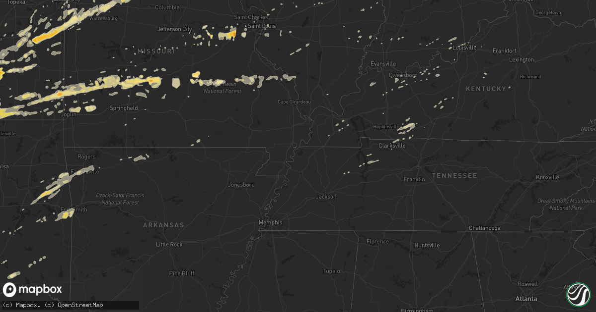
Hail Map in Kansas on February 27, 2011
Get this storm
February 27 map
$229
one time, instant access
Download today. No call, no setup
Keep the $229
Bought the map and want the full workflow? Apply the entire $229 to a subscription within 7 days. None of it is wasted.
Every map, not just this one
This buys you this map. Subscription and you get every map we run, in the markets you choose from a few cities to whole states to nationwide. Plus real-time alerts the moment a storm fires.
Contact data
Name, contact info, occupancy, even credit band for addresses in the footprint. You go from where it hit to who to call.
Become the source they trust
Unlimited branding weather history reports on demand. You already have the documented answer ready for the property owner, and you are the one who showed up with it.
Property data and RoofTrace estimates
Pull up any address you have got, its value and the exact code rules for that jurisdiction, straight from One Click Code. Then RoofTrace estimates the squares, pitch, and roof value, priced the way you price.
Storm reports in Kansas
Kansas
| Date | Description |
|---|---|
| 02/27/20115:55 PM CST | East side of town. |
| 02/27/20115:54 PM CST | Near the kansas oklahoma line. |
| 02/27/20115:20 PM CST | A local report indicates 1.00 inch wind near 3 NNW WEST WICHITA |
| 02/27/20115:19 PM CST | Off duty nws employee reported. |
| 02/27/20113:50 PM CST | A local report indicates 1.00 inch wind near 2 S LOUISBURG |
| 02/27/20113:42 PM CST | A few quarter sized with a lot of nickel sized. Relayed by olathe cwsu. |
| 02/27/20113:41 PM CST | A local report indicates 1.00 inch wind near OSAWATOMIE |
| 02/27/20113:40 PM CST | A local report indicates 1.75 inch wind near 2 S PAOLA |
| 02/27/20113:33 PM CST | A local report indicates 1.75 inch wind near LANE |
| 02/27/20113:22 PM CST | A local report indicates 1.75 inch wind near 2 E RICHMOND |
| 02/27/20113:22 PM CST | A local report indicates 1.75 inch wind near SSW RICHMOND |
| 02/27/20111:53 PM CST | On east douglas in wichita...power lines blown down. |
| 02/27/20111:45 PM CST | On east douglas in wichita...power lines blown down. Time corrected. |
| 02/27/20111:44 PM CST | Spotter estimates half inch to quarter sized hail at webb and pawnee. |
| 02/27/20111:23 PM CST | Kwch storm spotter reports quarter sized hail at 119th and kellogg. |
| 02/26/20119:55 PM CST | Quarter size hail reported by emergency management near us 160 and missouri - kansas border. |
| 02/26/20119:47 PM CST | A local report indicates 1.00 inch wind near FAULKNER |
| 02/26/20119:02 PM CST | A local report indicates 1.00 inch wind near 1 NNE CANEY |
| 02/26/20119:02 PM CST | Delayed report. |
| 02/26/20119:00 PM CST | A local report indicates 1.00 inch wind near 6 W IOLA |
| 02/26/20118:59 PM CST | Estimated 58-62 mph winds |
| 02/26/20118:58 PM CST | A local report indicates 1.00 inch wind near YATES CENTER |
| 02/26/20118:56 PM CST | A local report indicates 1.00 inch wind near CANEY |
| 02/26/20118:52 PM CST | Large trees uprooted in pittsburg kansas...also report of pea sized hail. |
| 02/26/20118:49 PM CST | A local report indicates 1.75 inch wind near PITTSBURG |
| 02/26/20118:44 PM CST | A local report indicates 1.75 inch wind near PITTSBURG |
| 02/26/20118:42 PM CST | A local report indicates 1.00 inch wind near TORONTO |
| 02/26/20118:42 PM CST | Correction for time. |
| 02/26/20118:39 PM CST | A local report indicates 1.75 inch wind near TORONTO |
| 02/26/20118:35 PM CST | A local report indicates 1.25 inch wind near HOWARD |
| 02/26/20118:35 PM CST | A local report indicates 1.00 inch wind near 2 E EUREKA |
| 02/26/20118:29 PM CST | A local report indicates 1.25 inch wind near 3 E EUREKA |
| 02/26/20118:28 PM CST | A local report indicates 1.00 inch wind near 5 S CEDAR VALE |
| 02/26/20118:24 PM CST | 5 power polls down in mccune kansas |
| 02/26/20117:42 PM CST | A local report indicates 1.00 inch wind near FRONTENAC |
| 02/26/20117:35 PM CST | Dime to quarter sized hail reported...corrected for mound city kansas |
| 02/26/20117:11 PM CST | A local report indicates 60 MPH wind near 6 SSW GARNETT |
| 02/26/20116:40 PM CST | West side of town. |
| 02/26/20116:23 PM CST | On the ground near the kansas/oklahoma border near k15. |
| 02/26/20116:23 PM CST | Crossing the kansas oklahoma state line. |
| 02/26/20116:23 PM CST | On the ground near the kansas/oklahoma border near k15. |
| 02/26/20116:20 PM CST | Reported by off duty nws employee chasing storm |
All States Impacted by Hail Map on February 27, 2011
Cities Impacted by Hail Map on February 27, 2011
- Champaign, IL
- Howard, KS
- Eaton, OH
- Richmond, IN
- Higginsville, MO
- Stewart, TN
- Greenfield, MO
- Arcola, MO
- Lockwood, MO
- Goldthwaite, TX
- Hamilton, TX
- Frontenac, KS
- Pittsburg, KS
- East Saint Louis, IL
- Eureka, MO
- Pacific, MO
- Pleasant Hill, MO
- Harrisonville, MO
- Huntsville, MO
- Winchester, IN
- Greenview, IL
- Long Lane, MO
- Buffalo, MO
- Stuart, OK
- Climax Springs, MO
- Edwards, MO
- Wellsville, KS
- Ottawa, KS
- Edgerton, KS
- Boss, MO
- Bixby, MO
- Westville, OK
- Summers, AR
- Proctor, OK
- Nashoba, OK
- Yellville, AR
- Wichita, KS
- Winamac, IN
- Oblong, IL
- Willow Hill, IL
- West Liberty, IL
- Greenwood, IN
- Indianapolis, IN
- Green Valley, IL
- Ballwin, MO
- Chesterfield, MO
- Virgil, KS
- Fall River, KS
- Neal, KS
- Rosalia, KS
- Beaumont, KS
- Leon, KS
- Piedmont, KS
- Toronto, KS
- Severy, KS
- Eureka, KS
- La Grange, MO
- Harmony, IN
- Knightsville, IN
- Reelsville, IN
- Terre Haute, IN
- Cloverdale, IN
- Amo, IN
- Clayton, IN
- Greencastle, IN
- Carbon, IN
- Danville, IN
- Brazil, IN
- Fillmore, IN
- Rosedale, IN
- Coatesville, IN
- Putnamville, IN
- El Dorado, KS
- Cassoday, KS
- Burns, KS
- Princeton, IN
- Frost, TX
- Mcalester, OK
- Mount Sterling, MO
- Hermann, MO
- Linn, MO
- Bland, MO
- Owensville, MO
- Staunton, IL
- Valley Mills, TX
- Jonesboro, TX
- Gatesville, TX
- Mattoon, IL
- Lerna, IL
- Windsor, IL
- Gays, IL
- Cottonwood Falls, KS
- Elmdale, KS
- Gardner, KS
- Spring Hill, KS
- Shelbina, MO
- Deer Creek, OK
- Medford, OK
- Salem, MO
- West Salem, IL
- Avon, IN
- Brownsburg, IN
- Licking, MO
- Raymondville, MO
- Bowie, TX
- Montague, TX
- Meridian, TX
- Clifton, TX
- Petersburg, IL
- Cumby, TX
- Lone Oak, TX
- Brashear, TX
- Campbell, TX
- Benton, KS
- Valley Center, KS
- Centerville, KS
- Jerico Springs, MO
- Augusta, MO
- Coatsburg, IL
- Payson, IL
- Clayton, IL
- Paloma, IL
- Quincy, IL
- Camp Point, IL
- Fowler, IL
- Liberty, IL
- Palmyra, MO
- Lewisburg, OH
- Bolivar, MO
- Half Way, MO
- Bloomington, IL
- Italy, TX
- Milford, TX
- Sherman, TX
- Farmington, MO
- Ashmore, IL
- Charleston, IL
- Trilla, IL
- Neoga, IL
- Saint Louis, MO
- Columbus, KS
- Scammon, KS
- Mode, IL
- Cowden, IL
- Beecher City, IL
- Shelbyville, IL
- Colony, KS
- Westphalia, KS
- Stockton, MO
- Coffeyville, KS
- Dexter, KS
- Shidler, OK
- Maple City, KS
- Peru, KS
- Caney, KS
- Independence, KS
- Cedar Vale, KS
- Niotaze, KS
- Sedan, KS
- Havana, KS
- Lewistown, IL
- Lamar, MO
- Argonia, KS
- Washington, MO
- Labadie, MO
- Gray Summit, MO
- Union, MO
- Villa Ridge, MO
- Lincoln, IL
- New Holland, IL
- Stanford, IL
- Armstrong, MO
- Garnett, KS
- Salisbury, MO
- Bates City, MO
- Blackburn, MO
- Sweet Springs, MO
- Kingsville, MO
- Greenwood, MO
- Mayview, MO
- Freeman, MO
- Peculiar, MO
- Cleveland, MO
- Holden, MO
- Clifton Hill, MO
- Glasgow, MO
- Paola, KS
- Drexel, MO
- Concordia, MO
- Centerview, MO
- Higbee, MO
- Malta Bend, MO
- La Cygne, KS
- Warrensburg, MO
- Miami, MO
- Gilliam, MO
- Fontana, KS
- Raymore, MO
- Dalton, MO
- Greeley, KS
- Fayette, MO
- Parker, KS
- Marshall, MO
- Rantoul, KS
- Strasburg, MO
- Odessa, MO
- Lone Jack, MO
- Lane, KS
- Alma, MO
- Keytesville, MO
- Osawatomie, KS
- Slater, MO
- Richmond, KS
- Louisburg, KS
- Noblesville, IN
- Ashland, IL
- Tallula, IL
- Browning, IL
- Havana, IL
- Astoria, IL
- Rushville, IL
- Vermont, IL
- Kansas City, KS
- Clarksville, TN
- Mill Creek, OK
- Macomb, IL
- Cicero, IN
- Prairie Village, KS
- Madill, OK
- Delavan, IL
- Emden, IL
- Chrisman, IL
- Paris, IL
- Clinton, IN
- Milford Center, OH
- San Jose, IL
- Ipava, IL
- Rolla, MO
- Saint James, MO
- Welda, KS
- Le Roy, KS
- Neosho Falls, KS
- Kincaid, KS
- Girard, KS
- Cherokee, KS
- Liberal, MO
- Mindenmines, MO
- Arcanum, OH
- New Madison, OH
- Ellery, IL
- Albion, IL
- Park Hill, OK
- Vian, OK
- Bunch, OK
- Gore, OK
- Cookson, OK
- Stilwell, OK
- Elk Falls, KS
- Moline, KS
- Congerville, IL
- Antlers, OK
- Boswell, OK
- Rosebud, MO
- Cuba, MO
- Winchester, IL
- Lorena, TX
- Muskogee, OK
- Welling, OK
- Iola, KS
- Lebanon, MO
- Stoutland, MO
- Soper, OK
- Kemp, TX
- Loraine, IL
- Plymouth, IL
- Huntsville, IL
- Golden, IL
- Littleton, IL
- Augusta, IL
- Frederick, IL
- Camden, IL
- Timewell, IL
- La Prairie, IL
- Mendon, IL
- Mount Sterling, IL
- Bowen, IL
- Martinsville, IL
- Casey, IL
- Doe Run, MO
- Pocola, OK
- Arkoma, OK
- Fort Smith, AR
- Grandview, MO
- Kansas City, MO
- Belton, MO
- Midland, PA
- Negley, OH
- Darlington, PA
- East Liverpool, OH
- De Soto, KS
- Greenwich, KS
- Towanda, KS
- Colwich, KS
- Kechi, KS
- Garden Plain, KS
- Goddard, KS
- Maize, KS
- Potwin, KS
- Reeds, MO
- Sarcoxie, MO
- Joplin, MO
- Carthage, MO
- Webb City, MO
- Carterville, MO
- Sparta, IL
- Cutler, IL
- Coulterville, IL
- Boaz, KY
- Hickory, KY
- Symsonia, KY
- Union City, OH
- Greenville, OH
- Ansonia, OH
- Williamsburg, KS
- Waverly, KS
- Aline, OK
- Kenton, OH
- Stilesville, IN
- Burdick, KS
- Lincolnville, KS
- Madison, KS
- Whitney, TX
- Malone, TX
- Forreston, TX
- Itasca, TX
- Mertens, TX
- Abbott, TX
- Aquilla, TX
- Hillsboro, TX
- Penelope, TX
- Bynum, TX
- Shelbyville, MO
- Evant, TX
- McLean, IL
- Urbana, OH
- Russellville, KY
- Adairville, KY
- Hico, TX
- Alpena, AR
- Beaver, PA
- Rogers, OH
- Beaver Falls, PA
- Lisbon, OH
- Industry, PA
- Holliday, MO
- Lewisburg, KY
- Elkton, KY
- Atlanta, IL
- Elizabeth, IN
- Normal, IL
- Berger, MO
- New Haven, MO
- Sidney, OH
- Shirley, IL
- Dana, IN
- Ridge Farm, IL
- Cayuga, IN
- Fishers, IN
- Union City, IN
- Commercial Point, OH
- Orient, OH
- Marshall, IN
- Huntingdon, TN
- Braman, OK
- Goltry, OK
- Nash, OK
- Pond Creek, OK
- Jet, OK
- Crowley, TX
- Hardinsburg, KY
- Greenville, IL
- De Graff, OH
- Rensselaer, IN
- Lenox, MO
- Edgar Springs, MO
- Lampasas, TX
- Morgan, TX
- Lometa, TX
- Purmela, TX
- Star, TX
- Cranfills Gap, TX
- Dadeville, MO
- Aldrich, MO
- Lees Summit, MO
- Lentner, MO
- Excello, MO
- Cairo, MO
- Clarence, MO
- Macon, MO
- Jacksonville, MO
- Anabel, MO
- Nardin, OK
- Arkansas City, KS
- Blackwell, OK
- Newkirk, OK
- Stotts City, MO
- La Russell, MO
- Miller, MO
- Clay City, IN
- English, IN
- Bethalto, IL
- Moro, IL
- Edwardsville, IL
- Heyworth, IL
- Council Grove, KS
- Spiro, OK
- Cannelton, IN
- Cloverport, KY
- Winslow, IN
- Maplewood, OH
- Jackson Center, OH
- Anna, OH
- Marengo, OH
- Centerburg, OH
- Gerald, MO
- Geuda Springs, KS
- Valley View, TX
- Waverly, TN
- Erin, TN
- Tennessee Ridge, TN
- Virginia, IL
- Louisburg, MO
- Wapakoneta, OH
- Garland, KS
- Bronaugh, MO
- Dunnegan, MO
- Fair Play, MO
- Farmington, AR
- Fayetteville, AR
- Argos, IN
- Piqua, KS
- Yates Center, KS
- Tishomingo, OK
- Minier, IL
- Snow, OK
- Rattan, OK
- Mason City, IL
- Easton, IL
- Stringtown, OK
- Griggsville, IL
- Bluffs, IL
- Chambersburg, IL
- Meredosia, IL
- Neodesha, KS
- Erie, KS
- Dennis, KS
- Galesburg, KS
- Cherryvale, KS
- Thayer, KS
- Parsons, KS
- Saint Paul, KS
- Millstadt, IL
- Columbia, IL
- Saint Henry, OH
- Maria Stein, OH
- New Weston, OH
- North Salem, IN
- Ladoga, IN
- Jamestown, IN
- New Ross, IN
- Collinsville, TX
- Tioga, TX
- Atoka, OK
- Oakdale, IL
- Nashville, IL
- Pinckneyville, IL
- Westfield, IL
- Marshall, IL
- Kansas, IL
- Hopedale, IL
- Armington, IL
- Princeton, KS
- Edna, KS
- Baldwin City, KS
- Hamilton, KS
- Gridley, KS
- Peck, KS
- Haysville, KS
- Whitesboro, TX
- Gainesville, TX
- Chapin, IL
- Oswego, KS
- Kinta, OK
- Stigler, OK
- Rockbridge, OH
- Fairfield, IL
- Beardstown, IL
- Lamont, OK
- Elk City, KS
- Bartlett, KS
- Altamont, KS
- Longton, KS
- Liberty, KS
- Helena, OK
- Utica, KY
- Calhoun, KY
- Oronogo, MO
- McCune, KS
- Oglesby, TX
- McGregor, TX
- Osage City, KS
- Fair Grove, MO
- Garden City, MO
- Mays, IN
- Rushville, IN
- Knightstown, IN
- Lebanon, IN
- Madison, MO
- Warner, OK
- Webbers Falls, OK
- Kilbourne, IL
- Pembroke Township, IL
- Sheldon, MO
- Sunset, TX
- Lane, OK
- Richland, MO
- Windyville, MO
- Asbury, MO
- Flemington, MO
- Phillipsburg, MO
- Mound Valley, KS
- Golden City, MO
- Weir, KS
- Mulberry, KS
- Humansville, MO
- Elkland, MO
- Franklin, KS
- Tunas, MO
- Butler, IN
- Auburn, IN
- Industry, IL
- Lewis, IN
- Middle Brook, MO
- Bismarck, MO
- Ironton, MO
- Belleview, MO
- Avilla, MO
- Marion, KS
- Georgetown, IN
- Hartsburg, IL
- Mannsville, OK
- Ardmore, OK
- Lawrence, KS
- Winfield, KS
- Modoc, IN
- Losantville, IN
- Parker City, IN
- Bokoshe, OK
- Muldrow, OK
- Roland, OK
- Demotte, IN
- Wheatfield, IN
- Essex, IL
- Bonfield, IL
- Millersburg, OH
- Garfield, KY
- Harned, KY
- Irvington, KY
- Sunbury, OH
- Belle, MO
- Bluff City, KS
- New Paris, OH
- Depauw, IN
- Eldridge, MO
- Covington, IN
- Veedersburg, IN
- Adair, IL
- Tuscumbia, MO
- Niangua, MO
- Conway, MO
- Mccordsville, IN
- Greenfield, IN
- Albany, IN
- Muncie, IN
- Farmland, IN
- Selma, IN
- Mount Vernon, OH
- Bellville, OH
- Fredericktown, OH
- Butler, OH
- Hannibal, MO
- Celina, OH
- Delaware, OH
- Ashley, OH
- Ridgeville, IN
- Portland, IN
- Patoka, IN
- Clearwater, KS
- Wellington, KS
- Medaryville, IN
- North Judson, IN
- Whitewater, KS
- Andale, KS
- Calvin, OK
- Owensboro, KY
- Cambridge City, IN
- Greens Fork, IN
- Webster, KY
- Danvers, IL
- Trenton, KY
- Ivesdale, IL
- Mayfield, KY
- Cooksville, IL
- College Corner, OH
- Somerville, OH
- Camden, OH
- Westport, IN
- Sadler, TX
- Moundville, MO
- Hanson, KY
- Prairie Grove, AR
- Flora, IL
- Piqua, OH
- Simpson, IL
- Leslie, MO
- Beaufort, MO
- Lynn, IN
- Pomona, KS
- Quenemo, KS
- Melvern, KS
- Crofton, KY
- Kingman, KS
- Newton, KS
- Freeburg, MO
- La Harpe, KS
- Humboldt, KS
- Jacksonville, IL
- Honobia, OK
- Bath, IL
- Polk, MO
- Defiance, MO
- Sheridan, IN
- Westfield, IN
- Belleville, IL
- Freeburg, IL
- Mascoutah, IL
- Paris, MO
- Gravois Mills, MO
- Marysville, OH
- Vandalia, MO
- Roundhill, KY
- Brownsville, KY
- Hillsboro, IL
- Taylor Springs, IL
- Litchfield, IL
- Walshville, IL
- Irving, IL
- Witt, IL
- Reading, KS
- Lebo, KS
- Tahlequah, OK
- Springdale, AR
- Elkins, AR
- Lincoln, AR
- South Haven, KS
- Fredericktown, MO
- Park Hills, MO
- Matfield Green, KS
- Table Grove, IL
- Marietta, IL
- Topeka, IL
- Palestine, OH
- Hollansburg, OH
- Hermitage, MO
- New Castle, IN
- Mooreland, IN
- Monroe City, MO
- Maywood, MO
- Ursa, IL
- Taylor, MO
- Durant, OK
- Caddo, OK
- Maryland Heights, MO
- Carrollton, MO
- Nokomis, IL
- Pana, IL
- Oconee, IL
- Rosamond, IL
- Waxahachie, TX
- Midlothian, TX
- Croton, OH
- Pittsfield, IL
- Jeffersonville, IN
- Lewisville, IN
- Straughn, IN
- Eddy, TX
- Waco, TX
- Riesel, TX
- Bruceville, TX
- Marlin, TX
- Chilton, TX
- Crawford, TX
- Moody, TX
- Hewitt, TX
- Montezuma, IN
- Bloomingdale, IN
- Rockville, IN
- Russellville, IN
- Hillsdale, IN
- Krebs, OK
- Archie, MO
- Lewistown, OH
- Robertsville, MO
- Carl Junction, MO
- Anthony, KS
- Fortville, IN
- Alexandria, IN
- Groveport, OH
- Ashville, OH
- Canal Winchester, OH
- Shawnee, KS
- Fountain City, IN
- Kentland, IN
- Robinson, IL
- Palestine, IL
- Derby, KS
- Mayfield, KS
- Conway Springs, KS
- Milan, KS
- Mountain Grove, MO
- Hartville, MO
- Birdseye, IN
- Poland, IN
- Bowling Green, IN
- Urbana, IL
- Grenola, KS
- Plato, MO
- Waynesville, MO
- Duke, MO
- Fort Leonard Wood, MO
- Newburg, MO
- Burlington, KS
- Saint Paris, OH
- Houston, OH
- Russia, OH
- Koshkonong, MO
- West Plains, MO
- Reynolds Station, KY
- Fordsville, KY
- Bellefontaine, OH
- Cheney, KS
- Murdock, KS
- Mount Carmel, IL
- Fountaintown, IN
- Florence, KS
- Sedgwick, KS
- Reddick, IL
- Bowling Green, MO
- Middletown, MO
- Curryville, MO
- Anderson, IN
- Shirley, IN
- Hudson, IL
- Towanda, IL
- Hawesville, KY
- Mccurtain, OK
- Ashley, IL
- Du Bois, IL
- Russells Point, OH
- Quincy, OH
- Tyro, KS
- Norborne, MO
- Stonewall, OK
- Overland Park, KS
- Falcon, MO
- Jasper, MO
- Versailles, IL
- Augusta, KS
- Big Sandy, TN
- Wheatland, MO
- Lexington, MO
- Montezuma, OH
- Keota, OK
- Eckerty, IN
- Jacob, IL
- Perryville, MO
- Frohna, MO
- Gorham, IL
- Thorntown, IN
- Laura, OH
- Ludlow Falls, OH
- Pitsburg, OH
- Pottsboro, TX
- Denison, TX
- Pierceton, IN
- Warsaw, IN
- Marshfield, MO
- Roachdale, IN
- Saint Jo, TX
- Harrod, OH
- Alger, OH
- Peabody, KS
- Cedar Lake, IN
- New Bremen, OH
- Altamont, IL
- Fletcher, OH
- Emporia, KS
- Olpe, KS
- Huntsville, OH
- Chamois, MO
- Meta, MO
- Saint Elizabeth, MO
- Mound City, KS
- Pleasanton, KS
- Louisville, KY
- Simpsonville, KY
- Marengo, IN
- Fredonia, KS
- Mooresville, IN
- Bainbridge, IN
- Kopperl, TX
- Blum, TX
- Cumberland Furnace, TN
- Vanleer, TN
- Cumberland City, TN
- Highlandville, MO
- Urbana, MO
- Ennis, TX
- Middletown, IN
- Daleville, IN
- Saint Mary, MO
- Woodway, TX
- Laurel, IN
- Rockport, IL
- Munfordville, KY
- Wildwood, MO
- Saint Clair, MO
- Cartwright, OK
- Panama, IL
- Sorento, IL
- Huntsville, AR
- Hindsville, AR
- Danville, KY
- Stanford, KY
- Howe, TX
- Rose Hill, KS
- Ada, OH
- Churubusco, IN
- Albion, IN
- Versailles, OH
- Bradford, OH
- Covington, OH
- Brownstown, IL
- Saint Elmo, IL
- Strawn, IL
- Eudora, KS
- New Knoxville, OH
- Osceola, MO
- Quincy, MO
- Morganfield, KY
- Alton, MO
- Bruceton, TN
- Marthasville, MO
- Hepler, KS
- Uniontown, KS
- Guthrie, KY
- Allensville, KY
- Adams, TN
- Quinton, OK
- Hulbert, OK
- Centerpoint, IN
- Clark, MO
- Walnut, KS
- Manitou, KY
- Ellsworth, IL
- Pendleton, IN
- Jewett, IL
- Greenup, IL
- Fort Recovery, OH
- Coal City, IN
- Sainte Genevieve, MO
- Bunker, MO
- Seymour, MO
- Toledo, IL
- Macks Creek, MO
- Wellington, MO
- Spiceland, IN
- Dunkirk, OH
- Dola, OH
- Arcadia, KS
- Farlington, KS
- Arma, KS
- Woodburn, KY
- Hartford, KS
- Grant, OK
- Hugo, OK
- Williamsburg, IN
- Douglass, KS
- Caney, OK
- Newark, OH
- Granville, OH
- Gilman, IL
- Chatsworth, IL
- Onarga, IL
- Piper City, IL
- Stover, MO
- Lincoln, MO
- Ostrander, OH
- Botkins, OH
- Hartford, IL
- East Alton, IL
- Clarksville, IN
- Falls Of Rough, KY
- Moran, KS
- Heath, OH
- Loose Creek, MO
- New Albany, IN
- Maypearl, TX
- Venus, TX
- Moberly, MO
- Whitesville, KY
- Slaughters, KY
- Rumsey, KY
- Arenzville, IL
- Concord, IL
- New Salem, IL
- New Canton, IL
- Eldon, MO
- Shumway, IL
- Sigel, IL
- Stewardson, IL
- Rushsylvania, OH
- West Mansfield, OH
- Forest, OH
- Philpot, KY
- Conover, OH
- West Terre Haute, IN
- Springfield, KY
- Bardstown, KY
- Harrison, AR
- Lead Hill, AR
- Benton, KY
- Olmstead, KY
- Otwell, IN
- Borden, IN
- Greenville, IN
- Pekin, IN
- Palmyra, IN
- New Salisbury, IN
- Cross Timbers, MO
- Zanesville, OH
- Mount Perry, OH
- Roseville, OH
- Martinton, IL
- Bee Spring, KY
- Sweeden, KY
- Waverly, MO
- Ashkum, IL
- Danforth, IL
- Waveland, IN
- Crawfordsville, IN
- Rankin, IL
- Spivey, KS
- Ridgeway, OH
- Mount Victory, OH
- Coldwater, OH
- Stilwell, KS
- Grain Valley, MO
- Brunswick, MO
- Bucyrus, KS
- Oak Grove, MO
- West Liberty, OH
- Cable, OH
- Howard, OH
- Danville, OH
- Freeport, KS
- Clarkson, KY
- Clifton, IL
- Hagerstown, IN
- Economy, IN
- Corydon, IN
- Red Oak, TX
- Sullivan, MO
- Sparta, MO
- Downs, IL
- Le Roy, IL
- Beaverville, IL
- Saint Anne, IL
- Minster, OH
- Sharon Grove, KY
- Collins, MO
- Morocco, IN
- Lake Village, IN
- Killbuck, OH
- Glenmont, OH
- Yorktown, IN
- Willard, MO
- Walnut Grove, MO
- Morrisville, MO
- Petersburg, IN
- Tipp City, OH
- West Milton, OH
- Bourbonnais, IL
- Albers, IL
- Germantown, IL
- Emden, MO
- Monterey, IN
- Fort Worth, TX
- Galena, KS
- Wilkinson, IN
- Pawhuska, OK
- Checotah, OK
- Brook, IN
- Leawood, KS
- Knob Noster, MO
- Chetopa, KS
- Roundhead, OH
- Lakeview, OH
- Liberty, IN
- Saint Marys, OH
- Sugarcreek, OH
- Baltic, OH


