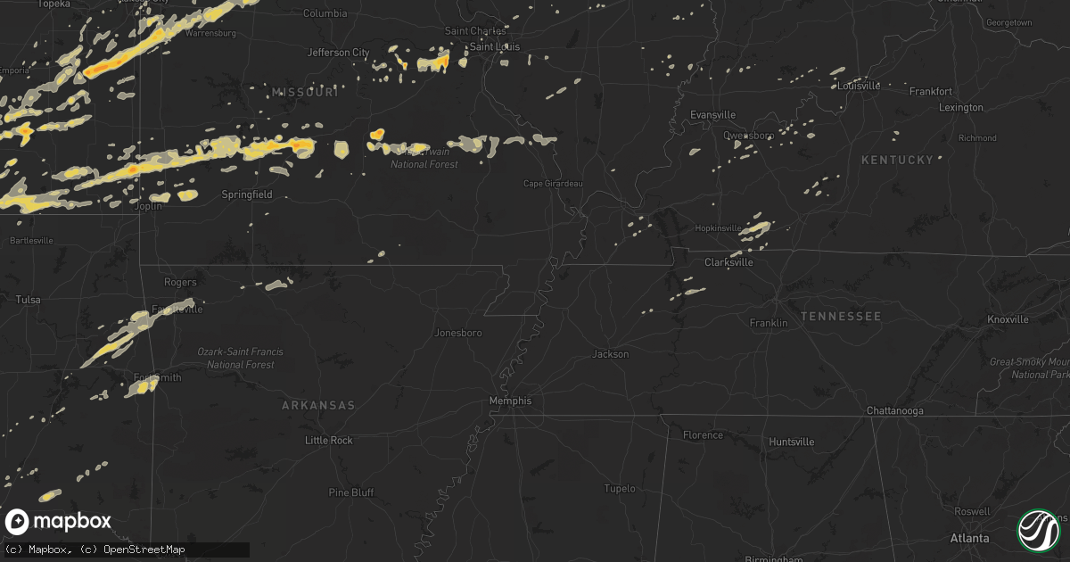
Hail Map on February 27, 2011
Get this storm
February 27 map
$229
one time, instant access
Download today. No call, no setup
Keep the $229
Bought the map and want the full workflow? Apply the entire $229 to a subscription within 7 days. None of it is wasted.
Every map, not just this one
This buys you this map. Subscription and you get every map we run, in the markets you choose from a few cities to whole states to nationwide. Plus real-time alerts the moment a storm fires.
Contact data
Name, contact info, occupancy, even credit band for addresses in the footprint. You go from where it hit to who to call.
Become the source they trust
Unlimited branding weather history reports on demand. You already have the documented answer ready for the property owner, and you are the one who showed up with it.
Property data and RoofTrace estimates
Pull up any address you have got, its value and the exact code rules for that jurisdiction, straight from One Click Code. Then RoofTrace estimates the squares, pitch, and roof value, priced the way you price.
States Impacted by Hail Map on February 27, 2011
Storm reports
Kentucky
| Date | Description |
|---|---|
| 02/27/20115:49 AM CST | An nws storm damage survey confirmed an ef-1 tornado with maximum wind speeds of 100 mph touched down about a mile southwest of stanford. The tornado traveled 8 miles b |
| 02/27/20115:46 AM CST | Numerous trees down and power lines and also some roofs blown off. |
| 02/27/20115:45 AM CST | The county road foreman reported several trees blocking roads countywide |
| 02/27/20115:20 AM CST | Barn damage and trees down. |
| 02/27/20115:16 AM CST | Tress down in the fincaslte area |
| 02/27/20115:05 AM CST | Part of a barn was damaged. |
| 02/27/20115:04 AM CST | A local report indicates 62 MPH wind near MAGNOLIA |
| 02/27/20114:34 AM CST | Trees and power lines down |
| 02/27/20114:15 AM CST | Several trees downed near falls of rough. Two downed trees blocked rolling stone acres lane and kiper-whitworth road. |
| 02/27/20114:13 AM CST | A local report indicates 1.00 inch wind near SYMSONIA |
| 02/27/20114:12 AM CST | A storm survey confirmed that straight line winds up to 65 mph destroyed a barn near polsgrove. A large tractor shed was destroyed on bates road near swallowfield. Seve |
| 02/27/20114:07 AM CST | Several trees down near the small town of flag fork. |
| 02/27/20114:00 AM CST | Power poles down across highway 22 |
| 02/27/20113:59 AM CST | *** 1 inj *** an nws storm damage survey confirmed an ef-3 tornado touched down at 459 am est 1.5 miles southeast of eminence and lifted 2 minutes later 3 miles east of |
| 02/27/20113:57 AM CST | Large tree fell on car on ellis road just south of the henry county line. Several other trees were downed in same location. |
| 02/27/20113:55 AM CST | Over 18 poles reported down. |
| 02/27/20113:54 AM CST | *** 3 inj *** house flattened along mulberry pike. |
| 02/27/20113:48 AM CST | Nws employee reported several trees down just north of anchorage. |
| 02/27/20113:39 AM CST | Trees were down along with power lines and a damaged power pole between crestwoood and ballardsville. |
| 02/27/20113:36 AM CST | Shed destroyed and trees down. |
| 02/27/20113:35 AM CST | Trees down four colums blown off a house... Windows blown out of a car. |
| 02/27/20113:33 AM CST | An ef-1 tornado with maximum wind speeds of 100 mph...width 100 yards. Tornado was continuation of utica in 2w tornado event lmk1100193. Tornado crossed ohio river and |
| 02/27/20113:32 AM CST | Trees down in the fincastle area |
| 02/27/20113:31 AM CST | Numerous trees downed. Funnel cloud. |
| 02/27/20113:15 AM CST | House trailer was damaged between smithland and tiline on dunlap road. |
Indiana
| Date | Description |
|---|---|
| 02/27/20114:59 AM CST | Trees and power lines down |
| 02/27/20113:45 AM CST | Many shingles torn off a roof from the high winds. |
| 02/27/20113:31 AM CST | An nws storm damage survey confirmed an ef-1 tornado with maximum wind speeds of 95 to 100 mph touched down 2 miles west of utica indiana...crossed the ohio river...and |
| 02/27/20113:29 AM CST | An nws storm damage survey confirmed an ef-1 tornado with maximum wind speeds of 95 to 100 mph touched down 2 miles west of utica indiana...crossed the ohio river...and |
| 02/27/20113:27 AM CST | Trees and power lines down along with power outages. |
| 02/27/20113:26 AM CST | Power outages reported in jeffersonville. |
| 02/27/20113:22 AM CST | Roof damage to a wal-mart in new albany. |
| 02/27/20113:10 AM CST | Trees down. Time estimated. |
| 02/27/20113:05 AM CST | Three modular homes with roof damage. |
| 02/27/20112:54 AM CST | A local report indicates 65 MPH wind near CURBY |
| 02/27/20112:50 AM CST | State road 66 south of marengo is closed due to power lines down on the road. |
| 02/27/20112:48 AM CST | Dime size hail also reported. |
| 02/27/20112:46 AM CST | Straight line wind damage at 3 separate points just north of valeene. About 2 miles northwest of valeene...an outbuilding was destroyed and a large cedar tree was uproo |
| 02/27/20112:32 AM CST | 4-5 homes damaged or destroyed in ellsworth. Several injuries. |
| 02/27/20112:27 AM CST | Power outages in jasper. Reported by wave and weht. |
| 02/27/20112:27 AM CST | Roof blown off of a house. |
| 02/27/20112:23 AM CST | A local report indicates 65 MPH wind near IRELAND |
| 02/27/20112:19 AM CST | *** 1 inj *** an nws storm damage survey confirmed that an ef-1 tornado touched down about 5.5 miles southwest of jasper damaging several large metal buildings...a larg |
| 02/27/20112:18 AM CST | Viewer reported roof of home blown off. |
| 02/27/20112:18 AM CST | Numerous reports of damage in community and in the southern princeton area. Owensville fire dept is requesting gas company due to several homes damage and check the are |
| 02/27/20112:17 AM CST | 40 to 50 inch diameter pine trees down. |
| 02/27/20112:10 AM CST | An ef0 tornado touched down 2.5 miles southwest of otwell and traveled east for 2 miles to 1 mile south of otwell. Average path width was 150 yards. Peak wind was 85 mp |
| 02/27/20112:05 AM CST | Power lines down. |
| 02/27/20112:03 AM CST | Quarter size hail reported west of town. |
| 02/27/20112:00 AM CST | Numerous power outages. Multiple trees down. Roof blown off of brick building taking down large section of power lines. |
| 02/27/20111:59 AM CST | 14 inch diameter tree down. Community is without power. |
| 02/27/20111:58 AM CST | Multiple homes damaged north and east of the community. |
| 02/27/20111:51 AM CST | An ef2 tornado touched down 2 miles southeast of princeton and travelled east for 19 and a quarter miles to 2 miles west of velpen by 209 am. Peak wind was 115 mph. Ave |
| 02/27/20111:43 AM CST | An ef1 tornado touched down 6 miles west of owensville and traveled east for 22 miles to one half mile east of somerville by 204 am. Peak wind was 105 mph...and the pat |
| 02/27/201112:30 AM CST | Evergreens /40 to 50 foot tall/ knocked over near us 31 and state road 22. |
| 02/27/201112:20 AM CST | House destroyed as a couple of walls were knocked down. |
| 02/27/201112:00 AM CST | Roof blown off of house. |
| 02/26/201111:35 PM CST | Nws damage survey confirms tornado starting near county road 1050s and ending just north of county road 1000s. Path length just over one half mile and path width near 2 |
| 02/26/201110:40 PM CST | Nickel to quarter size hail and gusty winds |
Kansas
| Date | Description |
|---|---|
| 02/27/20115:55 PM CST | East side of town. |
| 02/27/20115:54 PM CST | Near the kansas oklahoma line. |
| 02/27/20115:20 PM CST | A local report indicates 1.00 inch wind near 3 NNW WEST WICHITA |
| 02/27/20115:19 PM CST | Off duty nws employee reported. |
| 02/27/20113:50 PM CST | A local report indicates 1.00 inch wind near 2 S LOUISBURG |
| 02/27/20113:42 PM CST | A few quarter sized with a lot of nickel sized. Relayed by olathe cwsu. |
| 02/27/20113:41 PM CST | A local report indicates 1.00 inch wind near OSAWATOMIE |
| 02/27/20113:40 PM CST | A local report indicates 1.75 inch wind near 2 S PAOLA |
| 02/27/20113:33 PM CST | A local report indicates 1.75 inch wind near LANE |
| 02/27/20113:22 PM CST | A local report indicates 1.75 inch wind near SSW RICHMOND |
| 02/27/20113:22 PM CST | A local report indicates 1.75 inch wind near 2 E RICHMOND |
| 02/27/20111:53 PM CST | On east douglas in wichita...power lines blown down. |
| 02/27/20111:45 PM CST | On east douglas in wichita...power lines blown down. Time corrected. |
| 02/27/20111:44 PM CST | Spotter estimates half inch to quarter sized hail at webb and pawnee. |
| 02/27/20111:23 PM CST | Kwch storm spotter reports quarter sized hail at 119th and kellogg. |
| 02/26/20119:55 PM CST | Quarter size hail reported by emergency management near us 160 and missouri - kansas border. |
| 02/26/20119:47 PM CST | A local report indicates 1.00 inch wind near FAULKNER |
| 02/26/20119:02 PM CST | Delayed report. |
| 02/26/20119:02 PM CST | A local report indicates 1.00 inch wind near 1 NNE CANEY |
| 02/26/20119:00 PM CST | A local report indicates 1.00 inch wind near 6 W IOLA |
| 02/26/20118:59 PM CST | Estimated 58-62 mph winds |
| 02/26/20118:58 PM CST | A local report indicates 1.00 inch wind near YATES CENTER |
| 02/26/20118:56 PM CST | A local report indicates 1.00 inch wind near CANEY |
| 02/26/20118:52 PM CST | Large trees uprooted in pittsburg kansas...also report of pea sized hail. |
| 02/26/20118:49 PM CST | A local report indicates 1.75 inch wind near PITTSBURG |
| 02/26/20118:44 PM CST | A local report indicates 1.75 inch wind near PITTSBURG |
| 02/26/20118:42 PM CST | A local report indicates 1.00 inch wind near TORONTO |
| 02/26/20118:42 PM CST | Correction for time. |
| 02/26/20118:39 PM CST | A local report indicates 1.75 inch wind near TORONTO |
| 02/26/20118:35 PM CST | A local report indicates 1.25 inch wind near HOWARD |
| 02/26/20118:35 PM CST | A local report indicates 1.00 inch wind near 2 E EUREKA |
| 02/26/20118:29 PM CST | A local report indicates 1.25 inch wind near 3 E EUREKA |
| 02/26/20118:28 PM CST | A local report indicates 1.00 inch wind near 5 S CEDAR VALE |
| 02/26/20118:24 PM CST | 5 power polls down in mccune kansas |
| 02/26/20117:42 PM CST | A local report indicates 1.00 inch wind near FRONTENAC |
| 02/26/20117:35 PM CST | Dime to quarter sized hail reported...corrected for mound city kansas |
| 02/26/20117:11 PM CST | A local report indicates 60 MPH wind near 6 SSW GARNETT |
| 02/26/20116:40 PM CST | West side of town. |
| 02/26/20116:23 PM CST | Crossing the kansas oklahoma state line. |
| 02/26/20116:23 PM CST | On the ground near the kansas/oklahoma border near k15. |
| 02/26/20116:23 PM CST | On the ground near the kansas/oklahoma border near k15. |
| 02/26/20116:20 PM CST | Reported by off duty nws employee chasing storm |
Tennessee
| Date | Description |
|---|---|
| 02/27/20114:23 PM CST | Tree down on powerlines 2 miles south of erin. Time based on radar. |
Ohio
| Date | Description |
|---|---|
| 02/27/20115:54 AM CST | At the raws station north of chillicothe |
| 02/27/20115:35 AM CST | Power out in the southern part of perry county |
| 02/27/20115:33 AM CST | Trees downed. |
| 02/27/20115:30 AM CST | Multiple trees down |
| 02/27/20115:28 AM CST | Numerous trees downed on marysville-williams road. |
| 02/27/20115:25 AM CST | 20 trees down |
| 02/27/20115:20 AM CST | Numerous trees down throughout county. Vehicle hit tree hanging over road and damaged windshield |
| 02/27/20115:20 AM CST | 2 homes damaged |
| 02/27/20115:20 AM CST | Numerous trees down in the area |
| 02/27/20115:20 AM CST | Five trees down |
| 02/27/20115:18 AM CST | Trees and powerlines down |
| 02/27/20115:15 AM CST | At the raws station north of chillicothe |
| 02/27/20115:15 AM CST | Trees down |
| 02/27/20115:15 AM CST | Small metal shed blown 25-30 feet to the east into neighbors yard |
| 02/27/20115:10 AM CST | Shingles torn off roof of house. |
| 02/27/20115:10 AM CST | Trees and power lines down |
| 02/27/20115:08 AM CST | Trees and power lines down |
| 02/27/20115:00 AM CST | Shed destroyed and fence damaged |
| 02/27/20115:00 AM CST | Confirmed ef1 tornado with a 2.4 mile path length along canal road. Damage consisted of destroyed barns and outbuildings...a roof off a modular home...numerous trees up |
| 02/27/20115:00 AM CST | Heavy patio furniture thrown. Brick and stone wall broken into pieces. Time estimated. |
| 02/27/20114:59 AM CST | Trees and power lines down |
| 02/27/20114:55 AM CST | Carport was picked up and blown 50 feet. |
| 02/27/20114:55 AM CST | A local report indicates 61 MPH wind near KLCK RICKENBACKER APT |
| 02/27/20114:53 AM CST | A local report indicates 60 MPH wind near KVTA NEWARK-HEATH APT |
| 02/27/20114:53 AM CST | Two large trees downed on the north side of baltimore. |
| 02/27/20114:48 AM CST | House roof torn off with building collapse on myrtle avenue on north side of newark. Time estimated. |
| 02/27/20114:46 AM CST | 12 power poles snapped or downed on state route 661. |
| 02/27/20114:25 AM CST | Recorded at nws wilmington. |
| 02/27/20114:23 AM CST | Tree downed on route 315. |
| 02/27/20114:15 AM CST | Numerous trees down |
| 02/27/20114:14 AM CST | Small trees uprooted |
| 02/27/20114:00 AM CST | One tree and several tree limbs downed. |
| 02/27/20114:00 AM CST | Barns damaged. Numerous tree limbs down. |
| 02/27/20113:51 AM CST | A local report indicates 59 MPH wind near KMGY WRIGHT BROS APT |
Texas
| Date | Description |
|---|---|
| 02/26/201110:02 PM CST | A local report indicates 1.00 inch wind near 2 W SADLER |
| 02/26/201110:01 PM CST | Number of highway signs down near sadler. |
Oklahoma
| Date | Description |
|---|---|
| 02/27/20115:30 PM CST | Quarter hail in town |
| 02/27/20114:55 PM CST | A local report indicates 1.00 inch wind near JEFFERSON |
| 02/27/20114:47 PM CST | A local report indicates 1.00 inch wind near 6 E NASH |
| 02/27/20114:42 PM CST | Time estimated. |
| 02/27/20114:12 PM CST | A local report indicates 1.00 inch wind near 6 E ALINE |
| 02/26/201111:46 PM CST | On hwy 540 close to tri-state |
| 02/26/201111:10 PM CST | A local report indicates 60 MPH wind near KEOTA |
| 02/26/201111:01 PM CST | A local report indicates 1.00 inch wind near WESTVILLE |
| 02/26/20116:00 PM CST | A local report indicates 1.00 inch wind near 8 NE NEWKIRK |
Missouri
| Date | Description |
|---|---|
| 02/27/20115:45 PM CST | Hail covering highway 63 has caused car accidents |
| 02/27/20115:38 PM CST | Time estimated. |
| 02/27/20115:28 PM CST | A local report indicates 1.00 inch wind near GROVESPRING |
| 02/27/20114:35 PM CST | A local report indicates 1.00 inch wind near 3 NNE PITTSVILLE |
| 02/27/20114:18 PM CST | A local report indicates 1.00 inch wind near PLEASANT HILL |
| 02/27/20114:10 PM CST | A local report indicates 1.75 inch wind near RAYMORE |
| 02/27/20114:06 PM CST | A local report indicates 1.25 inch wind near 3 N HARRISONVILLE |
| 02/27/20114:01 PM CST | A local report indicates 1.00 inch wind near 3 W FREEMAN |
| 02/27/201110:28 AM CST | A local report indicates 1.00 inch wind near GROVESPRING |
| 02/27/20111:31 AM CST | Quarter size hail reported at the county sheriffs office. |
| 02/27/20111:15 AM CST | Power lines down...large tree snapped...roof blown off a barn. |
| 02/27/20111:02 AM CST | A local report indicates 1.00 inch wind near FARMINGTON |
| 02/26/201111:40 PM CST | A local report indicates 1.75 inch wind near LAKE SPRING |
| 02/26/201111:30 PM CST | Large pine tree 35 to 40 foot tall uprooted. Also one storage shed overturned. |
| 02/26/201111:30 PM CST | On christopher dr... Large older tree down partially blocking road... And a car port blown over and collapsed. This damage viewed enroute to work this morning. |
| 02/26/201111:29 PM CST | Pea sizee hail |
| 02/26/201111:28 PM CST | A local report indicates 1.00 inch wind near GROVESPRING |
| 02/26/201111:27 PM CST | Storm spotter reports funnel cloud near concord village causing power flashes |
| 02/26/201111:27 PM CST | I-44 closed in both directions between hampton and kings highway...debris in the highway. |
| 02/26/201111:25 PM CST | Big bend blvd closed in clayton due to numerous power poles down. |
| 02/26/201111:25 PM CST | A local report indicates 60 MPH wind near BALLWIN |
| 02/26/201111:25 PM CST | Numerous 4 to 5 inch diamter limbs down... Est 2 foot diameter tree branch down. |
| 02/26/201111:25 PM CST | Trees blown down in ballwin |
| 02/26/201111:22 PM CST | 70 mph winds reported at 270 and 70 with large hail of unknown size |
| 02/26/201111:22 PM CST | A local report indicates 67 MPH wind near 1 SSW HAZELWOOD |
| 02/26/201111:15 PM CST | Power lines down |
| 02/26/201111:15 PM CST | A local report indicates 60 MPH wind near ELLISVILLE |
| 02/26/201111:15 PM CST | Ronnies movie sign is blown down...street signs on lindburgh blown down...signs on i-270 between gravois and tesson ferrry are bent and twisted |
| 02/26/201111:15 PM CST | Shingles removed from house...chimney blown off nearby house |
| 02/26/201111:15 PM CST | 3-5 inch diameter tree limbs broken...heavy lawn furniture blown into fence |
| 02/26/201111:14 PM CST | Homes damaged in st. Albans |
| 02/26/201111:10 PM CST | One 4 to 5 inch diameter tree snapped off at nws st louis office. Time estimated from radar. |
| 02/26/201111:10 PM CST | A local report indicates 68 MPH wind near 3 W CHESTERFIELD |
| 02/26/201111:09 PM CST | A local report indicates 1.75 inch wind near 4 SW LEBANON |
| 02/26/201111:00 PM CST | A local report indicates 1.00 inch wind near BUFFALO |
| 02/26/201111:00 PM CST | Large barn destroyed. Debris thrown several hundred yards. |
| 02/26/201111:00 PM CST | A local report indicates 1.75 inch wind near VILLA RIDGE |
| 02/26/201111:00 PM CST | Structural damage reported at balducci vineyards. |
| 02/26/201110:55 PM CST | Pole barn flattened... Metal roof on a garage peeled back... Roof shingles blown off several houses... Several trees snapped off. Time approximate... 1050 to 1055 pm. |
| 02/26/201110:54 PM CST | Power lines down |
| 02/26/201110:53 PM CST | Several trees fell onto houses. Wires down and utility poles snapped. |
| 02/26/201110:50 PM CST | Tree limb blown through the side of a moble home...no injuries reported. |
| 02/26/201110:48 PM CST | A local report indicates 1.75 inch wind near 6 E DRAKE |
| 02/26/201110:46 PM CST | A local report indicates 1.50 inch wind near 4 SE LEBANON |
| 02/26/201110:43 PM CST | Correction for location. |
| 02/26/201110:35 PM CST | A local report indicates 1.00 inch wind near FRANKFORD |
| 02/26/201110:30 PM CST | Numerous trees uprooted. Time estimated by radar. |
| 02/26/201110:30 PM CST | Numerous power lines...trees and tree limbs blown down in owensville and rosebud. Also...a building in owensville had its awning blown off which damaged the facade. |
| 02/26/201110:30 PM CST | A local report indicates 60 MPH wind near OWENSVILLE |
| 02/26/201110:29 PM CST | Also measured 40 kt wind gust. |
| 02/26/201110:28 PM CST | A local report indicates 1.00 inch wind near GROVESPRING |
| 02/26/201110:25 PM CST | A local report indicates 1.25 inch wind near 3 E BUFFALO |
| 02/26/201110:25 PM CST | Law enforcement reports large tree down across missouri route cc north of stockton reservoir. |
| 02/26/201110:25 PM CST | Law enforcement reports large tree down across missouri route cc north of stockton reservoir...correction for location. |
| 02/26/201110:21 PM CST | Correction for time. |
| 02/26/201110:18 PM CST | Law enforcement reported half dollar sized hail...corrected hail size. |
| 02/26/201110:16 PM CST | A local report indicates 1.00 inch wind near HALF WAY |
| 02/26/201110:16 PM CST | A local report indicates 60 MPH wind near ASHBURN |
| 02/26/201110:15 PM CST | Several reports of high winds with no estimated speeds...carport blew into road...pea sized hail |
| 02/26/201110:15 PM CST | A local report indicates 1.00 inch wind near BENNETT SPRINGS |
| 02/26/201110:10 PM CST | Emergency manager reported trees down and power out in half way. Corrected time and event type. |
| 02/26/201110:06 PM CST | 1 ft diameter trees knocked down...sheds damaged |
| 02/26/201110:05 PM CST | A local report indicates 1.00 inch wind near FRANKFORD |
| 02/26/201110:00 PM CST | Tree damage...fence damaged |
| 02/26/201110:00 PM CST | Law enforcement reports power polls/lines down in marys home. |
| 02/26/201110:00 PM CST | Spotter estimates winds were at least 60 mph with trees uprooted...shingles tore off of home...tin ripped from barn roofs and pea size hail 1 inch deep |
| 02/26/20119:50 PM CST | Extensive roof damage to a home on hwy y |
| 02/26/20119:50 PM CST | Roof removed from house...several barns destroyed...billboards blown down...power poles blown down...stop signs snapped in half. |
| 02/26/20119:47 PM CST | A local report indicates 65 MPH wind near PERRY |
| 02/26/20119:30 PM CST | Public report of quarter sized hail. |
| 02/26/20119:25 PM CST | Roof off of a business. Report via morgan county 911. Time estimated. |
| 02/26/20119:21 PM CST | A local report indicates 1.50 inch wind near 2 W LONG LANE |
| 02/26/20118:52 PM CST | Law enforcement reported roof of hog barn removed. |
| 02/26/20118:05 PM CST | Smaller trees uprooted... Shingles torn off houses. |
| 02/26/20117:45 PM CST | 4 foot diameter tree blown down across roadway. Falling tree crushed car and took down power lines. |
| 02/26/20117:44 PM CST | Two reports of 24-36 inch diameter trees blown down. One was across a road. Officer reported that roots were pulled out of the ground. |
| 02/26/20117:40 PM CST | One plane flipped over at airport... Several other planes damaged... Minor structural damage to a hangar |
| 02/26/20117:40 PM CST | A local report indicates 70 MPH wind near 6 SE PALMYRA |
| 02/26/20117:39 PM CST | A local report indicates 87 MPH wind near 3 WNW HANNIBAL |
| 02/26/20117:35 PM CST | Dime to quarter sized hail reported |
| 02/26/20116:45 PM CST | Confirmed ef0 tornado...wind estimated 90 mph. 0.5 mile south of shelbina missouri on hwy 15. Damage path 0.5 mile long 20 to 30 yds wide. Machine shed partially destro |
| 02/26/20116:45 PM CST | Several barns with roofs blown off at county road ww and highway 15. Roofs also blown off 2 machine sheds and 3 grain bins blown over. Multiple power poles snapped and |
| 02/26/20116:45 PM CST | Barn blown down and trees damaged. Time corrected by spotter followup in area. |
| 02/26/20116:45 PM CST | Swing set blown 150 feet t to the southeast...along with damage to 4 to 5 inch limbs |
| 02/26/20116:25 PM CST | Possible tornado. Significant roof damage to home...destruction of garage...tractor trailer and cars blown off road. Time estimated. |
| 02/26/20116:05 PM CST | Relayed through media. Blew a lawn windmill through a residence window. |
| 02/26/20116:01 PM CST | Barn blown down and trees damaged. Time estimated from radar. |
| 02/26/20116:00 PM CST | Wooden fence blown down and debris scattered power pole also snapped. Time estimated from radar. |
Arkansas
| Date | Description |
|---|---|
| 02/27/201112:05 AM CST | Thunderstorm gusts were estimated up to 60 mph with penny size hail. |
| 02/26/201111:20 PM CST | Wind gust near the greenland exit on i-540 |
Illinois
| Date | Description |
|---|---|
| 02/27/201111:45 AM CST | Structural damage to homes in troy |
| 02/27/20112:30 AM CST | Damage extended along new columbia rd from east of county road 700e to just east of co road 850e...approx 1 mile. Unoccupied mobile home lost its roof...numerous homes |
| 02/27/20112:30 AM CST | 1 tree down over road |
| 02/27/20111:43 AM CST | Winds estimated 60 to 65 mph with power outages. Transformer destoryed. |
| 02/27/20111:34 AM CST | A local report indicates 60 MPH wind near BELLMONT |
| 02/27/20111:30 AM CST | Community without power. Tree limbs down. |
| 02/27/20111:18 AM CST | Wind gusts lasted 3 to 4 minutes in the community of smithville located south of wayne city. |
| 02/27/20111:01 AM CST | Building damage at the orchardville church. |
| 02/27/20111:00 AM CST | Most of town is without power...sporadic power outages in centralia as well as parts of clinton and washington counties |
| 02/27/201112:55 AM CST | Five power poles snapped along us-45 north of flora. |
| 02/27/201112:45 AM CST | One power pole and line down in town. |
| 02/27/201112:45 AM CST | A 12x12 foot roof was blown off a small utility shed. |
| 02/27/201112:35 AM CST | Damage to a roof...unoccupied mobile home blown over and porch missing from house. |
| 02/27/201112:35 AM CST | Power poles bent over and tree limbs down |
| 02/27/201112:33 AM CST | Power poles bent over and damage to a pole barn |
| 02/27/201112:30 AM CST | A tree was blown down onto zion church road southeast of walsh. |
| 02/27/201112:30 AM CST | Wind gusts of at least 60 mph. |
| 02/27/201112:30 AM CST | Power flashes seen...power lines down...medium sized limbs down |
| 02/27/201112:20 AM CST | Citizens report of tornado damage to two homes...no injuries. |
| 02/27/201112:18 AM CST | Ham radio antennas blown down. |
| 02/27/201112:10 AM CST | Barn destroyed...power poles snapped. |
| 02/27/201112:05 AM CST | Power poles snapped. Extensive damage to a grain elevator. Metal roofs blown off of several buildings. |
| 02/27/201112:02 AM CST | Wind gusts of at least 60 mph |
| 02/27/201112:01 AM CST | A local report indicates 60 MPH wind near LITCHFIELD |
| 02/27/201112:00 AM CST | A local report indicates 61 MPH wind near NEW BADEN |
| 02/27/201112:00 AM CST | Heavy lawn furniture blown across yard |
| 02/26/201111:59 PM CST | Power outages |
| 02/26/201111:50 PM CST | Tractor trailer blown over on rte 177 |
| 02/26/201111:46 PM CST | A local report indicates 60 MPH wind near 1 NNW BETHALTO |
| 02/26/201111:45 PM CST | Structural damage to homes in troy |
| 02/26/201111:45 PM CST | 6-8 inch tree limbs blown down |
| 02/26/201111:44 PM CST | A local report indicates 70 MPH wind near EAST ST. LOUIS |
| 02/26/201111:43 PM CST | A local report indicates 60 MPH wind near COLLINSVILLE |
| 02/26/201111:40 PM CST | Parts of a barn roof and siding...a flattened shed...and a vehicle 20 plus yards off the roadway off of county road 21 near kuhn station road. |
| 02/26/201111:40 PM CST | East of i-55....on stauton rd one half mile south of goshen...old barn flattened...large debris field |
| 02/26/201111:40 PM CST | Fence broken in half. Flagpole bent in half. Flagpole is rated to 70 mph. |
| 02/26/201111:35 PM CST | Most homes damaged near intersection of 40 and 143... Holes in siding... Trees blown down. |
| 02/26/201111:35 PM CST | Numerous trees and power lines down in granite city. Some roof damage reported. |
| 02/26/201111:35 PM CST | Est. 70mph winds... Half inch tree limbs down |
| 02/26/201111:33 PM CST | A local report indicates 71 MPH wind near MARYVILLE |
| 02/26/201111:15 PM CST | Large trees down...3-4ft in diameter. South hill street |
| 02/26/20119:07 PM CST | Trees down across us 267 just north of whitlock road |
| 02/26/20118:56 PM CST | A local report indicates 1.00 inch wind near 1 N NORMAL |
| 02/26/20118:48 PM CST | A local report indicates 1.75 inch wind near 3 NW SHIRLEY |
| 02/26/20118:20 PM CST | A local report indicates 75 MPH wind near 1 S MOUNT STERLING |
| 02/26/20118:20 PM CST | A local report indicates 60 MPH wind near 3 S MOUNT STERLING |
| 02/26/20118:20 PM CST | A local report indicates 1.00 inch wind near 3 S MOUNT STERLING |
| 02/26/20118:16 PM CST | Hail covering the ground on armington road 1 mile east of i-155 and still falling at 824 pm. |
| 02/26/20118:10 PM CST | Mobile home shook...sucked equipment out of open garage door...blew swing set a considerable distance. |
| 02/26/20118:10 PM CST | Dozen mini storage barns scattered over one-quarter mile...on 25o north avenue between county roads 2700 and 2800. |
| 02/26/20117:15 PM CST | Golf ball size hail broke windows at a home 2 miles north of ray. |
| 02/26/20117:11 PM CST | A local report indicates 1.00 inch wind near RUSHVILLE |
| 02/26/20116:58 PM CST | A local report indicates 1.00 inch wind near 1 E GOLDEN |
| 02/26/20116:56 PM CST | Covering the ground to a depth of one-2 inches |
| 02/26/20116:50 PM CST | A local report indicates 1.00 inch wind near CAMP POINT |
| 02/26/20116:47 PM CST | A local report indicates 1.00 inch wind near COLUMBUS |
| 02/26/20116:45 PM CST | A local report indicates 1.00 inch wind near 1 S QUINCY |
| 02/26/20116:35 PM CST | Hail covering ground |
| 02/26/20116:31 PM CST | A local report indicates 1.00 inch wind near 8 SSE QUINCY |
| 02/26/20116:30 PM CST | A local report indicates 1.00 inch wind near 1 S QUINCY |
Cities Impacted by Hail Map on February 27, 2011
- Champaign, IL
- Howard, KS
- Eaton, OH
- Richmond, IN
- Higginsville, MO
- Stewart, TN
- Greenfield, MO
- Arcola, MO
- Lockwood, MO
- Goldthwaite, TX
- Hamilton, TX
- Frontenac, KS
- Pittsburg, KS
- East Saint Louis, IL
- Eureka, MO
- Pacific, MO
- Pleasant Hill, MO
- Harrisonville, MO
- Huntsville, MO
- Winchester, IN
- Greenview, IL
- Long Lane, MO
- Buffalo, MO
- Stuart, OK
- Climax Springs, MO
- Edwards, MO
- Wellsville, KS
- Ottawa, KS
- Edgerton, KS
- Boss, MO
- Bixby, MO
- Westville, OK
- Summers, AR
- Proctor, OK
- Nashoba, OK
- Yellville, AR
- Wichita, KS
- Winamac, IN
- Oblong, IL
- Willow Hill, IL
- West Liberty, IL
- Greenwood, IN
- Indianapolis, IN
- Green Valley, IL
- Ballwin, MO
- Chesterfield, MO
- Virgil, KS
- Fall River, KS
- Neal, KS
- Rosalia, KS
- Beaumont, KS
- Leon, KS
- Piedmont, KS
- Toronto, KS
- Severy, KS
- Eureka, KS
- La Grange, MO
- Harmony, IN
- Knightsville, IN
- Reelsville, IN
- Terre Haute, IN
- Cloverdale, IN
- Amo, IN
- Clayton, IN
- Greencastle, IN
- Carbon, IN
- Danville, IN
- Brazil, IN
- Fillmore, IN
- Rosedale, IN
- Coatesville, IN
- Putnamville, IN
- El Dorado, KS
- Cassoday, KS
- Burns, KS
- Princeton, IN
- Frost, TX
- Mcalester, OK
- Mount Sterling, MO
- Hermann, MO
- Linn, MO
- Bland, MO
- Owensville, MO
- Staunton, IL
- Valley Mills, TX
- Jonesboro, TX
- Gatesville, TX
- Mattoon, IL
- Lerna, IL
- Windsor, IL
- Gays, IL
- Cottonwood Falls, KS
- Elmdale, KS
- Gardner, KS
- Spring Hill, KS
- Shelbina, MO
- Deer Creek, OK
- Medford, OK
- Salem, MO
- West Salem, IL
- Avon, IN
- Brownsburg, IN
- Licking, MO
- Raymondville, MO
- Bowie, TX
- Montague, TX
- Meridian, TX
- Clifton, TX
- Petersburg, IL
- Cumby, TX
- Lone Oak, TX
- Brashear, TX
- Campbell, TX
- Benton, KS
- Valley Center, KS
- Centerville, KS
- Jerico Springs, MO
- Augusta, MO
- Coatsburg, IL
- Payson, IL
- Clayton, IL
- Paloma, IL
- Quincy, IL
- Camp Point, IL
- Fowler, IL
- Liberty, IL
- Palmyra, MO
- Lewisburg, OH
- Bolivar, MO
- Half Way, MO
- Bloomington, IL
- Italy, TX
- Milford, TX
- Sherman, TX
- Farmington, MO
- Ashmore, IL
- Charleston, IL
- Trilla, IL
- Neoga, IL
- Saint Louis, MO
- Columbus, KS
- Scammon, KS
- Mode, IL
- Cowden, IL
- Beecher City, IL
- Shelbyville, IL
- Colony, KS
- Westphalia, KS
- Stockton, MO
- Coffeyville, KS
- Dexter, KS
- Shidler, OK
- Maple City, KS
- Peru, KS
- Caney, KS
- Independence, KS
- Cedar Vale, KS
- Niotaze, KS
- Sedan, KS
- Havana, KS
- Lewistown, IL
- Lamar, MO
- Argonia, KS
- Washington, MO
- Labadie, MO
- Gray Summit, MO
- Union, MO
- Villa Ridge, MO
- Lincoln, IL
- New Holland, IL
- Stanford, IL
- Armstrong, MO
- Garnett, KS
- Salisbury, MO
- Bates City, MO
- Blackburn, MO
- Sweet Springs, MO
- Kingsville, MO
- Greenwood, MO
- Mayview, MO
- Freeman, MO
- Peculiar, MO
- Cleveland, MO
- Holden, MO
- Clifton Hill, MO
- Glasgow, MO
- Paola, KS
- Drexel, MO
- Concordia, MO
- Centerview, MO
- Higbee, MO
- Malta Bend, MO
- La Cygne, KS
- Warrensburg, MO
- Miami, MO
- Gilliam, MO
- Fontana, KS
- Raymore, MO
- Dalton, MO
- Greeley, KS
- Fayette, MO
- Parker, KS
- Marshall, MO
- Rantoul, KS
- Strasburg, MO
- Odessa, MO
- Lone Jack, MO
- Lane, KS
- Alma, MO
- Keytesville, MO
- Osawatomie, KS
- Slater, MO
- Richmond, KS
- Louisburg, KS
- Noblesville, IN
- Ashland, IL
- Tallula, IL
- Browning, IL
- Havana, IL
- Astoria, IL
- Rushville, IL
- Vermont, IL
- Kansas City, KS
- Clarksville, TN
- Mill Creek, OK
- Macomb, IL
- Cicero, IN
- Prairie Village, KS
- Madill, OK
- Delavan, IL
- Emden, IL
- Chrisman, IL
- Paris, IL
- Clinton, IN
- Milford Center, OH
- San Jose, IL
- Ipava, IL
- Rolla, MO
- Saint James, MO
- Welda, KS
- Le Roy, KS
- Neosho Falls, KS
- Kincaid, KS
- Girard, KS
- Cherokee, KS
- Liberal, MO
- Mindenmines, MO
- Arcanum, OH
- New Madison, OH
- Ellery, IL
- Albion, IL
- Park Hill, OK
- Vian, OK
- Bunch, OK
- Gore, OK
- Cookson, OK
- Stilwell, OK
- Elk Falls, KS
- Moline, KS
- Congerville, IL
- Antlers, OK
- Boswell, OK
- Rosebud, MO
- Cuba, MO
- Winchester, IL
- Lorena, TX
- Muskogee, OK
- Welling, OK
- Iola, KS
- Lebanon, MO
- Stoutland, MO
- Soper, OK
- Kemp, TX
- Loraine, IL
- Plymouth, IL
- Huntsville, IL
- Golden, IL
- Littleton, IL
- Augusta, IL
- Frederick, IL
- Camden, IL
- Timewell, IL
- La Prairie, IL
- Mendon, IL
- Mount Sterling, IL
- Bowen, IL
- Martinsville, IL
- Casey, IL
- Doe Run, MO
- Pocola, OK
- Arkoma, OK
- Fort Smith, AR
- Grandview, MO
- Kansas City, MO
- Belton, MO
- Midland, PA
- Negley, OH
- Darlington, PA
- East Liverpool, OH
- De Soto, KS
- Greenwich, KS
- Towanda, KS
- Colwich, KS
- Kechi, KS
- Garden Plain, KS
- Goddard, KS
- Maize, KS
- Potwin, KS
- Reeds, MO
- Sarcoxie, MO
- Joplin, MO
- Carthage, MO
- Webb City, MO
- Carterville, MO
- Sparta, IL
- Cutler, IL
- Coulterville, IL
- Boaz, KY
- Hickory, KY
- Symsonia, KY
- Union City, OH
- Greenville, OH
- Ansonia, OH
- Williamsburg, KS
- Waverly, KS
- Aline, OK
- Kenton, OH
- Stilesville, IN
- Burdick, KS
- Lincolnville, KS
- Madison, KS
- Whitney, TX
- Malone, TX
- Forreston, TX
- Itasca, TX
- Mertens, TX
- Abbott, TX
- Aquilla, TX
- Hillsboro, TX
- Penelope, TX
- Bynum, TX
- Shelbyville, MO
- Evant, TX
- McLean, IL
- Urbana, OH
- Russellville, KY
- Adairville, KY
- Hico, TX
- Alpena, AR
- Beaver, PA
- Rogers, OH
- Beaver Falls, PA
- Lisbon, OH
- Industry, PA
- Holliday, MO
- Lewisburg, KY
- Elkton, KY
- Atlanta, IL
- Elizabeth, IN
- Normal, IL
- Berger, MO
- New Haven, MO
- Sidney, OH
- Shirley, IL
- Dana, IN
- Ridge Farm, IL
- Cayuga, IN
- Fishers, IN
- Union City, IN
- Commercial Point, OH
- Orient, OH
- Marshall, IN
- Huntingdon, TN
- Braman, OK
- Goltry, OK
- Nash, OK
- Pond Creek, OK
- Jet, OK
- Crowley, TX
- Hardinsburg, KY
- Greenville, IL
- De Graff, OH
- Rensselaer, IN
- Lenox, MO
- Edgar Springs, MO
- Lampasas, TX
- Morgan, TX
- Lometa, TX
- Purmela, TX
- Star, TX
- Cranfills Gap, TX
- Dadeville, MO
- Aldrich, MO
- Lees Summit, MO
- Lentner, MO
- Excello, MO
- Cairo, MO
- Clarence, MO
- Macon, MO
- Jacksonville, MO
- Anabel, MO
- Nardin, OK
- Arkansas City, KS
- Blackwell, OK
- Newkirk, OK
- Stotts City, MO
- La Russell, MO
- Miller, MO
- Clay City, IN
- English, IN
- Bethalto, IL
- Moro, IL
- Edwardsville, IL
- Heyworth, IL
- Council Grove, KS
- Spiro, OK
- Cannelton, IN
- Cloverport, KY
- Winslow, IN
- Maplewood, OH
- Jackson Center, OH
- Anna, OH
- Marengo, OH
- Centerburg, OH
- Gerald, MO
- Geuda Springs, KS
- Valley View, TX
- Waverly, TN
- Erin, TN
- Tennessee Ridge, TN
- Virginia, IL
- Louisburg, MO
- Wapakoneta, OH
- Garland, KS
- Bronaugh, MO
- Dunnegan, MO
- Fair Play, MO
- Farmington, AR
- Fayetteville, AR
- Argos, IN
- Piqua, KS
- Yates Center, KS
- Tishomingo, OK
- Minier, IL
- Snow, OK
- Rattan, OK
- Mason City, IL
- Easton, IL
- Stringtown, OK
- Griggsville, IL
- Bluffs, IL
- Chambersburg, IL
- Meredosia, IL
- Neodesha, KS
- Erie, KS
- Dennis, KS
- Galesburg, KS
- Cherryvale, KS
- Thayer, KS
- Parsons, KS
- Saint Paul, KS
- Millstadt, IL
- Columbia, IL
- Saint Henry, OH
- Maria Stein, OH
- New Weston, OH
- North Salem, IN
- Ladoga, IN
- Jamestown, IN
- New Ross, IN
- Collinsville, TX
- Tioga, TX
- Atoka, OK
- Oakdale, IL
- Nashville, IL
- Pinckneyville, IL
- Westfield, IL
- Marshall, IL
- Kansas, IL
- Hopedale, IL
- Armington, IL
- Princeton, KS
- Edna, KS
- Baldwin City, KS
- Hamilton, KS
- Gridley, KS
- Peck, KS
- Haysville, KS
- Whitesboro, TX
- Gainesville, TX
- Chapin, IL
- Oswego, KS
- Kinta, OK
- Stigler, OK
- Rockbridge, OH
- Fairfield, IL
- Beardstown, IL
- Lamont, OK
- Elk City, KS
- Bartlett, KS
- Altamont, KS
- Longton, KS
- Liberty, KS
- Helena, OK
- Utica, KY
- Calhoun, KY
- Oronogo, MO
- McCune, KS
- Oglesby, TX
- McGregor, TX
- Osage City, KS
- Fair Grove, MO
- Garden City, MO
- Mays, IN
- Rushville, IN
- Knightstown, IN
- Lebanon, IN
- Madison, MO
- Warner, OK
- Webbers Falls, OK
- Kilbourne, IL
- Pembroke Township, IL
- Sheldon, MO
- Sunset, TX
- Lane, OK
- Richland, MO
- Windyville, MO
- Asbury, MO
- Flemington, MO
- Phillipsburg, MO
- Mound Valley, KS
- Golden City, MO
- Weir, KS
- Mulberry, KS
- Humansville, MO
- Elkland, MO
- Franklin, KS
- Tunas, MO
- Butler, IN
- Auburn, IN
- Industry, IL
- Lewis, IN
- Middle Brook, MO
- Bismarck, MO
- Ironton, MO
- Belleview, MO
- Avilla, MO
- Marion, KS
- Georgetown, IN
- Hartsburg, IL
- Mannsville, OK
- Ardmore, OK
- Lawrence, KS
- Winfield, KS
- Modoc, IN
- Losantville, IN
- Parker City, IN
- Bokoshe, OK
- Muldrow, OK
- Roland, OK
- Demotte, IN
- Wheatfield, IN
- Essex, IL
- Bonfield, IL
- Millersburg, OH
- Garfield, KY
- Harned, KY
- Irvington, KY
- Sunbury, OH
- Belle, MO
- Bluff City, KS
- New Paris, OH
- Depauw, IN
- Eldridge, MO
- Covington, IN
- Veedersburg, IN
- Adair, IL
- Tuscumbia, MO
- Niangua, MO
- Conway, MO
- Mccordsville, IN
- Greenfield, IN
- Albany, IN
- Muncie, IN
- Farmland, IN
- Selma, IN
- Mount Vernon, OH
- Bellville, OH
- Fredericktown, OH
- Butler, OH
- Hannibal, MO
- Celina, OH
- Delaware, OH
- Ashley, OH
- Ridgeville, IN
- Portland, IN
- Patoka, IN
- Clearwater, KS
- Wellington, KS
- Medaryville, IN
- North Judson, IN
- Whitewater, KS
- Andale, KS
- Calvin, OK
- Owensboro, KY
- Cambridge City, IN
- Greens Fork, IN
- Webster, KY
- Danvers, IL
- Trenton, KY
- Ivesdale, IL
- Mayfield, KY
- Cooksville, IL
- College Corner, OH
- Somerville, OH
- Camden, OH
- Westport, IN
- Sadler, TX
- Moundville, MO
- Hanson, KY
- Prairie Grove, AR
- Flora, IL
- Piqua, OH
- Simpson, IL
- Leslie, MO
- Beaufort, MO
- Lynn, IN
- Pomona, KS
- Quenemo, KS
- Melvern, KS
- Crofton, KY
- Kingman, KS
- Newton, KS
- Freeburg, MO
- La Harpe, KS
- Humboldt, KS
- Jacksonville, IL
- Honobia, OK
- Bath, IL
- Polk, MO
- Defiance, MO
- Sheridan, IN
- Westfield, IN
- Belleville, IL
- Freeburg, IL
- Mascoutah, IL
- Paris, MO
- Gravois Mills, MO
- Marysville, OH
- Vandalia, MO
- Roundhill, KY
- Brownsville, KY
- Hillsboro, IL
- Taylor Springs, IL
- Litchfield, IL
- Walshville, IL
- Irving, IL
- Witt, IL
- Reading, KS
- Lebo, KS
- Tahlequah, OK
- Springdale, AR
- Elkins, AR
- Lincoln, AR
- South Haven, KS
- Fredericktown, MO
- Park Hills, MO
- Matfield Green, KS
- Table Grove, IL
- Marietta, IL
- Topeka, IL
- Palestine, OH
- Hollansburg, OH
- Hermitage, MO
- New Castle, IN
- Mooreland, IN
- Monroe City, MO
- Maywood, MO
- Ursa, IL
- Taylor, MO
- Durant, OK
- Caddo, OK
- Maryland Heights, MO
- Carrollton, MO
- Nokomis, IL
- Pana, IL
- Oconee, IL
- Rosamond, IL
- Waxahachie, TX
- Midlothian, TX
- Croton, OH
- Pittsfield, IL
- Jeffersonville, IN
- Lewisville, IN
- Straughn, IN
- Eddy, TX
- Waco, TX
- Riesel, TX
- Bruceville, TX
- Marlin, TX
- Chilton, TX
- Crawford, TX
- Moody, TX
- Hewitt, TX
- Montezuma, IN
- Bloomingdale, IN
- Rockville, IN
- Russellville, IN
- Hillsdale, IN
- Krebs, OK
- Archie, MO
- Lewistown, OH
- Robertsville, MO
- Carl Junction, MO
- Anthony, KS
- Fortville, IN
- Alexandria, IN
- Groveport, OH
- Ashville, OH
- Canal Winchester, OH
- Shawnee, KS
- Fountain City, IN
- Kentland, IN
- Robinson, IL
- Palestine, IL
- Derby, KS
- Mayfield, KS
- Conway Springs, KS
- Milan, KS
- Mountain Grove, MO
- Hartville, MO
- Birdseye, IN
- Poland, IN
- Bowling Green, IN
- Urbana, IL
- Grenola, KS
- Plato, MO
- Waynesville, MO
- Duke, MO
- Fort Leonard Wood, MO
- Newburg, MO
- Burlington, KS
- Saint Paris, OH
- Houston, OH
- Russia, OH
- Koshkonong, MO
- West Plains, MO
- Reynolds Station, KY
- Fordsville, KY
- Bellefontaine, OH
- Cheney, KS
- Murdock, KS
- Mount Carmel, IL
- Fountaintown, IN
- Florence, KS
- Sedgwick, KS
- Reddick, IL
- Bowling Green, MO
- Middletown, MO
- Curryville, MO
- Anderson, IN
- Shirley, IN
- Hudson, IL
- Towanda, IL
- Hawesville, KY
- Mccurtain, OK
- Ashley, IL
- Du Bois, IL
- Russells Point, OH
- Quincy, OH
- Tyro, KS
- Norborne, MO
- Stonewall, OK
- Overland Park, KS
- Falcon, MO
- Jasper, MO
- Versailles, IL
- Augusta, KS
- Big Sandy, TN
- Wheatland, MO
- Lexington, MO
- Montezuma, OH
- Keota, OK
- Eckerty, IN
- Jacob, IL
- Perryville, MO
- Frohna, MO
- Gorham, IL
- Thorntown, IN
- Laura, OH
- Ludlow Falls, OH
- Pitsburg, OH
- Pottsboro, TX
- Denison, TX
- Pierceton, IN
- Warsaw, IN
- Marshfield, MO
- Roachdale, IN
- Saint Jo, TX
- Harrod, OH
- Alger, OH
- Peabody, KS
- Cedar Lake, IN
- New Bremen, OH
- Altamont, IL
- Fletcher, OH
- Emporia, KS
- Olpe, KS
- Huntsville, OH
- Chamois, MO
- Meta, MO
- Saint Elizabeth, MO
- Mound City, KS
- Pleasanton, KS
- Louisville, KY
- Simpsonville, KY
- Marengo, IN
- Fredonia, KS
- Mooresville, IN
- Bainbridge, IN
- Kopperl, TX
- Blum, TX
- Cumberland Furnace, TN
- Vanleer, TN
- Cumberland City, TN
- Highlandville, MO
- Urbana, MO
- Ennis, TX
- Middletown, IN
- Daleville, IN
- Saint Mary, MO
- Woodway, TX
- Laurel, IN
- Rockport, IL
- Munfordville, KY
- Wildwood, MO
- Saint Clair, MO
- Cartwright, OK
- Panama, IL
- Sorento, IL
- Huntsville, AR
- Hindsville, AR
- Danville, KY
- Stanford, KY
- Howe, TX
- Rose Hill, KS
- Ada, OH
- Churubusco, IN
- Albion, IN
- Versailles, OH
- Bradford, OH
- Covington, OH
- Brownstown, IL
- Saint Elmo, IL
- Strawn, IL
- Eudora, KS
- New Knoxville, OH
- Osceola, MO
- Quincy, MO
- Morganfield, KY
- Alton, MO
- Bruceton, TN
- Marthasville, MO
- Hepler, KS
- Uniontown, KS
- Guthrie, KY
- Allensville, KY
- Adams, TN
- Quinton, OK
- Hulbert, OK
- Centerpoint, IN
- Clark, MO
- Walnut, KS
- Manitou, KY
- Ellsworth, IL
- Pendleton, IN
- Jewett, IL
- Greenup, IL
- Fort Recovery, OH
- Coal City, IN
- Sainte Genevieve, MO
- Bunker, MO
- Seymour, MO
- Toledo, IL
- Macks Creek, MO
- Wellington, MO
- Spiceland, IN
- Dunkirk, OH
- Dola, OH
- Arcadia, KS
- Farlington, KS
- Arma, KS
- Woodburn, KY
- Hartford, KS
- Grant, OK
- Hugo, OK
- Williamsburg, IN
- Douglass, KS
- Caney, OK
- Newark, OH
- Granville, OH
- Gilman, IL
- Chatsworth, IL
- Onarga, IL
- Piper City, IL
- Stover, MO
- Lincoln, MO
- Ostrander, OH
- Botkins, OH
- Hartford, IL
- East Alton, IL
- Clarksville, IN
- Falls Of Rough, KY
- Moran, KS
- Heath, OH
- Loose Creek, MO
- New Albany, IN
- Maypearl, TX
- Venus, TX
- Moberly, MO
- Whitesville, KY
- Slaughters, KY
- Rumsey, KY
- Arenzville, IL
- Concord, IL
- New Salem, IL
- New Canton, IL
- Eldon, MO
- Shumway, IL
- Sigel, IL
- Stewardson, IL
- Rushsylvania, OH
- West Mansfield, OH
- Forest, OH
- Philpot, KY
- Conover, OH
- West Terre Haute, IN
- Springfield, KY
- Bardstown, KY
- Harrison, AR
- Lead Hill, AR
- Benton, KY
- Olmstead, KY
- Otwell, IN
- Borden, IN
- Greenville, IN
- Pekin, IN
- Palmyra, IN
- New Salisbury, IN
- Cross Timbers, MO
- Zanesville, OH
- Mount Perry, OH
- Roseville, OH
- Martinton, IL
- Bee Spring, KY
- Sweeden, KY
- Waverly, MO
- Ashkum, IL
- Danforth, IL
- Waveland, IN
- Crawfordsville, IN
- Rankin, IL
- Spivey, KS
- Ridgeway, OH
- Mount Victory, OH
- Coldwater, OH
- Stilwell, KS
- Grain Valley, MO
- Brunswick, MO
- Bucyrus, KS
- Oak Grove, MO
- West Liberty, OH
- Cable, OH
- Howard, OH
- Danville, OH
- Freeport, KS
- Clarkson, KY
- Clifton, IL
- Hagerstown, IN
- Economy, IN
- Corydon, IN
- Red Oak, TX
- Sullivan, MO
- Sparta, MO
- Downs, IL
- Le Roy, IL
- Beaverville, IL
- Saint Anne, IL
- Minster, OH
- Sharon Grove, KY
- Collins, MO
- Morocco, IN
- Lake Village, IN
- Killbuck, OH
- Glenmont, OH
- Yorktown, IN
- Willard, MO
- Walnut Grove, MO
- Morrisville, MO
- Petersburg, IN
- Tipp City, OH
- West Milton, OH
- Bourbonnais, IL
- Albers, IL
- Germantown, IL
- Emden, MO
- Monterey, IN
- Fort Worth, TX
- Galena, KS
- Wilkinson, IN
- Pawhuska, OK
- Checotah, OK
- Brook, IN
- Leawood, KS
- Knob Noster, MO
- Chetopa, KS
- Roundhead, OH
- Lakeview, OH
- Liberty, IN
- Saint Marys, OH
- Sugarcreek, OH
- Baltic, OH