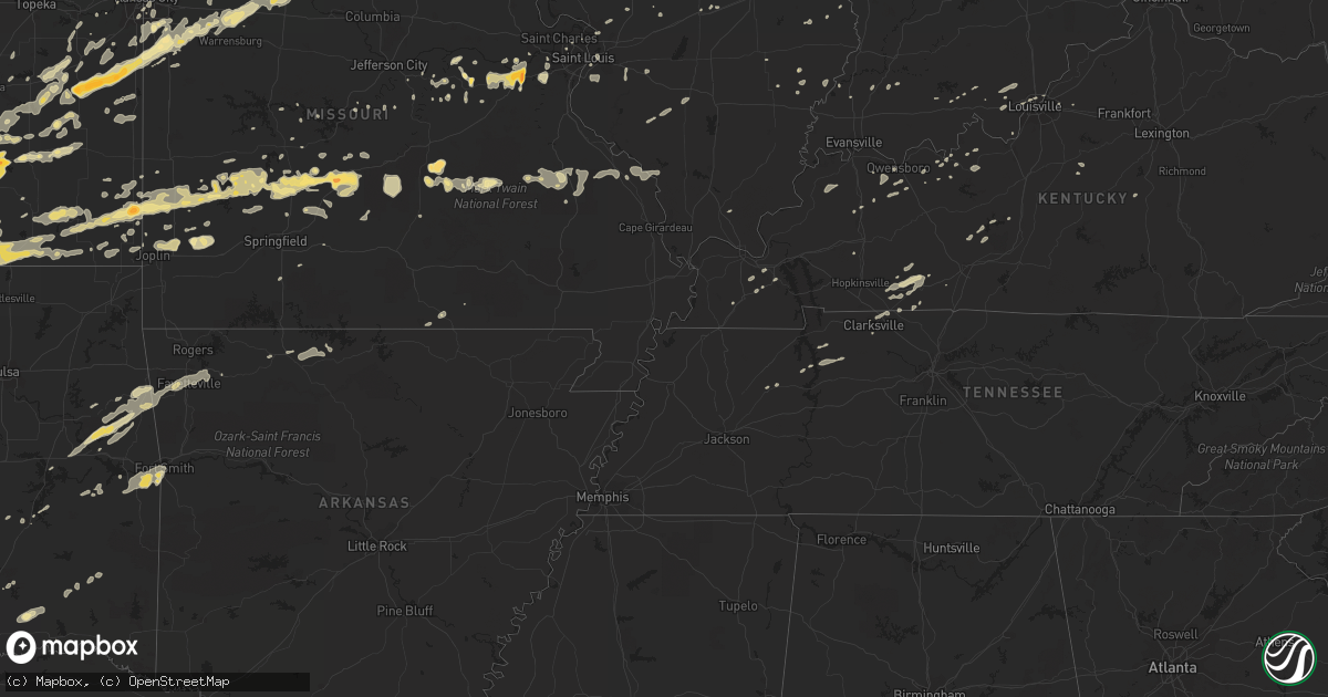
Hail Map in Illinois on February 27, 2011
Get this storm
February 27 map
$229
one time, instant access
Download today. No call, no setup
Keep the $229
Bought the map and want the full workflow? Apply the entire $229 to a subscription within 7 days. None of it is wasted.
Every map, not just this one
This buys you this map. Subscription and you get every map we run, in the markets you choose from a few cities to whole states to nationwide. Plus real-time alerts the moment a storm fires.
Contact data
Name, contact info, occupancy, even credit band for addresses in the footprint. You go from where it hit to who to call.
Become the source they trust
Unlimited branding weather history reports on demand. You already have the documented answer ready for the property owner, and you are the one who showed up with it.
Property data and RoofTrace estimates
Pull up any address you have got, its value and the exact code rules for that jurisdiction, straight from One Click Code. Then RoofTrace estimates the squares, pitch, and roof value, priced the way you price.
Storm reports in Illinois
Illinois
| Date | Description |
|---|---|
| 02/27/201111:45 AM CST | Structural damage to homes in troy |
| 02/27/20112:30 AM CST | 1 tree down over road |
| 02/27/20112:30 AM CST | Damage extended along new columbia rd from east of county road 700e to just east of co road 850e...approx 1 mile. Unoccupied mobile home lost its roof...numerous homes |
| 02/27/20111:43 AM CST | Winds estimated 60 to 65 mph with power outages. Transformer destoryed. |
| 02/27/20111:34 AM CST | A local report indicates 60 MPH wind near BELLMONT |
| 02/27/20111:30 AM CST | Community without power. Tree limbs down. |
| 02/27/20111:18 AM CST | Wind gusts lasted 3 to 4 minutes in the community of smithville located south of wayne city. |
| 02/27/20111:01 AM CST | Building damage at the orchardville church. |
| 02/27/20111:00 AM CST | Most of town is without power...sporadic power outages in centralia as well as parts of clinton and washington counties |
| 02/27/201112:55 AM CST | Five power poles snapped along us-45 north of flora. |
| 02/27/201112:45 AM CST | A 12x12 foot roof was blown off a small utility shed. |
| 02/27/201112:45 AM CST | One power pole and line down in town. |
| 02/27/201112:35 AM CST | Damage to a roof...unoccupied mobile home blown over and porch missing from house. |
| 02/27/201112:35 AM CST | Power poles bent over and tree limbs down |
| 02/27/201112:33 AM CST | Power poles bent over and damage to a pole barn |
| 02/27/201112:30 AM CST | Wind gusts of at least 60 mph. |
| 02/27/201112:30 AM CST | Power flashes seen...power lines down...medium sized limbs down |
| 02/27/201112:30 AM CST | A tree was blown down onto zion church road southeast of walsh. |
| 02/27/201112:20 AM CST | Citizens report of tornado damage to two homes...no injuries. |
| 02/27/201112:18 AM CST | Ham radio antennas blown down. |
| 02/27/201112:10 AM CST | Barn destroyed...power poles snapped. |
| 02/27/201112:05 AM CST | Power poles snapped. Extensive damage to a grain elevator. Metal roofs blown off of several buildings. |
| 02/27/201112:02 AM CST | Wind gusts of at least 60 mph |
| 02/27/201112:01 AM CST | A local report indicates 60 MPH wind near LITCHFIELD |
| 02/27/201112:00 AM CST | A local report indicates 61 MPH wind near NEW BADEN |
| 02/27/201112:00 AM CST | Heavy lawn furniture blown across yard |
| 02/26/201111:59 PM CST | Power outages |
| 02/26/201111:50 PM CST | Tractor trailer blown over on rte 177 |
| 02/26/201111:46 PM CST | A local report indicates 60 MPH wind near 1 NNW BETHALTO |
| 02/26/201111:45 PM CST | Structural damage to homes in troy |
| 02/26/201111:45 PM CST | 6-8 inch tree limbs blown down |
| 02/26/201111:44 PM CST | A local report indicates 70 MPH wind near EAST ST. LOUIS |
| 02/26/201111:43 PM CST | A local report indicates 60 MPH wind near COLLINSVILLE |
| 02/26/201111:40 PM CST | Parts of a barn roof and siding...a flattened shed...and a vehicle 20 plus yards off the roadway off of county road 21 near kuhn station road. |
| 02/26/201111:40 PM CST | Fence broken in half. Flagpole bent in half. Flagpole is rated to 70 mph. |
| 02/26/201111:40 PM CST | East of i-55....on stauton rd one half mile south of goshen...old barn flattened...large debris field |
| 02/26/201111:35 PM CST | Numerous trees and power lines down in granite city. Some roof damage reported. |
| 02/26/201111:35 PM CST | Est. 70mph winds... Half inch tree limbs down |
| 02/26/201111:35 PM CST | Most homes damaged near intersection of 40 and 143... Holes in siding... Trees blown down. |
| 02/26/201111:33 PM CST | A local report indicates 71 MPH wind near MARYVILLE |
| 02/26/201111:15 PM CST | Large trees down...3-4ft in diameter. South hill street |
| 02/26/20119:07 PM CST | Trees down across us 267 just north of whitlock road |
| 02/26/20118:56 PM CST | A local report indicates 1.00 inch wind near 1 N NORMAL |
| 02/26/20118:48 PM CST | A local report indicates 1.75 inch wind near 3 NW SHIRLEY |
| 02/26/20118:20 PM CST | A local report indicates 75 MPH wind near 1 S MOUNT STERLING |
| 02/26/20118:20 PM CST | A local report indicates 60 MPH wind near 3 S MOUNT STERLING |
| 02/26/20118:20 PM CST | A local report indicates 1.00 inch wind near 3 S MOUNT STERLING |
| 02/26/20118:16 PM CST | Hail covering the ground on armington road 1 mile east of i-155 and still falling at 824 pm. |
| 02/26/20118:10 PM CST | Mobile home shook...sucked equipment out of open garage door...blew swing set a considerable distance. |
| 02/26/20118:10 PM CST | Dozen mini storage barns scattered over one-quarter mile...on 25o north avenue between county roads 2700 and 2800. |
| 02/26/20117:15 PM CST | Golf ball size hail broke windows at a home 2 miles north of ray. |
| 02/26/20117:11 PM CST | A local report indicates 1.00 inch wind near RUSHVILLE |
| 02/26/20116:58 PM CST | A local report indicates 1.00 inch wind near 1 E GOLDEN |
| 02/26/20116:56 PM CST | Covering the ground to a depth of one-2 inches |
| 02/26/20116:50 PM CST | A local report indicates 1.00 inch wind near CAMP POINT |
| 02/26/20116:47 PM CST | A local report indicates 1.00 inch wind near COLUMBUS |
| 02/26/20116:45 PM CST | A local report indicates 1.00 inch wind near 1 S QUINCY |
| 02/26/20116:35 PM CST | Hail covering ground |
| 02/26/20116:31 PM CST | A local report indicates 1.00 inch wind near 8 SSE QUINCY |
| 02/26/20116:30 PM CST | A local report indicates 1.00 inch wind near 1 S QUINCY |
All States Impacted by Hail Map on February 27, 2011
Cities Impacted by Hail Map on February 27, 2011
- Champaign, IL
- Howard, KS
- Eaton, OH
- Richmond, IN
- Higginsville, MO
- Stewart, TN
- Greenfield, MO
- Arcola, MO
- Lockwood, MO
- Goldthwaite, TX
- Hamilton, TX
- Frontenac, KS
- Pittsburg, KS
- East Saint Louis, IL
- Eureka, MO
- Pacific, MO
- Pleasant Hill, MO
- Harrisonville, MO
- Huntsville, MO
- Winchester, IN
- Greenview, IL
- Long Lane, MO
- Buffalo, MO
- Stuart, OK
- Climax Springs, MO
- Edwards, MO
- Wellsville, KS
- Ottawa, KS
- Edgerton, KS
- Boss, MO
- Bixby, MO
- Westville, OK
- Summers, AR
- Proctor, OK
- Nashoba, OK
- Yellville, AR
- Wichita, KS
- Winamac, IN
- Oblong, IL
- Willow Hill, IL
- West Liberty, IL
- Greenwood, IN
- Indianapolis, IN
- Green Valley, IL
- Ballwin, MO
- Chesterfield, MO
- Virgil, KS
- Fall River, KS
- Neal, KS
- Rosalia, KS
- Beaumont, KS
- Leon, KS
- Piedmont, KS
- Toronto, KS
- Severy, KS
- Eureka, KS
- La Grange, MO
- Harmony, IN
- Knightsville, IN
- Reelsville, IN
- Terre Haute, IN
- Cloverdale, IN
- Amo, IN
- Clayton, IN
- Greencastle, IN
- Carbon, IN
- Danville, IN
- Brazil, IN
- Fillmore, IN
- Rosedale, IN
- Coatesville, IN
- Putnamville, IN
- El Dorado, KS
- Cassoday, KS
- Burns, KS
- Princeton, IN
- Frost, TX
- Mcalester, OK
- Mount Sterling, MO
- Hermann, MO
- Linn, MO
- Bland, MO
- Owensville, MO
- Staunton, IL
- Valley Mills, TX
- Jonesboro, TX
- Gatesville, TX
- Mattoon, IL
- Lerna, IL
- Windsor, IL
- Gays, IL
- Cottonwood Falls, KS
- Elmdale, KS
- Gardner, KS
- Spring Hill, KS
- Shelbina, MO
- Deer Creek, OK
- Medford, OK
- Salem, MO
- West Salem, IL
- Avon, IN
- Brownsburg, IN
- Licking, MO
- Raymondville, MO
- Bowie, TX
- Montague, TX
- Meridian, TX
- Clifton, TX
- Petersburg, IL
- Cumby, TX
- Lone Oak, TX
- Brashear, TX
- Campbell, TX
- Benton, KS
- Valley Center, KS
- Centerville, KS
- Jerico Springs, MO
- Augusta, MO
- Coatsburg, IL
- Payson, IL
- Clayton, IL
- Paloma, IL
- Quincy, IL
- Camp Point, IL
- Fowler, IL
- Liberty, IL
- Palmyra, MO
- Lewisburg, OH
- Bolivar, MO
- Half Way, MO
- Bloomington, IL
- Italy, TX
- Milford, TX
- Sherman, TX
- Farmington, MO
- Ashmore, IL
- Charleston, IL
- Trilla, IL
- Neoga, IL
- Saint Louis, MO
- Columbus, KS
- Scammon, KS
- Mode, IL
- Cowden, IL
- Beecher City, IL
- Shelbyville, IL
- Colony, KS
- Westphalia, KS
- Stockton, MO
- Coffeyville, KS
- Dexter, KS
- Shidler, OK
- Maple City, KS
- Peru, KS
- Caney, KS
- Independence, KS
- Cedar Vale, KS
- Niotaze, KS
- Sedan, KS
- Havana, KS
- Lewistown, IL
- Lamar, MO
- Argonia, KS
- Washington, MO
- Labadie, MO
- Gray Summit, MO
- Union, MO
- Villa Ridge, MO
- Lincoln, IL
- New Holland, IL
- Stanford, IL
- Armstrong, MO
- Garnett, KS
- Salisbury, MO
- Bates City, MO
- Blackburn, MO
- Sweet Springs, MO
- Kingsville, MO
- Greenwood, MO
- Mayview, MO
- Freeman, MO
- Peculiar, MO
- Cleveland, MO
- Holden, MO
- Clifton Hill, MO
- Glasgow, MO
- Paola, KS
- Drexel, MO
- Concordia, MO
- Centerview, MO
- Higbee, MO
- Malta Bend, MO
- La Cygne, KS
- Warrensburg, MO
- Miami, MO
- Gilliam, MO
- Fontana, KS
- Raymore, MO
- Dalton, MO
- Greeley, KS
- Fayette, MO
- Parker, KS
- Marshall, MO
- Rantoul, KS
- Strasburg, MO
- Odessa, MO
- Lone Jack, MO
- Lane, KS
- Alma, MO
- Keytesville, MO
- Osawatomie, KS
- Slater, MO
- Richmond, KS
- Louisburg, KS
- Noblesville, IN
- Ashland, IL
- Tallula, IL
- Browning, IL
- Havana, IL
- Astoria, IL
- Rushville, IL
- Vermont, IL
- Kansas City, KS
- Clarksville, TN
- Mill Creek, OK
- Macomb, IL
- Cicero, IN
- Prairie Village, KS
- Madill, OK
- Delavan, IL
- Emden, IL
- Chrisman, IL
- Paris, IL
- Clinton, IN
- Milford Center, OH
- San Jose, IL
- Ipava, IL
- Rolla, MO
- Saint James, MO
- Welda, KS
- Le Roy, KS
- Neosho Falls, KS
- Kincaid, KS
- Girard, KS
- Cherokee, KS
- Liberal, MO
- Mindenmines, MO
- Arcanum, OH
- New Madison, OH
- Ellery, IL
- Albion, IL
- Park Hill, OK
- Vian, OK
- Bunch, OK
- Gore, OK
- Cookson, OK
- Stilwell, OK
- Elk Falls, KS
- Moline, KS
- Congerville, IL
- Antlers, OK
- Boswell, OK
- Rosebud, MO
- Cuba, MO
- Winchester, IL
- Lorena, TX
- Muskogee, OK
- Welling, OK
- Iola, KS
- Lebanon, MO
- Stoutland, MO
- Soper, OK
- Kemp, TX
- Loraine, IL
- Plymouth, IL
- Huntsville, IL
- Golden, IL
- Littleton, IL
- Augusta, IL
- Frederick, IL
- Camden, IL
- Timewell, IL
- La Prairie, IL
- Mendon, IL
- Mount Sterling, IL
- Bowen, IL
- Martinsville, IL
- Casey, IL
- Doe Run, MO
- Pocola, OK
- Arkoma, OK
- Fort Smith, AR
- Grandview, MO
- Kansas City, MO
- Belton, MO
- Midland, PA
- Negley, OH
- Darlington, PA
- East Liverpool, OH
- De Soto, KS
- Greenwich, KS
- Towanda, KS
- Colwich, KS
- Kechi, KS
- Garden Plain, KS
- Goddard, KS
- Maize, KS
- Potwin, KS
- Reeds, MO
- Sarcoxie, MO
- Joplin, MO
- Carthage, MO
- Webb City, MO
- Carterville, MO
- Sparta, IL
- Cutler, IL
- Coulterville, IL
- Boaz, KY
- Hickory, KY
- Symsonia, KY
- Union City, OH
- Greenville, OH
- Ansonia, OH
- Williamsburg, KS
- Waverly, KS
- Aline, OK
- Kenton, OH
- Stilesville, IN
- Burdick, KS
- Lincolnville, KS
- Madison, KS
- Whitney, TX
- Malone, TX
- Forreston, TX
- Itasca, TX
- Mertens, TX
- Abbott, TX
- Aquilla, TX
- Hillsboro, TX
- Penelope, TX
- Bynum, TX
- Shelbyville, MO
- Evant, TX
- McLean, IL
- Urbana, OH
- Russellville, KY
- Adairville, KY
- Hico, TX
- Alpena, AR
- Beaver, PA
- Rogers, OH
- Beaver Falls, PA
- Lisbon, OH
- Industry, PA
- Holliday, MO
- Lewisburg, KY
- Elkton, KY
- Atlanta, IL
- Elizabeth, IN
- Normal, IL
- Berger, MO
- New Haven, MO
- Sidney, OH
- Shirley, IL
- Dana, IN
- Ridge Farm, IL
- Cayuga, IN
- Fishers, IN
- Union City, IN
- Commercial Point, OH
- Orient, OH
- Marshall, IN
- Huntingdon, TN
- Braman, OK
- Goltry, OK
- Nash, OK
- Pond Creek, OK
- Jet, OK
- Crowley, TX
- Hardinsburg, KY
- Greenville, IL
- De Graff, OH
- Rensselaer, IN
- Lenox, MO
- Edgar Springs, MO
- Lampasas, TX
- Morgan, TX
- Lometa, TX
- Purmela, TX
- Star, TX
- Cranfills Gap, TX
- Dadeville, MO
- Aldrich, MO
- Lees Summit, MO
- Lentner, MO
- Excello, MO
- Cairo, MO
- Clarence, MO
- Macon, MO
- Jacksonville, MO
- Anabel, MO
- Nardin, OK
- Arkansas City, KS
- Blackwell, OK
- Newkirk, OK
- Stotts City, MO
- La Russell, MO
- Miller, MO
- Clay City, IN
- English, IN
- Bethalto, IL
- Moro, IL
- Edwardsville, IL
- Heyworth, IL
- Council Grove, KS
- Spiro, OK
- Cannelton, IN
- Cloverport, KY
- Winslow, IN
- Maplewood, OH
- Jackson Center, OH
- Anna, OH
- Marengo, OH
- Centerburg, OH
- Gerald, MO
- Geuda Springs, KS
- Valley View, TX
- Waverly, TN
- Erin, TN
- Tennessee Ridge, TN
- Virginia, IL
- Louisburg, MO
- Wapakoneta, OH
- Garland, KS
- Bronaugh, MO
- Dunnegan, MO
- Fair Play, MO
- Farmington, AR
- Fayetteville, AR
- Argos, IN
- Piqua, KS
- Yates Center, KS
- Tishomingo, OK
- Minier, IL
- Snow, OK
- Rattan, OK
- Mason City, IL
- Easton, IL
- Stringtown, OK
- Griggsville, IL
- Bluffs, IL
- Chambersburg, IL
- Meredosia, IL
- Neodesha, KS
- Erie, KS
- Dennis, KS
- Galesburg, KS
- Cherryvale, KS
- Thayer, KS
- Parsons, KS
- Saint Paul, KS
- Millstadt, IL
- Columbia, IL
- Saint Henry, OH
- Maria Stein, OH
- New Weston, OH
- North Salem, IN
- Ladoga, IN
- Jamestown, IN
- New Ross, IN
- Collinsville, TX
- Tioga, TX
- Atoka, OK
- Oakdale, IL
- Nashville, IL
- Pinckneyville, IL
- Westfield, IL
- Marshall, IL
- Kansas, IL
- Hopedale, IL
- Armington, IL
- Princeton, KS
- Edna, KS
- Baldwin City, KS
- Hamilton, KS
- Gridley, KS
- Peck, KS
- Haysville, KS
- Whitesboro, TX
- Gainesville, TX
- Chapin, IL
- Oswego, KS
- Kinta, OK
- Stigler, OK
- Rockbridge, OH
- Fairfield, IL
- Beardstown, IL
- Lamont, OK
- Elk City, KS
- Bartlett, KS
- Altamont, KS
- Longton, KS
- Liberty, KS
- Helena, OK
- Utica, KY
- Calhoun, KY
- Oronogo, MO
- McCune, KS
- Oglesby, TX
- McGregor, TX
- Osage City, KS
- Fair Grove, MO
- Garden City, MO
- Mays, IN
- Rushville, IN
- Knightstown, IN
- Lebanon, IN
- Madison, MO
- Warner, OK
- Webbers Falls, OK
- Kilbourne, IL
- Pembroke Township, IL
- Sheldon, MO
- Sunset, TX
- Lane, OK
- Richland, MO
- Windyville, MO
- Asbury, MO
- Flemington, MO
- Phillipsburg, MO
- Mound Valley, KS
- Golden City, MO
- Weir, KS
- Mulberry, KS
- Humansville, MO
- Elkland, MO
- Franklin, KS
- Tunas, MO
- Butler, IN
- Auburn, IN
- Industry, IL
- Lewis, IN
- Middle Brook, MO
- Bismarck, MO
- Ironton, MO
- Belleview, MO
- Avilla, MO
- Marion, KS
- Georgetown, IN
- Hartsburg, IL
- Mannsville, OK
- Ardmore, OK
- Lawrence, KS
- Winfield, KS
- Modoc, IN
- Losantville, IN
- Parker City, IN
- Bokoshe, OK
- Muldrow, OK
- Roland, OK
- Demotte, IN
- Wheatfield, IN
- Essex, IL
- Bonfield, IL
- Millersburg, OH
- Garfield, KY
- Harned, KY
- Irvington, KY
- Sunbury, OH
- Belle, MO
- Bluff City, KS
- New Paris, OH
- Depauw, IN
- Eldridge, MO
- Covington, IN
- Veedersburg, IN
- Adair, IL
- Tuscumbia, MO
- Niangua, MO
- Conway, MO
- Mccordsville, IN
- Greenfield, IN
- Albany, IN
- Muncie, IN
- Farmland, IN
- Selma, IN
- Mount Vernon, OH
- Bellville, OH
- Fredericktown, OH
- Butler, OH
- Hannibal, MO
- Celina, OH
- Delaware, OH
- Ashley, OH
- Ridgeville, IN
- Portland, IN
- Patoka, IN
- Clearwater, KS
- Wellington, KS
- Medaryville, IN
- North Judson, IN
- Whitewater, KS
- Andale, KS
- Calvin, OK
- Owensboro, KY
- Cambridge City, IN
- Greens Fork, IN
- Webster, KY
- Danvers, IL
- Trenton, KY
- Ivesdale, IL
- Mayfield, KY
- Cooksville, IL
- College Corner, OH
- Somerville, OH
- Camden, OH
- Westport, IN
- Sadler, TX
- Moundville, MO
- Hanson, KY
- Prairie Grove, AR
- Flora, IL
- Piqua, OH
- Simpson, IL
- Leslie, MO
- Beaufort, MO
- Lynn, IN
- Pomona, KS
- Quenemo, KS
- Melvern, KS
- Crofton, KY
- Kingman, KS
- Newton, KS
- Freeburg, MO
- La Harpe, KS
- Humboldt, KS
- Jacksonville, IL
- Honobia, OK
- Bath, IL
- Polk, MO
- Defiance, MO
- Sheridan, IN
- Westfield, IN
- Belleville, IL
- Freeburg, IL
- Mascoutah, IL
- Paris, MO
- Gravois Mills, MO
- Marysville, OH
- Vandalia, MO
- Roundhill, KY
- Brownsville, KY
- Hillsboro, IL
- Taylor Springs, IL
- Litchfield, IL
- Walshville, IL
- Irving, IL
- Witt, IL
- Reading, KS
- Lebo, KS
- Tahlequah, OK
- Springdale, AR
- Elkins, AR
- Lincoln, AR
- South Haven, KS
- Fredericktown, MO
- Park Hills, MO
- Matfield Green, KS
- Table Grove, IL
- Marietta, IL
- Topeka, IL
- Palestine, OH
- Hollansburg, OH
- Hermitage, MO
- New Castle, IN
- Mooreland, IN
- Monroe City, MO
- Maywood, MO
- Ursa, IL
- Taylor, MO
- Durant, OK
- Caddo, OK
- Maryland Heights, MO
- Carrollton, MO
- Nokomis, IL
- Pana, IL
- Oconee, IL
- Rosamond, IL
- Waxahachie, TX
- Midlothian, TX
- Croton, OH
- Pittsfield, IL
- Jeffersonville, IN
- Lewisville, IN
- Straughn, IN
- Eddy, TX
- Waco, TX
- Riesel, TX
- Bruceville, TX
- Marlin, TX
- Chilton, TX
- Crawford, TX
- Moody, TX
- Hewitt, TX
- Montezuma, IN
- Bloomingdale, IN
- Rockville, IN
- Russellville, IN
- Hillsdale, IN
- Krebs, OK
- Archie, MO
- Lewistown, OH
- Robertsville, MO
- Carl Junction, MO
- Anthony, KS
- Fortville, IN
- Alexandria, IN
- Groveport, OH
- Ashville, OH
- Canal Winchester, OH
- Shawnee, KS
- Fountain City, IN
- Kentland, IN
- Robinson, IL
- Palestine, IL
- Derby, KS
- Mayfield, KS
- Conway Springs, KS
- Milan, KS
- Mountain Grove, MO
- Hartville, MO
- Birdseye, IN
- Poland, IN
- Bowling Green, IN
- Urbana, IL
- Grenola, KS
- Plato, MO
- Waynesville, MO
- Duke, MO
- Fort Leonard Wood, MO
- Newburg, MO
- Burlington, KS
- Saint Paris, OH
- Houston, OH
- Russia, OH
- Koshkonong, MO
- West Plains, MO
- Reynolds Station, KY
- Fordsville, KY
- Bellefontaine, OH
- Cheney, KS
- Murdock, KS
- Mount Carmel, IL
- Fountaintown, IN
- Florence, KS
- Sedgwick, KS
- Reddick, IL
- Bowling Green, MO
- Middletown, MO
- Curryville, MO
- Anderson, IN
- Shirley, IN
- Hudson, IL
- Towanda, IL
- Hawesville, KY
- Mccurtain, OK
- Ashley, IL
- Du Bois, IL
- Russells Point, OH
- Quincy, OH
- Tyro, KS
- Norborne, MO
- Stonewall, OK
- Overland Park, KS
- Falcon, MO
- Jasper, MO
- Versailles, IL
- Augusta, KS
- Big Sandy, TN
- Wheatland, MO
- Lexington, MO
- Montezuma, OH
- Keota, OK
- Eckerty, IN
- Jacob, IL
- Perryville, MO
- Frohna, MO
- Gorham, IL
- Thorntown, IN
- Laura, OH
- Ludlow Falls, OH
- Pitsburg, OH
- Pottsboro, TX
- Denison, TX
- Pierceton, IN
- Warsaw, IN
- Marshfield, MO
- Roachdale, IN
- Saint Jo, TX
- Harrod, OH
- Alger, OH
- Peabody, KS
- Cedar Lake, IN
- New Bremen, OH
- Altamont, IL
- Fletcher, OH
- Emporia, KS
- Olpe, KS
- Huntsville, OH
- Chamois, MO
- Meta, MO
- Saint Elizabeth, MO
- Mound City, KS
- Pleasanton, KS
- Louisville, KY
- Simpsonville, KY
- Marengo, IN
- Fredonia, KS
- Mooresville, IN
- Bainbridge, IN
- Kopperl, TX
- Blum, TX
- Cumberland Furnace, TN
- Vanleer, TN
- Cumberland City, TN
- Highlandville, MO
- Urbana, MO
- Ennis, TX
- Middletown, IN
- Daleville, IN
- Saint Mary, MO
- Woodway, TX
- Laurel, IN
- Rockport, IL
- Munfordville, KY
- Wildwood, MO
- Saint Clair, MO
- Cartwright, OK
- Panama, IL
- Sorento, IL
- Huntsville, AR
- Hindsville, AR
- Danville, KY
- Stanford, KY
- Howe, TX
- Rose Hill, KS
- Ada, OH
- Churubusco, IN
- Albion, IN
- Versailles, OH
- Bradford, OH
- Covington, OH
- Brownstown, IL
- Saint Elmo, IL
- Strawn, IL
- Eudora, KS
- New Knoxville, OH
- Osceola, MO
- Quincy, MO
- Morganfield, KY
- Alton, MO
- Bruceton, TN
- Marthasville, MO
- Hepler, KS
- Uniontown, KS
- Guthrie, KY
- Allensville, KY
- Adams, TN
- Quinton, OK
- Hulbert, OK
- Centerpoint, IN
- Clark, MO
- Walnut, KS
- Manitou, KY
- Ellsworth, IL
- Pendleton, IN
- Jewett, IL
- Greenup, IL
- Fort Recovery, OH
- Coal City, IN
- Sainte Genevieve, MO
- Bunker, MO
- Seymour, MO
- Toledo, IL
- Macks Creek, MO
- Wellington, MO
- Spiceland, IN
- Dunkirk, OH
- Dola, OH
- Arcadia, KS
- Farlington, KS
- Arma, KS
- Woodburn, KY
- Hartford, KS
- Grant, OK
- Hugo, OK
- Williamsburg, IN
- Douglass, KS
- Caney, OK
- Newark, OH
- Granville, OH
- Gilman, IL
- Chatsworth, IL
- Onarga, IL
- Piper City, IL
- Stover, MO
- Lincoln, MO
- Ostrander, OH
- Botkins, OH
- Hartford, IL
- East Alton, IL
- Clarksville, IN
- Falls Of Rough, KY
- Moran, KS
- Heath, OH
- Loose Creek, MO
- New Albany, IN
- Maypearl, TX
- Venus, TX
- Moberly, MO
- Whitesville, KY
- Slaughters, KY
- Rumsey, KY
- Arenzville, IL
- Concord, IL
- New Salem, IL
- New Canton, IL
- Eldon, MO
- Shumway, IL
- Sigel, IL
- Stewardson, IL
- Rushsylvania, OH
- West Mansfield, OH
- Forest, OH
- Philpot, KY
- Conover, OH
- West Terre Haute, IN
- Springfield, KY
- Bardstown, KY
- Harrison, AR
- Lead Hill, AR
- Benton, KY
- Olmstead, KY
- Otwell, IN
- Borden, IN
- Greenville, IN
- Pekin, IN
- Palmyra, IN
- New Salisbury, IN
- Cross Timbers, MO
- Zanesville, OH
- Mount Perry, OH
- Roseville, OH
- Martinton, IL
- Bee Spring, KY
- Sweeden, KY
- Waverly, MO
- Ashkum, IL
- Danforth, IL
- Waveland, IN
- Crawfordsville, IN
- Rankin, IL
- Spivey, KS
- Ridgeway, OH
- Mount Victory, OH
- Coldwater, OH
- Stilwell, KS
- Grain Valley, MO
- Brunswick, MO
- Bucyrus, KS
- Oak Grove, MO
- West Liberty, OH
- Cable, OH
- Howard, OH
- Danville, OH
- Freeport, KS
- Clarkson, KY
- Clifton, IL
- Hagerstown, IN
- Economy, IN
- Corydon, IN
- Red Oak, TX
- Sullivan, MO
- Sparta, MO
- Downs, IL
- Le Roy, IL
- Beaverville, IL
- Saint Anne, IL
- Minster, OH
- Sharon Grove, KY
- Collins, MO
- Morocco, IN
- Lake Village, IN
- Killbuck, OH
- Glenmont, OH
- Yorktown, IN
- Willard, MO
- Walnut Grove, MO
- Morrisville, MO
- Petersburg, IN
- Tipp City, OH
- West Milton, OH
- Bourbonnais, IL
- Albers, IL
- Germantown, IL
- Emden, MO
- Monterey, IN
- Fort Worth, TX
- Galena, KS
- Wilkinson, IN
- Pawhuska, OK
- Checotah, OK
- Brook, IN
- Leawood, KS
- Knob Noster, MO
- Chetopa, KS
- Roundhead, OH
- Lakeview, OH
- Liberty, IN
- Saint Marys, OH
- Sugarcreek, OH
- Baltic, OH


