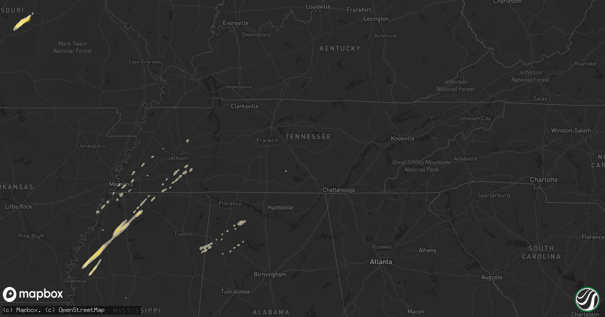
Hail Map in Tennessee on January 29, 2013
Get this storm
January 29 map
$229
one time, instant access
Download today. No call, no setup
Keep the $229
Bought the map and want the full workflow? Apply the entire $229 to a subscription within 7 days. None of it is wasted.
Every map, not just this one
This buys you this map. Subscription and you get every map we run, in the markets you choose from a few cities to whole states to nationwide. Plus real-time alerts the moment a storm fires.
Contact data
Name, contact info, occupancy, even credit band for addresses in the footprint. You go from where it hit to who to call.
Become the source they trust
Unlimited branding weather history reports on demand. You already have the documented answer ready for the property owner, and you are the one who showed up with it.
Property data and RoofTrace estimates
Pull up any address you have got, its value and the exact code rules for that jurisdiction, straight from One Click Code. Then RoofTrace estimates the squares, pitch, and roof value, priced the way you price.
Storm reports in Tennessee
Tennessee
| Date | Description |
|---|---|
| 01/29/20135:45 AM CST | A few trees were downed across the county. |
| 01/29/20135:30 AM CST | Several trees down. Minor roof damage on a building close to the intersection of hwy 41 and hwy 53. |
| 01/29/20135:26 AM CST | Initial damage consisting of snapped trees and a destroyed scoreboard was noted at the coffee county middle school. Intermittent damage...consisting of dozens of snappe |
| 01/29/20135:24 AM CST | Old press box blown off stand at football field in manchester...trees down in the area as well |
| 01/29/20135:15 AM CST | A few trees and power lines were downed across roadways in the western portion of the county. |
| 01/29/20135:11 AM CST | Woods ferry rd. Blocked by trees |
| 01/29/20135:00 AM CST | A few trees were downed across the county. |
| 01/29/20134:53 AM CST | An ef-1 tornado traveled over 5 miles impacting portions of west-central lincoln county tn between the towns of dellrose and fayetteville. The tornado was its strongest |
| 01/29/20134:45 AM CST | A few trees falling on power lines causing power outages across northeast and eastern portions of the county. |
| 01/29/20134:43 AM CST | Trees and power lines down |
| 01/29/20134:38 AM CST | Trees and power lines are down across the following roads...union hill rd.... Mosey purcell rd.... Bakerton pea ridge firetower rd.... Mccormick ridge rd.... And commer |
| 01/29/20134:35 AM CST | Out buildings damaged and a residential trailer blown off its foundation at the 4000 block along gassaway rd. |
| 01/29/20134:33 AM CST | State highway 53 near mile marker 3 is closed due to trees down across the road. |
| 01/29/20134:33 AM CST | Ef-0 tornado touched down 4 miles northeast of woodbury along highway 53. |
| 01/29/20134:30 AM CST | Several trees and power lines down in clay county...also damage to barn roofs and silos |
| 01/29/20134:29 AM CST | Ef-0 tornado touched down 1 mile north of woodbury along doolittle road. Damage included about a hundred snapped or uprooted trees and minor roof and structural damage. |
| 01/29/20134:25 AM CST | Roof off building and debris blocking road at homer scott road in castalian springs |
| 01/29/20134:21 AM CST | Gasline break at highland academy in portland. Student evacuated. |
| 01/29/20134:13 AM CST | Tree on mobile home with people trapped inside on north dickerson chapel road. |
| 01/29/20134:10 AM CST | A large portion of the roof was blown off a local country store called the stagecoach in dickson springs. A small storage barn also collapsed. Numerous trees down acros |
| 01/29/20134:06 AM CST | Roof off house and trees blocking road at 600 block of canoe branch road |
| 01/29/20134:05 AM CST | A lot of trees downed across the county. |
| 01/29/20134:01 AM CST | An nws storm survey team has confirmed ef0 tornado damage in northeast macon county about 7 miles northeast of lafayette. The tornado touched down along owens rd. Just |
| 01/29/20134:00 AM CST | A lot of trees downed across the county especially in and around mount pleasant. |
| 01/29/20133:58 AM CST | Apple barn building with partial roof missing in castalian springs |
| 01/29/20133:58 AM CST | Apple barn building with partial roof missing in castalian springs |
| 01/29/20133:56 AM CST | Partial roof blown off 1400 block of west main street. Wilson county cattle barn. |
| 01/29/20133:54 AM CST | Top floor of 3 story building gone in mount juliet on lebanon road |
| 01/29/20133:52 AM CST | At least 40 homes with roof damage. |
| 01/29/20133:52 AM CST | In trousdale county along hwy 25 there was considerable damage to sheds and outbuildings ...dozens of trees were snapped...and a home had porch columns blown out. This |
| 01/29/20133:51 AM CST | Trees down and roof damage reported in dixon springs |
| 01/29/20133:51 AM CST | Trees down along hickory grove road in walterhill |
| 01/29/20133:51 AM CST | Several trees were downed across the county. |
| 01/29/20133:50 AM CST | Numerous trees uprooted at 11895 highway 25 e near smith county line. |
| 01/29/20133:49 AM CST | Structural damage to second floor of a brick building. Relayed from nws huntsville. |
| 01/29/20133:47 AM CST | Dozens of trees were snapped...a couple older barns were destroyed... And an outbuilding was damaged along an approximate 1 mile path over far southwestern macon county |
| 01/29/20133:46 AM CST | Several buildings damaged along lebanon road in mount juliet |
| 01/29/20133:45 AM CST | Tree down on a house at 1413 n. Dickerson chapel rd. About 25 other trees twisted and uprooted. |
| 01/29/20133:45 AM CST | Possible tornado damage. A horse farm had building damage. Porch on the house was destroyed. Sheet metal and lumber debris scattered. |
| 01/29/20133:43 AM CST | Nws storm survey team found trees twisted and structural damage to house and numerous out buildings and barns the result of straight line wind damage. |
| 01/29/20133:43 AM CST | Tree hit house at 7720 covington rd in cross plains. No power. |
| 01/29/20133:42 AM CST | An ef0 tornado touched down 4 miles east-southeast of bethpage in eastern sumner county before lifting in far northwest trousdale county. Numerous trees were snapped or |
| 01/29/20133:41 AM CST | An nws storm survey confirmed an ef1 tornado touched down west of eagleville before lifting northeast of town. Two farm buildings were damaged along hwy 11 and a couple |
| 01/29/20133:41 AM CST | An nws storm survey found tstm wind damage in smyrna. An apartment complex had minor roof damage on weakley ln and a tree fell on a home on nissan dr. A barn was damage |
| 01/29/20133:40 AM CST | Trees down along burford rd. Between belotes ferry and cedar grove. |
| 01/29/20133:40 AM CST | Multiple trees down and roof damage at 1410 ardee rd in inglewood |
| 01/29/20133:40 AM CST | Trees down and blocking old laguardo rd |
| 01/29/20133:40 AM CST | Porches off houses and trees down across roads near the trousdale wilson county line. |
| 01/29/20133:40 AM CST | Initial damage was noted along mann road in northern wilson county where numerous trees were snapped and minor roof damage was noted. Intermittent damage consisting of |
| 01/29/20133:39 AM CST | A brief weak tornado knocked down a few trees near highway 25 and harsh lane. |
| 01/29/20133:39 AM CST | A brief weak tornado knocked down a few trees. |
| 01/29/20133:38 AM CST | A brief weak tornado knocked down a few trees near the entrance to bledsoe creek state park east of gallatin. |
| 01/29/20133:38 AM CST | A brief weak tornado knocked down a few trees near the entrance to bledsoe creek state park east of gallatin. |
| 01/29/20133:37 AM CST | Woods ferry rd. Blocked by trees |
| 01/29/20133:37 AM CST | An ef0 tornado touched down 2 miles southwest of bethpage along alexander lane then moved east before lifting in far northwest trousdale county east of gravel hill road |
| 01/29/20133:37 AM CST | Trees down in a line on alexander road |
| 01/29/20133:34 AM CST | An ef0 tornado touched down near the intersection of hwy 25 and harsh lane directly impacting the apple market with minor roof damage. As the tornado traveled 1.0 miles |
| 01/29/20133:34 AM CST | An nws storm survey found a two mile long by one half mile wide area of wind damage in far southeast williamson county. A barn was damaged on flat creek rd and two home |
| 01/29/20133:33 AM CST | Trees and power lines down on lock 4 road in gallatin. Also damage reported at gallatin marina. |
| 01/29/20133:30 AM CST | Nws storm survey team has determined that straight line winds caused the damage along nubia road northwest of westmoreland. Majority of the damage was isolated trees th |
| 01/29/20133:30 AM CST | Tree on mobile home and knocked off foundation in hohenwald |
| 01/29/20133:28 AM CST | Nws storm survey team confirmed ef0 tornado damage in the fairview plantation area of southwest gallatin up to the 109 intersection. Most of the damage was a result of |
| 01/29/20133:28 AM CST | At fairview plantation reports of bark ripped off trees... Twisted metal debri... And top story torn off old brick building |
| 01/29/20133:28 AM CST | Damage to cooks methodist church |
| 01/29/20133:28 AM CST | Roof missing on house in white bluff |
| 01/29/20133:28 AM CST | Along browns ln and woodlake dr... Reports of trees down... Windows broken and roof damage. |
| 01/29/20133:25 AM CST | Nws nashville personnel confirmed an ef2 tornado touched down in mount juliet on glenwood drive and lifted near cooks church road. Numerous businesses received minor to |
| 01/29/20133:24 AM CST | A weak tornado began near the intersection of highway 258 and sandy valley road...then continued east to near upper station camp creek road. Some trees were knocked dow |
| 01/29/20133:24 AM CST | Microburst with maximum winds near 85 mph began along meadows road near the west carter road intersection. The last evidence of damage was along fleming road road north |
| 01/29/20133:23 AM CST | An ef0 tornado touched down near the intersection of hwy 31 and shute lane. Numerous trees were uprooted or snapped with some trees falling on homes. Several homes had |
| 01/29/20133:22 AM CST | Trees and power lines down and barns blown down. Large street sign down and other tree debris along centerpoint rd. |
| 01/29/20133:21 AM CST | Four homes with roof and window damage. One home had its garage blown into the road. Many trees were snapped or uprooted. |
| 01/29/20133:20 AM CST | Large trees down in goodlettsville |
| 01/29/20133:20 AM CST | Report of broken windows... Damaged barn... And walnut tree uprooted |
| 01/29/20133:20 AM CST | Trees uprooted and back porch damaged in cottontown |
| 01/29/20133:20 AM CST | A nws storm survey found a large area of scattered wind damage from mallory lane to wilson pike. Two schools and several homes received roof damage in the area and scat |
| 01/29/20133:19 AM CST | Numerous trees and power lines down across the county including several trees on homes in the city of franklin. |
| 01/29/20133:19 AM CST | An ef0 tornado touched down near the intersection of tyree springs road and sandy valley road destroying two garage buildings. Numerous trees were snapped and uprooted. |
| 01/29/20133:18 AM CST | A nws storm survey confirmed an ef0 tornado briefly touched down just east of downtown franklin. Four businesses were damaged along fort granger dr and eddy ln. Several |
| 01/29/20133:15 AM CST | An ef1 tornado crossed interstate 65 from robertson county and caused numerous snapped and uprooted trees one mile north of the hwy 25 and hwy 31 junction. This tornado |
| 01/29/20133:15 AM CST | A nws storm survey found a one half mile wide area of wind damage from around 1 mi west of downtown franklin into the downtown area. Scattered trees...power lines...and |
| 01/29/20133:14 AM CST | An nws storm survey noted scattered downburst wind damage up to 1 mile south of the ef0 east nashville tornado. Scattered trees...tree limbs...and fences were blown dow |
| 01/29/20133:13 AM CST | Ef-0 tornado touchdown occurred near the intersection of dickerson pike and trinity lane. |
| 01/29/20133:12 AM CST | *** 1 inj *** an ef0 tornado touched down northeast of the i-65 and trinity ln interchange and moved eastward before lifting in inglewood near mcgavock pike. Several mo |
| 01/29/20133:10 AM CST | Microburst with maximum winds around 85 mph caused significant roof damage to a residence along ashwood rd and downed approximately 100 trees from ashwood rd to canaan |
| 01/29/20133:10 AM CST | At 7720 covington road...just outside of cross plains...several trees were downed across the area with power lines downed and a barn destroyed. |
| 01/29/20133:09 AM CST | Tree down across jocelyn hollow rd. |
| 01/29/20133:08 AM CST | Numerous trees were reported down in fairview. |
| 01/29/20133:08 AM CST | Numerous trees and powerlines down blocking roadways |
| 01/29/20133:08 AM CST | Large tree and power line down in west nashville along foundry dr and robertson rd. |
| 01/29/20133:07 AM CST | *** 1 fatal *** man was reportedly killed taking shelter in a shed on abernathy road. |
| 01/29/20133:07 AM CST | Numerous trees and power lines downed across the county with also some reports of roof damage across the county too. |
| 01/29/20133:06 AM CST | *** 1 inj *** an ef1 tornado touched down along pinson school road and traveled across possum trot road uprooting and snapping several trees. Once the tornado crossed t |
| 01/29/20133:05 AM CST | Tree across hwy 43. Building collapse in lawrenceburg |
| 01/29/20133:05 AM CST | *** 1 inj *** robertson county emergency management reported a path of damage from southwest to northeast across southern robertson county. 20 homes and several barns s |
| 01/29/20133:05 AM CST | Trees and powerlines down and structural damage to some barns reported along old greenbrier pike |
| 01/29/20133:00 AM CST | Several trees downed across the county with power outages throughout the county with some structure damage especially in hohenwald on rush branch road. |
| 01/29/20133:00 AM CST | An nws storm survey team confirmed ef0 tornado damage near the town of joelton from the january 30th 2013 event. The path began along harper road south of interstate 24 |
| 01/29/20132:59 AM CST | A nws storm survey found wind damage along pinewood rd east of walker hill rd in western williamson county. One barn was damaged and several trees were snapped or uproo |
| 01/29/20132:55 AM CST | An ef-0 tornado moved through the joelton area. Damage began along harper rd where large trees were uprooted. Mainly tree damage occurred along the 3.8 mile path that e |
| 01/29/20132:55 AM CST | A couple of trees down and power outages in the southern portion of the county on morris and long branch road. |
| 01/29/20132:53 AM CST | Power lines down in kingston springs...also a fallen tree reported on a building |
| 01/29/20132:52 AM CST | 4 foot diameter oak tree completely gone along pine bluff rd. |
| 01/29/20132:52 AM CST | Nws damage survey along grinder creek rd and summertown hwy in lewis county revealed a microburst with maximum winds around 85 mph occurred. The damage path was approxi |
| 01/29/20132:52 AM CST | Trees down and roof damage along walker cemetery rd and shahan rd. |
| 01/29/20132:52 AM CST | *** 1 inj *** an ef0 tornado briefly touched down in ashland city along gloria circle and stratton blvd. Some minor roof damage occurred and several trees were uprooted |
| 01/29/20132:51 AM CST | Two trees down and an open air building destroyed. |
| 01/29/20132:47 AM CST | Trees down along hwy 48 in dickson county |
| 01/29/20132:45 AM CST | Nws storm survey team confirmed that an ef0 tornado touched down along white bluff rd in southeast dickson county around 245 am where minor tree and structural damage o |
| 01/29/20132:41 AM CST | Several trees and power lines downed along with roof damage to homes along state highway 48. |
| 01/29/20132:35 AM CST | At least 15 houses damaged....some destroyed along hwy 438....from hwy 50 west to the perry county line |
| 01/29/20132:35 AM CST | An update on damage in the coble community. At least three homes damaged with trees and power lines blocking roads into the area. |
| 01/29/20132:32 AM CST | An ef-1 tornado was surveyed north of waynesboro on harris rd. |
| 01/29/20132:26 AM CST | Nws storm survey confirms an ef-2 tornado in hickman county. The tornado began near wolf creek rd west of the coble community and ended between beaverdam road and hwy 5 |
| 01/29/20132:13 AM CST | A couple trees down in waverly along hwy 230 and hwy 13. |
| 01/29/20132:12 AM CST | Ef-1 tornado surveyed near hurricane mills by nws storm survey. |
| 01/29/20132:10 AM CST | Television media reported significant damage to the loretta lynn ranch and museum in hurricane mills. Several outbuildings were destroyed and the loretta lynn home had |
| 01/29/20132:04 AM CST | Building damage reported on roby drive in erin. Several trees and power lines down in the area as well |
| 01/29/20131:49 AM CST | A loft was blown off a barn and 3 other out buildings damaged or nearly destroyed. Winds estimated at 70 mph. |
| 01/29/20131:45 AM CST | Numerous homes damaged...trees down...power lines down and roads closed...mainly around the center of chester county. Large barn completely destroyed in the jacks creek |
| 01/29/20131:38 AM CST | Possible tornado. A person trapped beneath a mobile home along with several additional persons trapped in homes along south parkway in bethel springs. In addition...a v |
| 01/29/20131:38 AM CST | Possible tornado. Numerous trees and powerlines reported down along with a home on fire in area of wind damage. Rescue unable to reach persons trapped due to impassable |
| 01/29/20131:35 AM CST | Possible tornado near bethel springs in mcnairy county. Trees reported down on a vehicle with occupants trapped. |
| 01/29/20131:25 AM CST | A couple of trees down scattered across the county. |
| 01/29/20131:04 AM CST | Sawmill damaged at 3445 hwy 138. Several buildings damaged or collapsed on site. Also multiple reports of damage in bolivar. Possible tornado. |
| 01/29/201312:45 AM CST | *** 3 inj *** possible tornado went from west to east across county. Numerous trees and power lines down. Structure damage. One home destroyed. Reports of numerous road |
| 01/28/201311:30 PM CST | Very large best buy business sign was broken and blown down by wind. Located on west side of germantown road 2755 north germantown road. |
| 01/28/201311:30 PM CST | Estimated 70 mph wind near hwy 385 and us 70. |
| 01/28/201311:21 PM CST | Tree down on power lines |
| 01/28/201311:15 PM CST | Estimated gust with heavy rains. |
| 01/28/201311:00 PM CST | Several large trees down in the university of memphis area. |
All States Impacted by Hail Map on January 29, 2013
Cities Impacted by Hail Map on January 29, 2013
- Decatur, TX
- Comanche, TX
- Neodesha, KS
- Hickory Valley, TN
- Memphis, TN
- Southaven, MS
- Lavinia, TN
- Irving, TX
- Thayer, KS
- Jacksboro, TX
- Poolville, TX
- Weatherford, TX
- Cedar Vale, KS
- Shidler, OK
- Robinsonville, MS
- Osceola, MO
- Dixon, MO
- Vienna, MO
- Scotland, AR
- Rich Hill, MO
- Butler, MO
- Hume, MO
- Desdemona, TX
- Mingus, TX
- Stephenville, TX
- Dublin, TX
- Drumright, OK
- Santo, TX
- Huntsville, TX
- Cleveland, AR
- Bolingbrook, IL
- Romeoville, IL
- Hennessey, OK
- Mineral Wells, TX
- Springtown, TX
- Green Ridge, MO
- Fairbury, IL
- Strawn, IL
- Forrest, IL
- Hico, TX
- Oswego, IL
- Bowie, TX
- Bryson, TX
- Jermyn, TX
- Henrietta, TX
- Bellevue, TX
- Blanket, TX
- May, TX
- Sidney, TX
- De Leon, TX
- Alamo, TN
- Marshall, OK
- Red Rock, OK
- Dover, OK
- Lucien, OK
- Garber, OK
- Perry, OK
- Orlando, OK
- Fairmont, OK
- Covington, OK
- Billings, OK
- Morrison, OK
- Douglas, OK
- Bison, OK
- Crocker, MO
- Peggs, OK
- Graham, TX
- Centertown, MO
- Jefferson City, MO
- Hartsburg, MO
- Sardis, MS
- Rising Star, TX
- Gorman, TX
- Shaw, MS
- Doddsville, MS
- Ruleville, MS
- Indianola, MS
- Perrysville, IN
- Cayuga, IN
- Berryville, AR
- Cameron, TX
- West Memphis, AR
- Paradise, TX
- Bridgeport, TX
- Chico, TX
- Baird, TX
- Cross Plains, TX
- Arcadia, KS
- Mulberry, KS
- Lowry City, MO
- Millington, TN
- Arlington, TN
- Lufkin, TX
- Richland, MO
- Giddings, TX
- Lincoln, TX
- Batesville, MS
- Lexington, TX
- Thrall, TX
- Thorndale, TX
- Rockdale, TX
- Ponca City, OK
- Cleveland, MS
- Boyle, MS
- Electra, TX
- Rattan, OK
- Early, TX
- Brownwood, TX
- Saulsbury, TN
- Grand Junction, TN
- Richards, TX
- Millsap, TX
- Tippecanoe, IN
- Kewanna, IN
- Rochester, IN
- Argos, IN
- Star City, IN
- Mentone, IN
- Bourbon, IN
- Winamac, IN
- Etna Green, IN
- Caledonia, IL
- Poplar Grove, IL
- Lockwood, MO
- Arcola, MO
- Greenfield, MO
- Humboldt, KS
- Savonburg, KS
- Chrisman, IL
- Tunica, MS
- Clyde, TX
- Mount Hope, AL
- Moulton, AL
- Carlton, TX
- Kaw City, OK
- Henderson, TN
- Toone, TN
- Medon, TN
- Dardanelle, AR
- Atkins, AR
- Hattieville, AR
- Sedan, KS
- Peru, KS
- Muskogee, OK
- Apple Springs, TX
- Lampe, MO
- Finger, TN
- Covington, TN
- Mason, TN
- Phil Campbell, AL
- Russellville, AL
- Zephyr, TX
- Somerville, TN
- Tolar, TX
- Perkins, OK
- Altoona, KS
- Hickory Hills, IL
- Joliet, IL
- Town Creek, AL
- Palos Park, IL
- Lemont, IL
- Bloomington, IL
- Towanda, IL
- Normal, IL
- Cooksville, IL
- Hamilton, AL
- Waynesville, MO
- Ryan, OK
- Merigold, MS
- Drew, MS
- Tutwiler, MS
- Parchman, MS
- Courtland, MS
- Lambert, MS
- Holly Springs, MS
- Como, MS
- Crenshaw, MS
- Vance, MS
- Marks, MS
- Benoit, MS
- Senatobia, MS
- Crescent, OK
- Kingfisher, OK
- Tonkawa, OK
- Loyal, OK
- Lamar, MS
- Breckenridge, TX
- Burbank, OK
- Fort Scott, KS
- Redfield, KS
- Uniontown, KS
- Daisy, OK
- Middleton, TN
- Marlin, TX
- Fennville, MI
- Henryetta, OK
- Okmulgee, OK
- Liberty, KS
- Edna, KS
- Coffeyville, KS
- Marland, OK
- Pawnee, OK
- Pawhuska, OK
- Shelbyville, TN
- Wann, OK
- Erie, KS
- Galesburg, KS
- Round Top, TX
- Burton, TX
- Wichita Falls, TX
- Oklahoma City, OK
- Arlington, TX
- Hamilton, TX
- Smithville, TX
- Nauvoo, AL
- Lynn, AL
- Sedalia, MO
- La Monte, MO
- Bastrop, TX
- Palo Pinto, TX
- Gordon, TX
- Lipan, TX
- Hornsby, TN
- Bolivar, TN
- Eufaula, OK
- Shawnee, OK
- Mansfield, TX
- Burleson, TX
- Fort Worth, TX
- Byhalia, MS
- Red Banks, MS
- Rayville, LA
- Boyd, TX
- Fletcher, OK
- Cement, OK
- Coldwater, MS
- Aurora, IL
- Grand Prairie, TX
- Horn Lake, MS
- Nesbit, MS
- Wister, OK
- Amory, MS
- Detroit, AL
- Sulligent, AL
- Greenwood Springs, MS
- Lenapah, OK
- Milano, TX
- Golden City, MO
- Sturgis, MI
- Waurika, OK
- Ringling, OK
- Glencoe, OK
- S Coffeyville, OK
- Altamont, KS
- Moline, KS
- Grenola, KS
- Cordova, TN
- Bixby, OK
- Haskell, OK
- El Dorado Springs, MO
- Collins, MO
- Antlers, OK
- Covington, IN
- Mustang, OK
- Lyon, MS
- Coahoma, MS
- Bethel Springs, TN
- Winfield, AL
- Eldridge, AL
- Elk City, KS
- Oswego, KS
- Parsons, KS
- McCune, KS
- Stark, KS
- Brownsville, TN
- Hackleburg, AL
- Graford, TX
- Lexington, IL
- Duncan, OK
- Boley, OK
- California, MO
- Booneville, AR
- Cropsey, IL
- Atlanta, IL
- Durant, MS
- Groveton, TX
- Lockport, IL
- Homer Glen, IL
- Bear Creek, AL
- Haleyville, AL
- Double Springs, AL
- Tuttle, OK
- Perrin, TX
- Newkirk, OK
- Russellville, MO
- Liberal, MO
- Paige, TX
- Seminole, OK
- Windthorst, TX
- Loving, TX
- Lake Cormorant, MS
- Warsaw, IN
- Morris, IL
- Seneca, IL
- Marseilles, IL
- Dewey, OK
- Spavinaw, OK
- Lincoln, IL
- Chanute, KS
- Talihina, OK
- Geary, OK
- Watonga, OK
- Calumet, OK
- Okarche, OK
- Bethany, OK
- Sentinel, OK
- Canute, OK
- Dill City, OK
- Carter, OK
- Foss, OK


