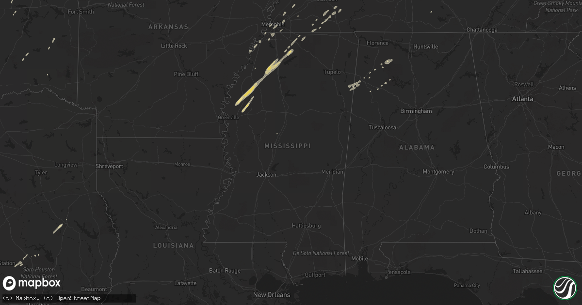
Hail Map in Mississippi on January 29, 2013
Get this storm
January 29 map
$229
one time, instant access
Download today. No call, no setup
Keep the $229
Bought the map and want the full workflow? Apply the entire $229 to a subscription within 7 days. None of it is wasted.
Every map, not just this one
This buys you this map. Subscription and you get every map we run, in the markets you choose from a few cities to whole states to nationwide. Plus real-time alerts the moment a storm fires.
Contact data
Name, contact info, occupancy, even credit band for addresses in the footprint. You go from where it hit to who to call.
Become the source they trust
Unlimited branding weather history reports on demand. You already have the documented answer ready for the property owner, and you are the one who showed up with it.
Property data and RoofTrace estimates
Pull up any address you have got, its value and the exact code rules for that jurisdiction, straight from One Click Code. Then RoofTrace estimates the squares, pitch, and roof value, priced the way you price.
Storm reports in Mississippi
Mississippi
| Date | Description |
|---|---|
| 01/29/20135:30 AM CST | Tree was blown down and blocking hwy 18 e. |
| 01/29/20134:53 AM CST | Tree on a house in town and a tree across a road just outside of town. |
| 01/29/20134:45 AM CST | Corner of a building was blown out on beacon st. |
| 01/29/20134:30 AM CST | 3 trees down along with some power lines |
| 01/29/20134:30 AM CST | Several large tree limbs down around the county |
| 01/29/20134:30 AM CST | *** 1 inj *** one house received major roof damage. One house received moderate roof damage. Several pine trees down across the eastern part of the county. One individu |
| 01/29/20134:15 AM CST | Trees blown down on a few cars in west starkville. |
| 01/29/20133:50 AM CST | Several trees down with a few across hwy 19. |
| 01/29/20133:30 AM CST | Transformers blown down and lines and lights hanging in the road at luckney and lakeland dr. |
| 01/29/20133:25 AM CST | A couple trees down and the backstop to the ball field at jackson prep was blown over. Also some damage occurred to a large bank plus sign. A couple trees down along la |
| 01/29/20132:50 AM CST | Tree down across bolton-raymond road. |
| 01/29/20132:40 AM CST | Public reports a window blown out of a home in iuka. Report relayed via wtva television meteorologist. |
| 01/29/20132:40 AM CST | A few businesses on mccullough blvd had extensive structural damage. One shop had the entire front torn off. |
| 01/29/20132:05 AM CST | Approximately 5-6 homes with trees laying on them in city of pontotoc. |
| 01/29/20131:45 AM CST | Roof blown off apartments near hwy 8 east. |
| 01/29/20131:40 AM CST | Trees down along holly grove and meeks road off highway 17 |
| 01/29/20131:30 AM CST | A few trees down across oxford with minor flash flooding. Time is estimated. |
| 01/29/20131:25 AM CST | Trees down along pearidge road north of grenada |
| 01/29/20131:20 AM CST | Trees down on highway 35 near holcomb |
| 01/29/20131:10 AM CST | A few power lines down. |
| 01/29/201312:39 AM CST | Tree fell on house near hwy 4 and camille rd. |
| 01/29/201312:20 AM CST | Two trees down on lake shore drive east of holly springs. |
| 01/29/201312:20 AM CST | Power line across hwy 448. |
| 01/29/201312:20 AM CST | Several power poles were pushed over or snapped by 80 to 90 mph downburst winds near the community of frazier on highway 448 |
| 01/29/201312:10 AM CST | Power outtages across the county and one home with minor damage near sardis. |
| 01/29/201312:10 AM CST | Tree down on the delta state campus...a few power lines down across the county. |
| 01/29/201312:10 AM CST | Several trees down on clanton rd near the barr community. |
| 01/29/201312:00 AM CST | Numerous reports of trees down across the county. Time is estimated. |
| 01/28/201311:45 PM CST | Two large trees were snapped near the duncan post office |
| 01/28/201311:40 PM CST | Tornado reported crossing hwy 6 near sardis. |
| 01/28/201311:40 PM CST | One home with roof damage due to a tree falling |
| 01/28/201311:40 PM CST | Trailer blown around parking lot in downtown. |
| 01/28/201311:20 PM CST | 2 houses and one car received damage from falling tree limbs. |
| 01/28/201311:20 PM CST | Powerlines and trees down in and around tunica. |
| 01/28/201311:14 PM CST | A 1 mile stretch of power poles were snapped along shaw-skene rd. Hail also occurred in this area...size unknown. |
| 01/28/201311:10 PM CST | Nws storm survey found an ef1 tornado with maximum winds of 100mph and maximum width of 150 yards. Touched down around 2.5 wsw of skene community and ended on hwy 8 nea |
| 01/28/20137:27 PM CST | Reports that a roof was blown off at lillos restaurant on highway 82 east. |
| 01/28/20136:47 PM CST | Nws storm survey found an ef0 tornado with maximum winds of 75mph. This tornado touched down briefly near the stringtown community and uprooted one large tree and cause |
All States Impacted by Hail Map on January 29, 2013
Cities Impacted by Hail Map on January 29, 2013
- Decatur, TX
- Comanche, TX
- Neodesha, KS
- Hickory Valley, TN
- Memphis, TN
- Southaven, MS
- Lavinia, TN
- Irving, TX
- Thayer, KS
- Jacksboro, TX
- Poolville, TX
- Weatherford, TX
- Cedar Vale, KS
- Shidler, OK
- Robinsonville, MS
- Osceola, MO
- Dixon, MO
- Vienna, MO
- Scotland, AR
- Rich Hill, MO
- Butler, MO
- Hume, MO
- Desdemona, TX
- Mingus, TX
- Stephenville, TX
- Dublin, TX
- Drumright, OK
- Santo, TX
- Huntsville, TX
- Cleveland, AR
- Bolingbrook, IL
- Romeoville, IL
- Hennessey, OK
- Mineral Wells, TX
- Springtown, TX
- Green Ridge, MO
- Fairbury, IL
- Strawn, IL
- Forrest, IL
- Hico, TX
- Oswego, IL
- Bowie, TX
- Bryson, TX
- Jermyn, TX
- Henrietta, TX
- Bellevue, TX
- Blanket, TX
- May, TX
- Sidney, TX
- De Leon, TX
- Alamo, TN
- Marshall, OK
- Red Rock, OK
- Dover, OK
- Lucien, OK
- Garber, OK
- Perry, OK
- Orlando, OK
- Fairmont, OK
- Covington, OK
- Billings, OK
- Morrison, OK
- Douglas, OK
- Bison, OK
- Crocker, MO
- Peggs, OK
- Graham, TX
- Centertown, MO
- Jefferson City, MO
- Hartsburg, MO
- Sardis, MS
- Rising Star, TX
- Gorman, TX
- Shaw, MS
- Doddsville, MS
- Ruleville, MS
- Indianola, MS
- Perrysville, IN
- Cayuga, IN
- Berryville, AR
- Cameron, TX
- West Memphis, AR
- Paradise, TX
- Bridgeport, TX
- Chico, TX
- Baird, TX
- Cross Plains, TX
- Arcadia, KS
- Mulberry, KS
- Lowry City, MO
- Millington, TN
- Arlington, TN
- Lufkin, TX
- Richland, MO
- Giddings, TX
- Lincoln, TX
- Batesville, MS
- Lexington, TX
- Thrall, TX
- Thorndale, TX
- Rockdale, TX
- Ponca City, OK
- Cleveland, MS
- Boyle, MS
- Electra, TX
- Rattan, OK
- Early, TX
- Brownwood, TX
- Saulsbury, TN
- Grand Junction, TN
- Richards, TX
- Millsap, TX
- Tippecanoe, IN
- Kewanna, IN
- Rochester, IN
- Argos, IN
- Star City, IN
- Mentone, IN
- Bourbon, IN
- Winamac, IN
- Etna Green, IN
- Caledonia, IL
- Poplar Grove, IL
- Lockwood, MO
- Arcola, MO
- Greenfield, MO
- Humboldt, KS
- Savonburg, KS
- Chrisman, IL
- Tunica, MS
- Clyde, TX
- Mount Hope, AL
- Moulton, AL
- Carlton, TX
- Kaw City, OK
- Henderson, TN
- Toone, TN
- Medon, TN
- Dardanelle, AR
- Atkins, AR
- Hattieville, AR
- Sedan, KS
- Peru, KS
- Muskogee, OK
- Apple Springs, TX
- Lampe, MO
- Finger, TN
- Covington, TN
- Mason, TN
- Phil Campbell, AL
- Russellville, AL
- Zephyr, TX
- Somerville, TN
- Tolar, TX
- Perkins, OK
- Altoona, KS
- Hickory Hills, IL
- Joliet, IL
- Town Creek, AL
- Palos Park, IL
- Lemont, IL
- Bloomington, IL
- Towanda, IL
- Normal, IL
- Cooksville, IL
- Hamilton, AL
- Waynesville, MO
- Ryan, OK
- Merigold, MS
- Drew, MS
- Tutwiler, MS
- Parchman, MS
- Courtland, MS
- Lambert, MS
- Holly Springs, MS
- Como, MS
- Crenshaw, MS
- Vance, MS
- Marks, MS
- Benoit, MS
- Senatobia, MS
- Crescent, OK
- Kingfisher, OK
- Tonkawa, OK
- Loyal, OK
- Lamar, MS
- Breckenridge, TX
- Burbank, OK
- Fort Scott, KS
- Redfield, KS
- Uniontown, KS
- Daisy, OK
- Middleton, TN
- Marlin, TX
- Fennville, MI
- Henryetta, OK
- Okmulgee, OK
- Liberty, KS
- Edna, KS
- Coffeyville, KS
- Marland, OK
- Pawnee, OK
- Pawhuska, OK
- Shelbyville, TN
- Wann, OK
- Erie, KS
- Galesburg, KS
- Round Top, TX
- Burton, TX
- Wichita Falls, TX
- Oklahoma City, OK
- Arlington, TX
- Hamilton, TX
- Smithville, TX
- Nauvoo, AL
- Lynn, AL
- Sedalia, MO
- La Monte, MO
- Bastrop, TX
- Palo Pinto, TX
- Gordon, TX
- Lipan, TX
- Hornsby, TN
- Bolivar, TN
- Eufaula, OK
- Shawnee, OK
- Mansfield, TX
- Burleson, TX
- Fort Worth, TX
- Byhalia, MS
- Red Banks, MS
- Rayville, LA
- Boyd, TX
- Fletcher, OK
- Cement, OK
- Coldwater, MS
- Aurora, IL
- Grand Prairie, TX
- Horn Lake, MS
- Nesbit, MS
- Wister, OK
- Amory, MS
- Detroit, AL
- Sulligent, AL
- Greenwood Springs, MS
- Lenapah, OK
- Milano, TX
- Golden City, MO
- Sturgis, MI
- Waurika, OK
- Ringling, OK
- Glencoe, OK
- S Coffeyville, OK
- Altamont, KS
- Moline, KS
- Grenola, KS
- Cordova, TN
- Bixby, OK
- Haskell, OK
- El Dorado Springs, MO
- Collins, MO
- Antlers, OK
- Covington, IN
- Mustang, OK
- Lyon, MS
- Coahoma, MS
- Bethel Springs, TN
- Winfield, AL
- Eldridge, AL
- Elk City, KS
- Oswego, KS
- Parsons, KS
- McCune, KS
- Stark, KS
- Brownsville, TN
- Hackleburg, AL
- Graford, TX
- Lexington, IL
- Duncan, OK
- Boley, OK
- California, MO
- Booneville, AR
- Cropsey, IL
- Atlanta, IL
- Durant, MS
- Groveton, TX
- Lockport, IL
- Homer Glen, IL
- Bear Creek, AL
- Haleyville, AL
- Double Springs, AL
- Tuttle, OK
- Perrin, TX
- Newkirk, OK
- Russellville, MO
- Liberal, MO
- Paige, TX
- Seminole, OK
- Windthorst, TX
- Loving, TX
- Lake Cormorant, MS
- Warsaw, IN
- Morris, IL
- Seneca, IL
- Marseilles, IL
- Dewey, OK
- Spavinaw, OK
- Lincoln, IL
- Chanute, KS
- Talihina, OK
- Geary, OK
- Watonga, OK
- Calumet, OK
- Okarche, OK
- Bethany, OK
- Sentinel, OK
- Canute, OK
- Dill City, OK
- Carter, OK
- Foss, OK


